Area Summary L12-14 - Department of Mines and Petroleum
Area Summary L12-14 - Department of Mines and Petroleum
Area Summary L12-14 - Department of Mines and Petroleum

Create successful ePaper yourself
Turn your PDF publications into a flip-book with our unique Google optimized e-Paper software.
10 km<br />
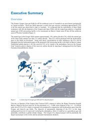
Geology <strong>and</strong> petroleum prospectivity <strong>of</strong> State Acreage Release <strong>Area</strong> <strong>L12</strong>-<strong>14</strong>, Southern Perth Basin<br />
D D'<br />
LEEUWIN<br />
INLIER<br />
0<br />
Kilometres<br />
Dunsborough<br />
Fault<br />
2<br />
4<br />
6<br />
8<br />
VASSE SHELF<br />
34°00'<br />
Cretaceous<br />
Jurassic<br />
Triassic<br />
Eastern Mentelle<br />
Sub-basin<br />
Yallingup<br />
Shelf<br />
Chapman Hill 1<br />
(projected)<br />
Busselton Fault<br />
Vertical exaggeration = 2.5<br />
D<br />
Permian<br />
Basement<br />
SNA57 23.07.12<br />
Offshore/onshore<br />
Phanerozoic basin<br />
Onshore/<strong>of</strong>fshore<br />
basement<br />
Acreage Release <strong>Area</strong><br />
<strong>L12</strong>-<strong>14</strong><br />
BUNBURY TROUGH<br />
Whicher Range 1<br />
Sabina River 1 (projected) Warnbro Group <strong>and</strong><br />
(projected)<br />
Bunbury Basalt<br />
Sabina S<strong>and</strong>stone<br />
50 km<br />
3<br />
Main unconformity<br />
115°00' 116°00'<br />
Leeuwin<br />
Inlier<br />
Augusta<br />
Gas discovery<br />
Vasse<br />
Shelf<br />
Busselton<br />
Bunbury<br />
Sabina River 1<br />
Chapman Hill 1<br />
Dunsborough Fault<br />
Vasse<br />
Shelf<br />
Busselton<br />
Sabina<br />
Fault<br />
Fault<br />
Sub-basin boundary<br />
Bunbury<br />
Trough<br />
<strong>L12</strong>-<strong>14</strong><br />
Wonnerup 1<br />
Whicher<br />
Range<br />
Gasfield<br />
Darradup<br />
Fault<br />
<strong>Petroleum</strong> exploration well, dry<br />
Other petroleum exploration wells<br />
Town<br />
Cattamarra Coal Measures<br />
Lesueur S<strong>and</strong>stone<br />
Stockton Group<br />
Sue Group<br />
Fault<br />
(717 km )<br />
2<br />
Darling Fault<br />
D’<br />
YILGARN<br />
CRATON<br />
Wonnerup<br />
prospect<br />
Section line<br />
D D’<br />
Gasfield<br />
YarragadeeYILGARN<br />
Formation CRATON<br />
Figure 2. Schematic geological cross-section <strong>of</strong> the Bunbury Trough (from Crostella <strong>and</strong> Backhouse, 2000; Ferdin<strong>and</strong>o <strong>and</strong><br />
Dedman, 2003)<br />
Darling Fault