10. Sites 143 and 144 - Deep Sea Drilling Project
10. Sites 143 and 144 - Deep Sea Drilling Project
10. Sites 143 and 144 - Deep Sea Drilling Project

Create successful ePaper yourself
Turn your PDF publications into a flip-book with our unique Google optimized e-Paper software.
SHIPBOARD SCIENTIFIC PARTY<br />
I0"<br />
8°<br />
56° 54 C<br />
200"<br />
53 C 52° 51 c<br />
' CIRCE 10<br />
GLOMAR CHALLENGER 14<br />
KANE 9<br />
KONINKLIJKE SHELL<br />
51"<br />
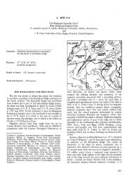
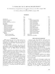
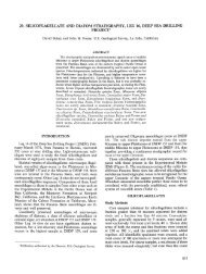
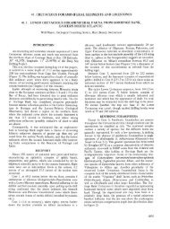
Figure 1. Location map for <strong>Sites</strong> <strong>143</strong>-<strong>144</strong>. Contours in nominal fathoms, modified from a map supplied by Koninklijke Shell<br />
(pers. comm.j. Letters key seismic profiles shown in Figures 2, 3 <strong>and</strong> 4.<br />
samples all indicate that progressively older strata outcrop<br />
along increasing depths of the northeast flank of the<br />
Demerara Rise. Resistant layers are suggested by small<br />
topographic terraces (Figure 4) along the flank. Care was<br />
taken to locate the sites slightly above such terraces to help<br />
ensure the presence of sufficient soft material to spud<br />
into.<br />
Privileged seismic data provided by Shell (Figure 2)<br />
indicate that a prominent angular unconformity exists at a<br />
depth of about 400 to 500 meters below the flat surface of<br />
the Demerara Plateau. The surface defining the unconformity<br />
is widespread <strong>and</strong> now lies at a depth of about 3000<br />
meters below sea level. The considerable relief on the north<br />
flank <strong>and</strong> our knowledge of the precise water depth at the<br />
drill site allows us to accurately locate Site <strong>144</strong> in relation<br />
to the Shell seismic profile <strong>and</strong> the surface of the<br />
284<br />
unconformity. A detailed interpretation of the Shell seismic<br />
profile is shown as part of the composite Figure 5.<br />
Seismic Reflection Data: Koninklijke/Shell Challenger<br />
Major reflector 0.32 sec None<br />
(top of unconformity)<br />
Reflector 0.80 sec<br />
The Demerara Rise was approached from the southeast<br />
to a point about 5 km from proposed Site <strong>143</strong>. The ship's<br />
course was then altered to 225 to duplicate one of the<br />
SHELL geophysical lines. It was intended to make a<br />
continuous traverse from the flat basin floor onto the<br />
northern slope of the Demerara Rise, however, the best<br />
available topographic base map for this area was in error<br />
<strong>and</strong> the Challenger turned at the base of the slope instead<br />
of within the flat basin floor.<br />
10°<br />
6°