10. Sites 143 and 144 - Deep Sea Drilling Project
10. Sites 143 and 144 - Deep Sea Drilling Project
10. Sites 143 and 144 - Deep Sea Drilling Project

Create successful ePaper yourself
Turn your PDF publications into a flip-book with our unique Google optimized e-Paper software.
Hole <strong>143</strong> A<br />
<strong>10.</strong> SITES <strong>143</strong> AND <strong>144</strong><br />
The Shipboard Scientific Party 1<br />
ABSTRACT<br />
Site <strong>143</strong> lies about halfway down the lower part of the<br />
Demerara Rise <strong>and</strong> Site <strong>144</strong> lies near the top just below the edge<br />
of the flat upper plateau, about 3 km southwest of Site <strong>143</strong> <strong>and</strong><br />
400 km north of the Guiana coast.<br />
Only one core of Cretaceous material was recovered at Site<br />
<strong>143</strong> (at sea floor) before technical problems necessitated ab<strong>and</strong>oning<br />
the site.<br />
A sequence of Oligocene at sea floor to Early Albian to Late<br />
Aptian sediments at a depth of 325 meters was recovered at Site<br />
<strong>144</strong>. Three small hiatuses were detected; one in the Late Eocene at<br />
46 meters; one at the Tertiary Cretaceous boundary at 147<br />
meters; <strong>and</strong> one between Late Campanian <strong>and</strong> Early Santonian at<br />
180 meters.<br />
The succession at Site <strong>144</strong> consists of Oligocene to Paleocene<br />
foraminifera-nannoplankton chalk ooze with Radiolaria in the<br />
Eocene. Paleocene <strong>and</strong> Maestrichtian sediments are mainly<br />
zeolitic marl. At 180 meters there is a pronounced lithology<br />
change to zeolitic calcareous carbonaceous shale, with a strong<br />
H2S odor, which is mainly of Senonian to Turonian age. Marl,<br />
quartzose marlstone, shelly limestone, <strong>and</strong> carbonaceous clay<br />
were deposited from Cenomanian to Aptian times.<br />
Sediments formed at the site of deposition, <strong>and</strong> those from<br />
neighboring marginal shelves <strong>and</strong> the continent, indicate regional<br />
subsidence over a long period of time. The area of Site <strong>144</strong> was a<br />
poorly oxygenated environment in the Cretaceous with abundant<br />
quartz, carbonate, <strong>and</strong> organic matter introduced from upslope<br />
into this area of clay deposition. In the Tertiary, fertility<br />
increased <strong>and</strong> pelagic constituents began to dominate in a<br />
well-oxygenated environment at the sea floor.<br />
SITE DATA<br />
Time: 2200 November 19, 1970<br />
0130 November 21, 1970<br />
Position: 09° 28.45'N<br />
54° 18.71'W<br />
Water Depth: 11,460 feet<br />
1,845 nominal fathoms<br />
3,493 meters<br />
Cores Taken: One core<br />
Hole <strong>144</strong><br />
Time: 1658 November 23, 1970<br />
1206 November 27, 1970<br />
Position: 09° 27.23'N<br />
54° 20.52'W<br />
D. E. Hayes, Lamont-Doherty Geological Observatory of Columbia<br />
University, Palisades, New York; A. C. Pimm, Scripps Institution<br />
of Oceanography, La Jolla, California; W. E. Benson, National<br />
Science Foundation, Washington, D. C; W. H. Berger, Geologisch<br />
Palaeontologisches Institut-Kiel, Kiel, Germany; U. von Rad,<br />
Bundesanstalt für Bodenforschung-Hannover, Hannover, Germany;<br />
P. R. Supko, Scripps Institution of Oceanography, La Jolla,<br />
California; J. P. Beckmann, Geologisches Institut-Zurich, Zurich,<br />
Switzerl<strong>and</strong>; P. H. Roth, Geologisches Institut-Zurich, Zurich,<br />
Switzerl<strong>and</strong>.<br />
Water Depth:<br />
Cores Taken:<br />
9,702 feet<br />
1,573 nominal fathoms<br />
2,957 meters<br />
Seventeen cores<br />
SITES <strong>143</strong> AND <strong>144</strong> - BACKGROUND, SURVEY<br />
AND OPERATIONS<br />
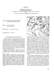
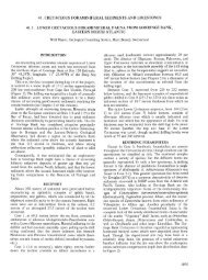
<strong>Sites</strong> <strong>143</strong> <strong>and</strong> <strong>144</strong> are located respectively on the steep<br />
lower part <strong>and</strong> near the flat upper plateau of the Demerara<br />
Rise (Figure 1). The Demerara Rise is a prominent<br />
topographic terrace that extends northward as part of the<br />
continental slope <strong>and</strong> margin of the Guiana coastal area.<br />
One sample of Cretaceous <strong>and</strong> one of Jurassic marine<br />
sediments have been collected on the flank of the rise. One,<br />
a dredge sample from the Kane has been reported by Fox et<br />
al. (1970). A piston core (located close to Site <strong>143</strong>) ta^en<br />
by geologists at Koninklijke/Shell <strong>and</strong> reported to the<br />
DSDP as privileged information, penetrated silty shales only<br />
2 meters below the sea floor <strong>and</strong> was dated as Barremian to<br />
Aptian on the basis of sporomorphs.<br />
In popular pre-drift continental reconstructions, the<br />
Guiana <strong>and</strong> Venezuela coasts of South America define one<br />
boundary of a pro to-Atlantic ocean <strong>and</strong> according to these<br />
hypotheses should have extremely old marine sediments<br />
deposited there. A primary objective of <strong>Sites</strong> <strong>143</strong>-<strong>144</strong> was<br />
to drill <strong>and</strong> sample very old sediments. Seismic reflection<br />
records (Figures 2, 3,4), bathymetric data, <strong>and</strong> the bottom<br />
283
SHIPBOARD SCIENTIFIC PARTY<br />
I0"<br />
8°<br />
56° 54 C<br />
200"<br />
53 C 52° 51 c<br />
' CIRCE 10<br />
GLOMAR CHALLENGER 14<br />
KANE 9<br />
KONINKLIJKE SHELL<br />
51"<br />
Figure 1. Location map for <strong>Sites</strong> <strong>143</strong>-<strong>144</strong>. Contours in nominal fathoms, modified from a map supplied by Koninklijke Shell<br />
(pers. comm.j. Letters key seismic profiles shown in Figures 2, 3 <strong>and</strong> 4.<br />
samples all indicate that progressively older strata outcrop<br />
along increasing depths of the northeast flank of the<br />
Demerara Rise. Resistant layers are suggested by small<br />
topographic terraces (Figure 4) along the flank. Care was<br />
taken to locate the sites slightly above such terraces to help<br />
ensure the presence of sufficient soft material to spud<br />
into.<br />
Privileged seismic data provided by Shell (Figure 2)<br />
indicate that a prominent angular unconformity exists at a<br />
depth of about 400 to 500 meters below the flat surface of<br />
the Demerara Plateau. The surface defining the unconformity<br />
is widespread <strong>and</strong> now lies at a depth of about 3000<br />
meters below sea level. The considerable relief on the north<br />
flank <strong>and</strong> our knowledge of the precise water depth at the<br />
drill site allows us to accurately locate Site <strong>144</strong> in relation<br />
to the Shell seismic profile <strong>and</strong> the surface of the<br />
284<br />
unconformity. A detailed interpretation of the Shell seismic<br />
profile is shown as part of the composite Figure 5.<br />
Seismic Reflection Data: Koninklijke/Shell Challenger<br />
Major reflector 0.32 sec None<br />
(top of unconformity)<br />
Reflector 0.80 sec<br />
The Demerara Rise was approached from the southeast<br />
to a point about 5 km from proposed Site <strong>143</strong>. The ship's<br />
course was then altered to 225 to duplicate one of the<br />
SHELL geophysical lines. It was intended to make a<br />
continuous traverse from the flat basin floor onto the<br />
northern slope of the Demerara Rise, however, the best<br />
available topographic base map for this area was in error<br />
<strong>and</strong> the Challenger turned at the base of the slope instead<br />
of within the flat basin floor.<br />
10°<br />
6°
..<br />
-<br />
•••• .<br />
jùi<br />
: "*••j<br />
to<br />
00<br />
ON<br />
G<br />
4-<br />
8-t<br />
Figure 3. Seismic records from Koninklijke Shell (pers. comm.) see Figure 1 for profile location. Profile E-F passes almost directly over <strong>Sites</strong> <strong>143</strong> <strong>and</strong> <strong>144</strong>. The estimated<br />
positions of these sites relative to the Shell profiles are indicated. Note the pronounced irregular unconformity shown on Profile GH at about 0.5-0.6 sec<br />
depth.<br />
F<br />
00<br />
n<br />
m<br />
z<br />
H<br />
O<br />
><br />
H
to<br />
00<br />
4-4<br />
CAMERA 66<br />
DREDGE 30<br />
Figure 4. Seismic profiles from Kane 9. (Lowrie <strong>and</strong> Escowitz, 1969). See Figure 1 for profile location. The arrow indicates the comparable position of Site <strong>144</strong> relative<br />
to the Kane profile. Note the apparent outcropping of deep strata defined by prominent reflectors <strong>and</strong> expressed as topographic benches.
SHIPBOARD SCIENTIFIC PARTY<br />
288<br />
SQNO3BS<br />
NI Hid3Q<br />
5.<br />
05<br />
I<br />
I<br />
.§><br />
As the Challenger was unable to obtain a good quality<br />
seismic profile up the steep slope of the rise, the final<br />
selection of Site <strong>143</strong> had to be made on the basis of water<br />
depth <strong>and</strong> the bottom character as seen on the precision<br />
depth recorder. Two holes (<strong>143</strong> <strong>and</strong> <strong>143</strong>A) were attempted<br />
at the site selected <strong>and</strong> three more (<strong>143</strong>B, C, D) at a<br />
location 300 meters downslope. These latter were made in<br />
an attempt to avoid moderately hard formations at or close<br />
to the surface, but the deepest penetration obtained was<br />
only 40 meters (Hole <strong>143</strong>C). Only one core in Hole <strong>143</strong>A<br />
was recovered from all five holes attempted at this site.<br />
As Site <strong>144</strong> was only 4 km southwest of Site <strong>143</strong>, the<br />
geophysical gear was not towed <strong>and</strong> again site selection was<br />
made using the depth recorder. Operations proceeded<br />
smoothly at this site <strong>and</strong> a summary of drilling <strong>and</strong> coring is<br />
given in Figure 6 <strong>and</strong> Table 1.<br />
SITE <strong>143</strong><br />
General<br />
Only one core was recovered at this Site. It is highly<br />
contaminated with Recent material, but also contains some<br />
Cretaceous foraminifera <strong>and</strong> nannoplankton. These indicate<br />
an age of Late Albian to Cenomanian. The fossil assemblage<br />
is very similar to that of Core 5 in Site <strong>144</strong>. The sediment<br />
recovered was conglomeratic s<strong>and</strong> <strong>and</strong> gravel. The lithic<br />
fragments were as follows: green mudstone, subangular<br />
medium-grained quartz s<strong>and</strong>stone, Fe oxide crusts associated<br />
with greenish gray shale, Fe/Mn fragments, <strong>and</strong> silty<br />
quartzose fine-grained s<strong>and</strong>stone. The disaggregated nature<br />
of the core material <strong>and</strong> its very heterogeneous nature<br />
strongly suggest a talus deposit. The age diagnostic fossils<br />
for this core is given in Table 2.<br />
SITE <strong>144</strong> BIOSTRATIGRAPHY<br />
General<br />
Abundant planktonic foraminifera, nannoplankton <strong>and</strong><br />
Radiolaria occur in the chalks <strong>and</strong> marls in the upper part<br />
of the holes drilled at this site. Rich Oligocene microfaunas<br />
<strong>and</strong> nannofloras were recovered from <strong>144</strong>B-1, B-2, A-2, B-3<br />
<strong>and</strong> A-2 (upper part). Some admixed Quaternary, Pliocene,<br />
<strong>and</strong> Miocene planktonic foraminifera in <strong>144</strong>B-1, <strong>and</strong> a trace<br />
of Upper Miocene with nannoplankton at the top of<br />
<strong>144</strong>A-2, indicate that younger sediments are now, or were<br />
at one time, overlying the Oligocene in this area. An<br />
unconformable contact of Lower Oligocene or Middle<br />
Eocene was recovered in <strong>144</strong>A-2. Below the Middle Eocene<br />
of <strong>144</strong>-1, Upper Paleocene sediments with planktonic<br />
foraminifera nannoplankton <strong>and</strong> radiolarians were<br />
encountered in <strong>144</strong>-2 <strong>and</strong> <strong>144</strong>A-3 where they overlie Lower<br />
Maestrichtian. Rich Maestrichtian radiolarian assemblages<br />
occur in <strong>144</strong>-3. Another unconformity was found between<br />
<strong>144</strong>A-4 <strong>and</strong> A-5 where Upper Campanian rests onConiacian<br />
to Santonian. Monotonous assemblages of small planktonic<br />
foraminifera <strong>and</strong> fairly rich nannoplankton occur in<br />
<strong>144</strong>A-5, A-6 <strong>and</strong> 4. Mainly benthonic foraminifera,<br />
common ostracods, pelecypods, <strong>and</strong> gastropods (all<br />
indicating shallow water), <strong>and</strong> rather poor assemblages of<br />
nannoplankton were found in <strong>144</strong>-6, 7 <strong>and</strong> 8.
Description<br />
Drill<br />
Core 1<br />
Drül<br />
Core 2<br />
Drill<br />
Core 3<br />
Drill<br />
Core 4<br />
Drill<br />
Core 5<br />
Core 6<br />
Core 7<br />
Drül<br />
Core 8<br />
Drül<br />
Core 1<br />
Drül<br />
Core 2<br />
Drül<br />
Core 3<br />
Drül<br />
Core 4<br />
Core 5<br />
Core 6<br />
Core 1<br />
Core 2<br />
Core 3<br />
TABLE 1<br />
<strong>Drilling</strong> <strong>and</strong> Coring Record for Site <strong>144</strong><br />
Interval Below<br />
<strong>Sea</strong> Floor<br />
(m)<br />
0.57<br />
57-65<br />
65-85<br />
85-104<br />
104-112<br />
112-123<br />
123-<strong>143</strong><br />
<strong>143</strong>-162<br />
162-166<br />
166-213<br />
213-219<br />
219-227<br />
227-237<br />
237-264<br />
264-270<br />
270-274<br />
274-292<br />
292-295<br />
295-298<br />
298-300<br />
300-324<br />
324-327<br />
0-20<br />
20-29<br />
29-38<br />
38-47<br />
47-94<br />
94-113<br />
113-133<br />
133-140<br />
140-149<br />
149-152<br />
152-171<br />
171-180<br />
180-189<br />
189-197<br />
0-9<br />
10-19<br />
27-36<br />
HOLE <strong>144</strong><br />
HOLE <strong>144</strong>A<br />
HOLE <strong>144</strong>B<br />
Core Recovery<br />
(m)<br />
8.0<br />
8.0<br />
2.2<br />
3.3<br />
1.5<br />
1.0<br />
0.7<br />
3.0<br />
7.3<br />
9.2<br />
9.0<br />
1.9<br />
0.6<br />
0.7<br />
9.2<br />
9.1<br />
8.6<br />
<strong>Drilling</strong> Rate<br />
(m/min)<br />
0.7 a<br />
0.4<br />
0.4<br />
0.8<br />
1.0<br />
1.1<br />
0.5<br />
0.4<br />
0.1<br />
0.5<br />
0.2<br />
0.2<br />
SHIPBOARD SCIENTIFIC PARTY<br />
290<br />
TABLE 2<br />
DIAGNOSTIC FOSSILS HOLE <strong>143</strong>A<br />
FORAMINIFERA NANNOPLANKTON AGE<br />
Samples of the core contain mainly Recent<br />
planktonic foraminifera <strong>and</strong> fish debris.<br />
However, in the material recovered from<br />
outside the twisted <strong>and</strong> damaged core liner<br />
were found small-sized specimens of<br />
Globigerinelloides aaseyi, Hedbergella<br />
amábitiβ, ü. pianispira, Neobulimina minima,<br />
<strong>and</strong> Epistomina lacunosa.<br />
Age: Albian-Cenomanian (probably age<br />
equivalent to the Washita Stage of the U.S.<br />
Gulf Coast).<br />
Poor assemblage including Cretarhábdus aorona -<br />
ventisy Pavhabdolithus angustus} Podorhabdus<br />
orbiaulofenestrus, Corollithion achyosum,<br />
Corollithion signum, Braarudosphaera bigelowi,<br />
Cylindralithus sp.<br />
Age: Late Albian - Cenomanian.<br />
Late<br />
Albian-<br />
Cenomanian
TABLE 3<br />
DIAGNOSTIC FOSSILS HOLE <strong>144</strong><br />
SITES <strong>143</strong> AND <strong>144</strong><br />
FORAMINIFERA NANNOPLANKTON AGE<br />
Rich, predominantly planktonic fauna with<br />
Globorotalia crassata, Gr. renzi, Gr.<br />
pomeroli, Globigerina senni, Catapsydrax<br />
dissimilis (Sec. 1 to 3), Orbulinoides beckmanni,<br />
Globigerinatheka barri, Chiloguembelina<br />
martini, Nuttallides truempyi.<br />
Age: Middle Eocene, Orbulinoides beokmanni<br />
Zone.<br />
Rich, predominantly planktonic faunas with<br />
Globorotalia velascoensis, Gr. pseudomenardii,<br />
Gr. pusilla laevigata, Gr. aequa,<br />
Aragonia velascoensis, <strong>and</strong> Neoflabellina<br />
jarvisi.<br />
Contamination with Eocene <strong>and</strong> Pliocene<br />
to recent material.<br />
Age: Late Paleocene, Globorotalia pseudomenardii<br />
Zone.<br />
Fairly rich faunas with Globotrunaana caliciformis,<br />
Gt. fornicata, Gt. plurmerae, Gt. havanensis,<br />
Gt. stephensoni, Gt. area, Gt.<br />
ventricosa, Heterohelix punatulata, H.<br />
ultimatumida, Pseudoguembelina oostulata,<br />
Globigerinelloides yauooensis, G. volutus,<br />
Hugoglobigerina rugosa, R. cf/Ihexacamerata,<br />
Rugotrunoana subpennyi, Bolivina inarassata,<br />
Pyramidina szajnochae, Cibicides stephensoni,<br />
Gaudryina laevigata, Bulimina arkadelphiana,<br />
Neoflabellina sp. aff. numismalis, Aragonia<br />
velascoensis, <strong>and</strong> Rzehakina epigona lata.<br />
Age: Late Cretaceous, Late Campanian<br />
(or early Maestrichtian?), upper part<br />
of Globotruncana fornicata - G. stuartiformis<br />
Zone.<br />
Fairly rich planktonic faunas with<br />
Hedbergella delrioensis, H. brittonensis,<br />
Heterohelix reussi, H. moremani, H. cf.<br />
frizzelli, Globigerinelloides bentonensis,<br />
<strong>and</strong> G. caseyi.<br />
Age: Late Cenomanian to Early Turonian<br />
(Eagle Ford Stage of U.S. Gulf Coast<br />
stratigraphy).<br />
Fairly rich, mainly planktonic faunas with<br />
Hedbergella washitensis, H. planispira,<br />
H. gautierensis, Globigerinelloides caseyi,<br />
G. bentonensis, Textularia washitensis,<br />
Epistomina lacunosa, Discorbis minutissima,<br />
Neobulimina minima.<br />
Age: Late Albian or Early Cenomanian<br />
(Washita Stage of U.S. Gulf Coast terminology).<br />
Rich assemblages with Ch.iasmolith.us gr<strong>and</strong>is,<br />
Ch. solitus, Campylosphaera dela, Reticulofenestra<br />
umbiliaa, Discoaster barbadiensis,<br />
D. saipanensis, D. tani nodifer, Sphenolithus<br />
predistentus, S. pseudoradians.<br />
Preservation: E] -01.<br />
Zone: Reticulofenestra umbilica.<br />
Age: Middle Eocene<br />
Abundant nannoplankton including Discoaster<br />
multiradiatus, D. mediosus, Campylosphaera<br />
eodela, Chiasmolithus bidens <strong>and</strong> Cruciplacolithus<br />
eminens.<br />
Preservation: Ej - 01.<br />
Zone: Discoaster multiradiatus.<br />
Age: Late Paleocene<br />
Rich <strong>and</strong> diversified assemblages including<br />
Prediscosphaera cretacea, Cribrosphaerella<br />
ehrenbergi, Microrhabdulus decoratus, Arkhangelskiella<br />
cymbiformis, Micula staurophora,<br />
Tetralithus aculeus, Tetralithus obscurus,<br />
Tetralithus pyramidus, Kamptnerius magnificus,<br />
Kamptnerius punctatus, Tetralithus gothicus,<br />
Tetralithus gothicus trifidus, Cylindra<br />
lithus serratus.<br />
Age: Late Campanian - Early Maestrichtian.<br />
Common nannoplankton with Cretarhábdus<br />
coronadventis, Prediscosphaera cretacea,<br />
Eiffellithus turriseifeli, Chiastozygus<br />
cuneatus, Zygodiscus exiguuSj Podorhabdus<br />
orbiculofenestrus, Broinsonia lata +<br />
Broinsonia bevieri, Corollithion signum,<br />
Staux>olithites matalosus.<br />
Age: Cenomanian.<br />
Rather poor assemblages including Cretarhábdus<br />
coronadventis, Hayesites albiensis, Parhabdolithus<br />
angustus, Lithastrinus floralis,<br />
Corollithion achylosum, Staurolithites matalosus,<br />
Braarusosphaera africana.<br />
Age: Late Aptian - Early Albian.<br />
Middle<br />
Eocene<br />
Late<br />
Paleocene<br />
Late<br />
Campanian-<br />
Early<br />
Maestrichtian<br />
Late<br />
Cenamanian•<br />
Early<br />
Turonian<br />
Late<br />
Aptian-<br />
Early<br />
Cenomanian<br />
291
SHIPBOARD SCIENTIFIC PARTY<br />
292<br />
TABLE 3 - Continued<br />
DIAGNOSTIC FOSSILS HOLE <strong>144</strong><br />
FORAMINIFERA NANNOPLANKTON AGE<br />
Rather poor, mainly benthonic faunas with<br />
Lituola subgoodl<strong>and</strong>ensis, Lentiaulina saxoaretaaea,<br />
Textularia washitensis, Epistomina<br />
laaunosa, <strong>and</strong> Hedbergella washitensis.<br />
Common Ostracoda <strong>and</strong> remains of Echinoderms.<br />
Age: Late Albian or ?Early Cenomanian<br />
(Washita Stage).<br />
Apart from local concentrations of small<br />
mollusks, this core contains a poor benthonic<br />
assemblage with Lituola subgoodl<strong>and</strong>ensis,<br />
Lentiaulina saxoaretaaea, <strong>and</strong> an Orbitolinid?<br />
(Gen. indet.) Ostracods are fairly common<br />
<strong>and</strong> include Cytherella gr. parallela/ovata, Anis<br />
oσythere rotundata, <strong>and</strong> Cythereis spp. (det.<br />
H. J. üertli).<br />
Age: Late Aptian to Albian (Trinity to lower<br />
Washita Stage of U.S. Gulf Coast).<br />
Fairly rich, predominantly benthonic faunas<br />
with Lituola subgoodl<strong>and</strong>ensis, Textularia<br />
rioensis, Spiropleatammina alex<strong>and</strong>eri, Lingulina<br />
nodosaria, Quinqueloculina sabella, Disaorbis<br />
minutissima, Patellina subaretaoea,<br />
Guembelitria harrisi, <strong>and</strong> Hedbergella sp.<br />
(cf. washitensis). Also present are coproliths<br />
(Coptoaampylodon lineolaturn), small<br />
mollusks, remains of echinoderms, <strong>and</strong><br />
ostracods.<br />
Age: Albian (to Late Aptian?), probably<br />
corresponding to the Fredericksburg or lower<br />
Washita Stages of the U.S. Gulf Coast.<br />
Poor nannoflora with Parhabdolithus angustus,<br />
Lithastrinus floralis, Corollithion aahylosum,<br />
Siaurolithites matalosus,.<br />
Age: Late Aptian - Early Albian.<br />
Rare nannoplankton with Parhabdolithus angustus,<br />
Lithastrinus floralis, Corollithion aahylosum,<br />
Staurolithites matalosus, Braarusosphaera<br />
afriaana.<br />
Age: Late Aptian - Early Albian.<br />
Rare nannoplankton with Parhabdolithus angustus,<br />
Lithastrinus floralis, Corollithion aahylosum,<br />
Staurolithites matalosus, Braaruβosphaera<br />
afriaana.<br />
Age: Late Aptian - Early Albian.<br />
Late<br />
Aptian-<br />
Early<br />
Cenomanian<br />
Late<br />
Aptian-<br />
Albian.<br />
Late<br />
Aptian-<br />
Albian.
TABLE 3A<br />
DIAGNOSTIC FOSSILS HOLE <strong>144</strong>./V<br />
SITES <strong>143</strong> AND <strong>144</strong><br />
FORAMINIFERA NANNOPLANKTON AGE<br />
Rich, predominantly planktonic faunas with<br />
Globigerina ampliapertura, Globigerina venezuelana3<br />
Chiloguembelina aubensis, Cassigerinella<br />
ahipolensis, <strong>and</strong> Pseudohastigerina barbadoensis.<br />
In the upper part of Sec. 1 mixed with a mainly<br />
Pliocene fauna with Globorotalia exilis, Sphaeroidinella<br />
dehisoens "immatura" etc.<br />
Age: Early Oligocene, Cassigerinella ahipolensis/"Hastigerina<br />
micra" Zone.<br />
Sec. 1 to Sec. 6, cm 112: Rich, mainly<br />
planktonic faunas with Globigerina ampliapertura<br />
Gg. venezuelana, Globorotalia opima nana, Gr.<br />
gemma, Catapsydrax dissimilis, Chiloguembelina<br />
cubensis, Cassigerinella ahipolensis,<br />
Pseudohastigerina barbadoensis.<br />
Age: Earl,y Oligocene, Cassigerinella Chipolensis/"Hastigerina<br />
miara" Zone.<br />
Sec. 6, cm 120 to Core Catcher: Rich,<br />
predominantly planktonic faunas with<br />
Globorotalia crassata, Gr. renzi, Gr. pomeroli,<br />
Globigerina senni, Globigerinatheka barri,<br />
Hantkenina longispina, Trunaorotaloides rohri,<br />
Pseudohastigerina miara, Chiloguembelina cubensis,<br />
<strong>and</strong> Ch. martini.<br />
Age: Late Middle Eocene, Trunaorotaloides rohri<br />
Zone.<br />
Sec. 1 to Sec. 5, cm 98: Rich, predominantly<br />
planktonic faunas with Globorotalia<br />
velascoensis, Gr. pseudomenardii (rare),<br />
Gr. pusilla pusilla (Sec. 4 <strong>and</strong> 5), Gr.<br />
pusilla laevigata, Gr. ehrenbergi, Gr. aequa,<br />
Aragonia velasaoensis, Bolivinoides<br />
deliaatulus, Neoflabellina subretioulata.<br />
In Sec. 5 also a few apparently reworked<br />
specimens of Globorotalia trinidadensis<br />
<strong>and</strong> Gr. unainata.<br />
Age: Late Paleocene, Globorotalia pseudomenardii<br />
Zone (lower part).<br />
Sec. 5, cm 98, to Core Catcher: Rich,<br />
predominantly planktonic faunas with<br />
Globotrunaana stuartiformis, Gt. fornioata,<br />
Gt. stephensoni, Gt. havanensis, Gt. aegyptiaca,<br />
Gt. area, Gt. trioarinata, üeterohelix punatulata<br />
H. ultimatumida, Pseudoguembelina aostulata,<br />
Rugoglobigerina hexaaamerata, Rugotrunaana<br />
subpennyi, Bolivina inerassata, Pyramidina<br />
szajnochae, Marssonella oxyoona trinitatensis,<br />
<strong>and</strong> Aragonia velasaoensis.<br />
Age: Late Cretaceous, probably Early<br />
Maestrichtian (upper part of Globotruncana<br />
fornicata-stuartiformis Zone).<br />
Top of Section 1: Disaoaster brouweri,<br />
D. quinqueramus, D. variabilis, Ceratolithus<br />
trioorniculatus.<br />
Zone: Disaoaster quinqueramus.<br />
Age: Late Miocene<br />
Lower part of Section 1 through 2: Sphenolithus<br />
predistentus, S. distentus, Retiaulofenestra<br />
hillae, Helioopohtosphaera euphratis.<br />
Zone: Sphenolithus predistentus.<br />
Age: Early Oligocene.Sections 3 through 6:<br />
Sphenolithus predistentus, Retiaulofenestra<br />
umbilioa, R. hillae, Helioopontosphaera<br />
retiaulata, H. euphratis.<br />
Preservation: El - 01.<br />
Zone: Heliaopontosphaera retiaulata.<br />
Age: Early Oligocene.<br />
Sections 1 through 6: Ericsonia subdistioha,<br />
Retiaulofenestra umbiliaa, Cycloaoocolithina,<br />
formosa, Heliaopontosphaera retiaulata, H.<br />
aompacta, Sphenolithus predistentus, S.<br />
tribulosus.<br />
Preservation: Ei - 01.<br />
Zone: Eriasonia sübdistiaha.<br />
Age: Early Oligocene.<br />
Core Catcher: Chiasmolithus gr<strong>and</strong>is, Disaoaster<br />
barbadiensis, D. saipanensis.<br />
Zone: Retiaulofenestra umbiliaa.<br />
Age: Middle Eocene.<br />
This core contains an unconformable contact<br />
of Upper Paleocene on Lower Maestrichtian.<br />
Sections 1 through 3: Disaoaster mohleri,<br />
Ellipsolithus maoellus, Zygodiscus sigmoides,<br />
Chiasmolithus consuetus.<br />
Zone: Disaoaster mohleri.<br />
Sections 4 <strong>and</strong> 5 (top): Heliolithus kleinpellii,<br />
Zygolithus aonainnus, Ellipsolithus maaellus,<br />
Fasaiaulithes tympaniformis.<br />
Zone: Eeliolithus kleinpellii.<br />
Section 5 (40cm - 95cm): Fasaiaulithes tympaniformis,<br />
Chiasmolithus californicus, Cruaiplacolithus<br />
eminens.<br />
Zone: Fasoioulithes tympaniformis.<br />
Age: Late Paleocene.<br />
Preservation: El - 01 (whole core).<br />
Section 5 (105-107cm)<br />
(135-137cm).<br />
<strong>and</strong> Section 6: Kamptnerius punotatus, Tetralithus<br />
aauleus, Tetralithus gothiaus gothiaus,<br />
Kamptnerius magnificus, Tetralithus gothiaus<br />
trifidus.<br />
Age: Late Campanian - Early Maestrichtian.<br />
Early<br />
Oligocene<br />
Early<br />
Oligocene<br />
(lower<br />
part<br />
Middle<br />
Eocene)<br />
Late<br />
Paleocene<br />
Early<br />
Maestrichti<br />
an<br />
293
SHIPBOARD SCIENTIFIC PARTY<br />
294<br />
TABLE 3A - Continued<br />
DIAGNOSTIC FOSSILS HOLE <strong>144</strong>A<br />
FORAMINIFERA NANNOPLANKTON AGE<br />
Fairly rich faunas with Globotrunoana havanensis<br />
Gt. plummerae, Gt. stephensoni, Gt. linneiaw.<br />
Heterohelix ultimatumida, H. globulosa, H.<br />
punotulata, Pseudoguembelina oostulata,<br />
Globigerinelloides yauooensis, Planoglobulina<br />
glábrata, Bolivina inorassata, Cibioides<br />
stephensoni, Bulimina taylorensis, Pyramidina<br />
szajnoohae, Gyroidina florealis, Neoflabellina<br />
sp. aff. nwnismalis, Pleurostomella torta,<br />
<strong>and</strong> Aragonia velasaoensis. The faunas are<br />
predominantly bethonic in the lower part of<br />
the core.<br />
Age: Late Campanian or Early Maestrichtian,<br />
Globotrunoana for>nioata - stuartiformis<br />
Zone.<br />
Rich, predominantly planktonic faunas with<br />
Globotrunoana difformis} Gt. indioa, Hedbergella<br />
Corollithion signum,<br />
Miororhabdulus deocratus, Mioula staurophora,<br />
Tetralithus pyramidus, Ahmuellerella ootoradiata,<br />
Lithastrinus grilli, Eiffellithus augustus,<br />
Microrhabdulus belgious.<br />
Age: Late Turonian - Early Santonian
CORE<br />
1<br />
2<br />
3<br />
FORAMINIFERA<br />
Rich, predominantly planktonic faunas with<br />
Globigerina ampliapertura, Gg. venezuelana,<br />
Globorotalia gemma, Catapsydrax dissimilis,<br />
Chiloguembelina cubensis, Cassigerinella βhipolensis.<br />
In Sections 1 to 3, these faunas are<br />
mixed with Quaternary, Pliocene, <strong>and</strong> Miocene<br />
species such as Globorotalia truncatulinoides,<br />
Gr. miocenica, Gr. tumida, Gv. cultrata, Gr.<br />
exilis, Gr. fohsi peripheroacuta, Globigerinoides<br />
ruber, G. obliquus, Sphaeroidinella<br />
dehiscens, <strong>and</strong> Sphaeroidinellopsis seminulina.<br />
Age: Early Oligocene, Globigerina ampliapertura<br />
Zone.<br />
Rich, predominantly planktonic faunas with<br />
Globigerina ampliapertura, Gg. venezuelana,<br />
ug. praebulloides, Gg. pera, Catapsydrax<br />
dissimilis, Chiloguembelina aubensis,<br />
Cassigerinella chipolensis, <strong>and</strong> Pseudohastigerina<br />
barbadoensis.<br />
Age: Early Oligocene, Cassigerinella chipolensis/<br />
"Hastigerina micra" Zone.<br />
Rich, predominantly planktonic faunas with<br />
Globigerina ampliapertura, Gg. venezuelana,<br />
Chiloguembelina oubensis, Cassigerinella<br />
ohipolensis, Pseudihastigerina barbadoensis.<br />
Age: Early Oligocene, Cassigerinella chipolensis/<br />
"Hastigerina micra" Zone.<br />
Organic Microfossils<br />
By D.O.J. Diederix, R. de Haan <strong>and</strong> W.O. Tichler 2<br />
Hole <strong>144</strong><br />
Core 3 Section 2: 137-139 cm:<br />
Barren of sporomorphs, <strong>and</strong> only a few indeterminate<br />
microplankton specimens.<br />
Core 4 Section 2: 27-29 cm:<br />
No sporomorphs or microplankton recovered.<br />
Core 4 Section 3: 140-142 cm:<br />
Barren of sporomorphs, <strong>and</strong> microplankton.<br />
TABLE 3B<br />
Core 5 Section 1: 40-42 cm:<br />
Rather rich sporomorph flora, containing abundant Classopollis<br />
classoides, common Araucariacites australis, Ephedripites<br />
sp., (Elaterosporites) Galeacornea klaszi rare (El.) G.<br />
verrucata, <strong>and</strong> Ephedripites spiralis.<br />
Age: Early Cretaceous, Albian to Cenomanian.<br />
Microplankton species found are Coronifera oceanicaj<br />
albertii, Odontochitina operculata <strong>and</strong> Dinopterygium<br />
cladoides.<br />
Age: Cretaceous, probably post-Aptian.<br />
Koninklijke/Shell Exploratie en Produktie Laboratorium<br />
DIAGNOSTIC FOSSILS HOLE <strong>144</strong>B<br />
NANNOPLANKTON<br />
Rich nannoflora with Sphenolithus predistentus,<br />
S. distentus, Reticulofenostra hillae,<br />
Helicopontosphaera euphratis.<br />
Preservation: 01.<br />
Zone: Sphenolithus predistentus.<br />
Age: Early Oligocene<br />
The same assemblages as in Core B2.<br />
Zone: Sphenolithus predistentus.<br />
Age: Early Oligocene.<br />
Diversi-fied assemblages including Ericsonia<br />
subdisticha, Reticulofenestra umbilica,<br />
Cyclococcolithina formosa, Sphenolithus<br />
predistentus, S. tribulosus, Helicopontosphaera<br />
reticulata.<br />
Preservation: El - 01.<br />
Zone: Ericsonia subdisticha.<br />
Age: Early Oligocene<br />
SITES <strong>143</strong> AND <strong>144</strong><br />
AGE<br />
Early<br />
Oligocene<br />
Early<br />
Oligocene<br />
Early<br />
Oligocene<br />
Core 6 Section 1 (bottom):<br />
Sporomorph flora poor in species, with Classopollis<br />
classoides, Perotriletes sp., Ephedripites sp., Araucariacites<br />
australis, <strong>and</strong> Galeacornea klaszi.<br />
Age: Possibly Albian to Cenomanian.<br />
Very poor microplankton flora with Trichodinium<br />
castaneum.<br />
Age: Late Hauterivian to Campanian.<br />
Core 7 Section 1: 100-102<br />
Rich sporomorph flora containing Ephedra spiralis,<br />
Perotriletes sp., Tricolpites sp., Zonalapollenites dampieri,<br />
Classopollis classoides, Leptolepidites psarosus, Eucommiidites<br />
troedsonii, Ephedripites spp., Galeacornea klaszi,<br />
Araucariacites australis, Camarozonosporites cf. insignis,<br />
Cicatricosisporites sp. C. cf. brevilaesuratus, <strong>and</strong> cf. Raistrickia<br />
obtusispina.<br />
Age: Albian to Cenomanian.<br />
Microplankton poorly represented, with Trichodinium<br />
castaneum <strong>and</strong> Dinopterygium cladoides.<br />
Age: Cretaceous, probably post-Aptian.<br />
Core 8 Section 3: 60-62 cm:<br />
A rather rich sporomorph flora with abundant Classopollis<br />
classoides, common Araucariacites australis,<br />
Ephedripites sp., (Elaterosporites) Galeocornea klaszi, Trilites<br />
sp. (Jardiné & Magloire 1963 type S. CI. 124), rare<br />
295
SHIPBOARD SCIENTIFIC PARTY<br />
Eucommiidites troedsonii, Zonalapollenites dampieri <strong>and</strong><br />
(Elaterosporites) Galeacornea verrucata.<br />
Age: Early Cretaceous, Albian to Cenomanian.<br />
Microplankton species found are Trichodinium castaneum<br />
<strong>and</strong> a specimen belonging probably toDinopterygium<br />
cladoides.<br />
Age: Cretaceous, probably post-Aptian.<br />
Hole <strong>144</strong> A<br />
CoreóCC:<br />
No sporomorphs recovered <strong>and</strong> only 1 specimen of the<br />
microplankton genus Dinogymnium.<br />
Age: Probably Senonian.<br />
SITE <strong>144</strong> LITHOSTRATIGRAPHIC SUMMARY<br />
Three holes (<strong>144</strong>, <strong>144</strong>A, <strong>and</strong> <strong>144</strong>B) were drilled at Site<br />
<strong>144</strong> on the outermost edge of Demerara Rise in a water<br />
depth of 2957 meters. Depth of penetration was 327, 197<br />
<strong>and</strong> 36 meters, respectively, for each hole. The following<br />
five lithostratigraphic units can be distinguished:<br />
Unit<br />
4<br />
1<br />
2<br />
3<br />
5<br />
296<br />
Cores<br />
B-l,<br />
B-2,<br />
A-l,<br />
B-3,<br />
A-2,<br />
1, 2<br />
A-3,<br />
3,<br />
A-4<br />
A-5,<br />
A-6,<br />
4<br />
5<br />
6,7,8<br />
Lithology<br />
Chalk ooze, 70-<br />
80% carbonate<br />
forams ~ nannos,<br />
Radiolarian rich in<br />
Eocene, slightly<br />
siliceous above<br />
<strong>and</strong> below<br />
Zeolitic greenish<br />
gray marl, 40-65%<br />
carbonate partly<br />
cemented (calcareous<br />
& siliceous) pyritic.<br />
Forams ~ nannos,<br />
lower part mostly<br />
carbonate<br />
fragments<br />
Zeolite black <strong>and</strong><br />
olive marl, 25-35%<br />
carbonate much<br />
organic matter<br />
marly LS beds:<br />
40-80% carbonate<br />
forams ~ nannos<br />
~ carbonaceousfragments<br />
pyrite,<br />
laminae & varves<br />
(?) glauconite &<br />
phosphorite in<br />
limestone, forams<br />
(benthonic><br />
planktonic) filled<br />
with sparry calcite<br />
Olive gray marl,<br />
slightly quartzose,<br />
30-70% carbonate,<br />
zeolitic, pyritic, few<br />
forams, nannos<br />
Quartzose marlstone,<br />
with shelly limestone<br />
<strong>and</strong> carbonaceous<br />
clay<br />
Depth Below<br />
<strong>Sea</strong> Floor<br />
(m)<br />
0-120 (?)<br />
120(?)-180<br />
180-240(?)<br />
240(?)-280<br />
280(?)-327+<br />
Age<br />
Oligocene-<br />
Paleocene<br />
Paleocene-<br />
Campanian<br />
Senonian-<br />
Cenomanian<br />
Early<br />
Turonian to<br />
Late Aptian<br />
Late Albian<br />
to Early<br />
Aptian<br />
UNIT 1 - Chalk Ooze (Cores B-l, B-2, A-l, B-3, A-2, 1, 2)<br />
Unit 1 is about 120 meters thick <strong>and</strong> is of Oligocene to<br />
Paleocene age. It is a marl-chalk ooze with about 70 per<br />
cent carbonate material, foraminifera (mainly benthonic)<br />
<strong>and</strong> coccoliths each contributing about equal amounts.<br />
Triturated carbonate is a minor component (
DEPTH<br />
IN<br />
METERS<br />
1OO-I<br />
200-<br />
300-<br />
DRILLING SPEED-METERS/MIN.<br />
400 J<br />
Figure 6. Summary of drilling <strong>and</strong> coring at Site <strong>144</strong>.<br />
The sediment is well burrowed (maximum vertical<br />
extent 2 cm) except in some parts of A-4 (base of unit).<br />
The pyrite formation appears to be early diagenetic rather<br />
than synsedimentary. Faint b<strong>and</strong>ing in A3 (top of unit),<br />
between lighter <strong>and</strong> darker greenish gray, suggests redeposition<br />
processes. The lighter material contains more zeolite,<br />
the darker is richer in carbonate.<br />
A hiatus of about 8 my was detected, based on<br />
paleontological data, at a depth of 147 meters. In the early<br />
Maestrichtian sedimentation rates were 5m/my.<br />
UNIT 3 - Zeolitic Black <strong>and</strong> Olive Marl (Cores A5, A6, 4)<br />
Unit 3 is about 60 meters thick <strong>and</strong> is Senonian to<br />
Cenomanian in age. It is characterized by a sequence of<br />
dark shales <strong>and</strong> clay with interrelated lime <strong>and</strong> marlstone<br />
beds several cm thick. Recovery is poor <strong>and</strong> this fact may<br />
distort the proportions of the various sediment types. They<br />
are, in order of decreasing abundance:<br />
1) Olive black <strong>and</strong> olive finely laminated calcareous<br />
carbonaceous clay <strong>and</strong> shale, which contains occasional<br />
lighter colored calcareous laminae <strong>and</strong> layers. The sediment<br />
consists of roughly equal parts of carbonate (~30%),<br />
organic matter, <strong>and</strong> clay, with about 10 to 20 per cent<br />
zeolite minerals. The olive clay contains distinctly less<br />
organic matter <strong>and</strong> more clay (Core 4, base of unit), The<br />
carbonate consists of forams, coccoliths, <strong>and</strong> triturated<br />
fragments in about equal amounts. Pyrite is present<br />
throughout <strong>and</strong> terrigenous components occur in traces.<br />
2) Foram rich olive carbonaceous limestone has a sparry<br />
calcite cement which also fills the foram tests. The<br />
limestone (80%) is rich in clay <strong>and</strong> organic matter. Some<br />
zeolite <strong>and</strong> a few radiolarians are also present.<br />
3) Grayish green glauconitic <strong>and</strong> phosphoritic marlstone<br />
contains common forams (mainly benthonic), pyrite <strong>and</strong><br />
1<br />
SITES <strong>143</strong> AND <strong>144</strong><br />
LITHOSTRATIGRAPHY<br />
UNIT NO. CORE<br />
4 5 NO.<br />
-I IB<br />
2B<br />
1A3B<br />
3A<br />
3<br />
5A 4A<br />
6A<br />
limonite <strong>and</strong> has a sparry cement. A thin section shows 25<br />
per cent fresh green glauconite, lobate grains, partly<br />
calcitized, <strong>and</strong> 25 per cent phosphate minerals (collophane,<br />
apatite, dahlite, fish teeth). Terrigenous minerals occur in<br />
traces.<br />
Sedimentation rates ranged from 3 to 4 m/my. <strong>Drilling</strong><br />
rates in this unit were >0.5 meter/minute.<br />
UNIT 4 - Olive Green Marl (Core 5)<br />
Unit 4, Late Aptian to Early Cenomanian in age, is about<br />
40 meters thick. Only 1.5 meters of sediment was recovered<br />
in this unit. Like Unit 3, this marl shows laminations <strong>and</strong> is<br />
slightly pyritic. The bulk of the carbonate (~50%) is<br />
provided by triturated "flour" rather than by whole fossil<br />
tests. Unit 4 has distinctly more quartz than Unit 3, about<br />
5 to 10 per cent. Zeolite is present also. Sediments<br />
accumulated at about 10 m/my. <strong>Drilling</strong> rates were much<br />
less than 0.5 meter/minute.<br />
UNIT 5 — Quartzose Marlstone with Shelly Limestone <strong>and</strong><br />
Carbonaceous Clay (Cores 6, 7, 8)<br />
This unit is at least 50 meters thick <strong>and</strong> is Late Aptian to<br />
Early Cenomanian in age. The sediment types recorded in<br />
Unit 5 are (from top to bottom) shelly limestone, silty<br />
marlstone, slightly quartzose zeolitic (?) clay, slightly<br />
quartose carbonaceous clay, coquina marl, quartzose calcareous<br />
silty calcareous clay stone, <strong>and</strong> mudstone.<br />
Carbonate content averages 30 per cent, with a range of<br />
from 10 per cent (carbonaceous clay) to 60 per cent (in<br />
part shelly limestone). All types have in common: (1) a<br />
relative high quartz content (15-40%); (2) organic matter<br />
(few %); (3) pyrite (few %); <strong>and</strong> (4) a sizable proportion of<br />
the carbonate present being provided by mollusk shell<br />
fragments. Nine-tenths of the recovered unit is burrowed<br />
297
SHIPBOARD SCIENTIFIC PARTY<br />
<strong>and</strong> mottled. Radiolarians are rare <strong>and</strong> are largely pyritized<br />
or (?) calcitized.<br />
The most distinctive lithologies are those of the shelly<br />
limestone in Core 6 <strong>and</strong> the quartzose <strong>and</strong> pyritic carbonaceous<br />
clay in Core 7. Most of the other lithologies are<br />
intermediate between these two types.<br />
The shelly limestone is dark greenish gray to olive gray,<br />
mottled <strong>and</strong> burrowed, <strong>and</strong> contains large (1-5 cm long)<br />
fragments of gastropods <strong>and</strong> pelecypods. A thin section<br />
shows 55 per cent CaCO3 (5% shells, 50% micrite <strong>and</strong><br />
sparry cement), 25 per cent very angular quartz, 5 per cent<br />
feldspar, 5 per cent micas, 3 per cent pyrite, 7 per cent clay<br />
minerals, <strong>and</strong> a trace of chert (?).<br />
The carbonaceous clay is dark greenish gray, homogenous<br />
with faint layering in places, <strong>and</strong> consists of clay<br />
minerals <strong>and</strong> organic matter with 20 per cent quartz, 3 per<br />
cent mica, 15 per cent pyrite, <strong>and</strong> 10 per cent carbonate<br />
(shell fragments, also forams). At least one claystone bed<br />
appears intraclastic. Near the base (Core 8, bottom) a<br />
slightly more calcareous clay is olive black <strong>and</strong> irregularly<br />
laminated.<br />
Sedimentation rates were about 3m/my.<br />
Sedimentation Trends<br />
1. Oxygenation: Except for the uppermost 10 meters,<br />
the whole section drilled contains pyrite <strong>and</strong> has greenish<br />
color, indicating reducing conditions within the sediment.<br />
Pyrite <strong>and</strong> organic matter contents are highest in the<br />
lowermost unit <strong>and</strong> laminated black sediments occur in<br />
places below 200 meters. The bulk of the sequence shows<br />
intense mottling <strong>and</strong> burrowing. A general increase of<br />
oxygenation from bottom to top of the section appears<br />
indicated, especially in post-Cretaceous sediments.<br />
2. Carbonate Content: The entire section is calcareous<br />
with marl predominating in the Cretaceous <strong>and</strong> low-grade<br />
chalk in the Early Tertiary. At the bottom of the section,<br />
much of the carbonate is provided by mollusk shells <strong>and</strong> by<br />
recrystallized calcite, by triturated calcite "flour" in about<br />
equal proportions (Units 3, 2, 1) <strong>and</strong> finally by forams <strong>and</strong><br />
nannos with minor "flour" (Unit 1, upper part).<br />
3. Opal Content: Below 150 meters, within the Cretaceous,<br />
siliceous fossils are very rare, except for occasional<br />
pyritized <strong>and</strong> calcitized (?) radiolarian fragments. Silicacemented<br />
marlstones appear in Core A3 (Unit 2) <strong>and</strong> from<br />
there on up siliceous fossils, especially radiolarians. There<br />
are also sponge spicules <strong>and</strong> unidentified opal platelets, are<br />
quite common (5% <strong>and</strong> more) with a distinct maximum<br />
(30% siliceous) in Core 1 (Unit 1, Mid-Eocene).<br />
4. Zeolite Content: Zeolites are common (5%) in Units<br />
2, 3, <strong>and</strong> 4, but are much less prominent at the base (Unit<br />
5) <strong>and</strong> at the top (Unit 1) of the sequence. Maximum<br />
zeolite contents (10-15%) are found within Paleocene/Late<br />
Cretaceous sediments between about 140 to 230 meters.<br />
5. Terrigenous Influx: Greatest contents of quartz <strong>and</strong><br />
associated mica are found at the base of the section<br />
(30-50%) (Unit 5). Contents decrease rapidly upwards (5%,<br />
Unit 4; 1% lower part of Unit 3) <strong>and</strong> are virtually absent<br />
above 200 meters (post-Cenomanian).<br />
6. Non-Terrigenous Redeposition: Evidence of redeposition<br />
is present throughout the sequence. Within Unit 5,<br />
the interbedding of shell beds <strong>and</strong> clay layers suggests<br />
298<br />
introduction of shallow water carbonate debris into a<br />
carbonate-poor clay sequence. A somewhat similar situation<br />
appears in Unit 4. Here the carbonate consists of finely<br />
triturated clasts which are concentrated in light colored<br />
layers (70%) that alternate with darker layers (35% carbonate)<br />
on a scale of a few millimeters to 2 cm. Boundaries<br />
are distinct, sometimes sharp. Similarly, Unit 3 consists of a<br />
calcareous clay sequence with apparently redeposited lime<br />
<strong>and</strong> marl beds that are rich in benthonic forams <strong>and</strong> (in<br />
places) in glauconite <strong>and</strong> phosphorite. Alternations between<br />
carbonate <strong>and</strong> zeolite-rich b<strong>and</strong>s in Unit 2 again suggest<br />
redeposition processes, as do lithified layers rich in carbonate.<br />
The mixture of different kinds of ooze clasts within<br />
a soupy matrix in Unit 1 also may be due to redeposition<br />
processes, although the possible effects of drilling on these<br />
disturbances are not clear.<br />
SITE <strong>144</strong> PHYSICAL AND CHEMICAL PROPERTIES<br />
The physical <strong>and</strong> chemical properties of the sediments<br />
cored at Site <strong>144</strong> suggest a three-fold division of the<br />
section: 1) upper, unit (0-112 m) consisting of chalk oozes,<br />
Oligocene to Late Paleocene in age; 2) middle unit (140-220<br />
m) consisting of calcareous mudstones <strong>and</strong> carbonaceous<br />
clays Early Paleocene to Turonian in age; <strong>and</strong> 3) lower unit<br />
(264-327 m), quartzose calcareous mudstones, marls, <strong>and</strong><br />
limestones, more indurated than the middle unit, Albian<br />
<strong>and</strong> Aptian in age. The upper unit corresponds to Unit I of<br />
the lithologic summary; the middle unit, to Units II <strong>and</strong> III,<br />
<strong>and</strong> the lower unit to Units IV <strong>and</strong> V.<br />
Wet-Bulk Density <strong>and</strong> Porosity<br />
GRAPE measurements (Table 4) of the bulk density<br />
(gm/cc) <strong>and</strong> porosity (%) suggest the three-fold division<br />
noted above correlates well with detailed changes in<br />
Lithology. Bulk densities of relatively undisturbed parts of<br />
the chalk oozes of the upper unit fall mainly between 1.3<br />
<strong>and</strong> 1.6, with mean values increasing slightly with depth.<br />
Porosities average about 70 per cent. Lower bulk densities<br />
<strong>and</strong> higher porosities correlate with softer sediments which<br />
were probably disturbed by drilling.<br />
Bulk densities average about 1.75, <strong>and</strong> the porosities run<br />
65 to 70 per cent for the middle unit of calcareous<br />
mudstones <strong>and</strong> zeolitic carbonaceous clays. Deviations from<br />
the mean correspond to beds of less compacted clay <strong>and</strong><br />
beds of cemented marly limestone.<br />
In the lower unit (265 to 327 m) bulk density runs 1.7<br />
to 1.9; porosity ranges from 20 to 40 per cent.<br />
Water Content<br />
Water content decreases with depth from about 40 per<br />
cent at the top to about 16 per cent at 300 meters.<br />
Natural Gamma<br />
Variation in the natural gamma counts correlates well<br />
with the detailed Lithology. Except for high counts in the<br />
topmost two meters of the section (common in many<br />
oceanic deposits), gamma readings are low (50-600) in the<br />
oozes of the upper unit. In the middle unit, gamma counts<br />
range from 500 to 1300 in the calcareous mudstones <strong>and</strong><br />
from 1100 to 2600 in the carbonaceous clays. The<br />
variations appear to correlate with the zeolite content of
SITES <strong>143</strong> AND <strong>144</strong><br />
TABLE 4<br />
Summary of Density, Porosity <strong>and</strong> Water Content Data for <strong>Sites</strong> <strong>143</strong> <strong>and</strong> <strong>144</strong><br />
Hole<br />
<strong>143</strong><br />
<strong>143</strong><br />
<strong>144</strong><br />
<strong>144</strong><br />
<strong>144</strong><br />
<strong>144</strong><br />
<strong>144</strong><br />
<strong>144</strong><br />
<strong>144</strong><br />
<strong>144</strong><br />
<strong>144</strong><br />
<strong>144</strong><br />
<strong>144</strong><br />
<strong>144</strong><br />
<strong>144</strong><br />
<strong>144</strong><br />
<strong>144</strong><br />
<strong>144</strong><br />
<strong>144</strong><br />
<strong>144</strong><br />
<strong>144</strong><br />
<strong>144</strong>A<br />
<strong>144</strong>A<br />
<strong>144</strong>A<br />
<strong>144</strong>A<br />
<strong>144</strong>A<br />
<strong>144</strong>A<br />
<strong>144</strong>A<br />
<strong>144</strong>A<br />
<strong>144</strong>A<br />
<strong>144</strong>A<br />
<strong>144</strong>A<br />
<strong>144</strong>A<br />
<strong>144</strong>A<br />
<strong>144</strong>A<br />
<strong>144</strong>A<br />
<strong>144</strong>A<br />
<strong>144</strong>A<br />
<strong>144</strong>A<br />
<strong>144</strong>A<br />
<strong>144</strong>A<br />
<strong>144</strong>B<br />
<strong>144</strong>B<br />
<strong>144</strong>B<br />
<strong>144</strong>B<br />
<strong>144</strong>B<br />
<strong>144</strong>B<br />
<strong>144</strong>B<br />
<strong>144</strong>B<br />
<strong>144</strong>B<br />
<strong>144</strong>B<br />
<strong>144</strong>B<br />
<strong>144</strong>B<br />
<strong>144</strong>B<br />
<strong>144</strong>B<br />
<strong>144</strong>B<br />
<strong>144</strong>B<br />
Core<br />
1<br />
1<br />
1<br />
1<br />
1<br />
1<br />
1<br />
1<br />
2<br />
2<br />
2<br />
2<br />
2<br />
2<br />
3<br />
3<br />
4<br />
4<br />
5<br />
6<br />
7<br />
1<br />
1<br />
1<br />
1<br />
1<br />
2<br />
2<br />
2<br />
2<br />
2<br />
2<br />
3<br />
3<br />
3<br />
3<br />
3<br />
3<br />
4<br />
4<br />
6<br />
1<br />
1<br />
1<br />
1<br />
1<br />
1<br />
2<br />
2<br />
2<br />
2<br />
2<br />
2<br />
3<br />
3<br />
3<br />
3<br />
Section<br />
1<br />
2<br />
1<br />
2<br />
3<br />
4<br />
5<br />
6<br />
1<br />
2<br />
3<br />
4<br />
5<br />
6<br />
1<br />
2<br />
2<br />
3<br />
1<br />
1<br />
1<br />
1<br />
2<br />
3<br />
4<br />
5<br />
1<br />
2<br />
3<br />
4<br />
5<br />
6<br />
1<br />
2<br />
3<br />
4<br />
5<br />
6<br />
1<br />
2<br />
1<br />
1<br />
2<br />
3<br />
4<br />
5<br />
6<br />
1<br />
2<br />
3<br />
4<br />
5<br />
6<br />
2<br />
3<br />
4<br />
6<br />
Septh Below<br />
<strong>Sea</strong> Floor<br />
(m)<br />
14.75<br />
16.25<br />
57.75<br />
59.25<br />
60.75<br />
62.25<br />
63.75<br />
65.25<br />
104.75<br />
106.25<br />
107.75<br />
109.25<br />
1<strong>10.</strong>75<br />
112.25<br />
162.75<br />
164.25<br />
215.25<br />
216.75<br />
264.75<br />
295.75<br />
298.75<br />
20.75<br />
22.25<br />
23.75<br />
25.25<br />
26.75<br />
38.75<br />
40.25<br />
41.75<br />
43.25<br />
44.75<br />
46.25<br />
140.75<br />
142.25<br />
<strong>143</strong>.75<br />
145.25<br />
146.75<br />
148.25<br />
171.75<br />
173.25<br />
189.75<br />
0.75<br />
2.25<br />
3.75<br />
5.25<br />
6.75<br />
8.25<br />
<strong>10.</strong>75<br />
12.25<br />
13.75<br />
15.25<br />
16.75<br />
18.25<br />
_<br />
_<br />
_<br />
-<br />
GRAPE<br />
Density<br />
(gm/cc)<br />
1.61<br />
1.60<br />
1.38<br />
1.46<br />
1.42<br />
1.48<br />
1.47<br />
1.50<br />
1.35<br />
1.41<br />
1.30<br />
1.31<br />
1.24<br />
1.40<br />
1.53<br />
1.54<br />
1.48<br />
1.43<br />
1.91<br />
1.72<br />
1.82<br />
1.23<br />
1.48<br />
1.53<br />
1.54<br />
1.58<br />
1.51<br />
1.40<br />
1.37<br />
1.59<br />
1.59<br />
1.60<br />
1.75<br />
1.84<br />
1.73<br />
1.85<br />
1.82<br />
1.74<br />
1.27<br />
1.64<br />
1.32<br />
1.44<br />
1.48<br />
1.51<br />
1.53<br />
1.51<br />
1.57<br />
1.54<br />
1.46<br />
1.47<br />
1.49<br />
1.49<br />
1.50<br />
_<br />
_<br />
-<br />
Porosity<br />
(%)<br />
48<br />
49<br />
69<br />
62<br />
66<br />
60<br />
61<br />
58<br />
71<br />
66<br />
76<br />
75<br />
81<br />
68<br />
56<br />
55<br />
60<br />
65<br />
22<br />
39<br />
30<br />
78<br />
51<br />
45<br />
45<br />
40<br />
49<br />
60<br />
63<br />
40<br />
41<br />
39<br />
23<br />
14<br />
26<br />
12<br />
16<br />
24<br />
74<br />
34<br />
69<br />
67<br />
64<br />
62<br />
60<br />
62<br />
57<br />
55<br />
62<br />
61<br />
59<br />
59<br />
58<br />
_<br />
_<br />
-<br />
Depth Below<br />
<strong>Sea</strong> Floor<br />
(m)<br />
_<br />
-<br />
_<br />
_<br />
—<br />
—<br />
_<br />
-<br />
_<br />
_<br />
_<br />
_<br />
-<br />
_<br />
-<br />
_<br />
-<br />
_<br />
_<br />
-<br />
21.64<br />
23.14<br />
24.64<br />
26.14<br />
_<br />
_<br />
42.64<br />
44.24<br />
-<br />
140.14<br />
_<br />
<strong>143</strong>.14<br />
<strong>144</strong>.61<br />
—<br />
147.64<br />
_<br />
172.69<br />
-<br />
_<br />
—<br />
—<br />
4.64<br />
—<br />
7.64<br />
<strong>10.</strong>37<br />
_<br />
_<br />
—<br />
—<br />
-<br />
28.65<br />
30.14<br />
31.64<br />
34.64<br />
Sample<br />
Water<br />
Content<br />
(%)<br />
-<br />
—<br />
38.95<br />
34.52<br />
37.50<br />
-<br />
-<br />
-<br />
—<br />
-<br />
-<br />
-<br />
-<br />
-<br />
_<br />
20.39<br />
_<br />
-<br />
14.41<br />
-<br />
15.53<br />
_<br />
40<br />
36<br />
35<br />
34<br />
_<br />
—<br />
35<br />
40<br />
-<br />
27<br />
—<br />
19<br />
18<br />
—<br />
28<br />
_<br />
25<br />
-<br />
_<br />
-<br />
—<br />
41<br />
—<br />
39<br />
40<br />
—<br />
_<br />
_<br />
_<br />
-<br />
39<br />
38<br />
33<br />
40<br />
Sediment<br />
Density<br />
(gm/cc)<br />
-<br />
—<br />
1.430<br />
1.460<br />
1.407<br />
-<br />
-<br />
-<br />
-<br />
-<br />
-<br />
-<br />
-<br />
-<br />
_<br />
1.578<br />
_<br />
-<br />
1.610<br />
-<br />
1.854<br />
_<br />
1.36<br />
1.49<br />
1.52<br />
1.45<br />
_<br />
—<br />
—<br />
1.46<br />
1.44<br />
-<br />
1.57<br />
—<br />
1.56<br />
1.37<br />
-<br />
1.62<br />
-<br />
1.58<br />
-<br />
—<br />
-<br />
-<br />
1.53<br />
-<br />
1.49<br />
1.47<br />
-<br />
—<br />
—<br />
—<br />
-<br />
1.48<br />
1.55<br />
1.57<br />
1.54<br />
Porosity<br />
(%)<br />
-<br />
-<br />
55.71<br />
50.40<br />
52.76<br />
-<br />
-<br />
-<br />
-<br />
-<br />
-<br />
-<br />
-<br />
-<br />
32.17<br />
_<br />
-<br />
23.20<br />
-<br />
28.80<br />
_<br />
55<br />
53<br />
53<br />
49<br />
_<br />
—<br />
-<br />
50<br />
57<br />
-<br />
42<br />
—<br />
30<br />
25<br />
-<br />
46<br />
—<br />
40<br />
-<br />
-<br />
-<br />
-<br />
63<br />
—<br />
58<br />
59<br />
—<br />
-<br />
_<br />
—<br />
-<br />
58<br />
59<br />
52<br />
62<br />
299
SHIPBOARD SCIENTIFIC PARTY<br />
the beds. The highest counts (2300 <strong>and</strong> over) correspond to<br />
local beds with a zeolite content as high as 20 per cent. In<br />
the lower unit of quartz-bearing limestones <strong>and</strong> calcareous<br />
mudstones, gamma counts fall to between 500 <strong>and</strong> 1300,<br />
which is similar to those of the less indurated mudstones of<br />
the middle unit.<br />
Chemical Properties<br />
Salinities range from 34.7 to 46.2 per cent (see Table 5).<br />
Values under 40 are confined to the upper unit of oozes,<br />
<strong>and</strong> the highest values are found in the middle unit.<br />
The pH values are alkaline in the upper <strong>and</strong> lower units.<br />
Values are slightly acidic (6.88 to 6.96) in the middle unit,<br />
with only one exception (7.05 in Core 5A). This zone<br />
corresponds to the zone of highest salinity <strong>and</strong> more<br />
importantly, to those sections of core that contained<br />
noticeable amounts of H2S.<br />
SITES <strong>143</strong> <strong>and</strong> <strong>144</strong> DISCUSSION AND CONCLUSIONS<br />
<strong>Drilling</strong> at <strong>Sites</strong> <strong>143</strong> <strong>and</strong> <strong>144</strong> has confirmed the<br />
observation, based on seismic profiles <strong>and</strong> piston core <strong>and</strong><br />
dredge samples taken by earlier workers, that progressively<br />
older rocks crop out down the steep northern flank of the<br />
Demerara Rise. Site <strong>144</strong> was drilled just below the<br />
relatively flat upper surface of the Rise <strong>and</strong> recovered<br />
Oligocene material at the sea floor. Also included within<br />
this surface core are some fragments of Neogene calcareous<br />
sediments which have presumably slumped down the slope<br />
from higher up on the plateau. Site <strong>143</strong> was situated<br />
further down the flank of the Rise, <strong>and</strong> Cretaceous material<br />
was recovered at the sea floor.<br />
The oldest material was recovered in Site <strong>144</strong> at a depth<br />
of 327 meters. It is dated as Late Aptian/Early Albian on<br />
the basis of nannoplankton, <strong>and</strong> foraminifera, <strong>and</strong> as<br />
Albian/Cenomanian on the basis of the sporomorph flora.<br />
This sample is the same age as material from the one surface<br />
core, recovered in Site <strong>143</strong> which was located at a depth<br />
544 meters deeper than Site <strong>144</strong>. The age <strong>and</strong> depth<br />
relationship of these two samples suggest that the attitude<br />
of sediment layers is not horizontal, but that they dip<br />
slightly, partially draping the slope. Additional evidence for<br />
a downslope dip of the older beds is seen in the seismic<br />
Hole<br />
<strong>144</strong><br />
<strong>144</strong>A<br />
<strong>144</strong>B<br />
300<br />
TABLE 5<br />
Chemical Property Measurements on Samples from Site <strong>144</strong><br />
Core<br />
1<br />
3<br />
4<br />
5<br />
1<br />
2<br />
3<br />
4<br />
5<br />
6<br />
1<br />
2<br />
3<br />
Section<br />
6<br />
2<br />
3<br />
CC<br />
2<br />
6<br />
4<br />
CC<br />
CC<br />
CC<br />
6<br />
5<br />
6<br />
Sample<br />
Interval<br />
( cm)<br />
Top Bottom<br />
0.0<br />
140.0<br />
0.0<br />
0.0<br />
0.0<br />
0.0<br />
0.0<br />
0.0<br />
0.0<br />
5.0<br />
145.0<br />
6.0<br />
<strong>10.</strong>0<br />
0.0<br />
5.0<br />
8.0<br />
6.0<br />
8.0<br />
pH<br />
7.38<br />
6.96<br />
6.90<br />
7.06<br />
7.51<br />
7.42<br />
6.96<br />
6.88<br />
7.05<br />
6.91<br />
7.40<br />
7.32<br />
7.75<br />
Eh<br />
+37<br />
+141<br />
+120<br />
+188<br />
+176<br />
+132<br />
+169<br />
+172<br />
+196<br />
+199<br />
+192<br />
+87<br />
+119<br />
Salinity<br />
C7oo)<br />
36.8<br />
40.2<br />
46.2<br />
41.8<br />
36.3<br />
36.3<br />
41.2<br />
44.0<br />
45.1<br />
45.6<br />
34.7<br />
35.8<br />
35.8<br />
profiles (see Figure 4). However, much of the material<br />
recovered at Site <strong>143</strong> is redeposited <strong>and</strong> the validity of the<br />
stratigraphic date there is in question. The water depth of<br />
the Shell piston core, dated as Barremian/Aptian on<br />
sporomorphs, was 3480 meters, 13 meters shallower than<br />
Site <strong>143</strong>.<br />
All seismic profiles across the top of the Demerara Rise<br />
show a pronounced reflector at 400 to 500 meters<br />
sub-bottom, <strong>and</strong> on the Shell records this reflector defines a<br />
pronounced angular unconformity. The surface manifestation<br />
of this feature may be a change in slope or narrow<br />
terrace part way down the northern flank of the Demerara<br />
Rise. Although Site <strong>144</strong> was selected just above such a<br />
terrace, no conclusive correlation can be made between the<br />
recovered cores <strong>and</strong> the unconformity surface as the<br />
Challenger was unable to obtain any seismic records over<br />
the steep slope of the Rise at the precise site location.<br />
Three hiatuses, each of about 8 my, were detected in the<br />
cored section. These were in the Upper Eocene at 46 meters<br />
<strong>and</strong> at the Cretaceous/Tertiary boundary at 147 meters;<br />
neither of these hiatuses coincide with major lithologic<br />
changes. The other hiatus at 180 meters, detected between<br />
Upper Campanian <strong>and</strong> Lower Santonian sediments, does<br />
coincide with a lithologic change.<br />
The Tertiary/Cretaceous unconformity appears to be an<br />
erosional feature as sediments immediately above it contain<br />
a Late Paleocene fauna, but higher up there are reworked<br />
Early Paleocene marker-fossils suggesting the Lower Paleocene<br />
sediment was present at one time but later removed by<br />
erosion.<br />
On the basis of water depth, the inferred position of Site<br />
<strong>144</strong> is plotted on the seismic record in Figure 2 <strong>and</strong> the<br />
composite diagram in Figure 5. The depth to the unconformity<br />
surface at the site location is 0.32 second. The<br />
lowermost lithostratigraphic Unit (5) was deposited in<br />
shallow water in contrast to the overlying units. Although<br />
the depth to the top of the unit is not well defined, it lies<br />
somewhere between 270 <strong>and</strong> 295 meters. If we assume the<br />
boundary lies near 280 meters <strong>and</strong> that this level corresponds<br />
with the unconformity, then an average internal<br />
velocity of 1.75 km/sec is obtained for the overlying units.<br />
This velocity is reasonable considering the lithologies<br />
encountered.<br />
We would anticipate that such an angular unconformity<br />
would be marked by a recognizable hiatus in the sedimentary<br />
record. The uncertainty in the paleontologic ages<br />
assigned to Units 4 <strong>and</strong> 5 leaves the question of a possible<br />
hiatus open.<br />
The sedimentation record indicates that Site <strong>144</strong> has<br />
been on a subsiding terrace edge since Cretaceous times.<br />
The total amount of subsidence since the Albian is nearly<br />
3000 meters. Slumping <strong>and</strong> bottom current action have<br />
probably been active along the edge of the terrace<br />
throughout this time <strong>and</strong> could account for the observed<br />
hiatuses. Seismic profiles (Figure 2) down the northern<br />
slope of the Demerara Rise indicate large slumped masses<br />
probably due to down faulting of the terrace edge.<br />
The history of deposition inferred for Site <strong>144</strong> is as<br />
follows: During Cretaceous time, deposition took place in a<br />
marginally oxygenated environment that alternated<br />
between aerobic <strong>and</strong> anaerobic conditions <strong>and</strong> favored the
preservation of organic matter. This carbonaceous material<br />
may have been partly introduced from elsewhere. Planktonic<br />
productivity was apparently small in the overlying<br />
waters as there was little delivery to the sea floor of<br />
calcareous or siliceous plankton. The relatively high carbonate<br />
content present is apparently due to an influx of<br />
shells <strong>and</strong> reworked limestone from upslope. This influx is<br />
derived from a successively deeper source as mollusk shells<br />
<strong>and</strong> fragments appear first, <strong>and</strong> are followed by triturated<br />
carbonate, with increasing pelagic influence. The terrigenous<br />
contribution was at a maximum before the introduction<br />
of the mollusk shell beds <strong>and</strong> decreased upward.<br />
The glauconitic <strong>and</strong> phosphoritic limestone in Core A5<br />
formed not long after the terrigenous supply ceased<br />
altogether but before the pelagic component had become<br />
very strong in the resediments. Derivation from an intermediate<br />
position between shelf <strong>and</strong> upper slope, perhaps<br />
from a terrace with little clastic sedimentation, appears<br />
indicated for the glauconite <strong>and</strong> phosphoritic limestone.<br />
The resediments are intercalated into an olive <strong>and</strong> black<br />
clay sequence that probably accumulated on a subsiding<br />
site with increasing zeolite at successively greater depths.<br />
If the picture of a sinking source area of resediments <strong>and</strong><br />
a sinking site of deposition is correct, one might visualize a<br />
series of terraces breaking off from the continent, one after<br />
the other <strong>and</strong> with Site <strong>144</strong> becoming farther <strong>and</strong> farther<br />
removed from the shelf. Intermediate terraces intervene <strong>and</strong><br />
trap any shallow water sediment that moves downslope.<br />
SITES <strong>143</strong> AND <strong>144</strong><br />
In this interpretation, the depth facies during the<br />
Cretaceous were as follows (shallow to deep): terrigenous<br />
mud, mollusk shells, calcite debris <strong>and</strong>/or recrystallized<br />
limestone zone rich in benthonic forams, glauconite <strong>and</strong><br />
phosphorite zone (possibly on elevated or terraced parts),<br />
—unknown facies interval (organic-rich zone?)-pyritic olive<br />
clay, zeolitic olive clay with pyrite.<br />
A fundamental change of sedimentation took place in<br />
the beginning of the Tertiary. Fertility increased, <strong>and</strong> opal<br />
began to be preserved. Zeolites became rare, possibly due to<br />
dilution with other components or possibly due to a change<br />
in the chemistry of interstitial waters. Calcareous nannoplankton<br />
<strong>and</strong> planktonic foraminifera began to dominate<br />
the carbonate contribution. The sediments are well oxygenated<br />
in the upper few centimeters of the sea floor as<br />
shown by burrowing. Reducing conditions appear at greater<br />
depth within the sediment, <strong>and</strong> lead to minor pyrite<br />
formation. As mentioned above, much of the sediment<br />
drilled may be redeposited.<br />
REFERENCES<br />
Fox, P. J., Heezen, B. C. <strong>and</strong> Johnson, G. L., 1970. Jurassic<br />
s<strong>and</strong>stone from the tropical Atlantic, Science, 170,<br />
1402-1404.<br />
Lowrie, A. <strong>and</strong> Escowitz, E. (Eds.), 1969. Kane 9, U.S.<br />
Naval Oceanographic Office.<br />
301
CORED INTERVALS CORE<br />
Depth 0<br />
(m)<br />
B-l<br />
I ZEOLITIC<br />
SITE <strong>144</strong>-SUMMARY<br />
SITES <strong>143</strong> AND <strong>144</strong><br />
LITHOLOGY AGE CORE LITHOLOGY AGE<br />
FORAM NANNO CHALK<br />
B.2F0RAMNANN0 CHALK<br />
NANNO CHALK<br />
FORAMNANNO CHALK<br />
NANNO CHALK<br />
RAD FORAM NANNO<br />
EARLY 0LIS0CENE<br />
MIDDLE EOCENE<br />
MIDDLE EOCENE<br />
CHALK LATE pALEQCENE<br />
A^FORAM NANNO MARL LAJE pALEQCENE<br />
EARLY MAESTRICHTIAN<br />
FORAM NANNO MARL LATE CAMPANIAN to<br />
OOZE EARLY MAESTRICHTIAN<br />
NANNO LATE CAMPANIAN to<br />
MARL MUD EARLY MAESTRICHTIAN<br />
-_-ifie.s<br />
MARLY LIMESTONE,<br />
ZEOLITIC CALCAREOUS<br />
CARBONACEOUS BLACK<br />
CONACIAN-SANTONIAN<br />
1 , 1 , 1 -_L SHALE<br />
I I I i<br />
fe--Jtr-T•• 5 MARL<br />
1<br />
ZEOLITIC CALCAREOUS<br />
.CARBONACEOUS BLACK LATE TURONIAN-<br />
A " 6 SHALE <strong>and</strong> CLAYEY CONIACIAN<br />
LIMESTONE<br />
ZEOLITIC CALCAREOUS LATE CENOMANIAN to<br />
CARBONACEOUS CLAY EARLY TURONIAN<br />
LATE APT I AN to<br />
EARLY CENOMANIAN<br />
6<br />
QUARTZOSE LIMESTONE<br />
SILTY CALCAREOUS<br />
MUDSTONE<br />
tAKLY EARLY LtlNUMAINiAN<br />
CENOMANIAN<br />
SLIGHTLY QUARTZOSE LATE APTIAN-<br />
CARBONACEOUS CLAY EARLY ALBIAN<br />
o QUARTZOSE CALCAREOUS LATE APTIAN-<br />
MUDSTONE EARLY ALBIAN<br />
303
SHIPBOARD SCIENTIFIC PARTY<br />
II1<br />
(J<br />
<<br />
2 :<br />
OMANIAI<br />
LLJ<br />
C_}<br />
1<br />
2:<br />
APT17<br />
LU<br />
304<br />
<<br />
DC<br />
O<br />
LU<br />
ZONE<br />
O Z<br />
•^<br />
Z<br />
Justus<br />
ST<br />
ö<br />
CO<br />
bdoli<br />
/-\<br />
LJ<br />
QC<br />
Z<br />
O<br />
O<br />
LU<br />
co<br />
1<br />
2<br />
CC<br />
CO<br />
cc<br />
LU<br />
\—<br />
111<br />
-<br />
- •> .çy •*-'.
0 cm<br />
25<br />
— 50<br />
— 75<br />
—100<br />
125<br />
150<br />
<strong>143</strong>A-1-1 <strong>143</strong>A-1-2<br />
SITES <strong>143</strong> AND <strong>144</strong><br />
305
SHIPBOARD SCIENTIFIC PARTY<br />
306<br />
ZONE<br />
CC<br />
LITHOLOGIC<br />
SYMBOLS<br />
VOID<br />
56<br />
75<br />
75<br />
LITHOLOGIC DESCRIPTION<br />
RAD FORAM NANNO CHALK OOZE<br />
Light greenish gray (5G 8/1) to light greenish<br />
white (5G 9/1); completely homogeneous, firm<br />
<strong>and</strong> friable. 90 cm CaCθ3 75<br />
Alternating hard <strong>and</strong> soft layers are due to<br />
drilling disturbance, the hard pieces representing<br />
the in situ condition<br />
GZ 7-45-48<br />
Smear Slide Average:<br />
Forams <strong>and</strong> fragments<br />
Rads<br />
Sponge spicules<br />
Nannos <strong>and</strong> triturated carbonate<br />
Clay<br />
Diatoms <strong>and</strong> silica flagellates<br />
Quartz, biotite<br />
60 cm GZ 15-45-40<br />
SITE <strong>144</strong> CORE 1 DEPTH (m) 57-65<br />
40%<br />
20-30%<br />
5%<br />
20-40%<br />
VI0%<br />
2%<br />
Jr.<br />
Coarse Fraction: CaCO, 75 c<<br />
Terrigenous minerals, plant debris, planktonic<br />
foraminifera, poorly preserved<br />
30 cm GZ 15-47-38<br />
GZ 24-45-31<br />
GZ 19-49-32<br />
GZ 25-47-28<br />
CaCO 3 81<br />
CaCO 3 73<br />
CaC0 3 68<br />
CaC0 3 79<br />
NATURAL<br />
GAMMA<br />
RADIATION<br />
COUNTS/7.6 cm/1.5 min<br />
1000 2000<br />
1 I
— 25<br />
0 cm<br />
50<br />
75<br />
100<br />
125<br />
150 -<br />
SITES <strong>143</strong> AND <strong>144</strong><br />
<strong>144</strong>-1-1 <strong>144</strong>-1-3 <strong>144</strong>-1-4 <strong>144</strong>-1-5 <strong>144</strong>-1-6<br />
307
SHIPBOARD SCIENTIFIC PARTY<br />
LITHOLOGIC DESCRIPTION<br />
Smear Slide Average:<br />
Forams <strong>and</strong> fragments 20%<br />
Nannos 50%<br />
Rads 10%<br />
Sponge spicules 2%<br />
Clays ^20%<br />
Quartz, mica λ%<br />
Corase Fraction:<br />
Planktonic forams, poorly preserved<br />
GZ 19-31-50<br />
Sections 2-6 not cut, watery<br />
SITE <strong>144</strong> CORE 2 DEPTH (m) 104-112
<strong>144</strong>-2-1<br />
SITES <strong>143</strong> AND <strong>144</strong><br />
309
SHIPBOARD SCIENTIFIC PARTY<br />
310<br />
LITHOLOGIC DESCRIPTION<br />
SLIGHTLY ZEOLITIC CALCAREOUS MUDSTONE<br />
Light greenish gray (5G 7/1)<br />
Abundant burrows<br />
100 cm GZ 25-27-48<br />
Smear 122 cm:<br />
Clay 50%<br />
Nannos 15%<br />
Carbonate flour 10%<br />
Rhombic carbonate 5%<br />
Foram frags 5%<br />
Barite 5%<br />
Quartz, chlorite, biotite Tr.<br />
Smear 40 cm:<br />
Carbonate flour 50%<br />
Forams 5%<br />
Nannos 5%<br />
Clay 25%<br />
Zeolite 15%<br />
Smear 110 cm:<br />
Clay 65%<br />
Carbonate flour 15%<br />
Nannos 5%<br />
Zeolite 10%<br />
Barite 3%<br />
sec.6, 40 cm GZ 9-29-62<br />
Smear cc:<br />
Clay 75%<br />
Carbonate flour 5%<br />
Nannos 5%<br />
Quartz 3%<br />
Zeoli te 3%<br />
Barite 5%<br />
SITE <strong>144</strong> CORE 3 DEPTH (m) 162-166<br />
CaC03 61<br />
CaC03 53<br />
NATURAL<br />
GAMMA<br />
RADIATION<br />
COUNTS/7.6 cm/1.5 min<br />
1000 2000<br />
I I
0 cm<br />
25<br />
— 50<br />
— 75<br />
—100<br />
—125<br />
150<br />
SHIPBOARD SCIENTIFIC PARTY<br />
312<br />
ZONE<br />
o LITHOLOGIC<br />
SYMBOLS<br />
CC<br />
1-<br />
2-<br />
3-<br />
4-<br />
~iy<br />
VOID<br />
25<br />
100<br />
85<br />
100<br />
-no<br />
LITHOLOGIC DESCRIPTION<br />
CARBONACEOUS LIMESTONE<br />
Dark olive gray (5Y 4/2), a laminated carbonate<br />
cemented mud.<br />
ZEOLITIC<br />
CALCAREOUS CARBONACEOUS CLAY<br />
Dark olive gray (5Y 4/2 - 4/3), laminated<br />
Smear 25 <strong>and</strong> 100 Average:<br />
Clay<br />
Forams<br />
Nannos<br />
Zeoli te<br />
Organics<br />
Carbonate frags<br />
Heavies<br />
SITE <strong>144</strong> CORE 4 DEPTH (m)213-219<br />
50-55%<br />
20%<br />
10%<br />
10%<br />
5%<br />
3%<br />
1%<br />
CaC03 79<br />
Abundant laminae, 0.3 - 2mm thick, lighter laminae<br />
have more carbonate flour, to 60%.<br />
NATURAL<br />
GAMMA<br />
RADIATION<br />
COUNTS/7.6 cm/1.5 min<br />
1000<br />
1<br />
2000<br />
I
0 cm<br />
25<br />
50<br />
— 75<br />
100<br />
125<br />
150<br />
<strong>144</strong>-4-2 <strong>144</strong>-4-3<br />
SITES <strong>143</strong> AND <strong>144</strong><br />
313
SHIPBOARD SCIENTIFIC PARTY<br />
AGE<br />
TIAN - EARLY CENQMANIAN<br />
LATE AF<br />
314<br />
FORAM<br />
ZONE<br />
NANNO<br />
Par>habdolithus angustus<br />
RAD<br />
SECTION<br />
1<br />
CC<br />
METERS<br />
LITHOLOGIC<br />
SYMBOLS<br />
-<br />
Wu<br />
1-<br />
SMEAR SLIDE<br />
mo<br />
-no<br />
LITHOLOGIC DESCRIPTION<br />
SITE <strong>144</strong> CORE 5<br />
MARL CaC03 45<br />
Olive gray (5Y 4/2), laminated with alternating<br />
dark <strong>and</strong> light zones on scale of a few mm to 2 cm<br />
boundary distinct, sometimes sharp.<br />
Light material:<br />
Carbonate fragments <strong>and</strong> crystals 65%<br />
Clay 20%<br />
Nannos 5%<br />
Quartz 5%<br />
Pyrite 3%<br />
Chlorite, feldspar, organics, zeolite Tr.<br />
Dark material:<br />
Clay 40%<br />
Carbonate Fragments <strong>and</strong> crystals 30%<br />
Quartz 10%<br />
Yellow brown aggregates 5%<br />
Nannos 5%<br />
Pyri te 5%<br />
Zeolite (?) 5%<br />
DEPTH (m) 264-270<br />
NATURAL<br />
GAMMA<br />
RADIATION<br />
COUNTS/7.6 cm/1.5 min<br />
1OOO 2000<br />
1 1
—<br />
— 25<br />
— 50<br />
r<br />
—100<br />
— 125<br />
0 cm —<br />
I<br />
150 ~J<br />
<strong>144</strong>-5-1<br />
SITES <strong>143</strong> AND <strong>144</strong><br />
315
SHIPBOARD SCIENTIFIC PARTY<br />
316<br />
ZONE<br />
CC<br />
LITHOLOGIC<br />
SYMBOLS<br />
38<br />
LITHOLOGIC DESCRIPTION<br />
SITE <strong>144</strong> CORE 6 DEPTH (m) 295-298<br />
CLAYEY SHELL BEARING LIMESTONE<br />
Dark greenish gray (5GY 4/1) to olive gray (5Y 3/2),<br />
laminated, mottled an burrowed (chondritic, less<br />
in lighter colors),<br />
38<br />
grading down to<br />
SILTY CALCAREOUS MUDSTONE<br />
Colors as above<br />
Thin section (38-40 cm) indicate the rock to be a<br />
QUARTZOSE LIMESTONE:<br />
Quartz (angular) 25%<br />
Micrite plus spar cement 55%<br />
Mollusc shells 5%<br />
Feldspar 5%<br />
Clay 5%<br />
Chlorite 5%<br />
Pyri te 3%<br />
Smear Slide (140 cm):<br />
Clay<br />
Quartz<br />
Carbonate Grains<br />
Forams<br />
Nannos<br />
Rads (pyritized)<br />
35%<br />
30%<br />
25%<br />
NATURAL<br />
GAMMA<br />
RADIATION<br />
COUNTS/7.6 cm/1.5 min<br />
1000 2000<br />
I
0 cm<br />
25<br />
50<br />
75<br />
100<br />
125<br />
150<br />
<strong>144</strong>-6-1<br />
SITES <strong>143</strong> AND <strong>144</strong><br />
317
SHIPBOARD SCIENTIFIC PARTY<br />
318<br />
ZONE<br />
CC<br />
l-<br />
LITHOLOGIC<br />
SYMBOLS<br />
VOID<br />
85<br />
100<br />
-115<br />
LITHOLOGIC DESCRIPTION<br />
70-110 cm:<br />
SLIGHTLY QUARTZOSE CARBONACEOUS CLAY<br />
Dark greenish gray (5G 4/1), irregularly laminated<br />
with some clay intraclasts in a clay matrix.<br />
CaC03 9<br />
Smear 85 <strong>and</strong> 100 Average:<br />
Clay<br />
Quartz<br />
Pyrite<br />
Carbonate frags<br />
Micas<br />
110 - 120 cm:<br />
COQUINA MARL<br />
Color as above.<br />
SITE <strong>144</strong> CORE 7 DEPTH (m) 298-300<br />
20%<br />
15%<br />
10%<br />
3%<br />
Smear 115 cm:<br />
Carbonate (mullusian shells <strong>and</strong> frags)<br />
Clay<br />
Quartz<br />
Zeolite<br />
Pyrite<br />
Mica<br />
60%<br />
25%<br />
10% 5%<br />
3%<br />
U<br />
120 cm - cc:<br />
CLAYSTONE, layered <strong>and</strong> burrowed, with abundant<br />
shell fragments<br />
NATURAL<br />
GAMMA<br />
RADIATION<br />
COUNTS/7.6 cm/1.5 min<br />
1000 2000<br />
I I
•Ocm<br />
25<br />
50<br />
75<br />
100<br />
125<br />
150<br />
<strong>144</strong>-7-1<br />
SITES <strong>143</strong> AND <strong>144</strong><br />
319
SHIPBOARD SCIENTIFIC PARTY<br />
320<br />
ZONE<br />
ngu<br />
CC<br />
1-<br />
3--<br />
4-<br />
LITHOLOGIC<br />
SYMBOLS<br />
CONTAM-<br />
INATION<br />
FROM<br />
UPHOLE<br />
:50<br />
ilOO<br />
LITHOLOGIC DESCRIPTION<br />
SITE <strong>144</strong> CORE 8 DEPTH (m)324-327<br />
150 cm GZ 39-37-24<br />
15 - 100 cm:<br />
CaCO3 70<br />
QUARTZOSE CALCAREOUS MUDSTONE<br />
Dark greenish gray (5GY 4/1), indurated <strong>and</strong><br />
extensively burrowed <strong>and</strong> mottled, some molluse<br />
shells <strong>and</strong> fragments.<br />
Smear 50 cm:<br />
Quartz<br />
Carbonate<br />
Clay<br />
Organics ('pear'<br />
Chlorite<br />
Feldspar<br />
35 cm GZ 40-41-19<br />
40%<br />
25%<br />
20%<br />
5%<br />
8%<br />
2%<br />
CaC0 3 12<br />
100 cm - 65 cm (Sec 3):<br />
As above but slightly less indurated, no burrowing<br />
or mottling, slightly more clay, trace raas<br />
65 cm - cc:<br />
QUARTZOSE CALCAREOUS MUDSTONE<br />
Greenish black (5GY 2/1) with irregular light<br />
laminae dipping at ^10°, with local molluse<br />
shells <strong>and</strong> shell hash concentrated in lenses.<br />
Smear 100 cm:<br />
Quartz<br />
Clay<br />
Carbonate shell hash<br />
Chlorite<br />
Forams<br />
Mica<br />
Nannos<br />
Raas<br />
30%<br />
20%<br />
30%<br />
10%<br />
2%<br />
2%<br />
2%<br />
Tr.<br />
NATURAL<br />
GAMMA<br />
RADIATION<br />
COUNTS/7.6 cm/1.5 miπ<br />
1000 2000<br />
I i
•0 cm<br />
25<br />
— 50<br />
75<br />
100<br />
— 125<br />
150<br />
<strong>144</strong>-8-2 <strong>144</strong>-8-3<br />
SITES <strong>143</strong> AND <strong>144</strong><br />
321
SHIPBOARD SCIENTIFIC PARTY<br />
322<br />
ZONE<br />
cc<br />
1 —<br />
2-<br />
4-<br />
6-<br />
7--SP<br />
LITHOLOGIC<br />
SYMBOLS<br />
= 5'<br />
10<br />
100<br />
23<br />
120<br />
25<br />
75<br />
75<br />
LITHOLOGIC DESCRIPTION<br />
SITE <strong>144</strong>A CORE 1 DEPTH (m) 20-29<br />
CLAY<br />
Yellow brown (1OYR 5/8), semi-indurated <strong>and</strong> iron<br />
rich, traces of quartz, muscovite, hydromicas<br />
F0RAM NANNO CHALK OOZE<br />
Pale yellow green (1OGY 7/2) <strong>and</strong> pale olive (5Y 6/3)<br />
Laminations, by<br />
Mn oxide or<br />
hydrotroilite<br />
10 cm GZ 32-36-32<br />
CaC0 3 72<br />
GZ 31-35-34<br />
CaC0 3 80<br />
GZ 24-36-40<br />
Fine, dense mottling<br />
CaC0 3 77<br />
GZ 31-36-33<br />
CaCO<br />
3 bb<br />
Smear Slide (100 cm, Sec 1):<br />
Forams 30%<br />
Nannos 40%<br />
Carbonate flour 20%<br />
Zeolite 4%<br />
Rads <strong>and</strong> spicules 6%<br />
(partly pyritized)<br />
Smear Slide Average (Sec 2):<br />
Forams*<br />
Nannos<br />
Carbonate flour<br />
Rads <strong>and</strong> spicules<br />
(partly pyritized)<br />
Silica platelets<br />
Clay<br />
*Largely benthonic<br />
25-40%<br />
30%<br />
10%<br />
5%<br />
2-4%<br />
MO*<br />
mear Slide Average (Sec 3):<br />
Forams <strong>and</strong> fragments<br />
Nannos<br />
Clay<br />
Rads<br />
Sponge spicules<br />
Silica platelets<br />
Mica<br />
40%<br />
30%<br />
20-25%<br />
3%<br />
2%<br />
Z%<br />
Tr.<br />
Smear Slide (75 cm, Sec 5):<br />
Forams* <strong>and</strong> fragments 10%<br />
Nannos 15%<br />
Carbonate flour ^50%<br />
Clay 20%<br />
Silica platelets 5%<br />
Mica λ%<br />
Coarse Fraction:<br />
Planktonic forams, well to moderately well<br />
preserved, rads <strong>and</strong> other siliceous fossils<br />
NATURAL<br />
GAMMA<br />
RADIATION<br />
COUNTS/7.6 cm/1.5 min<br />
1000<br />
I<br />
2000<br />
I
•0 cm<br />
25<br />
— 50<br />
— 75<br />
—100<br />
—125<br />
150<br />
<strong>144</strong>A-1-1 <strong>144</strong>A-1-2 <strong>144</strong>A-1-3 <strong>144</strong>A-1-4 <strong>144</strong>A-1-5<br />
SITES <strong>143</strong> AND <strong>144</strong><br />
323
SHIPBOARD SCIENTIFIC PARTY<br />
324<br />
LITHOLOGIC DESCRIPTION<br />
Sections 1, 2, 3 not cut, watery<br />
FORAMS NANNO CHALK OOZE<br />
Pale yellowish green (1OGY 7/2) <strong>and</strong> pale green<br />
(5G 7/2) with occasional dark streaks<br />
Mottled <strong>and</strong> burrowed throughout on a fine scale,<br />
no bedding visible<br />
SITE<strong>144</strong>A CORE 2 DEPTH (m) 38-47<br />
Smear Slide Average:<br />
Forams* <strong>and</strong> fragments 35%<br />
Nannos 40%<br />
Sponge spicules 2-3%<br />
Rads fragments 2-3%<br />
Silica platelets 1-2%<br />
Pyrite 1-2% CaC03 72<br />
Mica Tr.<br />
Clay 10-15%<br />
:5 cm GZ 17-42-41<br />
Coarse Fraction:<br />
Planktonic forams, moderately well preserved,caco3 69<br />
rads <strong>and</strong> other siliceous fossils<br />
30 cm GZ 24-41-35<br />
120-130 <strong>and</strong> 140-150 cm:<br />
Very light gray (NF) with streaky patches <strong>and</strong><br />
burrows of medium gray (N5, N4). Composition<br />
is the same as rest of core.
•0 cm<br />
25<br />
50<br />
75<br />
100<br />
— 125<br />
150<br />
SITES <strong>143</strong> AND <strong>144</strong><br />
<strong>144</strong>A-2-4 <strong>144</strong>A-2-5 <strong>144</strong>A-2-6<br />
325
SHIPBOARD SCIENTIFIC PARTY<br />
326<br />
LITHOLOGIC DESCRIPTION<br />
FORAM NANNO CHALK OOZE, slightly zeolite CaC03 38<br />
Greenish gray (5GY 6/1-5G 6/1), finely <strong>and</strong> densely<br />
mottled in green <strong>and</strong> gray, white blebs (^1 mm dia.)<br />
<strong>and</strong> black streaks common.<br />
20 cm GZ 12-31-57<br />
Burrows common, either small chonorites or larger<br />
(2-8 mm dia.) pyrite filled burrows. Mostly<br />
horizontal <strong>and</strong> occur in discrete layers.<br />
SITE<strong>144</strong>A CORE 3 DEPTH (m) 140-149<br />
Smear (75 cm, Sec 1):<br />
Forams <strong>and</strong> fragments 30% CaC03 41<br />
Nannos <strong>and</strong> carbonate flour 60%<br />
Zeoli te 5%<br />
Rads (calcitized) 3%<br />
Quartz, mica, chlorite, 2%<br />
pyrite<br />
40 cm GZ 10-27-63<br />
CaC03 50 CaC03<br />
In Sections 2 <strong>and</strong> 3, becoming irregularly but<br />
increasingly more zeolitic <strong>and</strong> clay-rich, with<br />
forams becoming slightly less abundant,<br />
well indurated.<br />
40 cm GZ 30-27-43<br />
79<br />
Smear Slide (55 cm, Sec4)<br />
(Greenish gray 5G 6/1)<br />
Smear Slide (94 cm,Sec<br />
(Light greenish gray<br />
4)<br />
Forams <strong>and</strong> fragments 25% (5G 8/1)<br />
Nannos<br />
40% Forams <strong>and</strong> fragments 30%<br />
Clay<br />
30% Nannos<br />
15%<br />
Zeolite<br />
5% Clay<br />
25%<br />
GZ 10-34-56<br />
Zeolite<br />
Chlorite (?)<br />
15%<br />
10%<br />
Quartz<br />
5%<br />
11 cm CaC03 56<br />
Pyrite concentrations iri<br />
lenses <strong>and</strong> layer<br />
(up to 1 cm. thick)<br />
Smear Slide (75 cm, Sec5)<br />
Forams <strong>and</strong> fragments 25%<br />
Nannos<br />
Zeolite<br />
30%<br />
15%<br />
Clay<br />
30%<br />
Pyri te<br />
Quartz, chlorite<br />
100 cm GZ 8-45-47<br />
2%<br />
Tr.<br />
Slightly richer in forams, 1to<br />
bottom all<br />
burrowed as above, well indurated<br />
CaC03 68<br />
GZ 28-37-35<br />
Section 6 smear slide shows more zeolite (^30%), clay<br />
foram tests, fewer nannos, less pyrite<br />
Coarse Fraction:<br />
Planktonic forams, moderately well preserved,<br />
benthonic forams<br />
* See Section Summary<br />
NATURAL<br />
GAMMA<br />
RADIATION<br />
COUNTS/7.6 cm/1.5 min<br />
1000 2000<br />
I I
0 cm<br />
25<br />
50<br />
75<br />
100<br />
125<br />
150 -<br />
SITES <strong>143</strong> AND <strong>144</strong><br />
<strong>144</strong>A-3-1 <strong>144</strong>A-3-2 <strong>144</strong>A-3-3 <strong>144</strong>A-3-4 <strong>144</strong>A-3-5 <strong>144</strong>A-3-6<br />
327
SHIPBOARD SCIENTIFIC PARTY<br />
328<br />
LITHOLOGIC DESCRIPTION<br />
ZEOLITIC NANNO MARL MUD<br />
Light greenish gray (5G 8/1) locally silica cemented<br />
to MARL MUDSTONE<br />
lithified<br />
lithified<br />
lithified<br />
lithified<br />
Smear 105:<br />
Clay<br />
Silica<br />
Nannos<br />
Carbonate flour<br />
Quartz<br />
Fspar<br />
Smear 140:<br />
Clay<br />
Nannos<br />
Zeolite<br />
Foram frags<br />
Quartz<br />
Pyrite<br />
Chi or. biotite<br />
SITE <strong>144</strong>A CORE 4 DEPTH (m) 171-180<br />
55%<br />
30%<br />
10%<br />
CaC03 2%<br />
32<br />
2%<br />
Tr.<br />
45%<br />
30%<br />
10%<br />
8%<br />
4%<br />
2%<br />
1%<br />
Smears 30 <strong>and</strong> 95 cm:<br />
Section 2 approx. as above<br />
Smears 40 <strong>and</strong> 70 cm:<br />
Show much silica cement<br />
Bioturbation throughout, on a fine scale<br />
NATURAL<br />
GAMMA<br />
RADIATION<br />
COUNTS/7.6 cm/1.5 min<br />
1000 2000<br />
I I
— 25<br />
— 50<br />
0 cm<br />
75<br />
—100<br />
—125<br />
150<br />
' J<br />
H4A-4-1 <strong>144</strong>A-4-2<br />
SITES <strong>143</strong> AND <strong>144</strong><br />
329
SHIPBOARD SCIENTIFIC PARTY<br />
330<br />
ZONE<br />
ZONE<br />
cc<br />
cc<br />
l-<br />
1-<br />
LITHOLOGIC<br />
SYMBOLS<br />
VOID<br />
LITHOLOGIC<br />
SYMBOLS<br />
l_05<br />
126<br />
cc<br />
120<br />
-3G<br />
LITHOLOGIC DESCRIPTION<br />
ZEOLITIC CALCAREOUS CARBONACEOUS BLACK SHALE<br />
Olive black (5Y 2/1)<br />
interbedded with<br />
MARLY LIMESTONE CaC0<br />
Grayish olive green (5GY 3/2) shale is finely<br />
laminated with occasional cream colored laminae<br />
130 cm GZ 5-50-45<br />
Smear 126 cm:<br />
Clay<br />
Organic<br />
Zeolite<br />
Carbonate flour<br />
Forams<br />
Nannos<br />
35%<br />
30%<br />
10%<br />
10%<br />
5%<br />
5%<br />
Limestone is about 75% calcite cement <strong>and</strong> 20%<br />
clay matrix, 50% organics<br />
Foraminiferal, glauconitic <strong>and</strong> phosphatic limestone<br />
SITE<strong>144</strong>A CORE 5 DEPTH (m) 180-189<br />
Smear cc:<br />
Carbonate (including forams) 40%<br />
Glauconite 25%<br />
Phosphate minerals (collophane, apatite, dahlite)25%<br />
Limonite <strong>and</strong> clay 7%<br />
Pyri te 3%<br />
Quartz, biotite Tr.<br />
LITHOLOGIC DESCRIPTION<br />
ZEOLITIC CALCAREOUS CARBONACEOUS BLACK SHALE<br />
Olive black (5Y 2/1) with local CLAYEY LIMESTONE<br />
CaCO, 59<br />
Smear 120:<br />
Clay<br />
Organic<br />
Zeolite<br />
Forams<br />
Nannos<br />
Carbonate flour<br />
Quartz, pyrite<br />
35%<br />
25%<br />
15%<br />
10%<br />
10% 5%<br />
Tr.<br />
3<br />
51<br />
NATURAL<br />
GAMMA<br />
RADIATION<br />
COUNTS/7.6 cm/1.5 min<br />
1000<br />
I<br />
2000<br />
I<br />
SITE <strong>144</strong>A CORE 6 DEPTH (m) 189-197<br />
NATURAL<br />
GAMMA<br />
RADIATION<br />
COUNTS/7.6 cm/1.5 min<br />
1OOO 2000
— 25<br />
•0 cm I 4<br />
50<br />
75<br />
100<br />
125<br />
150<br />
<strong>144</strong>A-5-1 <strong>144</strong>A-6-1<br />
SITES <strong>143</strong> AND <strong>144</strong><br />
331
SHIPBOARD SCIENTIFIC PARTY<br />
332<br />
LITHOLOGIC DESCRIPTION<br />
FORAM NANNO CHALK OOZE<br />
Pale yellow (5Y 8/3) with a few small patches<br />
of ochre <strong>and</strong> gray clay.<br />
Smear Slide Average:<br />
Forams 45%<br />
Nannos 20%<br />
Carbonate flour 10%<br />
Clay 20%<br />
Radiolarias 5%<br />
Quartz, mica Tr.<br />
Some small patches of Fe <strong>and</strong> Mn oxide.<br />
Sections 1, 2, 3 <strong>and</strong> 5 not cut, too watery<br />
Coarse Fraction:<br />
Planktonic forams, well preserved<br />
SITE <strong>144</strong>B CORE 1 DEPTH (m) 0-9
0 cm<br />
25<br />
I—50<br />
75<br />
100<br />
125<br />
150<br />
I J<br />
A À\<br />
11 Λ<br />
wffi• -rim<br />
am<br />
i§<br />
r<br />
i<br />
!<br />
j<br />
1<br />
SITES <strong>143</strong> AND <strong>144</strong><br />
1 j<br />
V • l l<br />
' I<br />
• \<br />
; .:V: V' :<br />
fW•• • ] j§<br />
j<br />
I 1<br />
<strong>144</strong>B-1-4 <strong>144</strong>B-1-6<br />
333
SHIPBOARD SCIENTIFIC PARTY<br />
LITHOLOGIC DESCRIPTION<br />
1ITE<strong>144</strong>B CORE 2 DEPTH (m) 10-19<br />
GZ 27-45-28<br />
FORAM NANNO CHALK OOZE<br />
Pale yellowish green (10GY 7/2) CaC03 72 CaCO3 93<br />
Smear Slide Average:<br />
Forams 50%<br />
Nannos 30-35%<br />
Rads <strong>and</strong> diatoms 5-10%<br />
Clay 10%<br />
Sections 4, 5, 6 not cut, watery<br />
Coarse Fraction:<br />
Planktonic forams, moderately well preserved,<br />
claystone fragments, some siliceous fossils,<br />
fish debris
0 cm<br />
25<br />
50<br />
— 75<br />
—100<br />
125<br />
150<br />
<strong>144</strong>B-2-1 <strong>144</strong>B-2-2 <strong>144</strong>B-2-3<br />
SITES <strong>143</strong> AND <strong>144</strong><br />
335
SHIPBOARD SCIENTIFIC PARTY<br />
LITHOLOGIC DESCRIPTION<br />
FORAM NANNO CHALK OOZE<br />
Pale yellowish green (1OGY 7/2) to pale green<br />
(5G 7/2) with a few soft gray specks of Mn oxide<br />
or pyrite<br />
GZ 29-38-33<br />
Smear Slide (75 cm Sec 2):<br />
Forams 40%<br />
Nannos 35%<br />
Clay 20%<br />
Rads 5%<br />
GZ 36-36-28<br />
GZ 24-40-36<br />
Smear Slide (75 cm, Sec 4):<br />
Forams 40%<br />
Nannos 30%<br />
Clay 25%<br />
Rads 5%<br />
Coarse Fraction:<br />
Planktonic forams, moderately well preserved,<br />
claystone fragments, some siliceous fossils,<br />
fish debris<br />
GZ 28-41-31<br />
SITF <strong>144</strong>R CORE 3 DEPTH (ml ?7-36<br />
CaCO3 59<br />
C a C 3 ?8<br />
°<br />
CaC0 3 64<br />
CaC03 68<br />
3
0 cm<br />
25<br />
50<br />
75<br />
100<br />
— 125<br />
150<br />
SITES <strong>143</strong> AND <strong>144</strong><br />
U4B-3-1 <strong>144</strong>B-3-2 <strong>144</strong>B-3-3 <strong>144</strong>B-3-4 <strong>144</strong>B-3-5 <strong>144</strong>B-3-6<br />
337
SHIPBOARD SCIENTIFIC PARTY<br />
LU<br />
O<br />
O<br />
Q_<br />
338<br />
< «<br />
25-i<br />
50<br />
75<br />
100—;<br />
125— J<br />
LITHO<br />
•V- ><br />
L . illβ> .<br />
35<br />
80<br />
130<br />
DESCRIPTION<br />
SITE <strong>144</strong>A CORE 3 SECTION 3<br />
FORAM NANNO MARL MUD<br />
Light greenish gray (5G 8/1) to greenish gray (5G 6/1);<br />
mottled <strong>and</strong> BRECCIATED. Large angular intraclasts<br />
indicate penecontemporaneous deformation <strong>and</strong> redeposition<br />
Smear Slide (35 cm):<br />
Nannos 35%<br />
Forams <strong>and</strong> fragments 10%<br />
Carbonate flour 10%<br />
Clay 35%<br />
Zeolite 8%<br />
Pyrite <strong>and</strong> opaques 2%<br />
Quartz, mica Tr.<br />
CALCISILTITE<br />
Very light gray (NF); streaks <strong>and</strong> blebs of different<br />
grays due to burrowing<br />
Smear Slide (80 cm):<br />
Carbonate flour (silt) 70%<br />
Foram fragments 5%<br />
Nannos 5%<br />
Chlorite 10%<br />
Clay 5%<br />
Zeolite 5%<br />
Mica, quartz Tr.<br />
FORAM CARBONATE SILT<br />
Very light greenish gray (5G 9/1). Lenses of shades of<br />
gray (5 mm - several cm) probably due to burrowing, with<br />
dominant angle of 20% to the horizontal<br />
Smear Slide (130 cm):<br />
Carbonate flour (silt) 30%<br />
Foram fragments 30%<br />
Nannos 20%<br />
Clay 15%<br />
Zeolite 3%<br />
Quartz Tr.<br />
X-Ray (cc):<br />
Calci te A<br />
Montmorillonite, quartz, zeolite C<br />
K feldspar, illite, palygorskite Tr.