Post-medieval Oxford - Oxford City Council
Post-medieval Oxford - Oxford City Council
Post-medieval Oxford - Oxford City Council

Create successful ePaper yourself
Turn your PDF publications into a flip-book with our unique Google optimized e-Paper software.
(1796), included a detailed and fairly accurate survey of the Castle ruins (Mumford<br />
2008: 9).<br />
A possible sally port was recorded in the Tidmarsh Lane area during the Castle<br />
Precinct excavations; this may be of Civil War date. The post-<strong>medieval</strong> canalisation<br />
of the outer castle ditch was also recorded (Norton 2006a: 26; <strong>Oxford</strong> Archaeology<br />
forthcoming). During the post-<strong>medieval</strong> period, the Castle site was gradually<br />
encroached upon; the Castle precinct excavation provided some evidence for this<br />
process (<strong>Oxford</strong> Archaeology forthcoming). Full-scale redevelopment took place in<br />
the 18 th century with the construction of the prison. Excavations at Paradise Street in<br />
2005 (UAD 1736) recorded evidence of infilling of the Castle ditch in the 18th century<br />
so that the area could be used as backyards for the tenements on Paradise Street<br />
(Norton 2005: 9). According to the Victoria County History, a number of burials were<br />
recovered from Jews Mount, to the north of <strong>Oxford</strong> Castle. It is possible that these<br />
are associated with the plague outbreak of 1644-5 (VCH iv: 82).<br />
The Wall Gates<br />
The North Gate<br />
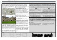
The North Gate with the adjoining prison of Bocardo stood on Cornmarket Street and<br />
was destroyed in 1772. Towers stood to the east and west of the gateway, which had<br />
two storeys. To the north, was an open barbican and two rounded towers projecting<br />
beyond it. Parts of the gate have been seen in excavations in the 20th century (UAD<br />
48, 408). The Bocardo prison extended over the gate: both are depicted in a drawing<br />
by John Malchair in 1771 (UAD6 3).<br />
Eastgate<br />
The late <strong>medieval</strong> Eastgate was located on the High Street at the junction with<br />
Longwall Street. Salter’s survey of <strong>Oxford</strong> notes there were five tenements within the<br />
gate itself prior to its demolition in 1771 (Salter 1955a: 197). The gate has not been<br />
recorded archaeologically, though 18th-century drawings show it in its rebuilt state<br />
with a simple arch across the street.<br />
Littlegate<br />
The Littlegate, originally the Water Gate, breached the <strong>City</strong> Wall at the north end of<br />
Littlegate Street, on a line with Brewer Street. It had two arches, one for pedestrians<br />
and one for carts, with rooms above. The pedestrian arch survived until 1798 and<br />
fragments were seen in the redevelopment work in 1971 (Hassall, Halpin and Mellor<br />
1989). The gate was drawn by Malchair (Harrison 1998: Fig 12).<br />
Southgate<br />
The Southgate stood in St Aldates level with the north side of Brewer Street (RCHME<br />
1939: 161). The gate had disappeared by the early 17th century, possibly having<br />
been partly demolished when Cardinal College was built in the 16th century. It is said<br />
to have had a vaulted tunnel with flanking towers, one of which was leased to St<br />
Michael's Church (Sturdy 1961-2: 23). In 2008, a watching brief in St Aldates noted<br />
re-deposited ashlar stone blocks opposite Brewer Street that may have been<br />
demolition debris from the Southgate or the town wall (Sims 2008).<br />
Smith Gate and Westgate<br />
Smithgate stood across Catte Street immediately to the west of the chapel of Our<br />
Lady which is mentioned in the 14th century (VCH iv: 406). Little is known about the<br />
Saxon Westgate. Following the construction of the Castle, the Westgate was located<br />
at the junction of Church Street and Castle Street as shown on Agas’ 16th century<br />
map of the city. It was demolished in the 17th century (UAD Monument 437).<br />
OXFORD ARCHAEOLOGICAL RESOURCE ASSESSMENT- POST MEDIEVAL<br />
57