Post-medieval Oxford - Oxford City Council
Post-medieval Oxford - Oxford City Council
Post-medieval Oxford - Oxford City Council

You also want an ePaper? Increase the reach of your titles
YUMPU automatically turns print PDFs into web optimized ePapers that Google loves.
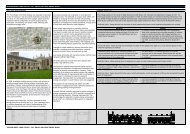
Headington Quarry<br />
The parish has long been known for its important stone quarries from which much of<br />
the stone for the university buildings came (Mason 1989: 363). By the 16 th century,<br />
Headington Quarry was recognised as a hamlet of the main village and cottages<br />
were frequently added to the hamlet without licence (ibid). The quarries were at their<br />
most productive in the 17 th and into the 18 th centuries as a result of major building<br />
schemes within the city. The turnpiking of the road from <strong>Oxford</strong> to London via<br />
Shotover in 1718 further improved access to the quarries and in consequence,<br />
improved their productivity (Mason 1989: 364). Cartographic sources from the 18 th<br />
century at least record settlement at Headington Quarry and by this point it is<br />
afforded separate status to that at Headington. An overview of the map evidence for<br />
Headington Quarry and historic summary is provided by Arkell (1947).<br />
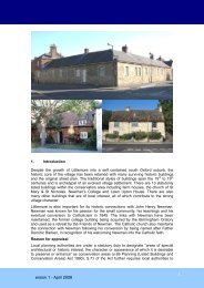
Iffley<br />
Iffley is a linear village formed on the banks of the River Thames and at the base of<br />
Rose Hill. The southern end of the village comprises the 12 th century church and the<br />
13 th century Vicarage with extensive 16 th century extensions. There are several listed<br />
post-<strong>medieval</strong> domestic structures along the village’s main street as it follows the<br />
base of the hill to its northern extent on Henley Avenue. The core of the village<br />
survives well despite intensive modern development along its periphery.<br />
Littlemore<br />
Littlemore Priory was held by Christ Church until the mid 17 th century when it was<br />
granted to the Powell family with whom it remained until the 18 th century. Excavations<br />
to the east of the priory between 1996 and 2001 have revealed evidence of its<br />
continued use as a farmhouse throughout the post-<strong>medieval</strong> period (RPS 2001: 10).<br />
A single structure thought to have been an agricultural building comprising stone and<br />
brick walling was recorded in the western part of the site closest to the former priory.<br />
Several tracks and roads were also recorded during the investigations as well pits<br />
containing domestic and building waste (ibid.).<br />
Marston<br />
The village of Marston lies to the north-east of <strong>Oxford</strong> adjacent to the River Cherwell.<br />
Access to the village was through the main road – now the <strong>Oxford</strong> Road and via<br />
Marston Ferry across the river. An estate map of Marston from 1601 indicates a<br />
mixture of agricultural use around the village with arable fields to the north, west and<br />
south of the village, meadowland along the river and commons and marshes to the<br />
east. The map also illustrates the village as a linear settlement along the main road<br />
with irregular plots fronting onto the main road, many of which survived into the 19 th<br />
century at least, while some have been retained in the modern village.<br />
Archaeological investigations at the White Hart, <strong>Oxford</strong> Road in 2002 recorded<br />
evidence of a post-<strong>medieval</strong> outbuilding of a probable 18 th century date (Hiller 2002:<br />
7). The 1601 map of the village indicates the plot for the White Hart dates back to<br />
17 th century at least, with a range of structures fronting onto the road. The 17 th<br />
century White Hart in Old Marston has also been subject to a building survey (<strong>Oxford</strong><br />
Archaeological Unit 2001b).<br />
St Clements<br />
St Clements, although essentially a suburb of the city by the post-<strong>medieval</strong> period,<br />
was not officially annexed until the mid 19 th century. The extensive redevelopment of<br />
the area in the late 18 th century as a result of the Mileways Act removed much of the<br />
pre-1771 settlement (Lobel 1957: 259). An archaeological watching brief during<br />
OXFORD ARCHAEOLOGICAL RESOURCE ASSESSMENT- POST MEDIEVAL<br />
22