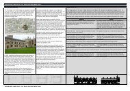
Post-medieval Oxford - Oxford City Council
Post-medieval Oxford - Oxford City Council
Post-medieval Oxford - Oxford City Council

Create successful ePaper yourself
Turn your PDF publications into a flip-book with our unique Google optimized e-Paper software.
illustrates a more intensively developed area. The college now possessed more<br />
formal garden designs while the adjacent domestic structures appear to comprise<br />
extensive ranges of buildings. The High Street itself is much wider at this point and it<br />
would appear the detached structures on the south side had been demolished and<br />
partially replaced with a series of domestic tenements with a substantial area of<br />
market gardens to the rear along the east wall of the city. The Botanic Gardens now<br />
occupied the space adjacent to the river.<br />
Limited archaeological evidence has come from the grounds of the Gardens<br />
comprising a 17th century low stone wall in 1954 (UAD 162), and a clay pipe in 1958<br />
(UAD 1313). Several archaeological investigations in the garden and deer park to the<br />
rear of Magdalen College have recovered miscellaneous finds and fragmentary<br />
features including ceramic wig curlers, (UAD 782), iron candlesticks, (UAD 1176),<br />
and a substantial ditch that may have formed part of the Civil War defences along<br />
with 17th century domestic waste (UAD 478), and a stone wall of a probable post<strong>medieval</strong><br />
date (UAD 582). Excavations at Longwall Quad in 1995 recorded a<br />
substantial post-<strong>medieval</strong> pottery assemblage that may have been associated with<br />
the tenements fronting onto Longwall Street, (Roberts 1999: 284). On the south side<br />
of High Street, a 2010 evaluation in the car park of the Eastgate Hotel, indicated a<br />
hiatus between 13th-14th century pit digging and activity in the mid- to late 17th<br />
century when a single storey building or buildings were erected. The walls were<br />
robbed in the later 17th or 18th centuries and a layer of soil was imported raising the<br />
ground level by c. 0.5m (Cotswold Archaeology 2011).<br />
The southern suburbs<br />
The southern suburbs from Christ Church to the River Thames are illustrated on the<br />
Agas’ map as a series of plots fronting onto St Aldates with the Trill Mill Stream<br />
enclosing them to the east, Christ Church Meadow beyond and a second,<br />
(Blackfriars), stream to the west with the former lands of the Blackfriars and the<br />
Greyfriars behind.<br />
As noted above, garden soils have been recorded overlying the <strong>medieval</strong> Greyfriars<br />
at Paradise Square (UAD 315; 539), the buildings having been largely destroyed<br />
following the Dissolution, (Hassall and Halpin et al. 1984:173). The Greyfriars site<br />
was divided by 1544 and the <strong>City</strong> Wall became a property boundary, (ibid.: 175).<br />
Substantial quarrying was recorded during excavations at the Greyfriars site which<br />
was sufficient to destabilise the <strong>City</strong> Wall and necessitate the rebuilding of a less<br />
substantial property boundary, although there was no evidence for new structures<br />
until the 19th century.<br />
Archaeological investigations on St Aldates since the 1970s have indicated continued<br />
occupation since the 12th century at least, with little development beyond the<br />
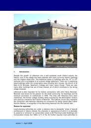
established tenements (Durham 1977: 89). A building survey of 89-91 St Aldates<br />
prior to demolition recorded the two storey 17th century house, with timber frame and<br />
stone front and side walls. The roof had been removed when another floor was<br />
added in the late 18th or early 19th century. The house had been refronted and refenistrated<br />
in the 18th century (Wilkinson in Dodd ed. 2003: 101-2). An example of a<br />
plain vernacular 16th or 17th timber framed rear (kitchen or service) wing was subject<br />
to building recording at 84 St Aldates in 1991 (Munby 1991).<br />
The western suburbs<br />
Agas’ 1578 map illustrates tenement development along St Thomas’ High Street,<br />
(then the main road out of the city), Holybush Row and The Hamel, with long narrow<br />
tenement plots some 80 metres in length. Loggan’s map of 1675 shows a similar<br />
OXFORD ARCHAEOLOGICAL RESOURCE ASSESSMENT- POST MEDIEVAL<br />
18