CONSERVATION AREA STATEMENT - Stroud District Council
CONSERVATION AREA STATEMENT - Stroud District Council CONSERVATION AREA STATEMENT - Stroud District Council
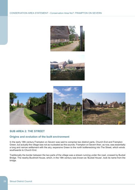
26 CONSERVATION AREA STATEMENT - Conservation Area No7: FRAMPTON ON SEVERN SUB AREA 2: THE STREET Origins and evolution of the built environment In the early 18th century Frampton on Severn was said to comprise two distinct parts, Church End and Frampton Green, but actually the village was not as nucleated as this sounds. Frampton on Severn then, as now, was essentially a long and narrow settlement with the airy, expansive Green to the north bottlenecking into The Street, which winds southwards to Church End. Traditionally the border between the two parts of the village was a stream running under the road, crossed by Buckel Bridge. The nearby Buckholt House, which, in the 19th century was known as ‘Buckel House’, took its name from the bridge. Stroud District Council
There were already houses lining the Street by the 15th century, the majority of which were north of the stream. One of the Street’s notable features is that, although most houses have been built parallel to the road, others are at right angles. It has been hypothesised that this is a throw back to medieval times, when the lord of the manor granted the inhabitants of Frampton strips of land, called ‘tenure strips’. It is believed that those who held wide plots of multiple strips preferred to build parallel to the road, whilst those who were constrained by a narrow, single strip plot could only build their houses end-on. This pattern of development has been preserved and perpetuated, as can be demonstrated by Falfield Cottage and Harts Cottages, among others. The Street now comprises a parade of generally modest- sized buildings that encompasses over 500 years of architectural evolution- the timber framing of the 15th century is juxtaposed with progressively modern design; vernacular 17th century brick cottages sit up against self-conscious 18th century elegance, which in turn rubs shoulders with 19th century workaday terraces and 20th century standard build. Uses CONSERVATION AREA STATEMENT - Conservation Area No7: FRAMPTON ON SEVERN The Street has always been predominately residential, however, once it also held several shops and businesses, including a bakery, a butcher’s, a blacksmith’s, a boot maker, and a candle maker, as well as a post office. The schoolhouse was also in The Street. This was the National School, built in 1842 for the Church of England from grants supplied by The National Society for the Education of the Poor in the Principles of the Established Church. The Vicarage was built close by. Stroud District Council 27
- Page 1: CONSERVATION AREA STATEMENT - Conse
- Page 4 and 5: CONSERVATION AREA STATEMENT - Conse
- Page 6 and 7: 6 CONSERVATION AREA STATEMENT - Con
- Page 8 and 9: 8 CONSERVATION AREA STATEMENT - Con
- Page 10 and 11: 10 CONSERVATION AREA STATEMENT - Co
- Page 12 and 13: 12 CONSERVATION AREA STATEMENT - Co
- Page 14 and 15: 14 CONSERVATION AREA STATEMENT - Co
- Page 16 and 17: 16 CONSERVATION AREA STATEMENT - Co
- Page 18 and 19: 18 CONSERVATION AREA STATEMENT - Co
- Page 20 and 21: 20 CONSERVATION AREA STATEMENT - Co
- Page 22 and 23: 22 CONSERVATION AREA STATEMENT - Co
- Page 24 and 25: 24 CONSERVATION AREA STATEMENT - Co
- Page 28 and 29: 28 CONSERVATION AREA STATEMENT - Co
- Page 30 and 31: 30 CONSERVATION AREA STATEMENT - Co
- Page 32 and 33: 32 CONSERVATION AREA STATEMENT - Co
- Page 34 and 35: 34 CONSERVATION AREA STATEMENT - Co
- Page 36 and 37: 36 CONSERVATION AREA STATEMENT - Co
- Page 38 and 39: 38 CONSERVATION AREA STATEMENT - Co
- Page 40 and 41: 40 CONSERVATION AREA STATEMENT - Co
- Page 42 and 43: 42 CONSERVATION AREA STATEMENT - Co
- Page 44 and 45: 44 CONSERVATION AREA STATEMENT - Co
- Page 46 and 47: 46 CONSERVATION AREA STATEMENT - Co
- Page 48 and 49: 48 CONSERVATION AREA STATEMENT - Co
- Page 50 and 51: 50 CONSERVATION AREA STATEMENT - Co
- Page 52 and 53: 52 CONSERVATION AREA STATEMENT - Co
- Page 54 and 55: 54 CONSERVATION AREA STATEMENT - Co
- Page 56 and 57: 56 CONSERVATION AREA STATEMENT - Co
- Page 58 and 59: 58 CONSERVATION AREA STATEMENT - Co
- Page 60 and 61: 60 CONSERVATION AREA STATEMENT - Co
- Page 62 and 63: 62 CONSERVATION AREA STATEMENT - Co
- Page 64 and 65: 64 CONSERVATION AREA STATEMENT - Co
- Page 66 and 67: 66 CONSERVATION AREA STATEMENT - Co
- Page 68 and 69: 68 CONSERVATION AREA STATEMENT - Co
- Page 70 and 71: 70 CONSERVATION AREA STATEMENT - Co
- Page 72 and 73: 72 CONSERVATION AREA STATEMENT - Co
- Page 74 and 75: 74 CONSERVATION AREA STATEMENT - Co
26<br />
<strong>CONSERVATION</strong> <strong>AREA</strong> <strong>STATEMENT</strong> - Conservation Area No7: FRAMPTON ON SEVERN<br />
SUB <strong>AREA</strong> 2: THE STREET<br />
Origins and evolution of the built environment<br />
In the early 18th century Frampton on Severn was said to comprise two distinct parts, Church End and Frampton<br />
Green, but actually the village was not as nucleated as this sounds. Frampton on Severn then, as now, was essentially<br />
a long and narrow settlement with the airy, expansive Green to the north bottlenecking into The Street, which winds<br />
southwards to Church End.<br />
Traditionally the border between the two parts of the village was a stream running under the road, crossed by Buckel<br />
Bridge. The nearby Buckholt House, which, in the 19th century was known as ‘Buckel House’, took its name from the<br />
bridge.<br />
<strong>Stroud</strong> <strong>District</strong> <strong>Council</strong>


