CONSERVATION AREA STATEMENT - Stroud District Council
CONSERVATION AREA STATEMENT - Stroud District Council
CONSERVATION AREA STATEMENT - Stroud District Council

You also want an ePaper? Increase the reach of your titles
YUMPU automatically turns print PDFs into web optimized ePapers that Google loves.
Open space takes seven main forms within this sub-area:<br />
The churchyard<br />
Private gardens<br />
Farmyards<br />
Roads and lanes<br />
‘islands’ of grass<br />
Fields and orchards<br />
‘scrubby’ ground<br />
<strong>CONSERVATION</strong> <strong>AREA</strong> <strong>STATEMENT</strong> - Conservation Area No7: FRAMPTON ON SEVERN<br />
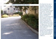
In many respects Church End retains its medieval form, with the settlement clustered around the church. Even though<br />
there are modern farm, industrial and domestic buildings, this part of Frampton seems to be almost timeless.<br />
A significant contribution to this is the lack of any kind of road markings and a minimal amount of signage. The lack<br />
of highways intervention encourages pedestrians to wander along the road, rather than to keep to one side. Cars are<br />
few and far between, and easily spotted along the straight stretch to the canal or as they slow to come around the<br />
corner from The Street.<br />
The area immediately surrounding the church has a tidy appearance, though not municipally so, with well tended<br />
verges and islands of grass breaking up what is actually quite a wide road area. One of Frampton’s many orchards<br />
ensures that the natural environment comes into the manicured. The bench sited on one of the grassy islands outside<br />
Tanhouse Barn provides a place to stop and enjoy the sight of the sheep keeping the grass down in the fields.<br />
The jumble of gardens are demarcated by iron railings and hedges and brick walls of differing heights. In places, the<br />
taller brick walls and hedges are quite overbearing, creating very impermeable hard edges to lanes, narrowing the<br />
spaces down; at other points, the low walls and hedges allow open peeks into the cottage gardens, and into the<br />
orchards and meadows and even down to the canal. Church End is made up of the juxtaposition of open areas and<br />
constrictive bottlenecks.<br />
Unfortunately, some non-traditional, overly suburban, boundary treatments have begun to erode Church End’s<br />
character. However, the overall effect is still naturalistic; picture post card, without being twee.<br />
The two farmyards in the sub- area have very different appearances. Part of the Tanhouse Farm complex has been<br />
converted into residential accommodation and has been neatened up and ‘sanitised’. Denfurlong Farm, by contrast<br />
is still in agricultural use, its busy yard still fully employed. Workaday, no- frills, modern materials, such as corrugated<br />
iron roofing, have helped keep the old farmyard buildings fit for purpose. It is one of the few reminders of Church<br />
End’s functional past- the industrial units adjacent to Tanhouse Farm on the lane to Splatt Bridge, do not seem to<br />
make any similarly ‘gritty’ contribution to the area.<br />
One of the more important spaces within the sub- area is the wild piece of land at the bottom of The Street. This gap<br />
marks the separation between The Street and the enclave of Church End. The views afforded across to the back of<br />
Tanhouse Farm (formerly including the manor house) and the church are a glimpse into the very heart of medieval<br />
Frampton.<br />
<strong>Stroud</strong> <strong>District</strong> <strong>Council</strong><br />
25