Geologic Maps and Cross Sections
Geologic Maps and Cross Sections
Geologic Maps and Cross Sections

You also want an ePaper? Increase the reach of your titles
YUMPU automatically turns print PDFs into web optimized ePapers that Google loves.
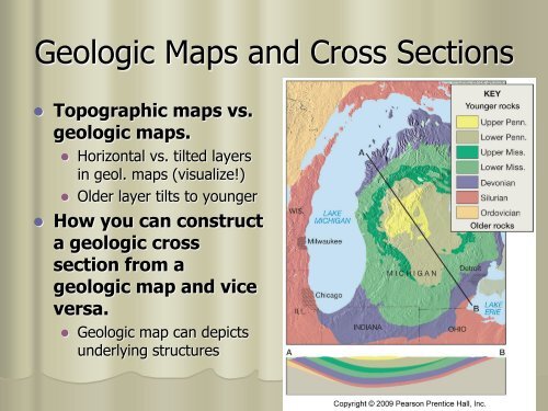
<strong>Geologic</strong> <strong>Maps</strong> <strong>and</strong> <strong>Cross</strong> <strong>Sections</strong><br />
Topographic maps vs.<br />
geologic maps.<br />
Horizontal vs. tilted layers<br />
in geol. maps (visualize!)<br />
Older layer tilts to younger<br />
How you can construct<br />
a geologic cross<br />
section from a<br />
geologic map <strong>and</strong> vice<br />
versa.<br />
<strong>Geologic</strong> map can depicts<br />
underlying structures
<strong>Geologic</strong> Structures<br />
Types of stress <strong>and</strong> resulting structures:<br />
Compressional, tensional, <strong>and</strong> shear<br />
Folding (ductile) vs. faulting (brittle rocks)<br />
What are three components of attitude or<br />
orientation of a layer?<br />
Make sure to adjust for magnetic declination of compass<br />
Strike<br />
Compass direction of a horizontal line on bedding<br />
plane (following the “Right Rule” – i.e. dips to right)<br />
Dip direction<br />
perpendicular to strike direction<br />
Dip angle<br />
actual amount of tilt of the layer<br />
30 0
Crustal Deformation - Foldings<br />
How do folds form?<br />
(Geoscience animation CD)<br />
Tectonics proposes,<br />
erosion disposes<br />
Difference between:<br />
Anticline (older rocks<br />
in center)<br />
Syncline (younger<br />
rocks in center)<br />
Monocline<br />
in terms of their<br />
attitudes shown on<br />
map <strong>and</strong> cross<br />
sections.
Special Types of Foldings
Special Folds<br />
Asymmetric vs. symmetric folds<br />
Plunging folds<br />
recumbent folds<br />
Overturned folds<br />
Topographic hill – structural syncline<br />
Topographic valley – structural<br />
anticline (like in central PA)
Crustal Deformation: Faults<br />
How do faults form?<br />
(Geoscience animation CD)<br />
What elements are<br />
needed to determine<br />
the difference<br />
between a normal <strong>and</strong><br />
reverse fault?<br />
Hanging wall & footwall<br />
Upthrown &<br />
downthrown blocks
Normal vs. Reverse Faults<br />
Footwall Upthrown =<br />
Normal (FUN)<br />
Footwall Downthrown<br />
= Reverse (FDR)<br />
Same layer reverses<br />
within fault plane<br />
Upthrown<br />
Upthrown<br />
Downthrown<br />
Downthrown
Special Types of Faults<br />
Special cases of<br />
folding/faulting?<br />
Thrust fault,<br />
horsts, grabens<br />
(e.g. basin &<br />
ranges),<br />
semi-grabenshaped<br />
rift valleys<br />
(Triassic Rift Valley)
Special Faults (cont’d)<br />
Decollement (in PA)<br />
Thrust faults that are not<br />
connected to layers above<br />
<strong>and</strong> below<br />
Involves long distance<br />
movement (25-100 km)<br />
Almost horizontal<br />
Nappe (in Alps)<br />
Sheet-like allochthonous<br />
layer involving recumbent<br />
fold & thrust fault<br />
Klippe (Hamburg, PA)<br />
Erosional remnant of a<br />
thrust fault (outlier of a<br />
nappe)
<strong>Cross</strong> Section of PA<br />
Valley <strong>and</strong> Ridge folded by Africa pushing<br />
into North America<br />
Substantial horizontal movement (~100 km)
Red layer is<br />
eroded<br />
Up<br />
Faults on <strong>Geologic</strong> <strong>Maps</strong><br />
2<br />
2 3<br />
1<br />
2<br />
1<br />
Fault trace on<br />
horizontal layers<br />
3<br />
Down<br />
Map View<br />
<strong>Cross</strong> Section<br />
Upthrown block places<br />
older rocks (layer 2)<br />
against younger rocks<br />
(layer 3) at the same<br />
elevation (on surface)<br />
Let’s say, the layers<br />
are horizontal both on<br />
map <strong>and</strong> in X-section.<br />
What does the<br />
geologic map (on left)<br />
tell you about the<br />
structure (fold, fault,<br />
intrusion)?<br />
What type of fault is<br />
it?
Faults in <strong>Geologic</strong> <strong>Maps</strong><br />
How can you recognize<br />
titled & faults in a geologic<br />
map?<br />
Need to determine dip of fault<br />
plane, which points to hanging<br />
wall<br />
When st<strong>and</strong> astride a fault<br />
trace on a map; older rocks<br />
are on upthrown block<br />
Upthrown rocks are eroded<br />
down over time<br />
Position of tilted rocks shifts<br />
with erosion<br />
What type of fault is it?<br />
Why is this not a transform<br />
fault?<br />
Oldest =1<br />
2<br />
Upthrown=old<br />
3<br />
4=youngest<br />
Footwall<br />
Upthrown<br />
Fault Trace<br />
Hanging Wall<br />
Downthrown<br />
<strong>Geologic</strong> map of titled/faulted layers<br />
3<br />
4<br />
2<br />
young<br />
Hanging wall
Oldest =1<br />
2<br />
3<br />
4=youngest<br />
Footwall<br />
Upthrown<br />
Fault Trace<br />
3<br />
4<br />
2<br />
Hanging Wall<br />
Downthrown<br />
Questions?<br />
How will a cross<br />
sections (looking at<br />
the left side <strong>and</strong> at<br />
the front side) of this<br />
geologic map look<br />
like?<br />
Draw two sketches<br />
<strong>and</strong> h<strong>and</strong>ed them to<br />
me with your name<br />
on it.
Strike Slip Fault (Transform)<br />
How do left-lateral<br />
<strong>and</strong> right-lateral<br />
strike-slip faults<br />
vary from each<br />
other.<br />
Transform faults cuts<br />
through lithosphere<br />
Fault plane is vertical<br />
(i.e. no footwall,<br />
hanging wall,<br />
upthrown or<br />
downthrown blocks))
Let’s pay<br />
attention<br />
to the<br />
marked<br />
areas<br />
Example <strong>Geologic</strong> Map