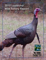
2011-2012 Hunting Regs low-res - Louisiana Department of Wildlife ...
2011-2012 Hunting Regs low-res - Louisiana Department of Wildlife ...
2011-2012 Hunting Regs low-res - Louisiana Department of Wildlife ...

You also want an ePaper? Increase the reach of your titles
YUMPU automatically turns print PDFs into web optimized ePapers that Google loves.
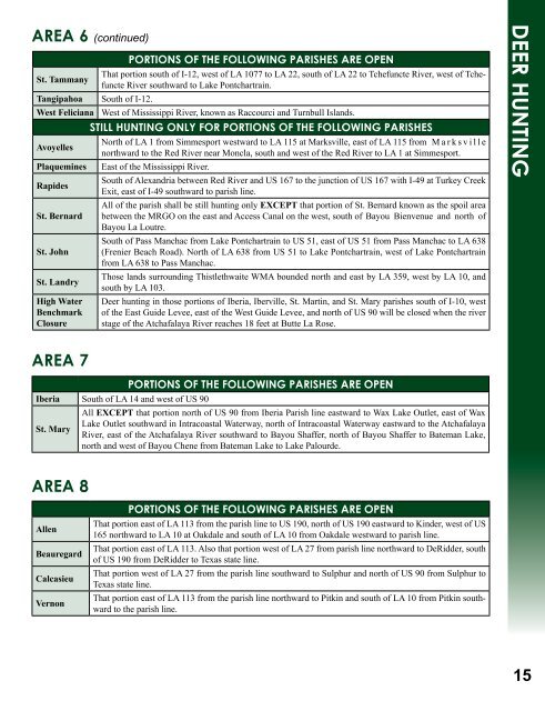
area 6 (continued)<br />
portions <strong>of</strong> the foLLoWing parishes are open<br />
St. Tammany<br />
That portion south <strong>of</strong> I-12, west <strong>of</strong> LA 1077 to LA 22, south <strong>of</strong> LA 22 to Tchefuncte River, west <strong>of</strong> Tchefuncte<br />
River southward to Lake Pontchartrain.<br />
Tangipahoa South <strong>of</strong> I-12.<br />
West Feliciana West <strong>of</strong> Mississippi River, known as Raccourci and Turnbull Islands.<br />
Avoyelles<br />
stiLL hunting onLY for portions <strong>of</strong> the foLLoWing parishes<br />
North <strong>of</strong> LA 1 from Simmesport westward to LA 115 at Marksville, east <strong>of</strong> LA 115 from M a r k s v i l l e<br />
northward to the Red River near Moncla, south and west <strong>of</strong> the Red River to LA 1 at Simmesport.<br />
Plaquemines East <strong>of</strong> the Mississippi River.<br />
Rapides<br />
South <strong>of</strong> Alexandria between Red River and US 167 to the junction <strong>of</strong> US 167 with I-49 at Turkey Creek<br />
Exit, east <strong>of</strong> I-49 southward to parish line.<br />
All <strong>of</strong> the parish shall be still hunting only exCePT that portion <strong>of</strong> St. Bernard known as the spoil area<br />
St. Bernard between the MRGO on the east and Access Canal on the west, south <strong>of</strong> Bayou Bienvenue and north <strong>of</strong><br />
Bayou La Loutre.<br />
South <strong>of</strong> Pass Manchac from Lake Pontchartrain to US 51, east <strong>of</strong> US 51 from Pass Manchac to LA 638<br />
St. John (Frenier Beach Road). North <strong>of</strong> LA 638 from US 51 to Lake Pontchartrain, west <strong>of</strong> Lake Pontchartrain<br />
from LA 638 to Pass Manchac.<br />
St. Landry<br />
Those lands surrounding Thistlethwaite WMA bounded north and east by LA 359, west by LA 10, and<br />
south by LA 103.<br />
High Water<br />
Benchmark<br />
Closure<br />
area 7<br />
Deer hunting in those portions <strong>of</strong> Iberia, Iberville, St. Martin, and St. Mary parishes south <strong>of</strong> I-10, west<br />
<strong>of</strong> the East Guide Levee, east <strong>of</strong> the West Guide Levee, and north <strong>of</strong> US 90 will be closed when the river<br />
stage <strong>of</strong> the Atchafalaya River reaches 18 feet at Butte La Rose.<br />
portions <strong>of</strong> the foLLoWing parishes are open<br />
Iberia South <strong>of</strong> LA 14 and west <strong>of</strong> US 90<br />
All exCePT that portion north <strong>of</strong> US 90 from Iberia Parish line eastward to Wax Lake Outlet, east <strong>of</strong> Wax<br />
Lake Outlet southward in Intracoastal Waterway, north <strong>of</strong> Intracoastal Waterway eastward to the Atchafalaya<br />
St. Mary<br />
River, east <strong>of</strong> the Atchafalaya River southward to Bayou Shaffer, north <strong>of</strong> Bayou Shaffer to Bateman Lake,<br />
north and west <strong>of</strong> Bayou Chene from Bateman Lake to Lake Palourde.<br />
area 8<br />
Allen<br />
Beauregard<br />
Calcasieu<br />
Vernon<br />
portions <strong>of</strong> the foLLoWing parishes are open<br />
That portion east <strong>of</strong> LA 113 from the parish line to US 190, north <strong>of</strong> US 190 eastward to Kinder, west <strong>of</strong> US<br />
165 northward to LA 10 at Oakdale and south <strong>of</strong> LA 10 from Oakdale westward to parish line.<br />
That portion east <strong>of</strong> LA 113. Also that portion west <strong>of</strong> LA 27 from parish line northward to DeRidder, south<br />
<strong>of</strong> US 190 from DeRidder to Texas state line.<br />
That portion west <strong>of</strong> LA 27 from the parish line southward to Sulphur and north <strong>of</strong> US 90 from Sulphur to<br />
Texas state line.<br />
That portion east <strong>of</strong> LA 113 from the parish line northward to Pitkin and south <strong>of</strong> LA 10 from Pitkin southward<br />
to the parish line.<br />
deer hunting<br />
15