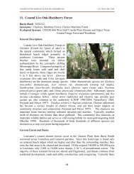
2011-2012 Hunting Regs low-res - Louisiana Department of Wildlife ...
2011-2012 Hunting Regs low-res - Louisiana Department of Wildlife ...
2011-2012 Hunting Regs low-res - Louisiana Department of Wildlife ...

You also want an ePaper? Increase the reach of your titles
YUMPU automatically turns print PDFs into web optimized ePapers that Google loves.
deer hunting<br />
14<br />
area 3 (continued)<br />
portions <strong>of</strong> the foLLoWing parishes are open<br />
Calcasieu<br />
South <strong>of</strong> US 90 from Sulphur to the Texas state line. Also east <strong>of</strong> LA 27 from Sulphur northward to parish<br />
line.<br />
Iberia West <strong>of</strong> US 90 and north <strong>of</strong> LA 14.<br />
Jefferson Davis All exCePT north <strong>of</strong> US 190.<br />
Lafayette West <strong>of</strong> I-49 and US 90.<br />
Rapides<br />
South <strong>of</strong> LA 465 to junction <strong>of</strong> LA 121, west <strong>of</strong> LA 121 and LA 112 to Union Hill and north <strong>of</strong> LA 113<br />
from Union Hill to Vernon Parish line.<br />
St. Landry West <strong>of</strong> US 167.<br />
Vernon<br />
West and north <strong>of</strong> LA 113, south <strong>of</strong> LA 465, east <strong>of</strong> LA 117 from Kurthwood to Leesville, and south <strong>of</strong><br />
LA 8 from Leesville to Texas state line.<br />
area 4<br />
aLL <strong>of</strong> the foLLoWing parishes are open<br />
Richland<br />
portions <strong>of</strong> the foLLoWing parishes are open<br />
east Carroll<br />
West <strong>of</strong> mainline Mississippi River Levee and north and west <strong>of</strong> LA 877 from West Carroll Parish line to<br />
LA 580, north <strong>of</strong> LA 580 to US 65, east <strong>of</strong> US 65 to Madison parish line.<br />
East <strong>of</strong> US 165 (from Arkansas state line) to Bonita, south and east <strong>of</strong> LA 140 to junction <strong>of</strong> LA 830-4<br />
Morehouse<br />
(Cooper Lake Road), east <strong>of</strong> LA 830-4 to Bastrop, east <strong>of</strong> LA 139 at Bastrop to junction <strong>of</strong> LA 593, east<br />
and north <strong>of</strong> LA 593 to Collinston, east <strong>of</strong> LA 138 to junction <strong>of</strong> LA 134 and south <strong>of</strong> LA 134 to Ouachita<br />
Line at Wham Brake.<br />
Ouachita<br />
South <strong>of</strong> US 80 and east <strong>of</strong> Ouachita River, east <strong>of</strong> LA 139 from Sicard to junction <strong>of</strong> LA 134, south <strong>of</strong> LA<br />
134 to Morehouse Parish Line at Wham Brake.<br />
NOTE: For the <strong>2012</strong>-2013 Season, all <strong>of</strong> Area 4 will be combined with Area 1. See Deer <strong>Hunting</strong> Schedule for specifi c dates.<br />
area 5<br />
West Carroll<br />
area 6<br />
aLL <strong>of</strong> the foLLoWing parishes are open<br />
aLL <strong>of</strong> the foLLoWing parishes are open<br />
Ascension, Assumption, Iberville, Jefferson, Lafourche, Orleans, Plaquemines, Pointe Coupee, St. Bernard, St.<br />
Charles, St. James, St. John, St. Martin, Terrebonne and West Baton Rouge<br />
portions <strong>of</strong> the foLLoWing parishes are open<br />
Avoyelles All exCePT that portion west <strong>of</strong> I-49.<br />
evangeline<br />
That portion east <strong>of</strong> I-49 to junction <strong>of</strong> LA 29, east <strong>of</strong> LA 29 south <strong>of</strong> I-49 to Ville Platte and north <strong>of</strong> US<br />
167 east <strong>of</strong> Ville Platte.<br />
Iberia East <strong>of</strong> US 90.<br />
Lafayette East <strong>of</strong> I-49 and US 90.<br />
Livingston South <strong>of</strong> I-12.<br />
Rapides<br />
South <strong>of</strong> Alexandria between Red River and US 167 to the junction <strong>of</strong> US 167 with I-49 at Turkey Creek<br />
Exit, east <strong>of</strong> I-49 southward to parish line.<br />
St. Landry East <strong>of</strong> US 167.<br />
North <strong>of</strong> US 90 from Iberia Parish line eastward to Wax Lake outlet, east <strong>of</strong> Wax Lake outlet southward to<br />
St. Mary<br />
Intracoastal Waterway, north <strong>of</strong> Intracoastal Waterway eastward to the Atchafalaya River, east <strong>of</strong> the Atchafalaya<br />
River southward to Bayou Shaffer, north <strong>of</strong> Bayou Shaffer to Bateman Lake, north and west <strong>of</strong> Bayou<br />
Chene from Bateman Lake to Lake Palourde.