2011-2012 Hunting Regs low-res - Louisiana Department of Wildlife ...
2011-2012 Hunting Regs low-res - Louisiana Department of Wildlife ...
2011-2012 Hunting Regs low-res - Louisiana Department of Wildlife ...
Create successful ePaper yourself
Turn your PDF publications into a flip-book with our unique Google optimized e-Paper software.
Deer HUNTING<br />
12<br />
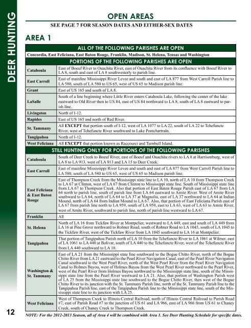
AreA 1<br />
ALL oF THe FoLLoWING PArISHeS Are oPeN<br />
Concordia, East Feliciana, East Baton Rouge, Franklin, Madison, St. Helena, Tensas and Washington<br />
PorTIoNS oF THe FoLLoWING PArISHeS Are oPeN<br />
Catahoula<br />
East <strong>of</strong> Boeuf River to Ouachita River, east <strong>of</strong> Ouachita River from its confl uence with Boeuf River to<br />
LA 8, south and east <strong>of</strong> LA 8 southwesterly to parish line.<br />
East Carroll<br />
East <strong>of</strong> mainline Mississippi River Levee and south and east <strong>of</strong> LA 877 from West Carroll Parish line to<br />
LA 580, south <strong>of</strong> LA 580 to US 65, west <strong>of</strong> US 65 to Madison parish line.<br />
Grant East <strong>of</strong> US 165 and south <strong>of</strong> LA 8.<br />
South <strong>of</strong> a line beginning where Little River enters Catahoula Lake, fol<strong>low</strong>ing the center <strong>of</strong> the lake<br />
LaSalle eastward to Old River then to US 84, east <strong>of</strong> US 84 northward to LA 8, south <strong>of</strong> LA 8 eastward to parish<br />
line.<br />
Livingston North <strong>of</strong> I-12.<br />
Rapides East <strong>of</strong> US 165 and north <strong>of</strong> Red River.<br />
St. Tammany<br />
All EXCEPT that portion south <strong>of</strong> I-12, west <strong>of</strong> LA 1077 to LA 22, south <strong>of</strong> LA 22 to Tchefuncte<br />
River, west <strong>of</strong> Tchefuncte River southward to Lake Pontchartrain.<br />
Tangipahoa North <strong>of</strong> I-12.<br />
West Feliciana All EXCEPT that portion known as Raccourci and Turnbull Island.<br />
Catahoula<br />
STILL HUNTING oNLY For PorTIoNS oF THe FoLLoWING PArISHeS<br />
South <strong>of</strong> Deer Creek to Boeuf River, east <strong>of</strong> Boeuf and Ouachita rivers to LA 8 at Harrisonburg, west <strong>of</strong><br />
LA 8 to LA 913, west <strong>of</strong> LA 913 and LA 15 to Deer Creek.<br />
East Carroll<br />
East <strong>of</strong> mainline Mississippi River Levee and south and east <strong>of</strong> LA 877 from West Carroll Parish line to<br />
LA 580, south <strong>of</strong> LA 580 to US 65, west <strong>of</strong> US 65 to Madison parish line.<br />
East Feliciana<br />
& East Baton<br />
Rouge<br />
East <strong>of</strong> Thompson Creek from the Mississippi state line to LA 10, north <strong>of</strong> LA 10 from Thompson Creek<br />
to LA 67 at Clinton, west <strong>of</strong> LA 67 from Clinton to Mississippi state line. South <strong>of</strong> Mississippi state line<br />
from LA 67 to Thompson Creek. Also that portion <strong>of</strong> East Baton Rouge Parish east <strong>of</strong> LA 67 from LA<br />
64 north to parish line, south <strong>of</strong> parish line from LA 64 eastward to Amite River. West <strong>of</strong> Amite River<br />
southward to LA 64, north <strong>of</strong> LA 64 to LA 37 at Magnolia, east <strong>of</strong> LA 37 northward to LA 64 at Indian<br />
Mound, north <strong>of</strong> LA 64 from Indian Mound to LA 67. Also, that portion <strong>of</strong> East Feliciana Parish east <strong>of</strong><br />
LA 67 from parish line north to LA 959, south <strong>of</strong> LA 959, east to LA 63, west <strong>of</strong> LA 63 to Amite River,<br />
west <strong>of</strong> Amite River, southward to parish line, north <strong>of</strong> parish line westward to LA 67.<br />
Franklin All<br />
North <strong>of</strong> LA 16 from Tickfaw River at Montpelier, westward to LA 449, east and south <strong>of</strong> LA 449 from<br />
St. Helena LA 16 at Pine Grove northward to Rohner Road, south <strong>of</strong> Rohner Road to LA 1045, south <strong>of</strong> LA 1045 to<br />
the Tickfaw River, west <strong>of</strong> the Tickfaw River from LA 1045 southward to LA 16 at Montpelier.<br />
That portion <strong>of</strong> Tangipahoa Parish north <strong>of</strong> LA 10 from the Tchefuncte River to LA 1061 at Wilmer, east<br />
Tangipahoa <strong>of</strong> LA 1061 to LA 440 at Bolivar, south <strong>of</strong> LA 440 to the Tchefuncte River, west <strong>of</strong> the Tchefuncte River<br />
from LA 440 southward to LA 10.<br />
Washington &<br />
St. Tammany<br />
West Feliciana<br />
oPeN AreAS<br />
SEE PAGE 7 FOR SEASOn DATES AnD EITHER-SEX DATES<br />
East <strong>of</strong> LA 21 from the Mississippi state line southward to the Bogue Chitto River, north <strong>of</strong> the Bogue<br />
Chitto River from LA 21 eastward to the Pearl River Navigation Canal, east <strong>of</strong> the Pearl River Navigation<br />
Canal southward to the West Pearl River, north <strong>of</strong> the West Pearl River from the Pearl River Navigation<br />
Canal to Holmes Bayou, west <strong>of</strong> Holmes Bayou from the West Pearl River northward to the Pearl River,<br />
west <strong>of</strong> the Pearl River from Holmes Bayou northward to the Mississippi state line, south <strong>of</strong> the Mississippi<br />
state line from the Pearl River westward to LA 21. Also, that portion <strong>of</strong> Washington Parish west<br />
<strong>of</strong> LA 25 from the Mississippi state line southward to the Bogue Chitto River, then west <strong>of</strong> the Bogue<br />
Chitto River to its junction with the St. Tammany Parish line, north <strong>of</strong> the St. Tammany Parish line to the<br />
Tangipahoa Parish line, east <strong>of</strong> the Tangipahoa Parish line to the Mississippi state line, south <strong>of</strong> the Mississippi<br />
state line to its junction with LA 25.<br />
West <strong>of</strong> Thompson Creek to Illinois-Central Railroad, north <strong>of</strong> Illinois Central Railroad to Parish Road<br />
#7, east <strong>of</strong> Parish Road #7 to the junction <strong>of</strong> US 61 and LA 966, east <strong>of</strong> LA 966 from US 61 to Chaney<br />
Creek, south <strong>of</strong> Chaney Creek to Thompson Creek.<br />
NOTE: For the <strong>2012</strong>-2013 Season, all <strong>of</strong> Area 4 will be combined with Area 1. See Deer <strong>Hunting</strong> Schedule for specifi c dates.


