Optimum Use of the Weather Radar - Airbus
Optimum Use of the Weather Radar - Airbus
Optimum Use of the Weather Radar - Airbus

You also want an ePaper? Increase the reach of your titles
YUMPU automatically turns print PDFs into web optimized ePapers that Google loves.
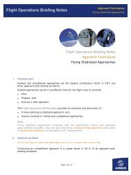
Flight Operations Briefing Notes<br />
I Introduction<br />
Adverse Wea<strong>the</strong>r Operations<br />
<strong>Optimum</strong> <strong>Use</strong> <strong>of</strong> <strong>the</strong> Wea<strong>the</strong>r <strong>Radar</strong><br />
Flight Operations Briefing Notes<br />
Adverse Wea<strong>the</strong>r Operations<br />
<strong>Optimum</strong> <strong>Use</strong> <strong>of</strong> <strong>the</strong> Wea<strong>the</strong>r <strong>Radar</strong><br />
Although more and more aircraft are equipped with one or two airborne wea<strong>the</strong>r<br />
radars, incursions into very active cumulonimbus still occur, resulting in injuries or<br />
substantial aircraft damage (Figure 1).<br />
Figure 1<br />
A320 Radome after Hail Encounter<br />
The aim <strong>of</strong> this Flight Operational Briefing Note is to provide additional information<br />
about wea<strong>the</strong>r radar capabilities and limitations, in order to improve <strong>the</strong> flight crew’s<br />
overall understanding <strong>of</strong> <strong>the</strong> system, and to help prevent such incidents from occurring.<br />
II Background Information - Statistical Data<br />
A wea<strong>the</strong>r radar is only helpful, if <strong>the</strong> flight crew is able to fully use <strong>the</strong> capability <strong>of</strong> <strong>the</strong><br />
system and interpret <strong>the</strong> screen display. The image <strong>of</strong> radar returns on <strong>the</strong> Navigation<br />
Display (ND) is a representation <strong>of</strong> what is detected by <strong>the</strong> radar. Decisions that are<br />
taken, based on this information, will vary depending on <strong>the</strong> flight crew’s interpretation<br />
Page 1 <strong>of</strong> 17
Flight Operations Briefing Notes<br />
Adverse Wea<strong>the</strong>r Operations<br />
<strong>Optimum</strong> <strong>Use</strong> <strong>of</strong> <strong>the</strong> Wea<strong>the</strong>r <strong>Radar</strong><br />
<strong>of</strong> <strong>the</strong> ND radar image, thus on <strong>the</strong> experience <strong>of</strong> <strong>the</strong> flight crew and <strong>the</strong>ir knowledge <strong>of</strong><br />
<strong>the</strong> wea<strong>the</strong>r radar’s limitations.<br />
II.1 Cumulonimbus (Cb) Structure<br />
In flight, cumulonimbus (Cb) structures can be a major source <strong>of</strong> danger, due to<br />
turbulence and heavy precipitation.<br />
Hail<br />
Hail represents a major threat, because <strong>of</strong> its effect and because wea<strong>the</strong>r radar do not<br />
indicate <strong>the</strong> nature <strong>of</strong> returns. Only <strong>the</strong> knowledge <strong>of</strong> a Cb’s structure and <strong>the</strong><br />
observation <strong>of</strong> different clues can help. The presence <strong>of</strong> hail within a Cb, varies with<br />
altitude and wind (Figure 2):<br />
• Below FL 100, hail is equally likely to be encountered under <strong>the</strong> storm, in <strong>the</strong> cloud<br />
or around it (up to 2 NM)<br />
• Between FL 100 and FL 200, 60 percent <strong>of</strong> hail is encountered in <strong>the</strong> Cb and 40<br />
percent is encountered outside <strong>the</strong> cloud, under <strong>the</strong> anvil<br />
• Above FL 200, hail is most likely to be encountered inside <strong>the</strong> cloud.<br />
Usually, <strong>the</strong> threat <strong>of</strong> hail is greater downwind <strong>of</strong> a Cb: indeed, moisture is driven<br />
upward by strong drafts. It <strong>the</strong>n freezes and is transformed into hail, before being<br />
blown downwind. When possible, it is better to try to avoid a storm by flying on <strong>the</strong><br />
upwind side <strong>of</strong> <strong>the</strong> Cb. Paradoxically, <strong>the</strong>re is less risk <strong>of</strong> hail in humid air than in dry<br />
air. In fact, moisture in <strong>the</strong> air behaves as a heat conductor, and helps to melt <strong>the</strong> hail.<br />
Figure 2<br />
The Risk <strong>of</strong> Encountering Hail relative to Cb Cloud Position<br />
Page 2 <strong>of</strong> 17
Flight Operations Briefing Notes<br />
Turbulence<br />
Adverse Wea<strong>the</strong>r Operations<br />
<strong>Optimum</strong> <strong>Use</strong> <strong>of</strong> <strong>the</strong> Wea<strong>the</strong>r <strong>Radar</strong><br />
Turbulence associated with a Cb is not limited to inside <strong>the</strong> cloud. Wea<strong>the</strong>r radars<br />
cannot detect turbulence in clear air, so it is <strong>the</strong>refore necessary to take precautionary<br />
measures. A Cb should be cleared by a minimum <strong>of</strong> 5 000 ft vertically and<br />
20 NM laterally, to minimize <strong>the</strong> risk <strong>of</strong> encountering severe turbulence.<br />
Lightning is a very strong indicator <strong>of</strong> severe turbulence.<br />
Note:<br />
A method to determine <strong>the</strong> altitude <strong>of</strong> <strong>the</strong> top <strong>of</strong> a Cb is presented in paragraph IV.1.<br />
II.2 Wea<strong>the</strong>r <strong>Radar</strong> Principle<br />
A knowledge <strong>of</strong> <strong>the</strong> radar principle is essential in order to accurately interpet<br />
<strong>the</strong> wea<strong>the</strong>r radar display.<br />
Wea<strong>the</strong>r <strong>Radar</strong> Detection Capability<br />
The wea<strong>the</strong>r radar only detects precipitation droplets (Figure 3). How much it detects<br />
depends upon <strong>the</strong> size, composition and number <strong>of</strong> droplets. Water particles are five<br />
times more reflective than ice particles <strong>of</strong> <strong>the</strong> same size.<br />
The radar does detect:<br />
• Rainfall<br />
• Wet hail and wet turbulence<br />
Figure 3<br />
Wea<strong>the</strong>r <strong>Radar</strong> Principle<br />
• Ice crystals, dry hail and dry snow. However, <strong>the</strong>se three elements give small<br />
reflections, as explained below.<br />
The radar does not detect:<br />
• Clouds, fog or wind (droplets are too small, or no precipitation at all)<br />
• Clear air turbulence (no precipitation)<br />
Page 3 <strong>of</strong> 17
Flight Operations Briefing Notes<br />
• Windshear (no precipitation except in microburst)<br />
• Sandstorms (solid particles are almost transparent to <strong>the</strong> radar beam)<br />
• Lightning.<br />
Reflectivity<br />
Adverse Wea<strong>the</strong>r Operations<br />
<strong>Optimum</strong> <strong>Use</strong> <strong>of</strong> <strong>the</strong> Wea<strong>the</strong>r <strong>Radar</strong><br />
<strong>Radar</strong> echo returns are proportional to droplet size, and <strong>the</strong>refore, precipitation<br />
intensity. Droplets that are too small (fog droplets) will return no echo, whereas heavy<br />
droplets (thunderstorm droplets) will return <strong>the</strong> majority <strong>of</strong> radar waves (Figure 4).<br />
Figure 4<br />
Reflectivity According to Droplet Size<br />
Reflectivity <strong>of</strong> precipitation not only depends on <strong>the</strong> intensity <strong>of</strong> <strong>the</strong> precipitation, but<br />
also on <strong>the</strong> type <strong>of</strong> precipitation. Precipitation that contains water will return a stronger<br />
return than dry precipitation. Dry hail, for example, will reflect far less than wet hail<br />
(Figure 5). The upper level <strong>of</strong> a thunderstorm, that contains ice crystals, provides<br />
weaker returns than <strong>the</strong> middle part, that is full <strong>of</strong> water or wet hail.<br />
Figure 5<br />
Reflectivity According to Droplet Type<br />
Page 4 <strong>of</strong> 17
Flight Operations Briefing Notes<br />
Adverse Wea<strong>the</strong>r Operations<br />
<strong>Optimum</strong> <strong>Use</strong> <strong>of</strong> <strong>the</strong> Wea<strong>the</strong>r <strong>Radar</strong><br />
It is important to note that reflectivity <strong>of</strong> particles is not directly proportional to<br />
<strong>the</strong> hazard that may be encountered in a cell. Air can be very humid, when close to <strong>the</strong><br />
sea for instance. In this case, <strong>the</strong>rmal convection will produce clouds that are full <strong>of</strong><br />
water. These clouds will have a high reflectivity, but will not necessarily be a high<br />
threat. On <strong>the</strong> o<strong>the</strong>r hand, <strong>the</strong>re are equatorial overland regions where converging<br />
winds produce large scale uplifts <strong>of</strong> dry air. The resulting wea<strong>the</strong>r cells have much less<br />
reflectivity than mid-latitude convective cells, making <strong>the</strong>m much harder to detect.<br />
However turbulence in or above such clouds may have a higher intensity than indicated<br />
by <strong>the</strong> image on <strong>the</strong> wea<strong>the</strong>r radar display.<br />
Similarly, snow flakes have low reflectivity, as long as <strong>the</strong>y are above freezing level. As<br />
<strong>the</strong>y descend through freezing level, snowflakes stick toge<strong>the</strong>r and become water<br />
covered. Their reflectivity increases and <strong>the</strong> wea<strong>the</strong>r radar display may display amber<br />
or red cells, despite <strong>the</strong> fact that <strong>the</strong>re is no threat.<br />
Attenuation<br />
Because <strong>the</strong> wea<strong>the</strong>r radar display depends on signal returns, heavy precipitation may<br />
conceal even stronger wea<strong>the</strong>r: The major part <strong>of</strong> <strong>the</strong> signal is reflected by <strong>the</strong> frontal<br />
part <strong>of</strong> <strong>the</strong> precipitation. The aft part returns weak signals, that are displayed as green<br />
or black areas. The flight crew may interpret <strong>the</strong>se as a no/small threat areas.<br />
Modern wea<strong>the</strong>r radars are now able to apply a correction to a signal when it is<br />
suspected to have been attenuated behind a cloud. This reduces <strong>the</strong> attenuation<br />
phenomenon. However, a black hole behind a red area on a wea<strong>the</strong>r radar display<br />
should always be considered as a zone that is potentially very active.<br />
Despite this attenuation correction function, <strong>the</strong> wea<strong>the</strong>r radar should not be used as a<br />
tool to penetrate, or navigate around, areas that are displayed as severe. The wea<strong>the</strong>r<br />
radar should only be considered as a tool to be used for wea<strong>the</strong>r avoidance.<br />
Figure 6<br />
Attenuation Behind Two Very Active Cells<br />
Page 5 <strong>of</strong> 17
Flight Operations Briefing Notes<br />
Wea<strong>the</strong>r Shapes that should attract <strong>the</strong> Flight Crew’s Attention<br />
Some displays contain cues that should alert <strong>the</strong> flight crew:<br />
• Shapes<br />
Adverse Wea<strong>the</strong>r Operations<br />
<strong>Optimum</strong> <strong>Use</strong> <strong>of</strong> <strong>the</strong> Wea<strong>the</strong>r <strong>Radar</strong><br />
Shapes, more than colors, should be observed carefully in order to detect adverse<br />
wea<strong>the</strong>r conditions.<br />
Closely spaced areas <strong>of</strong> different colors usually indicate highly turbulent zones<br />
(Figure 7).<br />
Figure 7<br />
Closely Spaced Areas <strong>of</strong> Different Colors<br />
Some shapes are good indicators <strong>of</strong> severe hail and signify strong vertical drafts<br />
(Figure 8). Fast changing shapes, whatever form <strong>the</strong>y take, also indicate high wea<strong>the</strong>r<br />
activity.<br />
Figure 8<br />
Shapes Indicating Adverse Wea<strong>the</strong>r<br />
Page 6 <strong>of</strong> 17
Flight Operations Briefing Notes<br />
Adverse Wea<strong>the</strong>r Operations<br />
<strong>Optimum</strong> <strong>Use</strong> <strong>of</strong> <strong>the</strong> Wea<strong>the</strong>r <strong>Radar</strong><br />
At cruise altitude, ice replaces water in clouds, and ice is not detected as easily as<br />
water by wea<strong>the</strong>r radars. High vertical expansion clouds are representative <strong>of</strong> highenergy<br />
air movements. Therefore, any returns at cruise altitude should be considered<br />
turbulent. In cruise, all cells with green or stronger returns should be avoided by 20 NM<br />
at least.<br />
• Turbulence<br />
Some wea<strong>the</strong>r radars are fitted with a turbulence display mode. This function<br />
(<strong>the</strong> TURB function) is based on <strong>the</strong> Doppler effect and is sensitive to precipitation<br />
movement. Like <strong>the</strong> wea<strong>the</strong>r radar, <strong>the</strong> TURB function needs a minimum amount <strong>of</strong><br />
precipitation to be effective. To help make safe flight path decisions, and especially<br />
when <strong>the</strong> wea<strong>the</strong>r ahead is represented as dense, <strong>the</strong> turbulence display mode should<br />
be used.<br />
An area <strong>of</strong> light rainfall, depicted in green in normal mode, is shown in magenta when<br />
<strong>the</strong>re is high turbulence activity.<br />
The TURB function is only active within a range <strong>of</strong> 40 NM (Doppler measurement<br />
capability) and can only be used in wet turbulence.<br />
Note:<br />
Clear air turbulence and dry turbulence cannot be detected by <strong>the</strong> wea<strong>the</strong>r radar.<br />
III <strong>Radar</strong> Technology<br />
Previous generations <strong>of</strong> wea<strong>the</strong>r radars use parabolic antennae and C-band frequencies<br />
(4 000-8 000 MHz). Newer wea<strong>the</strong>r radars are fitted with flat antennae and use X-Band<br />
(8 000-12 500 MHz) frequencies, that <strong>of</strong>fer <strong>the</strong> following advantages:<br />
• Higher pulse energy<br />
• A narrower beam, that significantly improves <strong>the</strong> target resolution<br />
• Higher reflectivity, and <strong>the</strong>refore a higher total energy return<br />
• Turbulence and windshear detection<br />
• Low power consumption.<br />
Note:<br />
Care should be taken when using radar on ground: <strong>Radar</strong> can cause damage to<br />
<strong>the</strong> human body.<br />
This new technology has higher attenuation, and <strong>the</strong>refore a decreased ability to<br />
determine if <strong>the</strong>re are wea<strong>the</strong>r cells with high levels <strong>of</strong> precipitations. Consequently,<br />
<strong>the</strong> X band radars are intended to be used as wea<strong>the</strong>r avoidance tools and not as tools<br />
for penetrating adverse wea<strong>the</strong>r.<br />
Page 7 <strong>of</strong> 17
Flight Operations Briefing Notes<br />
New generation wea<strong>the</strong>r radars are fitted with:<br />
Adverse Wea<strong>the</strong>r Operations<br />
<strong>Optimum</strong> <strong>Use</strong> <strong>of</strong> <strong>the</strong> Wea<strong>the</strong>r <strong>Radar</strong><br />
• Ei<strong>the</strong>r an auto-tilt function, that will set <strong>the</strong> radar antenna tilt automatically<br />
according to <strong>the</strong> altitude <strong>of</strong> <strong>the</strong> aircraft (see paragraph IV.1)<br />
Figure 1<br />
AutoTilt Function<br />
• Or, an auto-scanning function, that will continuously scan both vertically and<br />
horizontally along <strong>the</strong> aircraft’s intended trajectory, and will store and display<br />
a three-dimensional wea<strong>the</strong>r representation.<br />
Figure 2<br />
Auto-Scanning Function<br />
Page 8 <strong>of</strong> 17
Flight Operations Briefing Notes<br />
IV Operational Standards - Best Practices<br />
Adverse Wea<strong>the</strong>r Operations<br />
<strong>Optimum</strong> <strong>Use</strong> <strong>of</strong> <strong>the</strong> Wea<strong>the</strong>r <strong>Radar</strong><br />
Wea<strong>the</strong>r reports, provided at flight dispatch (e.g. SIGMET), as well as in flight<br />
(e.g. VOLMET, ATIS), inform <strong>the</strong> flight crew <strong>of</strong> potential in-flight wea<strong>the</strong>r. The best way<br />
to use a wea<strong>the</strong>r radar is to use it in conjunction with wea<strong>the</strong>r reports and wea<strong>the</strong>r<br />
forecasts. The wea<strong>the</strong>r radar can <strong>the</strong>n be used in flight to detect, analyze, and to avoid<br />
significant wea<strong>the</strong>r.<br />
The flight crew uses four features to operate <strong>the</strong> radar:<br />
• Antenna tilt, that is <strong>the</strong> angle between <strong>the</strong> centre <strong>of</strong> <strong>the</strong> beam and <strong>the</strong> horizon<br />
• Range control <strong>of</strong> <strong>the</strong> ND, that has an essential influence on <strong>the</strong> optimum tilt setting<br />
• Gain control, that adjusts <strong>the</strong> sensitivity <strong>of</strong> <strong>the</strong> receiver (and should usually be set<br />
to AUTO). The sensitivity <strong>of</strong> <strong>the</strong> receiver may vary from one type <strong>of</strong> radar system to<br />
ano<strong>the</strong>r<br />
• <strong>Radar</strong> modes: wea<strong>the</strong>r (WX), wea<strong>the</strong>r + turbulence (WX + T).<br />
IV.1 Antenna Tilt<br />
On all wea<strong>the</strong>r radars, and more particularly on X-band/flat antenna wea<strong>the</strong>r radars,<br />
effective management <strong>of</strong> <strong>the</strong> antenna tilt, along with adequate selection <strong>of</strong> <strong>the</strong> ND<br />
range, will avoid over/underscanning, thus ensuring optimum detection and<br />
visualization <strong>of</strong> wea<strong>the</strong>r on <strong>the</strong> ND.<br />
Indeed, <strong>the</strong> returns displayed on <strong>the</strong> ND are cells that are cut by <strong>the</strong> radar beam.<br />
The ND does not represent <strong>the</strong> cells at aircraft level. Antenna tilt should be taken into<br />
account in order to clearly understand <strong>the</strong> wea<strong>the</strong>r radar display (Figure 9).<br />
Figure 9<br />
Display along <strong>Radar</strong> Beam<br />
Page 9 <strong>of</strong> 17
Flight Operations Briefing Notes<br />
Adverse Wea<strong>the</strong>r Operations<br />
<strong>Optimum</strong> <strong>Use</strong> <strong>of</strong> <strong>the</strong> Wea<strong>the</strong>r <strong>Radar</strong><br />
When flying towards a cell, <strong>the</strong> flight crew can get an estimate <strong>of</strong> <strong>the</strong> vertical expansion<br />
<strong>of</strong> <strong>the</strong> cloud above/below <strong>the</strong> aircraft altitude with <strong>the</strong> following formula:<br />
h (feet) ~ d(NM) x Tilt (degrees) x 100<br />
Tilt represents <strong>the</strong> tilt selected so that <strong>the</strong> cell image disappears from<br />
<strong>the</strong> display.<br />
For example, an echo disappearing at 40 NM with 1 o tilt down has a top located 4 000 ft<br />
below <strong>the</strong> aircraft level (Figure 10).<br />
Figure 10<br />
Relationship between Distance / Tilt / Height<br />
Antenna tilt should be adapted to <strong>the</strong> ND range selection. In most cases in flight,<br />
<strong>the</strong> adequate antenna tilt setting shows some ground returns at <strong>the</strong> top edge <strong>of</strong><br />
<strong>the</strong> ND. However, at take<strong>of</strong>f, or in climb, <strong>the</strong> tilt should be set up if adverse wea<strong>the</strong>r is<br />
expected above <strong>the</strong> aircraft. The antenna tilt must be adjusted as <strong>the</strong> flight progresses,<br />
in relation to <strong>the</strong> aircraft’s altitude, <strong>the</strong> expected wea<strong>the</strong>r and <strong>the</strong> ND range selection.<br />
In order to avoid overscanning or underscanning, <strong>the</strong> antenna tilt should be changed<br />
periodically when changing altitude, unless <strong>the</strong> wea<strong>the</strong>r radar is fitted with an auto-tilt<br />
function (Figure 11).<br />
Page 10 <strong>of</strong> 17
Flight Operations Briefing Notes<br />
Figure 11<br />
Level Change / Tilt adjustment<br />
Adverse Wea<strong>the</strong>r Operations<br />
<strong>Optimum</strong> <strong>Use</strong> <strong>of</strong> <strong>the</strong> Wea<strong>the</strong>r <strong>Radar</strong><br />
Wea<strong>the</strong>r echoes and ground returns are difficult to differentiate. A change in antenna<br />
tilt rapidly changes <strong>the</strong> shape and color <strong>of</strong> ground returns and eventually causes <strong>the</strong>m<br />
to disappear. This is not <strong>the</strong> case for wea<strong>the</strong>r echoes. Some wea<strong>the</strong>r radars are fitted<br />
with a Ground Clutter Suppress (GCS) function that suppresses <strong>the</strong> ground return from<br />
<strong>the</strong> display, when turned ON.<br />
Upper levels <strong>of</strong> a Cb may contain ice, and <strong>the</strong>refore may return radar images that do<br />
not represent <strong>the</strong> severity <strong>of</strong> its activity. In order to get a better wea<strong>the</strong>r detection,<br />
wea<strong>the</strong>r radar antenna should be pointed toward lower levels, where water can still be<br />
found, i.e. at levels that are below freezing (Figure 12). If a red area is found at<br />
a lower level, <strong>the</strong> antenna tilt should be reduced to scan <strong>the</strong> area vertically. Presence <strong>of</strong><br />
yellow or green areas at higher altitude, above a red cell, is an indication <strong>of</strong> a very<br />
turbulent area.<br />
Figure 12<br />
Storm Scanning<br />
Page 11 <strong>of</strong> 17
Flight Operations Briefing Notes<br />
IV.2 Display Range<br />
IV.3 Gain<br />
Adverse Wea<strong>the</strong>r Operations<br />
<strong>Optimum</strong> <strong>Use</strong> <strong>of</strong> <strong>the</strong> Wea<strong>the</strong>r <strong>Radar</strong><br />
To avoid a large storm, <strong>the</strong> flight crew must make decisions while still 40 NM away<br />
from it. Therefore, <strong>the</strong> flight crew should select adequate ranges on <strong>the</strong> NDs:<br />
• PNF adequate ranges to plan long-term wea<strong>the</strong>r avoidance course changes<br />
(in cruise, typically 160 NM and below)<br />
• PF adequate ranges to tactically avoid adverse wea<strong>the</strong>r, and monitor its severity<br />
(in cruise, typically 80 NM and below).<br />
Course changes to avoid adverse wea<strong>the</strong>r, should be determined using both higher and<br />
lower ranges. This technique prevents <strong>the</strong> “blind alley” effect: A course change that<br />
may seem safe when using a low range ND display may reveal a blocked passage when<br />
observed at a higher range (Figure 13).<br />
Figure 13<br />
Blind Alley Effect<br />
As indicated in paragraph IV.1, antenna tilt should be adapted to range selection.<br />
To cover <strong>the</strong> whole area shown on <strong>the</strong> ND, <strong>the</strong> wea<strong>the</strong>r radar must have a slightly<br />
negative antenna tilt in order to avoid overscanning. A correct setting will show some<br />
ground return at <strong>the</strong> top edge <strong>of</strong> <strong>the</strong> ND.<br />
The GAIN knob on <strong>the</strong> wea<strong>the</strong>r radar panel adjusts <strong>the</strong> receiver sensitivity. In <strong>the</strong> AUTO<br />
position, <strong>the</strong> gain is in <strong>the</strong> optimum position to detect standard thunderstorm cells.<br />
A manual setting is available and can be used to analyze <strong>the</strong> wea<strong>the</strong>r.<br />
Page 12 <strong>of</strong> 17
Flight Operations Briefing Notes<br />
Adverse Wea<strong>the</strong>r Operations<br />
<strong>Optimum</strong> <strong>Use</strong> <strong>of</strong> <strong>the</strong> Wea<strong>the</strong>r <strong>Radar</strong><br />
In general, <strong>the</strong> AUTO position should be used, except for cell evaluation. If gain is used<br />
manually for in-depth wea<strong>the</strong>r analysis, it must be reset to CAL (AUTO) when analysis<br />
is complete.<br />
Gain Reduction<br />
At lower altitudes, cells are more reflective and <strong>the</strong> wea<strong>the</strong>r radar display may have<br />
a tendency to show a lot <strong>of</strong> red spots. This can also be <strong>the</strong> case at higher altitude with<br />
severe Cbs. In this case, decreasing gain:<br />
• Can help to judge <strong>the</strong> relative intensity between two cells<br />
• Can help to highlight turbulent cells, because <strong>the</strong> turbulence display is not affected<br />
by gain in turbulence display mode<br />
• Can be useful for finding embedded cells, in heavy stratus rain<br />
• Can render attenuation more visible, helping to identify very active cells.<br />
Gain reduction allows <strong>the</strong> detection <strong>of</strong> <strong>the</strong> strongest part <strong>of</strong> a cell, displayed in red on<br />
<strong>the</strong> ND. By slowly reducing <strong>the</strong> gain, most red areas slowly turn yellow, <strong>the</strong> yellow<br />
areas turn green and <strong>the</strong> green areas slowly disappear. The remaining red areas,<br />
<strong>the</strong> red areas that are <strong>the</strong> last to turn yellow are <strong>the</strong> strongest parts <strong>of</strong> <strong>the</strong> cell and<br />
must be avoided at <strong>the</strong> greatest distance possible (Figure 14).<br />
Note:<br />
Figure 14<br />
Effect <strong>of</strong> Gain Reduction<br />
In MAP mode, <strong>the</strong> gain should always be reduced because <strong>of</strong> <strong>the</strong> high reflectivity <strong>of</strong><br />
<strong>the</strong> ground.<br />
Page 13 <strong>of</strong> 17
Flight Operations Briefing Notes<br />
Gain Augmentation<br />
Adverse Wea<strong>the</strong>r Operations<br />
<strong>Optimum</strong> <strong>Use</strong> <strong>of</strong> <strong>the</strong> Wea<strong>the</strong>r <strong>Radar</strong><br />
At high altitudes, water particles are frozen and clouds are less reflective. Gain may be<br />
increased for storm evaluation purposes.<br />
V Operational and Human Factors Affecting <strong>Optimum</strong> <strong>Use</strong> <strong>of</strong> Wea<strong>the</strong>r <strong>Radar</strong><br />
The wea<strong>the</strong>r radar display may be wrongly disregarded by <strong>the</strong> flight crew (who may<br />
decide to enter clouds) in <strong>the</strong> following conditions:<br />
• Near <strong>the</strong> destination airport<br />
• When following an o<strong>the</strong>r aircraft<br />
• When more than 15 minutes behind schedule<br />
• At night.<br />
On <strong>the</strong> o<strong>the</strong>r hand, and as explained before, <strong>the</strong> wea<strong>the</strong>r radar, if not correctly used or<br />
interpreted, may mislead <strong>the</strong> flight crew when:<br />
• An area <strong>of</strong> strong activity is hidden behind heavy rain<br />
• A small ND range is not sufficient for <strong>the</strong> flight crew to determine if an elected<br />
trajectory between clouds is blocked by adverse wea<strong>the</strong>r fur<strong>the</strong>r ahead<br />
• Dry hail precipitation returns a weaker echo than water droplets<br />
• The antenna tilt is not correctly adjusted<br />
• Gain is left in a manual position.<br />
VI Prevention Strategies<br />
A wea<strong>the</strong>r radar is a tool for detecting and avoiding adverse wea<strong>the</strong>r and turbulence.<br />
As with any o<strong>the</strong>r tool, adequate skills are needed in order to use it efficiently.<br />
Each type <strong>of</strong> radar has its own particularities, and does not display a given wea<strong>the</strong>r<br />
situation in <strong>the</strong> same way as ano<strong>the</strong>r type <strong>of</strong> wea<strong>the</strong>r radar. These particularities are<br />
outlined in <strong>the</strong> wea<strong>the</strong>r radar user guide. It is <strong>the</strong>refore necessary to study <strong>the</strong><br />
manufacturer’s user guide, in order to gain a good knowledge <strong>of</strong> <strong>the</strong> wea<strong>the</strong>r radar<br />
capabilities and limitations.<br />
The shape <strong>of</strong> radar echoes, as well as <strong>the</strong>ir color, should be observed to identify storms<br />
containing hail. The gain function should be used for deeper analysis, but should <strong>the</strong>n<br />
be reset to <strong>the</strong> CAL or AUTO position. The TURB function can be used when closing in<br />
on active wea<strong>the</strong>r to identify <strong>the</strong> most turbulent area.<br />
The flight crew should periodically scan:<br />
• Vertically, using <strong>the</strong> antenna tilt function<br />
• Horizontally, using <strong>the</strong> range change.<br />
Page 14 <strong>of</strong> 17
Flight Operations Briefing Notes<br />
As a general rule, <strong>the</strong> following prevention strategies apply:<br />
• <strong>Use</strong> <strong>the</strong> wea<strong>the</strong>r radar to detect/analyze/avoid significant wea<strong>the</strong>r<br />
Adverse Wea<strong>the</strong>r Operations<br />
<strong>Optimum</strong> <strong>Use</strong> <strong>of</strong> <strong>the</strong> Wea<strong>the</strong>r <strong>Radar</strong><br />
• The shape/colour/size <strong>of</strong> returns are factors that should be considered to interpret<br />
<strong>the</strong> wea<strong>the</strong>r<br />
• Effective management <strong>of</strong> <strong>the</strong> antenna tilt along with an appropriate ND range<br />
selection, are key tools to obtaining an informative wea<strong>the</strong>r radar display on <strong>the</strong> ND<br />
• Gain is used in CAL/AUTO mode for detection and initial evaluation <strong>of</strong> displayed<br />
wea<strong>the</strong>r: Manual gain control is used to analyze <strong>the</strong> wea<strong>the</strong>r<br />
• Wet turbulence can be detected up to 40 NM with <strong>the</strong> TURB function.<br />
Page 15 <strong>of</strong> 17
Flight Operations Briefing Notes<br />
Adverse Wea<strong>the</strong>r Operations<br />
<strong>Optimum</strong> <strong>Use</strong> <strong>of</strong> <strong>the</strong> Wea<strong>the</strong>r <strong>Radar</strong><br />
Airlines should provide information and recommendations on <strong>the</strong> use <strong>of</strong> radar to <strong>the</strong>ir<br />
flight crews for each flight phase. A typical example <strong>of</strong> recommendations that could be<br />
provided, for radars not fitted with auto-tilt or auto-scanning function, is as follows:<br />
Phase Recommendations Remarks<br />
Taxi<br />
Take<strong>of</strong>f<br />
Climb<br />
Cruise<br />
Descent<br />
Set ND to 10 NM range<br />
Tilt down, <strong>the</strong>n up: Check appearance / disappearance<br />
<strong>of</strong> ground returns<br />
Scan up to 15° UP for wea<strong>the</strong>r return, if significant<br />
wea<strong>the</strong>r is suspected<br />
Select tilt at 4° UP for take<strong>of</strong>f<br />
Select negative tilt, maintain ground returns on top <strong>of</strong><br />
ND as <strong>the</strong> aircraft climbs<br />
Select negative tilt and maintain ground returns on top<br />
<strong>of</strong> ND. As a rule <strong>of</strong> thumb:<br />
Range 320: tilt 1 DN<br />
Range 160: tilt 1.5 DN<br />
Range 80: tilt 3.5 DN<br />
Range 40: tilt 6 DN<br />
When approaching wea<strong>the</strong>r:<br />
- Decrease ND range<br />
- Tilt down<br />
- <strong>Use</strong> TURB to isolate turbulence<br />
- GAIN to AUTO<br />
Above FL150<br />
Every 10 000 ft: Adjust tilt upward to maintain ground<br />
returns on top <strong>of</strong> ND (~ +1 o /10 000 ft)<br />
Below FL150<br />
Every 5 000 ft: Adjust tilt upward to maintain ground<br />
returns on top <strong>of</strong> ND (~ +1 o /5 000 ft)<br />
<strong>Radar</strong> check must be<br />
performed away from<br />
people<br />
Scan along <strong>the</strong> departure<br />
path<br />
Change tilt according to<br />
altitude and ND range.<br />
No ground returns<br />
beyond line <strong>of</strong> sight<br />
FL370 => 240 NM<br />
FL250 => 200 NM<br />
Approach Select tilt at 4° UP To avoid ground returns<br />
Page 16 <strong>of</strong> 17
Flight Operations Briefing Notes<br />
VII Summary <strong>of</strong> Key Points<br />
The following key points should be emphasized:<br />
Adverse Wea<strong>the</strong>r Operations<br />
<strong>Optimum</strong> <strong>Use</strong> <strong>of</strong> <strong>the</strong> Wea<strong>the</strong>r <strong>Radar</strong><br />
• Wea<strong>the</strong>r radars are designed for active detection <strong>of</strong> adverse wea<strong>the</strong>r conditions<br />
• Antenna tilt, range management and gain function need to be fully understood to<br />
use <strong>the</strong> wea<strong>the</strong>r radar effectively<br />
• <strong>Radar</strong> display colors reflect humidity in <strong>the</strong> air and not necessarily turbulence<br />
intensity: A red cell in a humid atmosphere may be less turbulent than a yellow one<br />
in dry air<br />
• The TURB function should be used to identify <strong>the</strong> most turbulent cells within 40 NM.<br />
VIII <strong>Airbus</strong> References<br />
A310/300-600 Flight Crew Operating Manuals - Procedures and Techniques – Inclement<br />
Wea<strong>the</strong>r Operation –Wea<strong>the</strong>r Avoidance – <strong>Optimum</strong> <strong>Use</strong> <strong>of</strong> Wea<strong>the</strong>r <strong>Radar</strong><br />
A320/330/340 Flight Crew Training Manuals - Supplementary Information – <strong>Use</strong> <strong>of</strong><br />
<strong>Radar</strong><br />
IX Additional Reading Material / Website References<br />
• Honeywell (RDR-4B) <strong>Use</strong>r’s Manual with <strong>Radar</strong> Operating Guidelines<br />
http://www.flwsradar.com/Tech_Lit/Pilots_Guide/Pguide_main.htm<br />
• Rockwell Collins Wea<strong>the</strong>r <strong>Radar</strong> Pilot’s Guide<br />
This FOBN is part <strong>of</strong> a set <strong>of</strong> Flight Operations Briefing Notes that provide an overview <strong>of</strong> <strong>the</strong> applicable standards, flying<br />
techniques and best practices, operational and human factors, suggested company prevention strategies and personal lines<strong>of</strong>-defense<br />
related to major threats and hazards to flight operations safety.<br />
This FOBN is intended to enhance <strong>the</strong> reader's flight safety awareness but it shall not supersede <strong>the</strong> applicable regulations<br />
and <strong>the</strong> <strong>Airbus</strong> or airline's operational documentation; should any deviation appear between this FOBN and <strong>the</strong> <strong>Airbus</strong> or<br />
airline’s AFM / (M)MEL / FCOM / QRH / FCTM, <strong>the</strong> latter shall prevail at all times.<br />
In <strong>the</strong> interest <strong>of</strong> aviation safety, this FOBN may be reproduced in whole or in part - in all media - or translated; any use <strong>of</strong><br />
this FOBN shall not modify its contents or alter an excerpt from its original context. Any commercial use is strictly excluded.<br />
All uses shall credit <strong>Airbus</strong>.<br />
<strong>Airbus</strong> shall have no liability or responsibility for <strong>the</strong> use <strong>of</strong> this FOBN, <strong>the</strong> correctness <strong>of</strong> <strong>the</strong> duplication, adaptation or<br />
translation and for <strong>the</strong> updating and revision <strong>of</strong> any duplicated version.<br />
<strong>Airbus</strong> Customer Services<br />
Flight Operations Support and Services<br />
1 Rond Point Maurice Bellonte - 31707 BLAGNAC CEDEX FRANCE<br />
FOBN Reference : FLT_OPS – ADV_WX – SEQ 07 – REV 02 – FEB. 2007<br />
Page 17 <strong>of</strong> 17