The mid seventeenth century collapse of Iroquoian Ontario:
The mid seventeenth century collapse of Iroquoian Ontario:
The mid seventeenth century collapse of Iroquoian Ontario:

Create successful ePaper yourself
Turn your PDF publications into a flip-book with our unique Google optimized e-Paper software.
M. JackeS<br />
348<br />
Introduction<br />
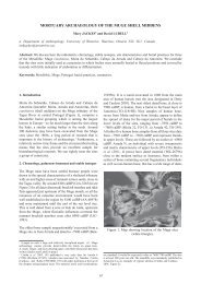
N<br />
0 1 km<br />
Beamers Falls<br />
Forty Mile Creek<br />
<strong>The</strong> cemetery site<br />
Niagara Escarpment<br />
Lake <strong>Ontario</strong><br />
quarry<br />
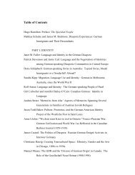
Fig. 1. Sketch map <strong>of</strong> the environs <strong>of</strong> the Grimsby Neutral cemetery.<br />
In 1976, a cemetery <strong>of</strong> the Neutral Nation <strong>of</strong> <strong>Iroquoian</strong> people was discovered in Grimsby,<br />
<strong>Ontario</strong> during preparation for construction <strong>of</strong> a housing development 2 . <strong>The</strong> cemetery lay at<br />
100 metres above sea level, sheltered in an embayment <strong>of</strong> the Niagara Escarpment, and was<br />
dug into a one metre deep sand deposit close to where Forty Mile Creek enters a very narrow<br />
portion <strong>of</strong> the Lake <strong>Ontario</strong> margin, less than 2 km wide (fig. 1). <strong>The</strong> creek descends from<br />
190 metres above sea level via a two-level waterfall <strong>of</strong> an unusual configuration for the<br />
Niagara Escarpment. <strong>The</strong> waterfall forms the major migratory flyway for raptors in the<br />
spring, especially for several species <strong>of</strong> hawks 3 . <strong>The</strong>re is a nearby chert source 4 , but no village<br />
has been found associated with the cemetery. Known Neutral villages lie in the upland flood<br />
plains <strong>of</strong> rivers.<br />
2. <strong>The</strong> cemetery was located in Concession 2, Lot 7, Grimsby Township, Lincoln County, <strong>Ontario</strong> (AhGv-1<br />
is the Borden site designation). When the excavation ended in early April 1977, the exposed graves covered<br />
an area <strong>of</strong> 32 by 12 metres within what is now called Sunrise Crescent in Grimsby (Kenyon, 1982,<br />
p. xviii, 8). <strong>The</strong> skeletons were reburied within two months, close to the original site (Grimes, 1986 provides<br />
some background regarding this).<br />
3. Based on statistics kept since 1975: see http://www.hwcn.org/link/niaghawk/<br />
4. <strong>The</strong> Goat Island member <strong>of</strong> the Lockport formation consists <strong>of</strong> dolostone with nodules <strong>of</strong> Ancaster chert.<br />
It is well exposed in the gorge <strong>of</strong> the upper falls and in an escarpment margin quarry (AhGv-2) several<br />
kilometres south east <strong>of</strong> the falls. While scattered 17th <strong>century</strong> Neutral artifacts have been found along<br />
the escarpment base within ~10 km to either side, no other definite sites are known (Archaeological Data,<br />
<strong>Ontario</strong> Ministry <strong>of</strong> Culture; Fox, in litt. 21/01/1983, referring to the survey work <strong>of</strong> Leslie).