Tonga - SPREP
Tonga - SPREP
Tonga - SPREP

You also want an ePaper? Increase the reach of your titles
YUMPU automatically turns print PDFs into web optimized ePapers that Google loves.
National coral reef status report <strong>Tonga</strong><br />
Edward R. Lovell<br />
Asipeli Palaki<br />
Prepared jointly by the International Ocean Institute (IOI) South Pacific and the Kiribati Fisheries<br />
Division for the International Coral Reef Initiative (ICRI) and the South Pacific Regional<br />
Environmental Programme (<strong>SPREP</strong>).<br />
Introduction<br />
The Kingdom of <strong>Tonga</strong> is located in the central South Pacific (Figure 1) and consists of 174 scattered<br />
islands of which 37 are inhabited (Figure 2). The present population is spread over the four main<br />
island groups of <strong>Tonga</strong>tapu, Ha’apai, Vava’u and Niuas. Almost three quarters of the population live<br />
on <strong>Tonga</strong>tapu (~66 979) with the total population 97 784 (Statistic Dept., 1996). Owing to limited<br />
natural resources, the population are largely subsistence farmers and fishermen. Overseas earnings<br />
come from agricultural products, tourism and remittances from <strong>Tonga</strong>ns working abroad (Zann,<br />
1994).<br />
The Kingdom’s north/south axis spans 950 km including the Minerva Reefs. The Royal Proclamation<br />
of August 24 1887 established the Kingdom of <strong>Tonga</strong> as all islands, reefs, foreshores and waters lying<br />
between 15° and 23°30' South and 173° and 177° West (Campell and Lodge, 1993). This proclamation<br />
covers an area (land and sea) of about 395 000 km2 . The shallow water reef flat covers about 550<br />
km2 with an additional 3 045 km2 of sea floor within the 200 m deep shelf. The Royal Proclamation<br />
of June 15 1972 confirmed the rights of the Kingdom of <strong>Tonga</strong> to the islands of Teleki Tokelau and<br />
Teleki <strong>Tonga</strong> (the Minerva Reefs) and all islands, rocks, reefs, foreshores and water lying within a<br />
radius of 12 miles thereof, extending to 179° W, the westerly extent of the Kingdom. Considering this<br />
claim, the territorial waters of <strong>Tonga</strong> encompass an area of 700 000 km2 (Zann, 1994). The ownership<br />
of the Minerva Reefs is currently in dispute with Fiji.<br />
The <strong>Tonga</strong>n archipelago is situated along the boundary of the Pacific and Australian tectonic plates.<br />
It comprises both volcanic and uplifted coral islands and reefs, which cap the peaks of two parallel<br />
submarine ridges stretching south of Fiji. Volcanic islands include ’Ata island (southwest of<br />
<strong>Tonga</strong>tapu, Lat. 22º 30 S and Long. 176º W), Hunga Ha’apai, Hunga <strong>Tonga</strong>, Kao and Tofua islands<br />
at Ha’apai, Late and Fonualei in Vava’u, and the two Niuas. These volcanic islands were formed on<br />
the volcanic arc running from the south (‘Ata) to southeast and to the north to northwest (the two<br />
Niuas). The two Niuas are near the arc and explanation is still vague with regards to their formation.<br />
Afew new islands were formed (volcanic eruption) on this arc in the last few years and only one still<br />
exists, while the rest sank again. Niuafo’ou’s last erupted in 1942. Kao and Tofua are still active.<br />
The archipelago has fringing, barrier and submerged reef types. The Niua group are high volcanic<br />
islands surrounded by fringing and barrier reefs. The Vava’u group, to the south, is generally composed<br />
of high volcanic and elevated limestone islands with reef communities or fringing reefs. High volcanic<br />
and low limestone islands characterize the Ha’apai. The reef types comprise reef communities,<br />
fringing, barrier and lagoon reefs. <strong>Tonga</strong>tapu, the largest island, and ‘Eua are limestone-capped<br />
islands which with low islands form the <strong>Tonga</strong>tapu Group (Maragos and Holthus, 1999). The reef
318 Coral reefs in the Pacific: Status and monitoring, Resources and management<br />
areas are fringing and lagoon reefs with coralline algal reefs. These form a unique fringing reef along<br />
the south coasts of <strong>Tonga</strong>tapu and ‘Eua Islands. (Nunn 1993).<br />
The prevailing winds are southeasterly and occur generally from March to October. The cyclone season<br />
(November to March) is still predominated by the trade winds but is subject to higher rainfall and<br />
the occasional tropical cyclone. The average rainfall in the capital Nuku’alofa is 1733 mm.<br />
(UNEP/IUCN, 1988) with the temperature range from 110 C to 320 C. The Niuas have a warmer climate<br />
as the result of the lower latitude.<br />
Although the coral reefs extend along the fringes of all the islands, a comprehensive overview has<br />
only been conducted for selected areas (Zann, 1982; MPCJ 1997; Holthus, 1996). There is a lack of<br />
scientific observation and analysis for most reef areas (Table 1).<br />
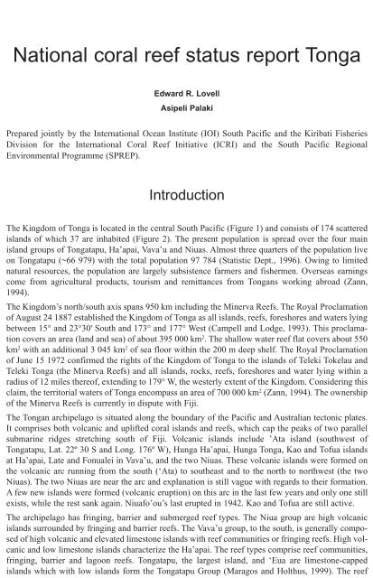
Figure 1<br />
Bathymetric Map of <strong>Tonga</strong>.
E. R. LOVELL, A. PALAKI — National coral reef status report <strong>Tonga</strong> 319<br />
Figure 2<br />
Kingdom of <strong>Tonga</strong>: Islands and Coral Reefs.
320 Coral reefs in the Pacific: Status and monitoring, Resources and management<br />
Status of coral reefs<br />
Few assessments of <strong>Tonga</strong>n coral reefs have been conducted. Description has been made by Dawson<br />
(1971) of Tofua, Kao, Late and Vava’u. Chesher (1984a,b; 1985) described areas around <strong>Tonga</strong>tapu,<br />
Nomuka, Ha’apai and Vava’u groups. Zann et al. (1984) studied Fanga’uta Lagoon and adjacent coral<br />
reefs. Nunn (1993) described the unique algal-ridge forming a fringing reef along the southern coasts<br />
of <strong>Tonga</strong>tapu. The Marine Parks Center of Japan (1997) conducted an inventory of the corals, molluscs<br />
and fish of <strong>Tonga</strong>’s marine reserves around <strong>Tonga</strong>tapu. Holthus (1996) described the coral reefs<br />
of Vava’u.<br />
Marine Total No Total Total No. of Recognizable Reef Systems Tot.Lagoon Tot. Reef<br />
Area Island Land Population And Perim (km)<br />
(km2) Systems Area (1987) Reef Fringing Barrier Atoll Reef Area<br />
Communities<br />
or submerged<br />
Reefs<br />
Or Lagoon (Km2)<br />
700,000 174 699 98,689 7 37 6 0 ? ?<br />
Adapted from Maragos and Holthus (1999)<br />
Table 1<br />
Geographic Statistics<br />
Island and Reef Types<br />
Details of the islands shows the types of landforms and reef types that exist (Table 2). Much information<br />
is lacking, representing gaps in our understanding of the coral reefs of <strong>Tonga</strong>. Some island<br />
types are basically volcanic some of which are active but most are composed of non-calcareous rock.<br />
The high limestone islands represent old coral reef accretion, which has been uplifted and aerially eroded.<br />
These are Pleistocene or Holocene in origin. Low coral islands are composed of deposits of coral<br />
rubble or sand.<br />
From the larger islands of <strong>Tonga</strong>tapu and ‘Eua in the south, a series of reefs extend northward to<br />
Ha’apai and Vava’u. The reef types are fringing, which are represented as narrow reefs on the more<br />
recent volcanic islands to wide margins around the low islands and may contain lagoons. Platform<br />
reefs exist as detached shelf reefs. Other types are wave-cut raised reefs, lagoon and barrier reefs.<br />
Lagoon reefs are the patch reefs within the lagoon or the reef that surrounds it. The barrier reefs are<br />
those detached from the island. Reef communities are those reefs composed of coral assemblages but<br />
not being incorporated into a consolidated reef substrate. They may be referred to as submerged reefs<br />
or exist on soft bottom sediments. The long Ha’apai reef is unique as it lies on the upthrust edge of<br />
the Indian-Australian plate. The Ha’apai Group contains the largest area of coral reefs in <strong>Tonga</strong>, and<br />
amongst the largest in the South Pacific (Zann, 1994).
E. R. LOVELL, A. PALAKI — National coral reef status report <strong>Tonga</strong> 321<br />
Name Island Type & Island Area Reef Type Reef Lagoon Number of Number<br />
Number Perimeter Area (km2) Passes and<br />
Channels<br />
Lagoon Reefs<br />
NIUA GROUP<br />
Fonualei 1 high volcanic 3.12 Fringing ? 0 0 0<br />
Niua Fo’ou 1 high volcanic 52.3 ? 26.8 0 ? 0<br />
Niuatoputapu 1 high volcanic 15.6 Barrier 18.8 ? ? ?<br />
Tafahi 1 high volcanic 3.4 ? 7.3 ? ? ?<br />
Toku 1 high volcanic 0.4 Fringing 2.6 ? ? ?<br />
Vava’u Group<br />
Euakafa ? 0.52 ? ? 0 ? 0<br />
Fangsito ? 0.067 Reef<br />
community<br />
& fringing ? 0 ? 0<br />
Fofoa ? 0.83 Fringing ? ? ? ?<br />
Fonua’one’one ? 0.049 Fringing ? 0 ? 0<br />
Hunga 1 high limestone 5.6 Fringing 18.6 ? ? ?<br />
Kapa 1 high limestone 6.4 ? 15.0 ? ? ?<br />
Koloa ? 1.8 ? ? ? ? ?<br />
Lape & Langitau 2 islands 0.04 ? ? ? ? ?<br />
Late 1 high volcanic 17.4 ? 28.8 ? ? ?<br />
Maninita ? 0.028 Fringing ? ? ? ?<br />
Nuapapu ? 3.2 Fringing 15.7 ? ? ?<br />
Ofu ? 1.25 Fringing ? ? ? ?<br />
Okoa ? 0.44 ? ? ? ? ?<br />
Olou’a ? 0.49 ? ? ? ? ?<br />
Ovaka ? 1.3 Fringing ? ? ? ?<br />
Pangimotu 1 high limestone 9.2 ? ? ? ? ?<br />
Taula ? 0.041 Fringing ? ? ? ?<br />
Taunga ? 0.36 Fringing ? ? ? ?<br />
‘Uta Vaba’u Many high 86 Fringing ? ? ? ?<br />
limestone<br />
‘Utungake 1 high limestone 0.93 ? ? ? ? ?<br />
Vaka’eitu 1 high limestone 6.90 Fringing 99.0 ? ? ?<br />
Vava’u 1 high limestone 103.6 ? ? ? ? ?<br />
55 Other Islands in the Vava’u Group Totaling 4,456km2<br />
Ha’apai Group<br />
Fetoa ? 0.16 ? ? ? ? ?<br />
Fetokopunga ? 0.008 ? ? ? ? ?<br />
Foa 1 high coral 13.4 ? 18.1 ? ? ?<br />
Fonoifua 1 low coral 0.16 ? ? ? ? ?<br />
Fonuaika 1 low coral 0.02 Fringing ? ? ? ?<br />
Fonuafo’ou Submarine<br />
volcanic &<br />
intermittent island 0 Reef community 0 0 0 ?<br />
Fonualei 1 high volcanic 4.3 ? ? ? ? ?<br />
Fotuha’a 1 high 1.13 Reef community 11.0 0 0 ?<br />
Ha’afeva 1 high limestone 2.02 Barrier 14.8 ? ? ?<br />
Ha’ano ? 6.58 ? ? ? ? ?<br />
Hakauata ? 0.02 ? ? ? ? ?<br />
Home 1 submarine volcano 0.0 Reef community ? 0 ? ?<br />
Hunga Ha’apai 1 high volcanic 0.4 ? ? 0 ? ?<br />
Kao 1 high volcanic 11.6 Reef community 14.2 ? ? ?<br />
Kelefesia 1 high volcanic 0.12 ? ? ? ? ?<br />
Kito 1 high 0.012 Fringing ? ? ? ?<br />
*Kotu 1 high 0.16 ? ? ? ? ?<br />
Lalona 1 low 0.28 ? ? ? ? ?<br />
Lekeleka 1 low 0.12 ? ? ? ? ?<br />
Lifuka 1 high limestone 11.0 ? 21.8 ? ? ?
322 Coral reefs in the Pacific: Status and monitoring, Resources and management<br />
Limu ? 0.04 ? ? ? ? ?<br />
Lofanga 1 high 1.46 Fringing and lagoon ? ? 2 ?<br />
Luahoko 1 low 0.001 Fringing ? ? ? ?<br />
Luanamo ? 0.024 Fringing ? ? ? ?<br />
Luangahu ? 0.61 Fringing ? ? ? ?<br />
Mango 1 high volcanic<br />
and limestone 0.64 Fringing and lagoon ? ? ? ?<br />
Manoiki ? 0.16 ? ? ? ? ?<br />
Matuku ? 0.34 ? ? ? ? ?<br />
Meama ? 0.002 ? ? ? ? ?<br />
Mo’unga’one 1 high limestone 1.15 ? ? ? ? ?<br />
Niniva ? 0.49 Reef community ? ? ? ?<br />
Nomuka 1 high limestone 5.34 ? ? ? ? ?<br />
Nomukaikai 1 high volcanic<br />
and limestone 0.66 Fringing ? ? ? ?<br />
Nuku 2 0.016 Fringing ? ? ? ?<br />
Nuku Falau ? 0.012 Fringing ? ? ? ?<br />
Nukulei ? 0.012 Fringing ? ? ? ?<br />
Nukupule ? 0.032 Fringing ? ? ? ?<br />
Nukutula ? 0.08 Fringing ? ? ? ?<br />
Ofolanga ? 0.89 Barrier ? ? ? ?<br />
O’ua ? 0.97 ? ? ? ? ?<br />
Putuputu’u ? 0.001 ? ? ? ? ?<br />
Tatafa ? 0.23 ? ? ? ? ?<br />
Teaupa ? 0.02 ? ? ? ? ?<br />
Tanoa ? 0.012 Fringing ? ? ? ?<br />
Telekitonga 1 low 0.45 ? ? ? ? ?<br />
Telekivava’u 1 low 0.02 ? ? ? ? ?<br />
Tofua 1 high volcanic 49.9 Reef community 26.7 ? ? ?<br />
Tolulu 1 low 0.012 ? ? ? ? ?<br />
Tonumea 1 high limestone 0.12 ? ? ? ? ?<br />
Tungua ? 1.52 ? ? ? ? ?<br />
Uanakuhihifo ? 0.1 Fringing ? ? ? ?<br />
Uanakuhahake ? 0.49 Fringing ? ? ? ?<br />
‘Uiha 1 high 5.37 ? ? ? ? ?<br />
Uoleva 1 limestone 3.0 ? ? ? ? ?<br />
10 Other island in the Ha’apai Group Totaling 0.594 km2<br />
<strong>Tonga</strong>tapu Group<br />
‘Ata 1 high volcanic 2.27 ? ? ? ? ?<br />
‘Eua 1 high volcanic 87.43 Fringing 45.2 ? ? ?<br />
Kalau 1 island 0.2 ? ? ? ? ?<br />
Minerva 1 low coral ? ? ? ? ? ?<br />
<strong>Tonga</strong>tapu 1 high limestone<br />
& 7 low coral islets 259.3 Fringing and lagoon 135.0 ? ? ?<br />
‘Euaike 1 high limestone 1.05 ? ? ? ? ?<br />
Mahaha’a 1 low coral 0.039 Fringing ? ? ? ?<br />
Malinoa 1 low coral 0.73 Fringing ? ? ? ?<br />
Manima 1 low coral 0.03 ? ? ? ? ?<br />
Monuafe 1 low coral 0.02 Lagoon ? ? ? ?<br />
Nuku ? 0.04 ? ? ? ? ?<br />
‘Oneata 1 low coral 0.078 ? ? ? ? ?<br />
Pangaimotu 1 low coral 0.223 Fringing and lagoon ? ? ? ?<br />
14 Other Islands in the <strong>Tonga</strong>tapu Group Totaling 1.427 km2<br />
Adapted from Maragos and Holthus (1999): after Dahl (1991); ENEP/IUCN (1988)<br />
Table 2<br />
Islands and Coral Reefs of <strong>Tonga</strong>.
E. R. LOVELL, A. PALAKI — National coral reef status report <strong>Tonga</strong> 323<br />
It is evident from the Table 2 that much needs to be documented with respect to the details of the coral<br />
reefs of <strong>Tonga</strong>. This lack of assembling knowledge prevents an accurate assessment of the country’s<br />
natural wealth. Its value to tourism or fisheries relies on an understanding of the nature of the reef<br />
resource. One of the goals of the management of this resource is to quantify the nature of the reefs<br />
(i.e. replace the question marks). This is fundamental to development of coral reef management plan.<br />
Biodiversity<br />
There were 192 species of scleractinian corals described from the reefs around <strong>Tonga</strong>tapu (11 reefs<br />
were sampled including the marine reserves). The coral coverage range from 2% Mounuafe reef to<br />
50% at Hakaumama’o reef reserve (MPCJ, 1997). Holthus (1996) found that there was a mix of healthy,<br />
degraded and recovering coral communities (36 reef sites sampled in Vava’u). The reefs are described<br />
with respect to corals (73), echinoderms (6), some shellfish, algae and seagrass, and an<br />
overview of the reef types. The presence of the crown-of-thorns starfish was recorded through noting<br />
feeding scars.<br />
Threatened and depleted species<br />
Black coral (Antipathes) and some molluscs were considered depleted in some areas of <strong>Tonga</strong><br />
(ESCAP, 1990). There are six species of giant clam known to <strong>Tonga</strong>. Hippopus hippopus, the horse<br />
foot Tridacna clam has become extinct in <strong>Tonga</strong> in recent times (McKoy, 1980). This is also the case<br />
in Fiji and human collection is implicated but the fate of the species remains a mystery. The giant clam<br />
Tridacna derasa is considered severely over fished and has given rise to a mariculture program to reestablish<br />
the populations (Chesher 1986, 1987, 1991, 1993; Chesher and U. Fa’anunu, 1991). The<br />
species Tridacna tevoroa, endemic to the Lau and <strong>Tonga</strong>n waters, has been overfished in the Ha’apai<br />
Group (Zann, 1994).<br />
The survival of the green and hawksbill turtles may be threatened (Braley 1973 a,b; 1974). They are<br />
protected by law during the nesting season, though this is largely ineffectual (ESCAP, 1990).<br />
Biodiversity<br />
Status of fishes<br />
General surveys have concentrated on the marine park areas. 229 species of fish were found in 39<br />
families in the reefs around <strong>Tonga</strong>tapu. Hakaumama’o Reef Reserve showed the greatest diversity<br />
with 127 species in 28 families. The most common families are the Labridae and Pomacentridae. Reef<br />
Fish of <strong>Tonga</strong> (Smithsonian Institute, 1993) provide information on the fishes of the Kingdom. 55 species<br />
of bivalves and 83 species of gastropods from 3 different habitats: seagrass bed, coral reef, sand<br />
were described (MPCJ, 1997). There are 13 species of holothurians, three, of which, are important<br />
commercial species.
324 Coral reefs in the Pacific: Status and monitoring, Resources and management<br />
a b<br />
c d<br />
e f<br />
g h<br />
The Coral Reef Environment: Kingdom of <strong>Tonga</strong><br />
a) The islands (left to right) of Pangimotu, Makaha’a, Manima and ‘Oneata north of <strong>Tonga</strong>tapu. The coral reefs radiate around<br />
Pangaimotu and Makaha’a with seagrass beds appearing as darker, blotchy areas inshore and, extensively, between the islands<br />
of Makaha’a, Manima and ‘Oneata.<br />
b) The coralline (Porolithon) algal ridge/fringing reef growth off the southwest coast of <strong>Tonga</strong>tapu.<br />
c) Narrow fringing reefs line the deep channel (~20m) between Vava’u and Pangai Motu with Neiafu middle right.<br />
d) Wave cut notch on Koloa, a raised limestone island in the Vava’u Group.<br />
e) A fringing reef Uonukuhahaki I. and Uonukuhihifo I. (left) and their fringing reefs in the southern portion of the Ha’apai Group.<br />
f) Seagrass meadows north of <strong>Tonga</strong>tapu with the green algae, Cladosiphon sp., fouling the beds.<br />
g) The seaward slope (5-6m depth) adjacent to Ha’atafu Beach Reserve, <strong>Tonga</strong>tapu. Evidence of the coral bleaching event can<br />
be seen.<br />
h) Close up of the coral assemblage (from g) shows coral bleaching resulting from the recent South Pacific warm water event.<br />
Bleaching in this Acropora dominated assemblage was largely confined to the corymbose colonies.
E. R. LOVELL, A. PALAKI — National coral reef status report <strong>Tonga</strong> 325<br />
Fisheries<br />
The average reef fish production is indicated in Table 3. The catch for the various localities are given<br />
in Table 4.<br />
Subsistence fisheries Nominal Value Commercial Value (US$) Total fisheries Nominal Value<br />
production (mt) (US$)<br />
production (mt)<br />
fisheries production (mt) (US$)<br />
933 1,901,208 1,429 2,806,641 2,362 4,707,849<br />
After Adams and Dalzell (1999) in Eldridge et al. (1999)<br />
Table 3<br />
Subsistence and Commercial Fisheries: Annual mean production - 1989 to 1992.<br />
Commercial Subsistence Total<br />
Nuku’alofa 1,000 375 1,375<br />
Vava’u 250 280 530<br />
Ha’apai 100 180 280<br />
Other 79 98 177<br />
TOTAL 1,429 933 2,362<br />
FAO Digital Atlas, 1998<br />
Table 4<br />
Catch landings (tonnes).<br />
The finfish resource from the shallow-water reefs has been a major source of protein both in the subsistence<br />
and the artisanal fisheries in <strong>Tonga</strong>. 1993 estimates of fish landings at two landing sites, Vuna<br />
and Faua in Nuku’alofa, indicate that fish species classified as shallow-water reef fishes make up<br />
almost 70 per cent (200 mt) of the total artisanal finfish landings there. The main fish family recorded<br />
was parrotfishes. In 1987, the shallow-water reef fish landing in the <strong>Tonga</strong>tapu artisanal fishery<br />
was estimated to be 333 mt of which emperors were the main family. 140 tonnes of mullet were landed.<br />
Apart from the reef and lagoon fish, other coral reef fisheries are beche-de-mer, the molluscs (trochus,<br />
triton, shell collecting, Tridacna spp.), aquarium coral and fish, and precious coral.<br />
Though many of the mollusc resources are not harvested on a sustainable level, these resources have<br />
been an important seafood component in both the subsistence and artisanal levels of utilization. Giant<br />
clams have been subjected to heavy exploitation leading to very low populations in certain areas. The<br />
estimated shellfish (including giant clams) landing at Vuna and Faua in 1993 is 118 mt with Anadara<br />
making up 34 per cent and giant clams 33 per cent.<br />
The development of the aquarium fish trade in <strong>Tonga</strong> has led to the utilization, not only of the small<br />
colourful reef fishes, but also juvenile giant clams, other shellfish species, corals and sea anemones<br />
(Matoto, 1997; Oliver and Smith 1994; Matoto et al. 1996). Export data submitted by the main aquarium<br />
fish exporter indicate that, in terms of the number of pieces exported during 1993, corals made<br />
up about 60 per cent of the total exports during the year. Between 1995 and 1996, aquarium exports<br />
by composition were fish 27 %, live coral and rock 29 %, soft coral 27 %, invertebrates 15 %, giant<br />
clams 2 %. Of the fish, 54 % were damselfish, 17 % angelfish, 11 % wrasses, 8 % clownfish, 6 %<br />
hawkfish, 2 %, butterfly fish and 2 % tangs (Matoto, 1997).<br />
Harvesting of sea-cucumber for consumption on the subsistence level has never been high. This<br />
resource forms only a small portion of the local fishery. However, the commercial production of
326 Coral reefs in the Pacific: Status and monitoring, Resources and management<br />
bêche-de-mer for export has been a major development within the last few years. Some limited processing<br />
was reported in the 1980’s but the industry boomed starting in 1990 when markets were established<br />
for a species currently known in <strong>Tonga</strong> as the sandfish, Holothuria scabra. This seacucumber<br />
species is abundant in shallow lagoons and fetches higher prices than the teatfish.<br />
Two giant clam species, Tridacna gigas and Hippopus hippopus, were re-introduced into <strong>Tonga</strong> in<br />
1990 and 1991. Both species are believed to have become locally extinct. The giant clam project started<br />
in <strong>Tonga</strong> with the creation of clam circles in 1986. Clam circles were created by the Ministry of<br />
Lands, Survey and Natural Resources in an attempt to revitalize the stocks of these animals. Several<br />
community giant clam sanctuaries were initiated. The first community-based clam circle was set up<br />
in Vava’u (Falevai community circle) and the Fisheries Division has continued with the program. Due<br />
to faster growth rates, the current giant clam project is concentrating on the production of T. derasa<br />
and T. tevoroa and the establishment of community-owned ocean nurseries. Recent inspection has<br />
revealed the clam circles at Falevai to be depleted of clams due to stealing and lack of attention. Signs<br />
have been erected to warn yachts from anchoring there (World Bank Report, 1999c).<br />
Four hundred live Trochus niloticus were introduced from Fiji in 1992 and released on a reef west of<br />
Tapana Island, Vava’u (donor FAO). In 1994, 1100 were released in <strong>Tonga</strong>tapu (donor JICA). In 1995,<br />
500 were released in Ha’apai (FAO/JICA donors). In 1994, there was the first spawning induction and<br />
2000 were released in Vava’u, Ha’apai, <strong>Tonga</strong>tapu, and Niue. The second spawning in 1997 produced<br />
10 000. About 2000 were released in Ha’apai and Vava’u. Evidence of new recruitment were<br />
reported from Vava’u, Ha’apai and <strong>Tonga</strong>tapu.<br />
Fifty mature green snails, Turbo marmoratus, were introduced from the Republic of Vanuatu in 1995.<br />
Twenty of these green snails were released in the wild at Hufangalupe but 23 were kept in baskets at<br />
the Ministry of Fisheries’ giant clam ocean nursery in Sopu (FAA 1994). In 1996, 320 were introduced<br />
from Okinawa, Japan and 30 introduced from Vanuatu. 2719 were released in <strong>Tonga</strong>tapu, 2500 in<br />
Vava’u, 500 in Ha’apai. In a seed production and release program in 1997, 40 were released. The program<br />
continues with 1900 (1997), 3800 (1998) and 10 000 (1999) released in cages and raceways.<br />
JICA researched an environmental impact assessment, though there has been no attempt to conduct<br />
an EIA for other species.<br />
Four Panulirus species of spiny lobsters are found in <strong>Tonga</strong>. The main species harvested are the doublespine<br />
lobster (P. penicillatus) and the slipper lobster (Parribacus caledonicas). Information on the stock<br />
size, ecology and biology of this animal is incomplete. The stock is declining from overfishing.<br />
There are seven species of mullet in <strong>Tonga</strong>. Four, of which, are currently fished and declining due to<br />
being overfished. In 1992, MOF/JICA set up a project to culture mullet in <strong>Tonga</strong>. Fish fry of the species<br />
L. macrolepis, V. seheli, M. cephalus from the wild and were reared for re-stocking in pens<br />
constructed near Tofoa in Fanga’uta lagoon but was later destroyed by hurricane.<br />
Fisheries policies<br />
<strong>Tonga</strong>’s overall fishery policy is to increase fish production for export and as a source of high-quality<br />
protein for <strong>Tonga</strong>ns. Along with long lining and mariculture, future management objectives are to<br />
improve the subsistence and small-scale commercial fisheries. This involves development of fishery<br />
co-management arrangements to promote greater involvement by fishers and communities in inshore<br />
resource management.<br />
<strong>Tonga</strong> has a limited natural resource base except for the potential of the EEZ. Fish is one of <strong>Tonga</strong>’s<br />
highest export commodities, and marine fish offer considerable potential for sustainable resource
E. R. LOVELL, A. PALAKI — National coral reef status report <strong>Tonga</strong> 327<br />
development. Although increasing amounts of imported fish and meat are consumed, especially in the<br />
urban centers, fish remains important particularly in the outer islands. Lack of land means an increasing<br />
reliance on the subsistence marine products. Subsistence activity from shallow-water reef and<br />
lagoons surrounding the islands provides a vital source of protein. The Government of <strong>Tonga</strong> is<br />
concerned with developing methods of increasing commercial production of fisheries without overexploiting.<br />
Fisheries are important but <strong>Tonga</strong> is a net importer of fish products. Much of the fishing<br />
is semi-commercial. 70% of the total annual catch are reef-lagoon fish. Octopus is popular and often<br />
abundant. Clam fishing used for local consumption, decoration and a small amount of export. Black<br />
coral is collected and fashioned into jewelry. Turtles are eaten for eggs and meat with the carapace<br />
used for decoration and jewelry.<br />
Natural and anthropogenic threats to biodiversity<br />
Anthropogenic Threats<br />
75 % of the islands are uninhabited. The population is principally located on <strong>Tonga</strong>tapu and around<br />
the provincial centers on ‘Eua, Lifuka in the Ha’apai and Neiafu in Vava’u. The population is growing<br />
at 0.5 % annually and there is an urban growth of 2.5 %. As a result, fishing has reduced stocks around<br />
<strong>Tonga</strong>tapu and other populated areas.<br />
Anthropogenic threats may involve construction, quarrying, pollution, overfishing, recreational activities<br />
or tourism. Fishing activities such as gleaning, dynamite or poisoning can have persistent<br />
impacts. Siltation from construction and quarrying sites have degraded the reefs adjacent to<br />
Nuku’alofa and Neiafu, Vava’u, though this is a localised problem in all of the groups. Causeway<br />
construction in the Ha’apai and Vava’u has caused degradation. Mangrove cutting has been banned<br />
but still occurs. Sand mining from beaches and dunes is a major problem.<br />
The World Bank Report (1999b) identified threats at the community level as waste or rubbish pollution,<br />
pressure on resources from outside users, the cutting of mangroves and damaging of corals.<br />
Pollution and damage may result from discarded fish-fence wire and batteries. Removal of shell, gravel<br />
and muddy sands has destroyed mussel habitat. Causeway construction has blocked the water<br />
interchange and caused a build up of mud, which affected Gafrarium stocks. Anchoring in the clam<br />
circles was perceived as a problem. Net fishing and sophisticated gear use contributed to overfishing.<br />
Eutrophication<br />
<strong>Tonga</strong> does not have a sewerage system. Eutrophication by sewage (septic systems) occurs particularly<br />
at Nuku’alofa. An estimated 250 t of fertilizer is used on <strong>Tonga</strong>tapu and Vava’u each year as of<br />
1990 (ESCAP, 1990; Zann, 1994).<br />
In Fanga’uta Lagoon, <strong>Tonga</strong>tapu, an increase in seagrasses and mangroves and a decline in stony<br />
corals were to some extent attributed to eutrophication from urban nutrient run-off (Zann et al., 1984;<br />
Zann and Muldoon, 1993). Landfill and the cutting of mangroves were considered problems.<br />
The monitoring program currently running as part of TEMPP project (<strong>Tonga</strong> Environmental<br />
Management and Planning Project) is assessing the physical and environmental parameters such as<br />
nutrients, trace metals, pesticides, and general biology of the lagoon (Morrison J. 1999). The monito-
328 Coral reefs in the Pacific: Status and monitoring, Resources and management<br />
ring is budgeted to the Environmental Planning and Conservation Section, Ministry of Lands, Survey<br />
and Natural Resources to continue to the project.<br />
Initial assessment of the physical and environment parameters, seem normal (e.g. pH, salinity, temperature,<br />
dissolved oxygen, and turbidity. The results were similar to other non-polluted lagoons being<br />
relatively free of contamination.<br />
Summary research results found that nitrate and phosphate are limiting with respect to seasonal patterns.<br />
Four general surveys per year and a monthly program for nutrients are underway. Nitrates and<br />
phosphates are below the EPA guidelines. Ammonia was slightly elevated in some areas but below<br />
the EPA guidelines. The possible sources are septic system contamination.<br />
Tests for E. coli in water, sediment and shellfish found levels below the EPA and WHO guidelines.<br />
The lagoon is considered safe for recreation and gleaning. Pesticides residues were sampled in sediment<br />
and soil. Two pesticides were present but in very low (ppb) concentrations (Chen, 1999).<br />
Trace metals, though present in shellfish and sediments were unlikely to cause any major health problems.<br />
For many elements, the concentrations were below the detection levels, confirming no major<br />
problems with metal contamination (Brown and Morrison, 1999).<br />
Tourism<br />
Tourism is increasing with fishing pressure on delicacy items like lobster. SCUBA diving is available<br />
in Nuku’alofa and Vava’u increasing tourist appeal and making more of the coral reef available.<br />
<strong>Tonga</strong>n tourism increased from 17 000 annually in 1982 to 25 500 in 1992. In some areas, the continuous<br />
fossicking by tourists is responsible for the breakage of corals though that caused through gleaning<br />
by <strong>Tonga</strong>ns is widespread and far exceeds this. Habitat loss has impacted other marine life.<br />
Anchorage of boats whether due to local fishing or tourism (diving boats etc) can be a problem.<br />
Overfishing<br />
For inshore fisheries, increased fishing pressure driven by improved access to markets, rising prices,<br />
and population growth is resulting in remarkable declines of important inshore marine resources<br />
(World Bank, 1999 a,b,c). There are numerous indications that both the condition of the resource is<br />
deteriorating and conflicts between user groups are increasing. Unlike the situation in other Pacific<br />
Island countries, coastal communities in <strong>Tonga</strong> have no preferential access to adjacent resources. This<br />
open-access situation may have worked reasonably well in the era of subsistence fisheries, but it has<br />
fairly recently collided with commercial realities and the carrying capacity of inshore resources. There<br />
is heightened concern by residents of outer islands that <strong>Tonga</strong>ns from anywhere, especially commercial<br />
operators from <strong>Tonga</strong>tapu, could harvest the food resources adjacent to their villages in outer<br />
islands thereby affecting the food security situation. The Ministry’s management interventions in<br />
inshore fisheries appear to fall into two categories: (1) implementation of the provisions of the<br />
Fisheries (Conservation and Management) Regulations 1993, and (2) bold action in support of fisheries<br />
which have collapsed (e.g. banning the export of giant clams in 1994 & beche-de-mer in 1997).<br />
In many areas, overfishing of inshore resources is now severe and the deficiencies of a centrally<br />
implemented, regulation-based management system are becoming apparent. Fishery regulations are<br />
generally poorly understood or observed, and enforcement through <strong>Tonga</strong>’s many scattered islands<br />
and reefs are difficult or impossible. The government is thus now investigating the possibility of comanagement<br />
arrangements, under which responsibilities would be shared between government and<br />
fishing communities. Many local fishers and communities are in favour of such arrangements, and a<br />
pilot project is likely to be soon underway in Ha’apai (Petelo et al., 1995; Gillett, 1997).
E. R. LOVELL, A. PALAKI — National coral reef status report <strong>Tonga</strong> 329<br />
A ban on beche-de-mer exporting has been imposed in response to serious overfishing during the past<br />
five years. The ban is for ten years, although there is provision for a review after five years.<br />
Overfishing is a problem with other species, particularly clams. Black coral has also been overexploited.<br />
The method of dragging an anchor line along the seabed to collect black coral is damaging<br />
to general benthos.<br />
Destructive fishing techniques can be a major contributor to reef degradation. These involve smashing<br />
reefs to chase fish into nets, and the turning and breaking of rocks and coral to take invertebrates.<br />
Trampling of coral during food gathering on reef flats is a problem. Poisons such as bleach and pesticides<br />
are used.<br />
Impacts on Vava’u Reefs<br />
Holthus (1996) found human destruction and degradation of the coral reefs of Vava’u resulted directly<br />
form the breakage of coral during fishing activities, and indirectly from the input of increased silt and<br />
possibly chemicals (e.g. pesticides) and nutrients. Indicators of disturbance, Acanthaster, Diadema<br />
spp. and dead standing coral, were concentrated near land and in the eastern reef areas where coral<br />
diversity and live coral cover were found to be lower. Chesher (1985) found that 65% of the 100 reefs<br />
surveyed showed evidence of coral destruction from both natural and anthropogenic sources. Coral<br />
breakage through destructive fishing techniques during gleaning activities has heavily damaged some<br />
areas. The use of poisons may be widely destructive to fish and invertebrates and have long term<br />
impact. He detailed pollution sources (Chesher, 1984a).<br />
Areas of Impact<br />
Areas of disturbance are Fanga’uta lagoon in <strong>Tonga</strong>tapu (eutrophic, major coral mortality and collapse<br />
of fisheries); Nuku’alofa and adjacent northern <strong>Tonga</strong>tapu (physical disturbance, loss of habitat,<br />
eutrophic, overfishing, coral mortality). The inner reef areas along Ha’atafu Beach have<br />
experienced a proliferation of algal growth (Turbinaria and Sargassum spp.) in recent years due to<br />
eutrophication of lagoon waters. Inner Neiafu Harbour in Vava’u has been affected by sedimentation,<br />
crown of thorns, overfishing, and coral mortality (Zann, 1994).<br />
Natural Impacts<br />
Natural threats are volcanic activity, tropical cyclones, Acanthaster outbreaks, coral bleaching, coincidence<br />
of low spring tide, high temperature and rainfall. Coral mortality and the colonization by blue<br />
green algae may result from a variety of natural circumstances but may be attributed to stresses caused<br />
by storm damage, pollution, causeway construction and destructive fishing techniques (Chesher<br />
1985). As most islands are low and lack rivers, soil loss and flooding is minimal. Flooding can be a<br />
major problem with cyclonic rain on <strong>Tonga</strong>tapu.<br />
Destructive cyclones occurred in the years of 1982, 1995, 1997, 1999 and 2000. In 1998, an El Niño<br />
year, high temperature during a daytime (noon) spring low tide affected benthic marine organisms. La<br />
Nina periods following El Niño are characterized by a period of heavy rain, decreased salinity and<br />
may affect marine organisms, especially during spring low tide.<br />
The crown- of- thorns starfish, Acanthaster planci, have been reported throughout the archipelago.<br />
Outbreaks of the starfish have not been noted but chronic elevation of numbers has been recorded in<br />
Vava’u harbour in the early 1970 and 1980’s. Moderate numbers were recorded at Ha’atafu and<br />
Pangaimotu Island off <strong>Tonga</strong>tapu in 1992 (Zann and Muldoon, 1992).
330 Coral reefs in the Pacific: Status and monitoring, Resources and management<br />
Current and potential climate change impacts<br />
Global warming<br />
In recent years, concern has grown that the Earth's atmosphere is changing due to human causes burning<br />
of fossil fuels and deforestation among them. It is feared that this effect may cause global warming<br />
with an increase in sea temperatures. Studies suggest that global change of this magnitude could<br />
cause significant problems, including melting of the icecaps resulting in a sea level rise.<br />
Global warming and sea-level rise are of concern in the low islands in terms of an alteration of coastal<br />
processes, submergence, pollution of groundwater and coral bleaching. Climate change may mean<br />
increased cyclonic activity, alteration in the rainfall pattern and periodic elevation in sea temperature.<br />
Coral bleaching<br />
Coral reef bleaching is a response to stress. The bleaching refers to the colouration of the organism<br />
resulting from the breakdown in the mutualistic dependency between the coral and the zooxanthellae.<br />
The corals lose some or all of the symbiotic microalgae (zooxanthellae), living in its endodermal cells.<br />
The effect occurs in diverse invertebrate taxa. It frequently results in a white colouration due to the<br />
whiteness of the coral skeleton or the soft coral tissue. A bleached organism may be particularly<br />
brightly coloured due to the appearance of its natural animal coloration in the absence of the darker,<br />
green/brown, zooxanthellae. Though bleaching may be caused by a variety of stresses (freshwater,<br />
ultra-violet light). The recent widespread bleaching observed globally is the result of prolonged periods<br />
(few weeks or more) of elevated temperature 1-20C above average sea temperatures.<br />
Historically, published records of coral reef bleaching incidents from 1870 to present suggest that the<br />
frequency, scale and severity of recent bleaching events are unprecedented. There have been 60 major<br />
events from 1979 to 1990 globally (Glynn, 1993) with four of the most severe occurring in French<br />
Polynesia in 1994; Maldives and Indian Ocean in 1997/98; the Great Barrier Reef in 1998; Palau in<br />
1998 and Fiji, <strong>Tonga</strong> and Cook Islands in 2000. There has been a co-occurrence in many coral reef<br />
regions and often over the bathymetric depth range of corals with > 95% mortality in some areas.<br />
Causes of small scale bleaching events can often be attributed to particular stresses but the widespread<br />
effect is certainly from elevated temperatures caused by maximum seasonal solar heating and calm<br />
clear weather allowing the sea surface to heat up. Global temperature satellite surveillance by the<br />
National Oceanic and Atmospheric Agency (NOAA) has revealed areas of elevated sea surface temperatures,<br />
which exceed the average sea temperatures for periods of time and are characterized by a<br />
bleaching event. A constant referred to as Degree Heat Weeks (DHW) is now being tested to determine<br />
the extent of bleaching as the result of both degree of elevation over the average, and length of<br />
warming period. In the Maldive Islands situation (Wilkinson et al., 1999) and currently in Fiji, the<br />
satellite assessment of hotspots was very accurate in determining the areas and degree of bleaching<br />
that occurred.<br />
Given the projected elevation of temperatures (1-20C) over the next 30 years (Manabe et al., 1991),<br />
there is concern that the upper thermal tolerance limits of many reef-building corals could be exceeded.<br />
Many corals may be unable to adapt physiologically or genetically to such marked and rapid temperature<br />
increases. Coral bleaching around the world would increase in frequency and severity until<br />
it occurred annually by 2030, unless global warming is reversed. Depending on its severity or frequency<br />
of occurrence, a single bleaching event will take reefs from 30 to 100 years to recover. If there
E. R. LOVELL, A. PALAKI — National coral reef status report <strong>Tonga</strong> 331<br />
is unrestrained warming, then the coral fauna will be progressively reduced and require a much longer<br />
recovery time. Genetic accommodation, replacement by heat resistant species and/or global<br />
cooling would ameliorate the effects of bleaching (Hoegh-Guldberg, 1999).<br />
The South Pacific bleaching event currently underway was the result of the warming of a band of<br />
oceanic water extending from Fiji to Easter Island and included the Cook Islands and <strong>Tonga</strong>.<br />
Bleaching has occurred in all of those places.<br />
In Fiji, bleaching is 90% in some areas. Only a few species remain unaffected. The effect is not uniform<br />
with less bleaching in the far northern part of the group. Other areas of the country for some unknown<br />
reason appear less affected. The bleaching is mainly confined to shallower than 30m and is not<br />
widespread at 40m.<br />
<strong>Tonga</strong>n Bleaching Event<br />
<strong>Tonga</strong> has reported coral bleaching (February, 2000) around <strong>Tonga</strong>tapu and the Ha’apai Group.<br />
Observations from the Ha’atafu Reserve on <strong>Tonga</strong>tapu (May 5-10) revealed the phenomena to be<br />
widely evident on the reef slope and in the lagoon. The event was similar to Fiji with the corals exhibiting<br />
varying degrees of bleaching. The nearshore lagoon is dominated by Montipora hispida with<br />
M. incrassata subdominant. Though representing areas of substantial coral cover, these species showed<br />
only minor bleaching. By contrast, Goniastrea retiformis, Platygyra sinensis and P. daedalea<br />
were invariably 80-100 % bleached.<br />
On the outer reef slope, the corymbose Acroporas were most notably affected with the tabulate colonies<br />
showing only minor bleaching and, in many cases, unaffected. Coral death was minimal with a<br />
visual estimate of 2-5 %. Those that had died and were covered in part or wholly by algal growth were<br />
the hydrozoan corals Millepora exaesa and M. dichotoma. Among the Acroporas, A. humilis, A. monticulosa<br />
and A. robusta were characterized by varying degrees of death. The first two showed a range<br />
of minor bleaching to total colony death. Some colonies of A. robusta were apparently entirely unaffected<br />
though other colonies were part or totally dead. Many colonies of this species were totally bleached<br />
though still living.<br />
Future Bleaching Events<br />
In 1997-98 the hottest average sea temperatures on record occurred in the Indian Ocean and this effect<br />
migrated throughout the Indian Ocean to varying degrees. The southeast Asian and western Pacific<br />
area was affected with particularly devastating effects on the coral reefs of Palau. In some places, the<br />
coral mortality was >95 %. Coral reefs became algal reefs.<br />
In the worst case scenario, events as severe as 1998 are now projected to become commonplace by<br />
2020. Globally, coral reefs are expected to face bleaching every year by 2030. During the past 100<br />
years the gradually increasing sea temperatures have been pushing the reefs closer to their tolerance<br />
levels, so now even the slightest increase in temperature can cause coral bleaching, This was witnessed<br />
in the Solomon Islands this year.<br />
The question remains as to how well the corals will adapt to the hotter conditions. Corals are not showing<br />
any sign they can adapt fast enough to keep pace with changes in ocean temperature. Most of<br />
the evidence indicates bleaching events are signs that the genetic ability of corals to acclimatize is currently<br />
being exceeded (Hoegh-Guldberg, 1999). Natural selection may prevail with the alteration in<br />
the species composition of the affected reefs.
332 Coral reefs in the Pacific: Status and monitoring, Resources and management<br />
Rising Sea-level<br />
Sea levels have fluctuated widely in the geologic past. Since the last ice age, sea level has been relatively<br />
stable. However, during the past 20 years, concern has been expressed in the scientific community<br />
that the atmosphere may be warming, and causing sea levels to rise catastrophically, with the<br />
melting of polar ice.<br />
If sea level change is a reality, it will have dramatic effects on coastal communities throughout the<br />
world. Although, coral reefs may be able to continue their upward growth with little real change in<br />
reef communities. However, there are limits to the rate of effective upward growth. Coral reefs represent<br />
a variety of locations and their growth rates also vary. Reefs which occur at depth grow more<br />
slowly and may be approaching the Darwin Point (Grigg, 1982) where they may ‘drown’ due to tectonic<br />
submergence. Some coral reefs that cannot continue their upward growth may have growth<br />
retarded due to factors such as chronic turbidity.<br />
El Niño conditions are accompanied by lower than normal sea level in the Western Pacific, which may<br />
lead to widespread death of corals due to exposure to air. Corals and coralline algae, and certain other<br />
reef organisms are distributed in well-defined zones. Organisms are distributed as they are in relation<br />
to tidal levels in the intertidal zone partly in response the rates of exposure. If for any reason such<br />
organisms are subject to different levels of exposure, they may die. Some are found only in wave<br />
washed areas or very shallow water, and very far from the intertidal zones.<br />
Increase in cyclonic storm intensity, rainfall extremes,<br />
frequency of El Niño events<br />
Anecdotal observations include:<br />
- a greater frequency of cyclones in the last few years;<br />
- increased rainfall;<br />
- higher average water temperature;<br />
- sea level trend positive (19mm/yr.) during the last few years;<br />
- seasonal variation shift by few weeks;<br />
- coral bleaching event in <strong>Tonga</strong>;<br />
- potential changes of the marine ecosystem and habitat due to changes in salinity etc.<br />
Potential climate change impacts:<br />
- erosion of coastal environment;<br />
- low lying areas in <strong>Tonga</strong> will be affected by the ingress of sea water;<br />
- changes in marine habitats.<br />
Marine protected ateas<br />
The concept of parks and reserves is not new to <strong>Tonga</strong>. In 1946, ‘Ata, the then Minister of Lands,<br />
gazetted a park reserve at Haveluloto along the shore of Fanga’uta Lagoon. This set the legal prece-
E. R. LOVELL, A. PALAKI — National coral reef status report <strong>Tonga</strong> 333<br />
dent of parks and reserves coming under the Ministry of Lands and demonstrate the foresight on the<br />
part of the <strong>Tonga</strong>n government. Then in 1972, King Taufa’ahau Tupou 1V declared 2 reserves at<br />
Muihopohoponga and at Ha’amonga Trilithon. Muihopohoponga is a 2 km stretch of beach on the<br />
extreme eastern end of <strong>Tonga</strong>tapu. The Ha’amonga Trilithon, the Stone Henge of the South Pacific,<br />
is a 23 hectare reserve. Under the Parks and Reserves Act of 1976, <strong>Tonga</strong> has gazetted two national<br />
parks, which comprise the entire islands of Mounuafe and Malinoa and five marine reserves. In 1979,<br />
two reserves were established around the island of Malinoa and Mounuafe and three reefs at<br />
Pangaimotu, Hakaumama’o and Ha’atafu. The Ministry of Lands, Survey and Natural Resources<br />
administers parks and reserves.<br />
The Minister for Lands is the chairman of the Parks and Reserve Authority with the members including<br />
the Secretary for Lands, Survey and Natural Resources, Secretary for Fisheries, Director of<br />
Agriculture and Forestry, Director of Tourism, Head of Environmental Planning and Conservation<br />
Section of the Ministry of Lands, Survey and Natural Resources.<br />
The whole Ha’apai group was declared as the Ha’apai Conservation Area by Cabinet following the<br />
recommendations by <strong>SPREP</strong>, Ministry of Lands, Survey and Natural Resources and the Ha'apai<br />
Committee. Proposed reserves for Vava’u are the Coral Garden at Nuapapu, Maninita and Mounu<br />
Island. Biological surveys or inventories of the reserves were carried out by Marine Parks Center of<br />
Japan (MPCJ) and the Ministry of Lands, Survey and Natural Resources in 1997.<br />
The Ministry of Lands, Survey and Natural Resources coordinates policymaking, natural resources<br />
and enforcement, as well as parks and reserves. Under the Parks and Reserves Act (1972), there were<br />
five marine reserves on <strong>Tonga</strong>tapu (see below). Some areas have been protected through Royal<br />
Proclamation. Fanga’uta and Fangakakau Lagoons are protected under the Birds and Fish<br />
Preservation Act of 1915 against commercial fishing, traditional fish traps, effluent discharge, dredging,<br />
the construction of any building works, harbours, wharves, piers or jetties, or the cutting of mangrove<br />
trees.<br />
The Parks and Reserves Act 1988 protects, manages and develops natural areas. The following five<br />
parks and reserves have been established under this Act (WCMC 1991):<br />
- Fanga’uta and Fangakakau Lagoons Marine Reserve - <strong>Tonga</strong>tapu<br />
- Hakaumama'o Reef Reserve<br />
- Pangaimotu Reef Reserve<br />
- Monuafe Island Park and Reef Reserve<br />
- Ha'atafu Beach Reserve<br />
- Malinoa Island Park and Reef Reserve.<br />
- ‘Eua Island National Park*<br />
(* not marine)<br />
Areas of black coral have been set aside by Government and a program of fragmenting and planting<br />
are management measures. Protected clams, arranged in circles, were also established to promote reestablishment<br />
of clam stocks. Turtles are theoretically protected through the Bird and Fish<br />
Preservation Act.<br />
Enforcement of park boundaries and regulations is poor. From the Fisheries Sector Study (Gillett<br />
1997), Adams and Ledua (1997) reviewed the regional experience with reserves and stated some of<br />
the problems:<br />
- Marine protected areas do not have a good record in the Pacific. It is usually difficult to get community<br />
agreement to set them up, and in areas where they do exist they are rarely respected or effec-
334 Coral reefs in the Pacific: Status and monitoring, Resources and management<br />
tively enforced. The lack of respect for the legislation sometimes results from its new and novel<br />
nature. Community-based management or involvement in decision making is a new concept to <strong>Tonga</strong><br />
as well as the other Pacific countries. Generally legislation in <strong>Tonga</strong> uses a top down approach.<br />
Progress is being made with the community and NGO involvement is now in place.<br />
- A particular community could be required to give up effective ownership of an area (even if legal<br />
ownership is vested in the State) for the long-term benefit of other communities.<br />
- The efficacy of reserves for rehabilitating or sustaining surrounding fisheries has not yet been unequivocally<br />
proven whilst their capacity to divert resources from other, perhaps more effective management<br />
and conservation methods, is well known. Despite this there is widely held belief and<br />
evidence that reserves are effective for rehabilitating and sustaining marine resources. Reserves are<br />
established for different purposes (IUCN categories) and each reserve serves its duty well enough<br />
even though there may be abuse through fishing.<br />
- With marine reserves in place, fisheries managers may be lulled into tranquillity and feel that<br />
nothing further need be done. Generally, however, diverse activities have been carried out in the<br />
reserves. A management plan is in place with a program of development. Funding and manpower can<br />
be a problem for some aspects of development and monitoring.<br />
In view of the above concerns, Gillett (1997) recommended only carefully considered and judicious<br />
use should be made of marine protected areas for inshore fisheries management in <strong>Tonga</strong>. Attention<br />
should be given to:<br />
- Establishing reserves only where there is full consultation and agreement from adjacent communities;<br />
- Realistically appraising the amount of surveillance/enforcement required for each reserve;<br />
- Assessing the total amount of Ministry surveillance/enforcement resources available for all inshore<br />
resource management and assuring that those resources channeled to reserves are in proportion to the<br />
benefits from reserves (i.e. not a dominant portion of all surveillance/enforcement resources)<br />
Clam Circles and other protection<br />
The first clam circle was at Mounu Reef and was established by the Ministry of Lands, Survey and<br />
Natural Resources with Dr. Richard Chesher and in the Pangaimotu Island Reserve. The first community-based<br />
sanctuary was established at Falevai by the Ministry of Lands and the Falevai community.<br />
Through awareness of the project’s objectives, respect was gained for the clam sanctuary<br />
concept. The success was the result of developing local understanding, providing legal protection and<br />
local involvement. A video was made and proved effective. In 1990, the King gave a prize for the best<br />
Giant Clam Sanctuary, which exists today. Sadly poaching occurred by a Fisheries officer in Vava’u.<br />
The Ministry of Fishery later established many clam circles in Vava’u.<br />
Policing of reserves, generally, is not difficult but funding is the main problem. There are two boats<br />
for patrol and scientific survey. Equipment was provided by JICA. Policing in <strong>Tonga</strong>tapu of several<br />
marine reserves has been a problem. Unlike the clam projects, the locals were not involved in the creation<br />
of and the gaining of respect for the reserves. Protection has proved to be extremely difficult.<br />
Game fishermen tag and release billfish and international billfish tournaments encourages tag and<br />
release. Sailing charter companies encourage protection of the marine environment by providing<br />
details of suitable anchorages. 1997 Guidelines were created and piloted by collaborative efforts between<br />
government officials and operators in an attempt to further protect the maritime environment<br />
(Ruffle-Klugkist, 1998).
E. R. LOVELL, A. PALAKI — National coral reef status report <strong>Tonga</strong> 335<br />
Flint (1999) notes seabird breeding sites of world importance. They are the islands of Fonualei, Hunga<br />
<strong>Tonga</strong>, Hunga Ha’apai, ‘Ata, Late, and Tofua. There are 16 breeding species and only one sea bird<br />
reserve. The vulnerable species that nest here are Herald’s Petrel, Audubon’s Shearwater, and possibly<br />
Phoenix Petrel. The threats are mammalian predators and human use. Actions required are the survey<br />
of the nesting populations, protection, management, and predator control. There is moderate<br />
intern legislation for the protection of seabirds.<br />
A detailed environmental management plan has been prepared but not implemented (ESCAP, 1990).<br />
<strong>Tonga</strong> is signatory to the Convention on Biological Diversity and the U.N. Convention on the Law of<br />
the Sea. It is not signatory to the Convention on International Trade in Endangered species.<br />
Conservation needs to be preached from the pulpit. There must be a responsibility for the clergy to<br />
preach conservation. It could be used in <strong>Tonga</strong> with effective results.<br />
Current monitoring and management capacity<br />
Monitoring<br />
There is currently a monitoring program on marine parks and reserves in <strong>Tonga</strong>, which includes sixmonthly<br />
surveys of all the reserves, surveillance fortnightly, and an awareness program. A management<br />
plan for the Parks and Reserves is now in place. TEMPP (<strong>Tonga</strong> Environment Management and<br />
Planning Project) is a project of environmental capacity building by the Ministry of Lands. Its activities<br />
including a monitoring program for the Fanga’uta Lagoon which is conducted by EPACS.<br />
Control, development and management of the fisheries resources are the responsibility of the Ministry<br />
of Fisheries. Problems exist with the regulation and management of coral reef fisheries. Active management<br />
intervention, as envisaged by the Fisheries Act, is largely absent (Gillett, 1997). In the eight<br />
years since the Fisheries Act became law, no fishery plans have been prepared. No licensing of fishing<br />
vessels presently occurs, and there appears to have been a lapse in the licensing system for fish fences.<br />
With a few notable exceptions, enforcement of the existing laws and regulations has been weak. The<br />
Sector Study’s Legal Specialist noted that since the Fisheries Act came into operation, only a few<br />
fisheries cases have been prosecuted and there is currently no set enforcement or regular inspection<br />
programme.<br />
Although the lack of information is sometimes cited as the reason for lack of management action, in<br />
many important and declining inshore fisheries there has been significant research. There seem to be<br />
numerous cases of substantial research leading to management suggestions upon which little action<br />
has been taken. For example, Preston and Lokani (1990) recommended several simple, easy-to-implement<br />
management measures for beche-de-mer, none of which were implemented until the fishery was<br />
doomed. Kailola (1995) gives detailed information and proposes management action for beche-demer,<br />
lobster, mullet, Tridacna, aquarium fish, coral, and octopus as well as seven other inshore<br />
resources, but there appears to have been no follow up action. Udagawa et al. (1996) give a history<br />
of advice on lobster management in <strong>Tonga</strong> and show “10 years of delay and negligence” in its implementation.<br />
This inactivity in fisheries management is thought to be related to the lack of accountability<br />
of the Ministry.
336 Coral reefs in the Pacific: Status and monitoring, Resources and management<br />
Management measures<br />
Current programmes<br />
Following are some recent or current programs:<br />
- The JICA inventory surveys of the reserves, which includes corals, fishes and other coral reef organisms.<br />
There is a local training component in survey techniques.<br />
- The Smithsonian Institute Washington D.C, conducted reef fish surveys<br />
- The GEF/UNEP sponsored the development of the Biodiversity Strategy and Action Plan<br />
- The National Tidal Facility (Aust.) program is monitoring sea level. This involves a tide gauge installation,<br />
data available for tide, sea level and temperature and other physical parameters.<br />
- The International Maritime Organization (IMO) has a program concerned with marine pollution<br />
control.<br />
- <strong>SPREP</strong> has a Biodiversity Conservation Area<br />
Marine Tenure: a conservation strategy<br />
Although practiced in the past, customary marine tenure has not been active in <strong>Tonga</strong> since 1887, and<br />
access to fishery resources is now open. <strong>Tonga</strong>ns may fish anywhere (apart from in marine reserves<br />
and other formally-declared closed spaces), and management is through legislation and regulation<br />
rather than a community-based system. Various fishery regulations have been promulgated, relating<br />
to size limits, licensing of fish fences, use of fish aggregation devices and the control of fish exports<br />
and processing facilities.<br />
Surveys<br />
The Australian Institute of Marine Science (AIMS) has conducted training in the Global Coral Reef<br />
Monitoring Network (GCRMN) techniques of coral reef survey using the AIMS Reef Monitoring and<br />
Data Entry System (ARMDES) method. Interest in the wild harvest of the edible seaweed<br />
Cladosiphon sp. for the Japanese market has led to the survey and assessment of resources throughout<br />
the Kingdom.<br />
International and Regional Assistance<br />
The South Pacific Regional Environmental Programme (<strong>SPREP</strong>) has actively supported studies in<br />
<strong>Tonga</strong> for reef description such as Holthus (1999) which involved fisheries recommendations for<br />
coral harvesting. Also <strong>SPREP</strong> supported an assessment made by Oliver and Smith (1994). SPC<br />
conducted an environmental impact assessment on the aquarium fish and coral trade (Moat et al.<br />
1996). Matoto’s (1997) description of the aquarium trade was supported by the University of Rhode<br />
Island. The Forum Fisheries Agency (FFA) compiled the Fisheries Resources Profiles: Kingdom of<br />
<strong>Tonga</strong> (Bell et al., 1994). The Food and Agriculture Organization (FAO) of the United Nations<br />
Development Programme (UNDP) produced the Fisheries Sector Study (1997). FFA and FAO provided<br />
a regional compendium of fisheries legislation (1993). Japan International Cooperation Agency<br />
(JICA) has developed an aquaculture project involving in research and facility.
E. R. LOVELL, A. PALAKI — National coral reef status report <strong>Tonga</strong> 337<br />
Government policy laws and legislation<br />
The overall theme during the Kingdom’s Fifth Development Plan period (1985-1990) was geared<br />
towards identifying options to enhance the basic subsistence living. Thus emphasis was placed on the<br />
development of the commercial private sector which included fisheries. The Sixth Development Plan<br />
(1991-1995) aims at achieving sustainable economic growth conducive to a higher per capita income<br />
with special emphasis placed on export and tourism sectors. Fisheries have been identified as one of<br />
the sectors demonstrating the highest growth potential. It also encourages alternative fishing habits to<br />
prevent over-exploiting of tradition fishing grounds.<br />
Below are acts that relate to coral reefs and several have been reviewed by Pulea (1992):<br />
- Royal Proclamation 1887: The proclamation defines the extent and boundaries of the Kingdom of<br />
<strong>Tonga</strong> within the latitudes 15°S and 23.5°S and longitudes 173°W and 177°W from the Meridian of<br />
Greenwich.<br />
- Royal Proclamation 1972: This proclamation defines the islands of Teleki Tokelau (North Minerva<br />
Reef) and Teleki <strong>Tonga</strong> (south Minerva Reef) and all islands, rocks, reefs, foreshores and waters lying<br />
within a radius of twelve miles thereof as part of the Kingdom of <strong>Tonga</strong>.<br />
- The Continental Shelf Act of 1970 [CAP. 63]: The Act provides for the protection, exploration and<br />
exploitation of the continental shelf, the prevention of pollution in consequence of works in connection<br />
with the shelf, and for matters connected with those purposes. It empowers the King, by Orderin-Council,<br />
to delineate the boundaries of the continental shelf. No order has been made in exercise<br />
of this power (Campell and Lodge, 1993).<br />
- The Fisheries Act 1989: The basic fisheries law in <strong>Tonga</strong> is the Fisheries Act 1989 (Campell and<br />
Lodge cited above). The Act provides for the management and development of fisheries in <strong>Tonga</strong> and<br />
other matters incidental thereto and repeals the Fisheries Regulation Act 1923, the Fisheries<br />
Protection Act 1973, and the Whaling Industry Act of 1935.<br />
- Section 2 of the Act defines fisheries waters as the territorial waters of the Kingdom, internal waters,<br />
including lagoons, and such other waters over which the Kingdom of <strong>Tonga</strong> claims sovereign rights<br />
or jurisdiction with respect to the marine living resources by legislative enactment or by Royal<br />
Proclamation.<br />
- Part II of the Act deals with Fisheries Conservation, Management and Development. Section 3<br />
requires the Director (now Secretary) of Fisheries to progressively prepare and keep under review<br />
plans for the conservation, management and development of the fisheries in the fisheries waters of<br />
<strong>Tonga</strong>. The Director is required to consult with local government authority and local fishermen<br />
concerned in the preparation and review of each fishery plan. The Minister approves these plans. The<br />
general provisions of the act include prohibited fishing methods, reserved fishing areas, import and<br />
export of live fish, controls over the export of fish and fish products, statistics (Gillette, 1997).<br />
- Bird and Fish Preservation Act provides protection for certain species of fish, birds and turtles, mangroves<br />
and the use of certain traps, drilling dredging or polluting of lagoons.<br />
- Fisheries Regulation Act 1989 provides for the protection of whales, use of poisons and explosives<br />
and require licenses. Prohibit fishing for coral, marine mammals or leatherback turtles or not remove<br />
eggs. The remaining species of turtles are restricted to a season of 5 months. Tridacna sp. had size<br />
limits as have pearl oyster and triton shells. Collection of lobsters and slipper lobsters are restricted<br />
to size and banned if carrying eggs.
338 Coral reefs in the Pacific: Status and monitoring, Resources and management<br />
- Park and Reserve Act 1976 provides for the establishment of protected areas.<br />
-Water Board Act, Acts 18 of 1966 and 19 of 1974. Enacted to minimize water pollution and water<br />
waste.<br />
- Petroleum Mining Regulation. Ministry of Lands legislation to prevent pollution of high seas or<br />
coastal waters by oil, mud, or other fluids.<br />
- Petroleum Exploration Act 1979, 1985. Ministry of Lands legislation to prevent to pollution of natural<br />
resources.<br />
Several new items of legislation are:<br />
- The Prevention of Marine Pollution Bill is drafted and waiting minor amendments before going to<br />
Parliament. This contains provisions for the prevention of the release or threat of hazardous substances<br />
such as oil and other pollutants to the marine environment<br />
- Environmental Impact Assessment (EIA) Bill (Ministry of Lands, Survey and Natural Resources)<br />
contains provisions to formalize the requirement for environmental impact assessment before development<br />
approvals can be granted.<br />
Marine conservation issues have been incorporated into the primary and secondary school curricula<br />
like geography and biology but hampered by shortages of funds. Main conservation topics for student<br />
research in the secondary school include marine parks, mangroves and coral reefs. Public awareness<br />
is through the environment section of the Ministry of Lands and Survey and Natural Resources and<br />
JICA at the Division of Fisheries. A National Environmental Awareness Week (Ministry of Lands)<br />
involves various activities including coral reef related topics and issues.<br />
Gaps in capacity and requirements for legislation<br />
There is a lack of governmental resources for the management of marine protected areas including<br />
monitoring, enforcement, and educational programs. Conservation and environmental regulations are<br />
inadequate, poorly implemented and enforced. Traditional forms of management and conservation are<br />
non-existent, being lost to an open access system. Open access fishing areas create a disincentive to<br />
conserve: “If I don’t get it today, somebody may get it tomorrow”. Fishermen equipped with modern<br />
fishing and boating gear and stimulated by commercial interests exacerbate the problem (Eldredge<br />
et al., 1999).<br />
Areas that require a pro-active approach are (after Maragos and Holthus, 1999):<br />
- Education: There is a lack of educational materials, inadequate opportunities for formal education<br />
or public lectures. Conservation practices need to be promoted.<br />
- Capacity-building: There are inadequate training programs that develop expertise in the management<br />
of coral reef areas. Information gained from fisheries data or otherwise needs to be better utilized<br />
in the decision making. There is often a lack of adequate capacity to survey and monitor coral<br />
reefs, particularly in a manner whereby the information can be effectively used.<br />
-Village Orientation of Extension Services: The MoF extension services appear to be related to the<br />
more basic issue of enhancement of the stakeholder orientation of the Ministry. A review of another<br />
government department in <strong>Tonga</strong> similarly concluded that "responsiveness to clients and improved<br />
performance requires a fundamental shift in institutional culture to embrace a service and output<br />
achievement orientation". The challenge will be to devise strategies to re-orient the Ministry to the
E. R. LOVELL, A. PALAKI — National coral reef status report <strong>Tonga</strong> 339<br />
stakeholders, rather than focussing on itself. Even with the best of intentions, the Ministry would not<br />
be able to fully cater to the needs of the fisheries stakeholders without input by those stakeholders. To<br />
develop a service and output achievement orientation which would encourage and enhance extension<br />
and other activities, there should be some form of permanent structured input by stakeholders into the<br />
Ministry's policies and workplans (Gillett, 1997).<br />
- Accountability for the Ministries: Communication and feedback on projects are often lacking. There<br />
are no repercussions for inaction.<br />
- Marine Protected Areas (MPA’s): The success and desirability of the existing marine protected areas<br />
needs to be assessed. Other areas need to be designated throughout the Kingdom.<br />
- Coastal Zone Management (CMZ): There is a lack of CMZ management and enforcement.<br />
Legislation needs to directly address the coastal zone. The laws need to be cohesive and may involve<br />
the development of a coral reef management plan. Ministries have a poor record of enforcing CZM<br />
regulations. With this realization, initiatives need to be pursued that promote community-based monitoring<br />
and enforcement.<br />
Conclusion and recommendations for reef conservation<br />
a) Develop a program of coral reef survey and long-term monitoring. This is particularly important<br />
around the urban centers as well as areas where little information exists.<br />
b) Need to establish a database of coral reefs and marine organisms.<br />
c) Establish a cogent policy for integrated coastal zone management and environmental impact assessment<br />
to control land-based influences such as construction, agriculture and pollution.<br />
d) Conserve subsistence fisheries resources. Develop attitudes and measures to regulate fishing both<br />
in terms of overfishing and the use of destructive methods. Regulate commercial fishing on coral<br />
reefs.<br />
e) Develop policy to establish coral reef-protected areas.<br />
f) Education, particularly at the school level, of environmental and conservation issues. Traditional<br />
values should be incorporated into any program.<br />
g) Encourage active public participation in coral reef issues. Education needs to be expanded into the<br />
community. Media should participate more. Village and church groups, and NGO’s are important in<br />
education and management. Participation of fishermen is important.<br />
h) Develop capacity building and training of government and non-government personnel in activities<br />
that lead to the protection of coral reefs (monitoring, EIA, education, enforcement).<br />
i) Ministries working independently of each other need closer communication and cooperation.<br />
j) Improve communication to facilitate regional cooperation and assistance.<br />
k) Improve co-operation between government authorities concerned with coral reef stewardship.<br />
l) Re-establish some marine tenure to reinforce the concept of community-based management of the<br />
coastal resources.<br />
m) Provide support for the Ministry of Fisheries resource management based on effective extension<br />
work where the lack of funds and insufficient staff impeded success.
340 Coral reefs in the Pacific: Status and monitoring, Resources and management<br />
Table of Acronyms<br />
AIMS Australian Institute of Marine Science<br />
ARMDES AIMS Reef Monitoring and Data Entry System<br />
DHW Degree Heat Weeks<br />
EPACS Environmental Planning and Conservation Section<br />
FAO Food and Agriculture Organization of the United Nations<br />
GCRMN Global Coral Reef Monitoring Network<br />
IMO The International Maritime Organization<br />
JICA Japan International Cooperation Agency<br />
MPCJ Marine Parks Center of Japan<br />
MoF Ministry of Fisheries<br />
NOAA National Oceanic and Atmospheric Agency<br />
<strong>SPREP</strong> South Pacific Regional Environment Program<br />
UNDP United Nations Development Program<br />
UNEP United Nations Environment Program<br />
TEMPP <strong>Tonga</strong> Environment Management and Planning Project
E. R. LOVELL, A. PALAKI — National coral reef status report <strong>Tonga</strong> 341<br />
Bibliography<br />
ADAMS T., DALZELL P., 1999 —<br />
In Eldredge L.G., J.E. Maragos, P.F. Holthus<br />
and H. Takeuchi 1999. Marine and Coastal<br />
Biodiversity in the Tropical Island Pacific<br />
Region. Vol 2 Population, Development,<br />
and Conservation Priorities East West<br />
Center/Pacific Science Association ISBN<br />
0-86638-184-8.<br />
ADAMS T., LEDUA E., 1997<br />
Inshore Resources Management and<br />
Conservation: Current Trends and Alternate<br />
Strategies. Paper prepared for the Pacific<br />
Science Association Inter-Congress meeting,<br />
Suva, Fiji, July 1997.<br />
BELL L., FA’ANUNU U., KOLOA T,. 1994 —<br />
Fisheries Resource Profiles: Kingdom of<br />
<strong>Tonga</strong>. Report 94/5, Forum Fisheries Agency,<br />
Honiara, 170 p.<br />
BRALEY R., 1973 —<br />
The marine turtle situation. Fisheries Lib. 6 p.<br />
BRALEY R., 1973 —<br />
<strong>Tonga</strong> turtle survey nesting season, 1973.<br />
Fisheries Lib 4 p.<br />
BRALEY R., 197 —<br />
The present marine turtle situation in <strong>Tonga</strong>.<br />
Fisheries Lib 9 p.<br />
BROWN L. P., MORRISON J. R., 1999 —<br />
"Trace metals in shellfish from the Fanga'uta<br />
Lagoon system and nearby waters, <strong>Tonga</strong>tapu,<br />
Kingdom of <strong>Tonga</strong>". Australian Nuclear<br />
Science and Technology Organization, PMB<br />
No. 1, Menai NSW2234<br />
CAMPELL B., LODGE M., (eds.) (1993) —<br />
Regional Compendium of Fisheries Legislation<br />
(Western Pacific Region). Report to the<br />
Governments of the South Pacific Forum<br />
Fisheries Agency. Volume III. Fisheries<br />
Management and Law Advisory Programme.<br />
Forum Fisheries Agency/Food and Agriculture<br />
Organization of the United Nations, Rome.<br />
CHEN Z., 1999 —<br />
"Pesticides residues in sediment and soil<br />
samples from the Kingdom of <strong>Tonga</strong>” CSIRO<br />
Land and Water, Private Mail Bag no. 2, Glen<br />
Osmond, Adelaide, SA 5064.<br />
CHESHER R. H., 1984a —<br />
Pollution sources survey of the Kingdom of<br />
<strong>Tonga</strong>. <strong>SPREP</strong>/ Topic Review 19, South<br />
Pacific Commission, Noumea, New Caledonia,<br />
110 p.<br />
CHESHER R. H., 1984b —<br />
Resource Assessment Report: Black Coral of<br />
<strong>Tonga</strong>, South Pacific Commission, Noumea,<br />
New Caledonia.<br />
CHESHER R. H., 1985 —<br />
Practical problems in coral reef utilization and<br />
management: a <strong>Tonga</strong>n case study.<br />
Proceedings of the 5th International Coral Reef<br />
Congress, Tahiti 4: 213-17.<br />
ELDREDGE L. G., MARAGOS J. E., HOLTHUS P. F.,<br />
TAKEUCHI H., 1999 —<br />
Marine and Coastal Biodiversity in the Tropical<br />
Island Pacific Region. Vol 2 Population,<br />
Development, and Conservation Priorities East<br />
West Center/Pacific Science Association ISBN<br />
0-86638-184-8.<br />
ESCAP, 1990 —<br />
Environmental management plan for the kingdom<br />
of <strong>Tonga</strong>. A report to the Government of<br />
<strong>Tonga</strong> on Environmental Management,<br />
ESCAP, Bangkok.<br />
FFA, 1994 —<br />
Fisheries Resources Profiles: Kingdom of<br />
<strong>Tonga</strong>. Lui A.J. Bell, ‘Ulunga Fa’anunu and<br />
Taniela Koloa. FFA Report 94/5.<br />
FLINT E., 1999 —<br />
Seabird Populations and Conservation. In<br />
Eldredge L. G., J. E. Maragos, P.F. Holthus<br />
and H. Takeuchi 1999. Marine and Coastal<br />
Biodiversity in the Tropical Island Pacific<br />
Region. Vol 2 Population, Development, and<br />
Conservation Priorities East West<br />
Center/Pacific Science Association<br />
ISBN 0-86638-184-8.<br />
GILLETT R., 1994 —<br />
Management of National Fisheries Resources,<br />
Kingdom of <strong>Tonga</strong>. Food and Agriculture<br />
Organization of the United Nations, Rome.<br />
GILLETT R., 1997 —<br />
<strong>Tonga</strong> Fisheries Sector Study. Report of the<br />
Fisheries Specialist. FAO TECHNICAL<br />
COOPERATION PROGRAMME FI:<br />
TCP/TON/6711, Version 9/3, file report-1.doc<br />
GLYNN P. W., 1993 —<br />
Coral reef bleaching ecological perspectives.<br />
Coral Reefs 12:1-17.<br />
GRIGG R. W., 1982 —<br />
Darwin Point, a threshold for atoll formation.<br />
Coral Reefs 1: 29-34.<br />
HOEGH-GULDBERG O., 1999 —<br />
Climate Change Coral Bleaching and the<br />
Future of he World’s Coral Reefs.<br />
Greenpeace, Sydney. 27 p.<br />
HOLTHUS P., 1999 —<br />
The coral reef of the Vava’u Group, <strong>Tonga</strong>.<br />
<strong>SPREP</strong> publ.<br />
KAILOLA P., 1995 —<br />
Improved Fisheries Management for Food
342 Coral reefs in the Pacific: Status and monitoring; Resources and management<br />
Security. Technical Report 2, TP/TON/4453,<br />
FAO, Rome, 106 p.<br />
MANABE S., TOUFFER R. J.,<br />
SPELMAN J. M. J., BRYAN K., 1991 —<br />
Transient responses of a coupled oceanatmosphere<br />
model to gradual changes of<br />
atmospheric CO2 Part I: Annual mean response.<br />
J Climate 4: 785-818.<br />
MARAGOS J. E., HOLTHUS P. F., 1999 —<br />
Status of the Insular Tropical Pacific Coral<br />
Reefs. Eldredge L. G., J. E. Maragos, P. F.<br />
Holthus and H. Takeuchi 1999. Marine and<br />
Coastal Biodiversity in the Tropical Island<br />
Pacific Region. Vol 2 Population,<br />
Development, and Conservation Priorities East<br />
West Center/Pacific Science Association ISBN<br />
0-86638-184-8.<br />
MATOTO A. L. T., 1997 —<br />
International Trade in Aquarium (Ornamental)<br />
Fishes in the Kingdom of <strong>Tonga</strong>. MSc. rpt.<br />
Resource Economic, Uni. of Rhode Island.<br />
MATOTO S., LEDUA E., MOU-THAM G.,<br />
KULBICKI M., DALZELL P., 1996 —<br />
The Aquarium-fish fishery in <strong>Tonga</strong>tapu, <strong>Tonga</strong>.<br />
Status and Recommendations for<br />
Management, SPC, Noumea, New Caledonia.<br />
MCKOY J. L., 1980 —<br />
Biology, exploitation and management of giant<br />
clams (Tridacnidae) in the Kingdom of <strong>Tonga</strong>.<br />
Fisheries Bulletin 1, Fisheries Division, <strong>Tonga</strong>.<br />
MINISTRY OF LANDS, SURVEY AND NATURAL<br />
RESOURCES, 1995 —<br />
Ha’apai Conservation Area Project Preparation<br />
Document, South Pacific Biodiversity<br />
Conservation Programme, <strong>SPREP</strong>,<br />
Apia, Samoa.<br />
MORRISON J., 1999 —<br />
" Working Paper 20 & 15". <strong>Tonga</strong><br />
Environmental Management and Planning<br />
Project, Environmental Planning and<br />
Conservation Section, Ministry of Lands,<br />
Survey and Natural Resources, <strong>Tonga</strong>.<br />
MPJC (MARINE PARKS CENTER OF JAPAN), 1997 —<br />
The Report of the project for Resources<br />
Survey and Conservation of <strong>Tonga</strong>n Marine<br />
Reserves. Marine Parks Center of Japan and<br />
Min. of Lands, Survey and Natural Resources,<br />
<strong>Tonga</strong>.<br />
OLIVER J., SMITH A., 1994 —<br />
Report to the Prime Minister’s Office<br />
concerning the collection of corals<br />
and aquarium fish for export from the Kingdom<br />
of <strong>Tonga</strong>. South Pacific Regional Environment<br />
Programme, Apia, 21 p.<br />
NUNN P. D., 1993 —<br />
Role of Porolithon Algal-ridge growth in the<br />
development of the windward coast of<br />
<strong>Tonga</strong>tapu Island, <strong>Tonga</strong>, South Pacific. Earth<br />
Surface Processes and Landforms,<br />
Vol. 18, 427-439 (1993).<br />
NUNN P. D., WADDELL, 1992 —<br />
Implications of Climate Change and Sea Level<br />
Rise for the Kingdom of <strong>Tonga</strong>. <strong>SPREP</strong>, Apia,<br />
Samoa.<br />
PETELO A., MATOTO S., GILLETT R., 1995 —<br />
The case for community-based fisheries<br />
management in <strong>Tonga</strong>, Workshop on Inshore<br />
Resource Management, Background Paper 61,<br />
Workshop on the Management of Pacific<br />
Island Inshore Fisheries, SPC, Noumea, New<br />
Caledonia.<br />
PRESTON G., LOKANI P., 1990 —<br />
Report of a survey of the sea cucumber<br />
resources of Ha’apai, <strong>Tonga</strong>. South Pacific<br />
Commission, Noumea.<br />
PULEA M., 1992 —<br />
<strong>SPREP</strong> Review of Environmental Law in the<br />
Kingdom of <strong>Tonga</strong>. Strengthening Environment<br />
Management Capabilities in Pacific Island<br />
Developing Countries, RETA 5403. Australian<br />
Centre for International Law, Faculty of Law,<br />
University of Sydney, Australia<br />
RUFFLE-KLUGKIST K., 1997 —<br />
Country Report <strong>Tonga</strong>. Regional Marine<br />
Workshop Report. Ed Tuqiri S.<br />
and South G.R.<br />
STATISTIC DEPT., TONGA, 1996 —<br />
Administrative Report and General Table,<br />
Statistic Dept. 1996 Population Census.<br />
THISTLEWAITE R., SHEPPARD D.,<br />
PRESCOTT N., 1993 —<br />
Kingdom of <strong>Tonga</strong>: Action Strategy for<br />
Managing the Environment, <strong>SPREP</strong>, Apia,<br />
Samoa.<br />
UDAGAWA K., KIKUTANI K., FA’ANUNU U.,<br />
KAVA V., TU’AVAO T., 1996 —<br />
Lobster management manual. Ministry of<br />
Fisheries, <strong>Tonga</strong>, 14 p.<br />
UNEP/IUCN 1988 —<br />
Coral reefs of the World Vol. 3: Central and<br />
Western Pacific. Compiled by Wells SM and<br />
Jenkins MD. UNEP Regional Seas Directories<br />
and Bibliographies. IUCN and UNEP p. 329<br />
ISBN 2-88032-945-0.<br />
WILKINSON C., LINDEN O., CESAR H.,<br />
HODGSON G., RUBENS J., STRONG A., 1999 —<br />
Ecological and socioeconomic impacts of 1998<br />
coral mortality in the Indian Ocean: An ENSO<br />
impact and a warning of future change? Ambio<br />
Vol 28 No.2 March 1999.<br />
WORLD BANK REPORT, 1999a —<br />
Voices from the Village. A comparative study of<br />
Coastal Resource Management in the Pacific
E. R. LOVELL, A. PALAKI — National coral reef status report <strong>Tonga</strong> 343<br />
Islands. Pacific Islands Discussion Paper<br />
Series. No. 9, East Asian and Pacific region.<br />
Papua New Guinea and Pacific Islands<br />
Country Management Unit.<br />
WORLD BANK REPORT, 1999a —<br />
Summary Report. Voices from the Village. A<br />
comparative study of Coastal Resource<br />
Management in the Pacific Islands. Pacific<br />
Islands Discussion Paper Series. No. 9a, East<br />
Asian and Pacific region. Papua New Guinea<br />
and Pacific Islands Country Management Unit.<br />
WORLD BANK REPORT, 1999c —<br />
Voices from the Village: A comparative study of<br />
Coastal Resource Management in the Pacific<br />
Islands. Site Visits and National Summaries<br />
Appendix. Pacific Islands Discussion Paper<br />
Series. East Asian and Pacific region. 72 p.<br />
WCMC-WORLD CONSERVATION<br />
MONITORING CENTRE, 1991 —<br />
IUCN directory of protected areas in Oceania.<br />
IUCN, Gland, Switzerland, and Cambridge, UK.<br />
ZANN L. P., 1982 —<br />
<strong>Tonga</strong>'s artisanal fisheries. Institute of Marine<br />
Resources, University of the South Pacific,<br />
Suva, Fiji.<br />
ZANN L. P., 1994 —<br />
The Status of Coral Reefs in South Western<br />
Pacific Islands. Marine Pollution Bulletin, vol.<br />
29, Nos. 1-3, 52-61.<br />
ZANN L. P., KIMMERER W. J.,<br />
BROCK R. E., 1984 —<br />
The ecology of Fanga’uta Lagoon, <strong>Tonga</strong>tapu,<br />
<strong>Tonga</strong> Institute of Marine Resources,<br />
University of the South Pacific and<br />
International Sea Grant Program University of<br />
Hawaii. 100 p.<br />
ZANN L., MULDOON J., 1993 —<br />
Management of marine resources in the<br />
Kingdom of <strong>Tonga</strong>. Unpubl. Tech. Annex to<br />
<strong>Tonga</strong> Natl. Tourism Plan, Nicholas Clark and<br />
Assoc., Canberra, Australia
The status of the coral reefs of Tuvalu<br />
Samasoni Sauni<br />
Introduction<br />
Tuvalu, formerly known as the Ellice Islands under the British Protectorate consists of nine coral islands<br />
and atolls (see Figure 1). It lies in the south central Pacific, north of Fiji, and geographically located<br />
between 5°31’ and 10°45’ South, 176° and 180° East. With a population of approximately 10 114<br />
(Tesfagiorhis, 1991), Tuvalu’s small land area of only 26 km2 has 40% of the population residing In the<br />
capital, Funafuti. The overall population density was 395 persons km2 with Funafuti scoring the highest<br />
(1372 persons km2 ) (Tesfagiorhis, 1991). Tuvalu’s population is 96% Polynesian and the local tongue is<br />
akin to Samoan, although English is widely spoken. The country places much hope for future economic<br />
growth on the fishery resources contained within its large EEZ area, which covers 900 000 km2 (SPC<br />
est.) of the South Pacific Ocean. Tuvalu’s EEZ has a higher ratio of sea to land area than any other<br />
nation. Open waters range to approximately 5000 m at their greatest depth. Scattered throughout the<br />
EEZ are many submarine seamounts whose summits may rise to within 30 m of the water’s surface<br />
(Sauni, 1997).<br />
Tuvalu’s shallow marine environments are dominantly fringing and patch reefs. Five of the islands are<br />
true coral atolls, with a continuous eroded reef platform surrounding a central lagoon, three islands are<br />
comprised of a single islet made up of sand and coral materials (McLean & Hosking, 1991). One island<br />
though, has the character of both an atoll and reef island. These atolls and low coral islands are generally<br />
subject to constant change through continuing growth of living corals, erosion and accretion of wave<br />
action. All the atolls and islands are low-lying, with an average elevation of about 3 m above sea level.<br />
Patch reefs and relatively barren coralline sand flats within shallow (≤ 50 m) lagoon waters are surrounded<br />
by deep open ocean. There is no continental shelf to seaward of any of the islands, the only substantial<br />
areas of shoal water being found in the internal lagoons. Water depths increase very rapidly from<br />
the coast to over 1000 m within a few kilometers from the shore or outer reefs.<br />
Reefs prior to 1998<br />
Status of coral reef benthos<br />
Unlike other islands in Tuvalu, Funafuti alone had had extensive research on its marine habitats and<br />
geomorphology (McLean & Hosking, 1991; Robert et al., 1989; ADAB (Australian Development<br />
Assistance Bureau), 1985; Johnson, 1961). Nonetheless, the information gathered is relatively the<br />
same in all the atolls and islands. The coral atolls are characterised by a perimeter of coral islands and<br />
coral reefs and relatively extensive lagoons formed by the submergence of the volcanic origin centre.<br />
The first attempts at proving Darwin’s theory of atoll formation were undertaken through core sampling<br />
on Funafuti and its adjoining reefs. The lagoons reach depths of 60 m and are comprised of
346 Coral reefs in the Pacific: Status and monitoring, Resources and management<br />
Figure 1<br />
Map of Tuvalu.<br />
coralline sand flats that are of low productivity due to the lack of any land based nutrient runoff and<br />
higher productivity reef flats.<br />
Intermittent coral heads, protruding from the sand mantle cover large areas of the lagoon floor. At<br />
least, for the deep central part of Funafuti lagoon and many sloping margins, few coral heads ranged<br />
from 30–50 m (ADAB, 1985). Coral fauna on atolls and islands includes representatives of most<br />
major coral families; the majority of which consist almost entirely of acroporine skeletons (ADAB,<br />
1985). On Funafuti, the deep lagoon bed is inferred to be underlain by algal sand for up to 20-25 m;<br />
this is then followed by an irregular coral surface whose base is an inferred unconformity at depths<br />
up to 70m below datum (McLean & Hosking, 1991).<br />
In Tuvalu, the atoll islands are characterised by relatively narrow reef platforms and limited lagoonal<br />
area. Table 1 provides a summary of the geography of Tuvalu.<br />
Atoll beaches are mainly formed and consist of foraminifera sand, with deposits of moderately well<br />
graded medium and coarse sand with fine content (< 75mm) of 0-5 % and gravel content 0–20 %.<br />
Gravel content is usually Lithothamnion or shell fragments (ADAB, 1985). Also, Halimeda sand<br />
Reef Top Nanumea Nanumaga Niutao Nui Vaitupu Nukufetau Funafuti Nukuelaelae Niulakita<br />
Reef<br />
Type<br />
atoll patch patch atoll Atoll/patch atoll atoll atoll patch<br />
Reef<br />
Platform<br />
1710 413 306 1601 906 2559 3696 1404 74<br />
Islets 366 301 235 352 529 331 275 183 42<br />
Beaches 21 71 2 22 17 65 27 33 8<br />
Reef Flat 1323 98 69 1228 361 2163 3398 1188 24<br />
Lagoon 325 - - 337 109 9093 20521 2377 -<br />
Table 1<br />
Reef and Island Areas (ha) of Tuvalu (Source: McLean & Hosking, 1991).
S. SAUNI — The status of the coral reefs of Tuvalu 347<br />
occurs in all deep-water areas while foraminifera sand is only found in shallow areas. Halimeda sand,<br />
which is derived from the calcareous plant Halimeda, was found accumulated on the lagoon floor; the<br />
thickness of the deposits increases from the shallow water towards the lagoon centre but most large<br />
deposits are in excess of 20 m depth. The most extensive deposit of this material is less than 27 m of<br />
water and is estimated to contain up to 7 000 000 m3 of Halimeda sand. An enormous quantity of this<br />
sand is available from the lagoon floor in water depths of 30–50 m (ADAB, 1985).<br />
Lime sand, formed largely from the skeletal remains of calcareous algae, exists around the lagoon margin<br />
in water depths generally 15 - 25 m towards the shore of Funafuti island (ADAB, 1985), often mixed<br />
with foraminifera sand. The deposits are more extensive than those of the foraminifera sand but are fine<br />
and variable; deposits often form only a small film over the reef. The total available quantity of mixed<br />
foraminifera and lime sands is of the order of 320 000 m3 .<br />
1998 coral bleaching<br />
There are no current documented records or surveys on the 1998 coral bleaching, and no research on<br />
the impact of the bleaching phenomenon has been carried out. Nonetheless, there is anecdotal evidence<br />
on past coral bleaching observations among the islands of Tuvalu; mainly on Funafuti.<br />
Coral reef biodiversity<br />
Mangroves and seagrasses<br />
Small stands of mangroves occur on three of the limestone islands and two of the atolls include two<br />
species (Woodroffe, 1987; Scott, 1993). The dominant species in the mangrove swamp and ponds is<br />
Rhizophora mucronata. Associated species on raised areas within the main swamp complex include<br />
trees and shrubs such as Scaevola taccada, Calophyllum inophyllum, Guettarda speciosa, Cordia subcordata,<br />
Pemphis acidula, etc. Of these only Rhizophora extends into the main tidally inundated<br />
areas, rooted in soft organic “mangrove mud”. The swamps and ponds are fringed by much richer terrestrial<br />
vegetation, which extends down to high water mark. The aquatic flora of these enclosed tidal<br />
areas consists only of sparse filamentous algae such as Chlorodesmis and Microcoleus. The marginal<br />
mangrove areas are characterised by large populations of a small gastropod, a Terebra species.<br />
Flora<br />
The flora of the lagoon sands is relatively depauperate (ADAB, 1985). The main primary producers,<br />
and the dominant components of plant cover in most lagoon areas, are calcareous algae of the genus<br />
Halimeda. Halimeda species range from the intertidal zone to depths of 40 m and more. The main<br />
species identified in the ADAB (1985) report are Halimeda macroloba, H. opuntia & H. cylindrica.<br />
Additional species collected and identified by the 1896 – 1898 Expedition include: H. tuna, H. laxa<br />
(now H. gracilis), and H. cuneata var elongata (now H. copiosa f. elongata). Halimeda gracilis was<br />
also recorded by Chapman (1955) in dredging from 50 m depth, 2.4 km south of Fualifeke on<br />
Funafuti. Other relatively common genera include the brown algae Padina and Dictyota, notably D.<br />
dichotoma; the green Caulerpa; and the heavily branched red Liagora (ADAB, 1985). The main common<br />
species of Caulerpa is C. racemosa, while the “turtle-grass”, Syringodium isoetifolium is also<br />
found in Funafuti lagoon.
348 Coral reefs in the Pacific: Status and monitoring, Resources and management<br />
The most significant plant components of the patch reefs and coral heads are crustose coralline algae<br />
of the family Corallinaceae, commonly known as Lithothamnia (ADAB, 1985). The dominant<br />
Corallinaceae recorded in recent and Pleistocene materials from the Funafuti borings are Porolithon<br />
onkodes, P. craspedium, P. gardineri, Goniolithon frutescens, Lithothamnion philippii and<br />
Lithophyllum subtilis (Johnson, 1961). The coral head epiflora is somewhat identical to that of the sand.<br />
The main differences are that the smaller Halimeda species, H. opuntia and H. cylindrica, are more<br />
common on coral, and the larger H. macroloba less so; Dictyota, Padina and Liagora are much more<br />
abundant; and Caulerpa species, notably C. racemosa, are common on the coral heads but not on sand.<br />
Halimeda species bear a foraminiferal epifauna, primarily Sagenina (ADAB, 1985). The flora of the<br />
reef flats is similar in species composition to that of the submerged coral heads, but differs in the relative<br />
abundance of the species concerned.<br />
Three main growth forms of flora are branching, nodular and crustose. These were referred to by the<br />
Royal Society Expeditions of 1896-1897 as Lithothamnion ramosus, L. nodosus, and L. philippi,<br />
respectively. The crustose and nodular forms also colonise living corals, particularly on the shallow<br />
fringing reefs near the main entrance channels to the Funafuti lagoon (ADAB, 1985).<br />
Fauna<br />
Like other atolls in Tuvalu, the infauna of Funafuti lagoon bed sands consists largely of worms, molluscs<br />
and formaninifera. According to ADAB (1985), mature Lambis truncata can be found on the sediment<br />
surface. In a statement recorded by Chapman (1900-1903; cited in ADAB, 1985), the spurred<br />
forms of Calcarina and Tinosporus... are both common near the rim of Funafuti lagoon. Further, ADAB<br />
(1985) states that the number of genera of the foraminifera range from 21 to 28; this fluctuation of which<br />
could have been caused by the greater influence of marine conditions and food-supply from the seaward<br />
face. Nonetheless, in the middle of the lagoon only 3 genera are present, namely, Sagaenina,<br />
Amphistegina, and Heterostegina. Whilst, the greater number of generic forms gradually die out towards<br />
the centre of the lagoon, a few, with some special varieties, make their appearance and in tolerable abundance,<br />
in consequence of the more tranquil conditions prevailing there.<br />
Worm tubes are primarily terebellid, cirratulid and phyllodicid polychaetes, including Phyllodoce;<br />
specimens of which are held at the Australian Museum. The infauna of coral heads is very diverse,<br />
and is comparable to that of the reef flats. It includes boring annelids, sipunculids such as<br />
Aspidosiphon, Cloeosiphon, Lithacrosiphon, Parasiidosiphon, Phasocolosoma and Themiske, boring<br />
sponges such as Clione species, molluscs such as Arca, Lithophaga, Tridacna and Vermetus; encrusting<br />
foraminifera such as Polytrema and various echinoderms and crustacea. Besides the corals themselves,<br />
the epifauna of the submerged coral heads includes encrusting foraminifera and sponges such<br />
as Polytrema planum and Hippospongia dura, sparse hydrocorallines and ascidians, various small<br />
echinoderms and crustacea and a wide range of molluscs (ADAB, 1985).<br />
The epifauna of the lagoon floor sands of Funafuti which include hermit crabs, holothurians and<br />
sponges is relatively sparse but in abundance (ADAB, 1985). Two sponges are common in potential<br />
source areas and referred tentatively to as Euspongia irregularis and Spinosella glomerata. Below 25<br />
m depth the sponges are replaced by species of Clathria, Echinodictym and Acanthella (Whitelege,<br />
1897). Holothuria recorded in 1983 include Microthele nobilis, M. axiologa, Thelenota ananas, T.<br />
anax and Halodeima atra (ADAB, 1985). Of these, however, only H. atra is abundant, and this<br />
species is largely confined to the intertidal zone to about 4 m depth. According to Zann (1983),<br />
Bohadschia marmorata is reported from the Bohadschia (then “Holothuria”) argus.<br />
Echinoderms were also very sparse, with a single large Culcita acutispina species and several small<br />
Linckia spp. being the only representatives (ADAB, 1985; Whitelegge, 1897). Whitelegge (1897)
S. SAUNI — The status of the coral reefs of Tuvalu 349<br />
recorded the common blue, Linckia laevigata but this species was not found in recent surveys.<br />
Occasional large molluscs such as Lambis truncata were also recorded. Two species of pearl oysters,<br />
Pinctada maxima and P. margaritifera have been recorded (Belhadjali, 1998).<br />
Corals<br />
The lagoon has low benthic cover with staghorn and other corals dominating reef tops; however, it<br />
has a high cover by Dictyota and other macroalgae. The reef slope is dominated by Acropora including<br />
A. nobilis and A. florida, with lower cover of plating A. hyacinthus and several corymbose forms.<br />
The dominant algae in this habitat include Halimeda species and several types of corallines. The coral<br />
cover and species diversity on the reef slope is about the same as channels.<br />
On the ocean side terrace habitats are rich in coral cover and diversity. The channels have good cover<br />
by staghorn and plating Acroporas in addition to species of Montipora, Favia, Fungia, Hydnophora,<br />
Montastrea, Pocillopora verrucosa and P. edyouxi. The dominant macroalga present is Halimeda,<br />
though corallines and turf algae are also common. On the ocean side however, terrace habitat is dominated<br />
by the presence of low ridges running perpendicular to the shoreline out to the break of slope<br />
at approximately 20 m depth. The area is dominated by a wide variety of corals, including large plates<br />
of Acropora hyacinthus, faviids, pocilloporids (P. verrucosa, P. edyouxi) and the macroalga<br />
Halimeda. The coral cover was approximately 40 % at the two southern passage controls, being lower<br />
(~12 %) at Papaelise. Species richness was, however, approximately the same on the ocean side of<br />
Funafuti lagoon.<br />
Crown-of-thorns<br />
Signs of crown-of-thorns outbreaks are frequently found on the lagoon and ocean terrace of Funafuti,<br />
ranging from 0 to 119 cotsha-1 (Anon., 1995; Funafuti Marine Conservation Area, 1997). Crown-ofthorns<br />
starfish were also observed at 37% of the sites surveyed on Funafuti (Belhadjali, 1998).<br />
Anecdotal evidence also suggests that A. planci densities are also high (>100 cotsha-1 ) on some of the<br />
bommies on Funafuti lagoon.<br />
To a lesser extent, the animals can also be found on Nukufetau (Belhadjali, 1997), and Nanumea<br />
(Belhadjali, 1998). According to Belhajdali (1998), one specimen of Acanthaster planci was found on<br />
Nanumea lagoon, feeding on table coral at 15 m water depth. The Tuvalu Fisheries Department has been<br />
monitoring the occurrences of A. planci in Tuvalu, to provide a database of crown-of-thorns occurrences.<br />
Holothurians<br />
Bêche-de-mer are not part of the traditional diet of Tuvaluans, thus, are of little interest. Seven species<br />
were recorded during fisheries surveys over the years with the white teatfish (Holothuria fuscogilva)<br />
and black teatfish (H. nobilis) being the more prominent ones (Belhadjali, 1998). The low commercial<br />
value species are also common, including the H. fuscopuntata, Actinopyga mauritiana,<br />
Bohadschia argus, B. marmorata/vitiensis, and H. atra.<br />
The available stocks of bêche-de-mer appear to have declined dramatically having negative implications<br />
for the export market. For instance, the density of Holothurus nobilis was recorded on some<br />
lagoons to be 18.11 specimens ha-1 , and 7.57 specimens ha-1 in ocean sites. These densities are comparable<br />
to densities found in <strong>Tonga</strong>, 18.7 ha-1 (Preston & Lokani, 1990), or around Manus Island,<br />
PNG, 9.57 ha-1 (Lokani & Chapau, 1992, cited in Belhadjali, 1998). On Funafuti, the density of bêchede-mer<br />
(H. nobilis and Actinopyga miliaris) ranged from 23.8-47.6 specimens ha-1 . These specimens<br />
were observed at 21% of the sites surveyed (Funafuti Marine Conservation Area, 1997).
350 Coral reefs in the Pacific: Status and monitoring, Resources and management<br />
Interest in exporting bêche-de-mer in Tuvalu dates back to the late 1970s and early 1980s. The<br />
Fisheries Department purchased bêche-de-mer from fishers and exported approximately 2.9 mt from<br />
1979-1982 (Belhadjali, 1997). There has been no production and export in Tuvalu in subsequent years<br />
despite efforts to revive interest in the fishery. It is unlikely that with present low densities of bêchede-mer,<br />
coupled with the small area of suitable habitat in the islands surveyed, any commercial venture<br />
would be viable.<br />
Giant clams and other invertebrates<br />
Two main species giant clams are found in Tuvalu: Tridacna maxima and T. squamosa; the former<br />
being heavily fished (Braley, 1988; Langi, 1990; Belhadjali, 1998). Poor stocks of giant clams are<br />
now available on islands with no lagoons and thus, rarely consumed. There is no commercial market<br />
for clams in Tuvalu except one atoll and the people rarely eat them now. Belhadjali (1998) found the<br />
abundance of giant clams in ocean sites to range from 14.02 clams ha-1 (T. maxima 6.9ha-1 , T.<br />
squamosa 7.12ha-1 ) to 16.64ha-1 (T. squamosa) on some islands. There is a general trend in increasing<br />
abundance of giant clams from a South-North direction, however, T. maxima is not found in the northern<br />
islands. Giant clams in Tuvalu are especially susceptible to recruitment failure if the stock levels<br />
fall below sustainable limits (Belhadjali, 1998).<br />
Only one specimen of Trochus niloticus was observed during the Funafuti Marine Conservation surveys.<br />
Belhadjali (1998) observed thorny oysters of the family Spondylidae in the atolls of<br />
Nukulaelae, Nui and Nanumea. The highest density of thorny oysters was in Nui lagoon, 555 ha-1 (Belhadjali, 1998).<br />
Status of coral reef fishes<br />
On Funafuti alone at least, 400 species of fishes have been documented (Jones et al., 1991).<br />
Trials to export valued demersal species predominantly of snappers to Hawaii were carried out in<br />
Tuvalu between 1992-1994. Artisanal fishermen on Funafuti sometimes sell their catch directly from<br />
handcarts. NAFICOT (The National Fishing Corporation of Tuvalu) operates a small fish retail outlet<br />
there, and during 1996 also made export shipments of deep bottom snapper, averaging 200-300<br />
kg/fortnight. There were also attempts to export snappers to Marshall Islands and Fiji. Further, there<br />
have been numerous requests from overseas investors, particularly, from Asia, to establish an aquarium<br />
fisheries. Fishing trials and surveys conducted on Tuvalu’s deep reef slopes between 1991 and<br />
1994 indicated that stocks of deep-water snappers could sustain a catch of 100t yr-1 . Sauni (1997)<br />
reported a dominance of emperors, cods and groupers during his surveys, particularly, Lethrinus gibbus.<br />
Other species including spinefoot Siganus vermiculatus, Lutjanus kasmira and cardinal fish were<br />
also ranked high in numerical abundance (Sauni, 1997; see Table 5). Sauni (1997) highlighted that<br />
lagoon and reef species were prominent in terms of numbers and weight and, low catches by weight<br />
were, recorded for demersal and baitfish species.<br />
In the past tilapia have been introduced into borrow pits in Funafuti and other locations, but this was<br />
not considered a success. The construction of Tuvalu’s first purpose-built aquaculture pond, for milkfish,<br />
was completed on the island of Vaitupu in 1996. It is intended that operation of the Vaitupu pond<br />
will provide a model for subsistence aquaculture activity elsewhere in Tuvalu. Aquaculture research<br />
projects involving giant clams and introduced Eucheuma (Kappaphycus) seaweed have been carried
S. SAUNI — The status of the coral reefs of Tuvalu 351<br />
out, the former as a possible means of re-stocking wild populations, and the latter for commercial production.<br />
Neither has so far led to any kind of commercial development.<br />
In attempts to create new resources and enhance available stocks, several undertakings were carried<br />
out, and are described below:-<br />
-Tilapia and Trochus were introduced to Tuvalu in attempts to create new resources and small-scale<br />
fisheries based on them. The introduction of tilapia into borrow-pits on Funafuti resulted in long-term<br />
negative ecological impact and no local benefit, as tilapia is not favored as a food fish by Tuvaluans.<br />
Trochus were introduced to six islands (Funafuti, Nukufetau, Nukulaelae, Nanumea, Atafu and Nui)<br />
from Fiji and the Cook Islands in four separate introductions carried out between 1985 and 1989.<br />
Progress of the introductions is still being monitored. A survey of two of these islands in 1994<br />
recorded few adult trochus.<br />
- Fishing trials and surveys conducted on Tuvalu’s deep reef slopes between 1991 and 1994 indicated<br />
that stocks of deep-water snappers could sustain a catch of 100t.yr-1 . Although government has promoted<br />
wider development of the export snapper fishery, there has been little private sector participation.<br />
This is due to a range of factors including the relatively high cost of entering the fishery, the local<br />
difficulty in raising capital, and the poor handling, distribution and export infrastructure that exists in<br />
Tuvalu.<br />
- NAFICOT carries out commercial fishing using two of six fishing launches provided to Tuvalu in<br />
1991 under Japanese grant-aid. The company sells its catch through a small fish retail outlet in<br />
Funafuti, and makes occasional exports of deep water bottom snappers.<br />
NAFICOT also previously operated a pole-and-line vessel, Te Tautai, provided under Japanese aid.<br />
The vessel produced good catches during the 1980s, with a peak catch of 1091t in 1988. However, the<br />
operation suffered due to poor local supply of baitfish and Te Tautai was frequently obliged to fish in<br />
Fiji under a licensing agreement. The vessel was later chartered to the South Pacific Commission<br />
between 1991-1993 for regional tuna tagging work, subsequent to which it sank in Funafuti lagoon.<br />
Tuvalu previously had no access agreements with foreign fishing interests, except via the US<br />
Multilateral Treaty, but since 1994 has made agreements with both Japan (10 vessels) and China (15<br />
vessels). The conclusion of these agreements coincided with Tuvalu’s deployment of a fishery patrol<br />
vessel provided by Australia under a defence cooperation agreement. Foreign fishing vessels took<br />
3753 t of tuna and allied species in Tuvalu’s EEZ in 1995. Of this 3267t (87%) was taken by US purse<br />
seiners.<br />
Threats to coral reef biodiversity<br />
Major issues affecting coral reefs and associated environments in Tuvalu are:<br />
-Tropical cyclones, climate change and possible sea level rise;<br />
- Reef channel blasting, channelling and dredging affecting corals, fish and water circulation;<br />
- Over harvesting of marine resources;<br />
- Pollution: sewage and waste disposal;<br />
- Beach rock/ sand mining and sedimentation; and Ciguatera fish poisoning.<br />
-Below are brief details of the above issues.
352 Coral reefs in the Pacific: Status and monitoring, Resources and management<br />
Climate change impacts<br />
Tuvalu faces serious coastal problems particularly with certain areas being inundated. Frequency of<br />
cyclones and storms further exacerbates this problem with increased erosion of beaches and changing<br />
patterns of coastline. For instance, the 1972 hurricane Bebe left irreparable damages on coastal areas.<br />
ADAB (1985) stated that this particular cyclone created what is now called the ‘hurricane Bebe Bank’<br />
on Funafuti. The bank consists of an accumulation of gravel and cobble sized, partly rounded coral<br />
fragments which were deposited on the ocean reef fringing the south east part of the Fogafale atoll on<br />
Funafuti (ADAB, 1985).<br />
Since the hurricane, the Bebe Bank’s materials have been washed out on the reef, southwards along<br />
the beach and towards to the ocean channels where it dissipates. The material forming the bank is the<br />
hardest, most compact type of coral that formed dense, hard limestone. This is the only source of<br />
durable limestone on the atoll and the only viable source of rock that can be crushed for concrete<br />
aggregate. It is considered that the Bebe Bank affords protection to the islands in easterly winds and<br />
that removal of it from the eastern side of the islands would be detrimental. The total available volume<br />
of the material is 615 000 m3 of which 575 000 m3 is protecting the islands (ADAB, 1985). The<br />
Bebe Bank spits also enclose sheltered tidal pools (moats) containing small colonies of Porites,<br />
Acropora, Lithothamnion, Caulerpa and Halimeda, occasional holothurians and echinoderms, and a<br />
range of small fish, notably Canthiogaster.<br />
Reef blasting, channelling and dredging<br />
Dredging of lagoonal materials on Funafuti for engineering and construction purposes were seen as a<br />
threat to low coastlines (Berdach & Maynard, 1994). Lagoon or channel dredging, causeway and seawall<br />
construction, and similar earthwork projects are suspected of being linked with outbreaks of<br />
ciguatera poisoning. ADAB (1985) recommended that dredging could be sustainable over a period of<br />
up to six years. This is to ensure minimum disturbance to offshore and onshore biological and sociological<br />
environments. In regard to deposits at Bebe Bank east of Funafuti Island, it was recommended<br />
that the probable maximum rate of utilisation of this material should be low (2000 m3yr-1 , or 40 m3wk- 1 ); projection of the effects of removing other parts of the Bebe Bank would be up to 20 years premature.<br />
In fact, the Bebe Bank has changed dramatically in the last 12 years, during which time the<br />
recoverable deposits have accumulated, and further accumulation may occur. Similarly, the existing<br />
deposits may be dissipated under certain sea conditions (ADAB, 1985).<br />
Over the years, channels have been constructed as part of aid-funded development programs. Existing<br />
channels vary in age, size and method of construction, with some extending for several hundreds of<br />
metres to sand or rubble beaches. Some channels are very wide and deep, and are known to have<br />
caused large changes in the physical and biological environments in the immediate surroundings.<br />
Below are summaries of reef status as reported in recent surveys on Funafuti lagoon.<br />
Over-fishing<br />
Berdach & Maynard (1994) stated that intensified exploitation of food fish could result in the direct<br />
depletion of near shore species which much of the population presently rely upon. Sauni (1997) gave an<br />
annual estimate of catch of 282.9 kg person -1 yr -1 which is about 14 % lower than the annual mean fish<br />
consumption of 327.6 kgcapita -1 estimated from the consumption household survey. It is speculated that
S. SAUNI — The status of the coral reefs of Tuvalu 353<br />
the high current consumption rate could be driven by high catch rates (Sauni, 1997). Sauni (1997) further<br />
discovered the increasing fishing assets per household compared to past records from the 1980s and<br />
1990s. Based on data from the creel survey, the estimate per capita annual catch on Funafuti was<br />
1.3 kghead-1hr-1 , which is approximately 64 % greater than the SPC estimate of 1993 & 1994.<br />
King (1995) estimated 26 t yr-1 of sustainable yield around 37nmi fishable habitat and 50 t yr-1 on<br />
seamounts for all islands. The annual sustainable yield for Funafuti alone is likely to be 8t yr-1 on this<br />
basis. Given this, it appears that the reef and lagoon areas primarily involved are being subject to<br />
unsustainable fishing pressure. According to Sauni (1997), catch and consumption rates for at least<br />
Funafuti and Nukufetau, indicate a high level of fishing pressure on existing standing stocks. Further,<br />
Sauni (1997) found a high level of fishing assets for each household in Tuvalu; this probably encourages<br />
fishers to prosecute modern forms of fishing and, hence further exacerbate pressures on stocks.<br />
For instance, the high investment of fishermen in modern boats is evidently aimed at achieving higher<br />
catches for sale (Sauni, 1997).<br />
Coastal lagoon and fin-fish catches in Tuvalu will continue to be the main source of subsistence protein<br />
for the foreseeable future. Problems are likely to occur on Funafuti where yields from coral reef<br />
fisheries may not keep pace with population or tourism growth and, where there are no major efforts<br />
to target offshore fisheries, or the development of mariculture as alternatives (Sauni, 1997).<br />
Pollution<br />
With the exception of ubiquitous solid domestic litter in Funafuti lagoon (which, while unsightly, is biochemically<br />
benign), Tuvalu’s coastal environment is relatively pollution-free (Berdach & Maynard,<br />
1994). However, with continued population increases, it would be expected that increasing environmental<br />
pressures might result in pollution, landform alteration, and over-exploitation of resources.<br />
Increased human and animal waste entering the lagoon environment could lead to elevated bacterial levels,<br />
with resultant disease outbreaks and public health risks. Increased organic nutrient loading could<br />
also result in algal blooms that choke the corals upon which reef fish and other organisms depend for<br />
food and habitat. Other land-based pollution (from petroleum products, batteries, etc) could produce discharges<br />
of toxic substances into lagoons or coastal areas (Berdach & Maynard, 1994).<br />
Coastal resources mining and sedimentation<br />
Coral excavation from coastal areas for construction purposes is one major problem facing the atolls<br />
and islands of Tuvalu. Having minimal opportunities for exploring alternative coral rubble, the majority<br />
of Tuvaluans including the government have pressured coastal areas a great deal. As a consequence,<br />
the rate of erosion and sediment movements along coastal areas has increased drastically.<br />
Even so, with the construction of seawalls, whether cemented or manually stacking bulky stones as<br />
means of protecting erosion has indeed affected coastal and beach areas (Robert et al., 1989).<br />
ADAB (1985) referred to land reclamation material as medium to fine calcareous sand deposit varying<br />
in thickness to 25 mm. Virtually the whole lagoon beds in most atolls and islands have 2-4m thick,<br />
blankets of these sand deposits in water over 10 m deep. On Funafuti, cobbles from the hurricane<br />
Bebe Bank on the southern end of Funamanu and northern end of Falefatu Island are frequently used<br />
for engineering and building materials. The cobbles have a total quantity of up to 40 000 cubic metres<br />
(ADAB, 1985). It was cautiously advised not to over-exploit the deposits and so remove the erosion<br />
protection that they now provide to the island.
354 Coral reefs in the Pacific: Status and monitoring, Resources and management<br />
Whilst the coral fauna of the submerged heads is very depauperate, that of the lagoon rim and shallow<br />
shoals is relatively diverse, though not as diverse as that of the deep channels receiving ocean<br />
water. This suggests that whilst the turbidity, probably low nutrient status, and possibly the higher<br />
temperature of the lagoon waters all contribute to reducing coral diversity in the lagoon, the most significant<br />
factors are the low light penetration and high sedimentation rate (ADAB, 1985).<br />
Ciguatera<br />
Ciguatera fish poisoning is a serious problem in Tuvalu, particularly on Niutao, Funafuti and<br />
Nukufetau where outbreaks have been reported (Kaly & Jones, 1994a; Tebano, 1991). Fish species<br />
linked with ciguatera in Tuvalu vary from island to island. In Niutao alone, it was obvious that it has<br />
greatly suffered from the adverse impact of reef blasting which flared and spread ciguatera poisoning.<br />
The trigger to the initial population explosion of the organism is not well understood. However, it is<br />
believed that disturbances such as storms, channel blasting and dredging or nutrient build up may be<br />
contributing factors. Kaly & Jones (1994a & 1994b) found no clear evidence for the view that physical<br />
disturbances, such as shipwrecks and boat passages, promote outbreaks of ciguatera fish poisoning. The<br />
boat channel on some of the islands and shipwrecks on others all exhibited Gambierdiscus toxicus densities<br />
and Ctenochaetus strigosus toxicity in the range observed at sites several distances from these disturbances<br />
(Kaly & Jones, 1994a & 1994b).<br />
Moreover, in monitoring the Nanumea boat channels and trends at Niutao, it is suggested that disturbance<br />
may sometimes play a role. Kaly & Jones (1989) claim that the outbreak of ciguatera which<br />
occurred prior to the blasting of channels could not primarily be attributed to the cause; the blasting,<br />
however, initially exacerbated the problem by making already poisonous and highly prized reef fish<br />
available for consumption. Numerous studies show that the concentration of the presumed causative<br />
organism, G. toxicus, is not necessarily linked with an increase in toxin level or the outbreak of ciguatera<br />
(Tebano & McCarthy, 1984). The notable outbreak of ciguatera was in 1989 on the island of<br />
Niutao after a reef was blasted at the south-western part of the atoll (Tebano, 1991). Fish poisoning<br />
cases from other islands prior to 1982 could also be remembered by the old people of Tuvalu.<br />
Current MPAS, monitoring and conservation<br />
management capacity<br />
Fisheries management and conservation<br />
In the pre-colonial times, there was a well-established system of traditional resource management, but<br />
this was broken down long ago. Traditional sea tenure in the past was important in limiting access to<br />
the fishery. Overfished species were protected and fishing activities were regulated by a strong mix<br />
of taboos, social restrictions and beliefs, to ensure a high yield from the waters adjacent to the atolls<br />
(Belhadjali, 1995b). Secrecy, clan specialization and other cultural features have aided management<br />
of fish resources (Zann, 1983). In Tuvalu, each clan has specific skills that are closely guarded.<br />
Kennedy (1931) described a lands court case in which a man in Tuvalu actually traded land for a fishing<br />
secret, because he did not convey this secret to his clan before his death, the clan requested, and<br />
was awarded, their traditional land back.
S. SAUNI — The status of the coral reefs of Tuvalu 355<br />
The invocation of a taboo (tapu), was an effective mechanism of enforcing a protective proclamation.<br />
Zann (1983) stated that the island king or community for breaches of fisheries legislation might impose<br />
a range of penalties from fines to removal of fishing rights. According to Sauni (1997), a person who continuously<br />
broke communal tapu was either beaten up or sent adrift (Lauti, T. & Vine, pers. comm., 1997).<br />
The tapus are rarely used today, but all tapu and various penalties were geared towards conserving fish<br />
stocks and settling disputes in the community. Sauni (1997) further stated that “sustainable development<br />
and conservation” are not new concepts. Rather, ancestors of Tuvalu have attempted to manage their<br />
marine resources, but, few of those practices involved have survived, although sea tenure was probably<br />
important in limiting access.<br />
A conservation ethic remains very strong today and a wide range of conservation practices (e.g., prohibition<br />
of harvesting small clams on Nukufetau) are still in use (Sauni, 1997). Tuvalu has recently established<br />
its first marine park within the Funafuti lagoon, with the assistance of UNDP and the South Pacific<br />
Regional Environment Programme (<strong>SPREP</strong>). This marine reserve covers an area of 40 km2 and includes<br />
six islets and adjoining reefs and waters. The goal of this initiative is the preservation of marine and terrestrial<br />
biodiversity. Responsibility of monitoring and policing of the reserve rests on the project personnel,<br />
Funafuti Town Council, the Environment Unit and the Fisheries Department. It provides a basis for<br />
fishery reserves being established elsewhere in Tuvalu. Furthermore, certain over-fished species such as<br />
giant clams and pearl oysters were protected and fishing effort regulated by various restrictions using<br />
social beliefs and tapu (Zann, 1983). The Fisheries Department has established a giant clam sanctuary on<br />
Funafuti in an attempt to restock giant clams. Trochus were also air dropped on a number of islands to restock<br />
the fishery.<br />
Research and training<br />
The Fisheries Department, often with the participation or support of external agencies, has undertaken<br />
fisheries research in Tuvalu. The research followed three main avenues:<br />
- Monitoring, intended to allow ongoing assessment of the status of the main fisheries. A major activity<br />
has been the Ciguatera Monitoring Project, which was established in response to a severe outbreak<br />
on Nui island in 1988;<br />
- Surveys and resource assessments, intended to provide snapshots or status reports on specific<br />
resources. Such surveys have been focussing on bottom fish, bait fish, pearl oysters, bêche-de-mer,<br />
trochus, tuna and giant clams; and<br />
- Development-oriented research, aimed at identifying new grounds or techniques with commercial<br />
fishing or aquaculture potential. The major activity undertaken in this area has been research into deepslope<br />
bottom fish resources that commenced in 1991, as well as the later development of a management<br />
plan for this fishery.<br />
The Fisheries Department maintains an extension service that focuses on providing training for fishers<br />
in outboard motor maintenance, fishing techniques, fish processing and safety at sea. For instance, fish<br />
aggregation devices (FADs) were deployed around Funafuti during the early 1990s, and at all outer<br />
islands in 1993, to enhance subsistence and artisanal tuna fishing. Associated with the FAD programme<br />
was the development of mid-water fishing techniques suited to small fishing craft. Further, a marine<br />
training school on Funafuti provides courses for merchant seamen, most of whom subsequently serve<br />
on overseas cargo or fishing vessels. Higher-level training is usually sought overseas, often at the<br />
University of the South Pacific in Fiji.<br />
A National Coordinating Center is under construction for the monitoring and management of foreign<br />
fishing vessel activities within Tuvalu’s EEZ.
356 Coral reefs in the Pacific: Status and monitoring, Resources and management<br />
The Tuvalu Fisheries Department, through its extension section, began training fishers in Funafuti and<br />
Nukufetau, the only two islands identified as having any commercial beche-de-mer resources. The<br />
Fisheries Department also produced a leaflet in Tuvaluan.<br />
Lagoon surveys<br />
As part of a monitoring programme for coastal erosion of the inhabited islands within the atolls of<br />
Nukulaelae and Nukufetau, a series of beach profiles were established to help monitor the sediment<br />
movement and erosion rates of the more seriously affected parts of the coastlines. Robert et al. (1989)<br />
stated that problems of erosion and the construction of sea wall protection by using rocks obtained<br />
from the other uninhabited islands in the lagoon had caused erosion problems on Nukulaelae and<br />
Nukufetau islands.<br />
Beach profiles were established around the main inhabited island of Nukulaelae and Nukufetau to<br />
monitor the erosion and sediment-transport trends of the coastline. Photographs of the beach profile<br />
locations were taken for re-surveying at periodic intervals; initially at six-monthly intervals for two<br />
years. Also, officials of the Lands Department continually monitor this work. Furthermore, a large<br />
black coral tree some 2 m high was seen in about 60m of water in Nukufetau lagoon; black corals<br />
were also sighted in Nukulaelae. It was reported that some additional black coral trees could be found<br />
at some deeper depths (Roberts et al., 1989). There is some evidence of accumulation of phosphate at<br />
Nukufetau atoll.<br />
Government policies, laws and legislation<br />
The primary fisheries agencies are the Department of Fisheries (DOF) and NAFICOT. Both lie within<br />
the Ministry for Natural Resources. The DOF is responsible for the control, management and development<br />
of fisheries under the Fisheries Act, 1978. The NAFICOT is responsible for the commercial<br />
development of fisheries in Tuvalu through the National Fisheries Corporation of Tuvalu Act, 1980.<br />
The recent establishment of the Environment Unit within the same ministry shares some tasks with<br />
DOF in regard to related activities on conservation of marine resources.<br />
The basic fisheries law in Tuvalu is the Fisheries Act of 1978, which was revised in 1990. The Act provides<br />
for the Minister responsible for fisheries to take such measures as he sees fit to promote the development<br />
of fisheries and to ensure that fishery resources are exploited to the full for the benefit of Tuvalu.<br />
Other relevant legislation includes the Marine Zones (Declaration) Act of 1993 and the National Fishing<br />
Corporation of Tuvalu Act of 1980, revised in 1982. The Marine Zones Act refers to sovereign rights to<br />
explore, exploit, conserve and manage living and non-living resources within the area of its jurisdiction.<br />
The Local Government Act gives local governments powers to improve and control fishing and related<br />
industries and prohibit, restrict or regulate the hunting, capture, killing or sale of fishes.<br />
Several of the island councils have exercised the above powers and have enacted legislation to control<br />
fishing in their waters. Local government By-Laws in Tuvalu include several categories such as:<br />
-Prohibition of certain fishing practices such as use of spears and nets with mesh size of < 1.5 inches;<br />
and the use of mechanically powered boats on one island;<br />
- Prohibition of fishing practices in certain areas. For instance, the use of spears in waters enclosed by
S. SAUNI — The status of the coral reefs of Tuvalu 357<br />
the reef; fishing for rock cod using spear or net in specified areas of the lagoon; and, a ban on the use<br />
of fish traps and fish nets in a some designated areas;<br />
- Prohibition of certain fishing practices in relation to certain species. For instance, prohibition on the<br />
use of nets < 1 inch mesh size to capture spinefoot;<br />
- Prohibition of fishing practices in certain areas at certain times in relation to certain types of fish<br />
such as flowery cod between June and August using a spear or net in various areas;<br />
- Licensing of commercial fishermen. Provision of licenses to allow commercial fishermen to sell<br />
their catch;<br />
- Prohibition of the collection of shellfish for public health reasons. For instance, collection of shellfish,<br />
crabs, octopi, squids or crayfish within a hundred feet of a latrines.<br />
In addition to the regulatory powers of the Minister for Natural Resources, the Councils of Chiefs<br />
(maneapa) exercises powers over fishing practices of the community. Enforcement of these maneapa<br />
laws is through the strong social conscience and responsibility that is characteristic of most<br />
Polynesian cultures (Belhadjali, 1995).<br />
The Department of Fisheries maintains direct contact on technical issues with regional and international<br />
organizations dealing in fisheries. Policy and other matters are managed in the first instance<br />
through the Department of Foreign Affairs. Tuvalu is a member of the Secretariat of the Pacific<br />
Community, the South Pacific Forum Fisheries Agency (FFA) and the South Pacific Regional<br />
Environmental Programme (<strong>SPREP</strong>). Tuvalu is also party to a number of treaties and agreements<br />
relating to the management of regional fisheries, including:<br />
-Treaty on Fisheries Between the Governments of Certain Pacific Island States and the Government<br />
of the United States of America;<br />
- the Convention for the Prohibition of Fishing with Long Driftnets in the South Pacific;<br />
- the Niue Treaty on Cooperation in Fisheries Surveillance and Law Enforcement in the South Pacific<br />
Region;<br />
- the Nauru Agreement Concerning Cooperation in the Management of Fisheries of Common<br />
Concern; and<br />
- the Palau Arrangement for the Management of the Western Pacific Purse Seine Fishery.<br />
Tuvalu is a signatory to the United Nations Convention on the Law of the Sea (UNCLOS) and the<br />
Agreement for the Implementation of the Provisions of the United Nations Convention of the Law of<br />
the Sea of 10 December 1982 Relating to the Conservation and Management of Straddling Fish<br />
Stocks and Highly Migratory Fish Stocks.<br />
Gaps in current monitoring<br />
and concervation capacity<br />
Tuvalu faces great difficulties in establishing periodic monitoring and conservation of marine<br />
resources. Although a limited number of research projects have dealt with baseline information on<br />
coral reefs and pollution problems, very little appears to have been done on enforcement and monitoring<br />
programmes. There appears to be no existing standard concerning coral reefs against which<br />
performance and compliance can be evaluated. For example, it is very difficult to evaluate the
358 Coral reefs in the Pacific: Status and monitoring, Resources and management<br />
extent of damage in marine communities caused by shipwreck, spills, hurricanes or crown-of-thorn<br />
infestation.<br />
Efforts in relieving fishing pressures on existing stocks have been the introduction of giant clams,<br />
Trochus and Eucheuma seaweed to better utilize appropriate habitat to produce exportable species<br />
(Wilson, 1995). These projects are important alternatives for home consumption and earnings and,<br />
would help relieve fishing pressures by actively engaging fishermen. They have not been well monitored<br />
and managed, and a need exists to review the future of these programmes. Furthermore, there<br />
are still important information gaps that need addressing. A great deal of important work remains to<br />
be accomplished on coral reefs of Tuvalu. Rapid environmental changes and rate of resource use are<br />
stimulating new avenues of research as are new research techniques and rapidly developing new fields<br />
of scientific endeavour. It is important to acquire sound knowledge base against which to measure and<br />
assess obvious and growing environmental stresses that threaten coral reefs.<br />
The data needs concerning coral reefs of Tuvalu fall into two major categories: environmental baseline<br />
conditions and monitoring and, fundamental oceanographic and biological processes that control<br />
sensitivity to and recovery from environmental changes. Research work in the former has already<br />
been started but lacks manpower and funding for periodic monitoring. Little work has been done on<br />
the latter; for instance, no research on coral bleaching.<br />
Attempts to provide access to wider markets for outer islands fishers have been constrained through<br />
inadequate shipping services, and lack of cold storage and other processing facilities at the landing<br />
sites. Trials have been made in the production and export sale of dried fish and of tuna jerky produced<br />
by solar-drying at outer island centres but so far these have not led to commercial development.<br />
Furthermore, development of commercial fishing activities cannot progress until several critical constraints<br />
are removed, which include:<br />
- lack of managerial knowledge and expertise to undertake planning and implementation of commercial<br />
fisheries ventures;<br />
- lack of adequate and consistent data gathering required for accurate monitoring of the state of local<br />
fisheries resources and activities;<br />
- lack of incentives to attract local fishermen to participate in commercial fishing activities; and<br />
- potential threat of deteriorating coastal resources as a result of over exploitation by the large population<br />
on Funafuti atoll. This has hindered development of commercial fisheries activities in the past.<br />
According to Belhadjali (1995), there is great potential for conflicts in the regulation of fishing and<br />
fisheries in Tuvalu, particularly due to the number of ‘institutions’ involved in the control of fishing.<br />
There are reportedly several ‘hierarchy’ conflicts between the council of chiefs and the local governments<br />
(Island/Town Councils). This lack of centralized regulations could potentially delay or hinder<br />
the development of commercial fishing enterprises.<br />
One major potential source of dissension regards ownership of marine resources in the islands, especially<br />
Funafuti. There are several communities living on the capital Funafuti, many employed by the<br />
government. The question of ownership and access to the marine resources of Funafuti is one that<br />
needs to be settled quickly before further commercialisation of the fisheries occurs. Thus, Belhadjali<br />
(1995) states that the Tuvalu Fisheries Department has identified regulations of fishing and fisheries<br />
in Tuvalu as a major area that needs looking into before additional management strategies are implemented.
S. SAUNI — The status of the coral reefs of Tuvalu 359<br />
Conclusions and recommendations<br />
Subsistence activities dominate Tuvalu’s fisheries sector while the commercial fisheries sector is practically<br />
non-existent. Most of the fishing is at the subsistence level to provide food for immediate families<br />
and relatives. Fisheries centres have been established on several outer islands with the intention<br />
of providing fishers there with income earning opportunities.<br />
There is sufficient evidence of declining population of harvestable reef fishes and invertebrates and<br />
thus, a genuine need for conservation and sustainable harvesting. Also, there are enough powers<br />
vested on the Minister of Natural Resources and local maneapa administrations to devise appropriate<br />
policies and tapus to control the concerns raised above. On one hand, some people generally thought<br />
that laws restricting fishing would be gradually accepted and on the other hand, people in the northern<br />
islands thought that the laws would be accepted in theory, but not in practice. As a result, a major<br />
gap or ongoing conflict exists between utilising and management of marine resources by the same<br />
users. The foremost strategy to solve such conflict would be simply raising the level of awareness<br />
among resource users based on hard scientific data. While research has been carried out in the past,<br />
consistent and regular surveys are needed to detect new trends and patterns on the status of marine<br />
resources.<br />
In Tuvalu, there is only a handful of trained marine science graduates to carry out research and monitoring<br />
work on marine resources. The Fisheries Department is still very much relying on outside<br />
funding and expatriates to do the work instead. Even with new graduates, it often takes time to get<br />
them recruited by the Fisheries Department because of funding constraints. It is therefore recommended<br />
that the government secure funding and put in place positions to absorb new marine science<br />
graduates. It would be a major loss to the country if these graduates leave because of the reasons highlighted<br />
above.<br />
All past research on marine resources wase properly documented and reports are stored in the<br />
Fisheries Department and Ministry of Natural of Resources head office. However, no proper database<br />
has been set up to store all these data. The Fisheries Department is working in collaboration with<br />
ICLARM to incorporate relevant data into FishBase. Regardless, it is recommended that a database<br />
should be set up within the Fisheries Department or the Ministry of Natural Resources head office to<br />
store information on coral reefs obtained from periodic surveys.<br />
Research should be oriented to the establishment of environmental baseline conditions and the monitoring<br />
of changes against the baseline to provide a basis for management. Environmental baseline<br />
studies should include water quality, sediment and inventories of marine biological resources. Data<br />
collection on associated fishing effort to include economic and social factors is also recommended.<br />
The use of a Geographical Information System (GIS) would be most valuable to study the extent of coral<br />
reefs, mangroves and seagrass beds. A Marine Reference Collection should be encouraged and specimens<br />
should be deposited at the Marine Studies Collection of the University of the South Pacific. Basic<br />
data about the abundance, distribution and life history of the diverse fish species are also needed to establish<br />
a fish database for Tuvalu. The designing of a monitoring programme is recommended to identify<br />
trends and detect changes in coral reefs and related ecosystems. The programme should also differentiate<br />
changes attributable to natural processes from those due human activities, discriminate among the<br />
anthropogenic, climatic and other components and determine the potential of reefs and reef organisms<br />
as early warning indicators.
360 Coral reefs in the Pacific: Status and monitoring, Resources and management<br />
Based on the survey, Belhadjali (1998) recommended that there should fishing restrictions which<br />
include:<br />
- Ban the use of underwater breathing apparatus (SCUBA and hookah gear) in harvesting of marine<br />
species;<br />
- Ban the commercial export of giant clam meat to overseas markets;<br />
- Maintain the current fishing ban on the introduced species Trochus niloticus;<br />
- Licence commercial bêche-de-mer fishers that export to overseas markets; and<br />
- Further research be carried to assess the reef fish resources and, monitor the population levels of<br />
crown-of-thorns starfish Acanthaster planci in Funafuti lagoon.<br />
Similary, <strong>SPREP</strong> (1994) recommended:<br />
- The establishment of permanent marine protected areas, representing different ecosystems, to give<br />
sanctuary for rare species, to provide protected areas for fish breeding and from which restocking can<br />
take place;<br />
- Undertake a fish stock assessment survey (of key indicator species and the foods on which they rely)<br />
and an assessment of the threat from ciguatera;<br />
- Institute a system of resting areas from fishing for various periods to encourage the recovery of marine<br />
species. This system has traditionally been used on some islands where island councils close certain<br />
waters for specific periods for cultural or management reasons;<br />
- Stop fishing for species acknowledged as being rare such as giant clams and turtles; and<br />
- Stop the practice of net fishing in those lagoon areas subject to heaviest fishing pressure (e.g., offshore<br />
from village areas);<br />
ADAB (1985) recommended immediate and effective regulation of the utilisation of the existing available<br />
deposits of granular materials, in gravel to cobble sizes. This is to ensure effective protection of the<br />
island and thus, reduce erosion rate as a result of oceanic waves. Berdach & Maynard (1994) recommended<br />
that as far as environmental protection and resource management is concerned, an effective system<br />
of resource management be instituted which entails:<br />
- Estimation of MSYs for those marine resources which are to be harvested;<br />
- Establishment of policy guidelines and licensing of activities which affect the marine environment<br />
either directly or indirectly;<br />
- Reliable monitoring of effort and yield;<br />
- Evaluation of data; and<br />
- Refinement and adjustment of licensing requirements and government of Tuvalu policy guidelines, as<br />
necessary.<br />
On the whole, some excellent policies, legislation and plans have already been formulated. What is left<br />
now is the co-ordinated effort in the implementation. Among others, is the paramount importance of<br />
monitoring and research of coral reefs so as to compliment management and decision making that leads<br />
to conservation and sustainability of marine resources. A good data series on the status of coral reefs<br />
from years of research should play an important role in validating management and control measures<br />
over the long term. It is thus, strongly recommended that scientists should participate actively in coastalmarine<br />
conservation so as to appreciate the physical and biological complexity of marine resource systems.<br />
Moreover, such management should be extended to address additional economic, social and<br />
environmental objectives such as fisher’s welfare, economic efficiency, the allocation of resources and<br />
environmental protection. Whichever options and management measures are selected, a permanent,<br />
even if low level system of data collection should be established to monitor the ‘health’ of marine<br />
resources and, to determine the effectiveness of management strategies.
S. SAUNI — The status of the coral reefs of Tuvalu 361<br />
Appendix: summaries of coral reef benthos<br />
and fishes in Tuvalu<br />
Lyngbya majuscula Caulerpa racemosa<br />
Boodlea siamensis Pocockiella variegata<br />
Dictyosphaeria cavernosa Padina commersonii<br />
Valonia ventricosa Dictyota bartayresiana<br />
Halimeda opuntia Herposiphonia tenella<br />
Halimeda tuna<br />
Halimeda incrassata<br />
Ceramium personatum<br />
Table 2<br />
Algae from Funafuti lagoon (Sources: ADAB, 1985).<br />
Miliolina seminulum Orbitolites complanata<br />
Miliolina reticulata Orbitolites marginalis<br />
Valvulina davidiana Cymbalopora poeyi<br />
Calcarina hispida Tinoporus baculatus<br />
Amphistegina lessonii Polytrema miniaceum<br />
Table 3<br />
Foraminifera from Lagoon beaches of Funafuti (Sources: ADAB, 1985).<br />
Psammocora contigua Pocillopora damicornis<br />
P. haimeana P. eydouxi<br />
P. superficialis P. verrucosa<br />
Stylophora pistillata Favia pallida<br />
Platygyra daedalea Hydnophora microconos<br />
Plesiastere versipora Leptastrea cf. Bottae<br />
Pavona cf explanulata L. transversa<br />
P. varians Coscinaraea columna<br />
Fungia fungites Lobophyllia hemprichii<br />
F. scutaria Porites lutea<br />
Acropora aculeus P. lobata<br />
A. conigera P. lichen<br />
A. cytherea A. rosaria<br />
A. hyacinthus A. tenuis<br />
Table 4<br />
Reef corals recorded from Funafuti (Source: ADAB, 1985).
362 Coral reefs in the Pacific: Status and monitoring, Resources and management<br />
Pelagics<br />
Elagatis bipunnulatus<br />
Grammatorcynus bilineatus<br />
Demersal<br />
Acanthocynbium solandri<br />
Epinephelus microdon Aphareius furca<br />
Pristipomomoides zonatus A. rutilans<br />
Aprion virescens Cephalopholis urodelus<br />
Scombroides lysan<br />
Lagoon and reef<br />
Lutjanus fulvus<br />
Lutjanus gibbus Lethrinus miniatus<br />
L. kasmira L. harak<br />
Sphyraena forsteri L. mahsena<br />
Siganus vermiculatus Monotaxis grandoculis<br />
Myripristis vilaceus Variola alboomarginata<br />
Carangoides fulvoguttus Kyphosus cinerascens<br />
Mulloidichthys dussumieri Naso unicornis<br />
Archamia lineolata<br />
Pterocaesio diagramma<br />
Selar crumenopthalmus<br />
Table 5<br />
Common harvested reef fishes by local fishers (Source: Sauni, 1997).<br />
Bibliography<br />
ADAB, 1985 —<br />
Tuvalu Lagoon Bed Resources Survey. Report<br />
prepared for the Tuvalu Government, Vol. 1.<br />
ANON, 1995 —<br />
Funafuti Marine Conservation Project<br />
preparation document, Environment Unit,<br />
Ministry of Natural Resources, Government of<br />
Tuvalu, 143 p.<br />
BELHADJALI K., 1995 —<br />
Tuvalu country statement: Joint FFA/SPC<br />
workshop on the management of South Pacific<br />
inshore fisheries, June 26-7, 1995, Integrated<br />
Coastal Fisheries Management Project,<br />
Technical Document No. 11, Noumea, New<br />
Caledonia.<br />
BELHADJALI K., 1997 —<br />
Beche-de-mer production in Tuvalu.<br />
Beche-de-mer Information Bulletin, No. 9,<br />
SPC, New Caledonia.<br />
BELHADJALI K., 1998 —<br />
A Survey of the Inshore Fisheries Resources<br />
of Tuvalu. Unpub. report prepared for the<br />
Fisheries Department, Ministry of Natural<br />
Resources & Environment, Tuvalu<br />
Government, 101 p.<br />
BERDACH J. T., MAYNARD J.A., 1994 —<br />
A study of the fisheries sector of Tuvalu: with<br />
recommendations for commercial<br />
and institutional development. Technical report<br />
prepared for Asian Development Bank and the<br />
Government of Tuvalu, 1-19.<br />
BRALEY R. D., 1988 —<br />
The status of giant clam stocks and potential<br />
for clam mariculture in Tuvalu. A report<br />
prepared for the Fisheries Division, Funafuti,<br />
Tuvalu, and the South Pacific Aquaculture<br />
Development Project, Suva, Fiji.<br />
CHAPMAN F.,1903 —<br />
J. Linn. Soc. (Zool.), 28: (1900-03): 381-2; 386-<br />
7.<br />
CHAPMAN V. J., 1955 —<br />
Pacific Science, 9: 354-356.<br />
DAHL A. L., 1986 —<br />
Review of the Protected Areas System in<br />
Oceania. UNEP & IUCN Commission on<br />
National Parks and Protected Areas, Gland,<br />
Switzerland.<br />
FUNAFUTI MARINE CONSERVATION AREA, 1997 —<br />
Preliminary survey of the Funafuti Marine<br />
Conservation Area. Unpub. report, Funafuti,<br />
Tuvalu.<br />
JOHNSON J. H., 1961 —<br />
Fossil algae from Eniwetok, Funafuti and<br />
Kita-Daito-Jima. In: U.S. Geol. Surv. Prof.<br />
Pap., 260-Z.
S. SAUNI — The status of the coral reefs of Tuvalu 363<br />
JONES G. P., KALY U. L., CLEMENTS K., 1991 —<br />
Preliminary records of the coral reef fishes of<br />
Tuvalu. South Pacific Journal of Natural<br />
Sciences, 11: 40-57.<br />
KALY U. L., JONES G., 1991 —<br />
Preliminary assessment of a severe outbreak<br />
of ciguatera at Niutao, Tuvalu. South Pacific<br />
Journal of Natural Science, 11: 62-81.<br />
KALY U. L., JONES G., 1993 —<br />
Pilot dredging project – Funafuti, Tuvalu:<br />
Assessment of ecological impacts on lagoon<br />
communities.<br />
KALY U. L., JONES G., 1994a —<br />
Test of the effect of disturbance on ciguatera in<br />
Tuvalu. Memoirs of the Queensland Museum,<br />
34(3): 523-532.<br />
KALY U. L., JONES G., 1995 —<br />
Tuvalu Reef Channels Project – Project 1:<br />
Project plans and environment risks. Unpub.<br />
Report prepared for New Zealand Ministry of<br />
Foreign Afairs and Trade. Development<br />
Cooperation Division, 31 p.<br />
KALY U. L., JONES G. P., 1994b —<br />
Long term effects of blasted boat passages on<br />
intertidal organisms in Tuvalu: A meso-scale<br />
human disturbance. Bull. Mar. Sci., 54: 164-179.<br />
KENNEDY D.G., 1931 —<br />
Field notes on the culture of Vaitupu, Ellice<br />
Islands. Polynesia Society, New Plymouth,<br />
England.<br />
KING M., 1995 —<br />
Management plan for the deep-water bottomfish<br />
fishery in Tuvalu. Unpub. discussion paper,<br />
Government of Tuvalu, 18 p.<br />
LANGI V., 1990 —<br />
Marine resource survey of Nanumea and Nui<br />
Islands, Northern Tuvalu (giant clams, trochus,<br />
beche-de-mer, pearl oysters). Report for the<br />
Fisheries Division, Ministry of Natural<br />
Resources & Home Affairs.<br />
MCLEAN R. F., HOSKING P. L., 1991 —<br />
Geomorphology reef islands and atoll motu in<br />
Tuvalu. South Pacific Journal of Natural<br />
Science, 11: 167-189.<br />
PRESTON H. L., LOKANI P., 1990 —<br />
Report of a survey of the sea cucumber<br />
resources of Haápai, <strong>Tonga</strong>. Country<br />
Assignment Report, South Pacific<br />
Commission, Noumea, New Caledonia.<br />
ROBERT B., SMITH D. M., REAGRIE E. S.,<br />
SENEKA F., 1989 —<br />
Survey of Nukulaelae and Nukufetau Lagoons.<br />
Unpub. Report prepared for SOPAC Technical<br />
Secretariat & Lands Department, Tuvalu<br />
Government, 60 p.<br />
SAUNI S., 1997 —<br />
An Assessment of Fisheries Statistics in<br />
Tuvalu: with specific reference to Funafuti and<br />
Nukufetau Islands. Unpub. MSc thesis,<br />
University of Newcastle upon Tyne, England,<br />
94 p.<br />
SCOTT, D. A. (ed.), 1993 —<br />
ADirectory of Wetlands in Oceania. IWRB,<br />
Slimbridge, UK & AWB, Kuala Lumpur,<br />
Malaysia.<br />
<strong>SPREP</strong>, 1994 —<br />
State of the Environment Report, Government<br />
of Tuvalu, 16-18.<br />
TEBANO T., MCCARTHY D., 1984 —<br />
Ciguatera fish poisoning and the causative<br />
organism in the Gilberts, Kiribati. Institute of<br />
Marine Resources, University of the South<br />
Pacific, Publication, 46 p.<br />
TEBANO T., 1991 —<br />
Apreliminary survey on ciguatera fish poisoning<br />
in Tuvalu. Technical Report 11, Marine<br />
Studies Programme, University of the South<br />
Pacific.<br />
TESFAGIORHIS H., 1991 —<br />
Tuvalu: 1991 Population and Housing Census.<br />
Analytical Report, Government of Tuvalu, 2: 1-5.<br />
WHITELEGGE T., 1897 —<br />
The Crustacea. Aust. Mus. Mem., 3: 127-154.<br />
WILSON M. A., 1995 —<br />
Tuvalu: Fisheries Resources Profiles. Report<br />
prepared for the Forum Fisheries Agency,<br />
Solomon Islands, 98 p.<br />
WOODROFFE C.D., 1985b. Vegetation and flora<br />
of Nui atoll, Tuvalu. Atoll Res. Bull., 283: 1-18.<br />
WOODROFFE C. D., 1987 —<br />
Pacific Island Mangroves: Distribution and<br />
Environmental Settings. Pacific Science,<br />
41(1-4): 166-185.<br />
ZANN L. P., 1983 —<br />
Traditional Management and Conservation of<br />
Fisheries in Kiribati and Tuvalu atolls. Institute<br />
of Marine Resources, The University of the<br />
South Pacific, Fiji, 1-23.
Status of coral reef and reef fish<br />
resources of Vanuatu<br />
William Naviti<br />
James Aston<br />
Introduction to Vanuatu<br />
Vanuatu is an archipelago of over 80 islands stretching 1300 kilometres from north to south in the<br />
Western Pacific Ocean. The islands include both igneous formations and limestone derived from<br />
uplifted fringing coral reefs (Preston, 1996). The combined land area is 12 190 km2 . The maritime<br />
exclusive economic zone covers 680 000 km2 .<br />
Vanuatu’s population, 79% of which live along the coast, is experiencing rapid growth, at least 2.8 %<br />
annually, according to the 1989 Consensus (Statistics Office, 1994). Of the estimated 177 400 people,<br />
44 300 live in the two urban areas of Port Vila and Luganville (Statistics Office, 1997:2). Almost 80%<br />
of the population live on 7 islands: Efate, Santo, Luganville, Tanna, Malekula, Pentecost, Ambae and<br />
Ambrym. Over 70% of the population live on their traditional lands, growing food crops and harvesting<br />
forest and marine resources for local cash needs, personal consumption, exchange and gifting<br />
(Government of the Republic of Vanuatu, 1999b). Over 110 languages were in use in 1989 (Statistics<br />
Office, 1997).<br />
Status of coral reefs and other benthos and biodiversity<br />
Coral Reefs<br />
The coral reefs of Vanuatu contribute to rural incomes, nutrition, shoreline protection and, more<br />
importantly, self reliance for the people of Vanuatu, particularly coastal communities. However, there<br />
are relatively few extensive shallow water reefs surrounding the 80 high islands in the Vanuatu<br />
archipelago. Inner reef areas are limited to narrow fringing reefs and reef platforms surrounding<br />
islands and a few lagoons and barrier reefs, totalling an area of approximately 408 km2 (Bell & Amos,<br />
1993). Mangroves and estuarine habitat amount to a total area of only 25 km2 (Bell & Amos, 1993).<br />
The distribution of all reefs in Vanuatu down to 400 metres is provided in table 1 (David & Cillaureen,<br />
1989).<br />
A nation-wide survey of the corals and associated ecosystems in Vanuatu was conducted in March and<br />
April, 1988 by scientists from the Australian Institute of Marine Science (AIMS) and the Great Barrier<br />
Reef Marine Park Authority (GBRMPA) (Done & Navin, 1990). The survey described the current<br />
condition, character and baseline information about coral reefs and seagrasses for 35 locations<br />
throughout Vanuatu.
366 Coral reefs in the Pacific: Status and monitoring, Resources and management<br />
Islands Surface Area (ha)<br />
Island Shelf 10-100m 100-400m Total Reef<br />
Area<br />
Torres 12 000 1600 26 130 20 600 48 330<br />
Ureparapara 3900 289 1650 5150 7080<br />
Vanua Lava 33 000 1640 6500 16 390 24 530<br />
Mota 1500 110 850 3170 4130<br />
Mota Lava 3100 570 2450 4120 7140<br />
Mere Lava 1500 30 550 1780 2 360<br />
Gaua 33 000 1 510 3280 16 990 21 780<br />
Rowa 10 2630 1700 4270 8600<br />
Santo-Malo 424 800 4 500 60 000 142 970 207 470<br />
Ambae 41 000 230 3850 11 480 15 920<br />
Maewo 28 000 780 6030 33 470 40 280<br />
Pentecost 49 000 1730 8950 25 000 35 680<br />
Malakula 205 300 10 110 45 100 101 350 156 560<br />
Ambrym 66 500 700 7250 26 650 34 600<br />
Epi-Paama-Lopevi 47 800 2500 19 130 76 510 98 140<br />
Tongoa-<strong>Tonga</strong>riki 5 000 150 4720 16 530 21 400<br />
Emae-Makura-Mataso 3 600 2020 4660 30 820 37 500<br />
Efate 92 300 8070 28 450 95 330 131 850<br />
Erromango 88 700 1340 4250 55 660 61 250<br />
Tanna 56 100 13 10 7450 42 440 51 200<br />
Aniwa 800 310 1150 5120 6580<br />
Futuna 1100 100 1400 3700 5200<br />
Aneityum 16 000 2580 18 450 14 820 35 850<br />
Total 1 218 900 44 800 362 950 754 680 1 063 430<br />
Table 1<br />
Area Distributions of Vanuatu Reefs down to 400 m<br />
(David & Cillaurren, 1989).<br />
Vanuatu’s coral reef exhibit a range of characteristics expected of an archipelago including exposed<br />
outer reefs, sheltered flats and lagoons, partially sheltered open embayments and sheltered embayments<br />
(Done & Davin, 1990). Exposed coral reef slopes and crests were dominated by coralline algae<br />
and robust plating and branching corals (Acropora and Pocilloporidae), changing to dominance of a<br />
mix of massive and branching corals 3 to 5 metres below the level of the reef flat (Done & Davin,<br />
1990:17). Sheltered parts of the outer reef were characterised by various species of Acropora and<br />
Montipora (Done & Davin, 1990:17). Massive Porites were prevalent in open embayments while<br />
sheltered embayments were strongly dominated by soft corals (Done & Davin, 1990:22). It is postulated<br />
that the colonisation of coral reefs in Vanuatu is assisted by a dispersal pathway through the<br />
Solomon Islands to the Great Barrier Reef in Australia (Done & Navin, 1990).<br />
The coral reefs surveyed included many areas of exceptional visual quality while others had various<br />
degrees of coral death and physical damage, probably as a result of cyclones and crown of thorns<br />
starfish (Done & Navin, 1990). The most aesthetically appealing reefs were at Inyeug, Aneityum,<br />
Cook Reef, Hog Harbour, Santo, Reef Islands, and Ureparapara (Done & Navin, 1990).<br />
The AIMS survey team concluded that, overall, the reefs had deteriorated since an earlier survey carried<br />
out in 1985. At approximately half the sites surveyed, there was at least as much dead standing<br />
coral as live hard coral, and in approximately one fifth of the sites, there was more than four times the<br />
percent cover of dead standing coral as there was living coral (Done & Davin, 1990:26).
W. NAVITI, J. ASTON — Status of coral reef and reef fish resources of Vanuatu 367<br />
Status of fishes (commercial,<br />
subsistence and aquarium)<br />
Shallow water reef fisheries<br />
The survey by AIMS (Done & Navin, 1990) on shallow water (
368 Coral reefs in the Pacific: Status and monitoring, Resources and management<br />
village based fishing enterprises. However, the rate of expansion exceeded expectations and by 1986,<br />
there were 80 such enterprises throughout Vanuatu (Dalzell & Preston, 1992). Since that time, numbers<br />
have declined dramatically, possibly because the equipment and ice making facilities are no<br />
longer serviceable.<br />
Demersal or bottom fishing activities are usually carried out in shallow coral reefs and lagoon areas.<br />
Dominant species are the snappers (Lutjanidae), groupers (Serranidae) and emperors (Lethrinidae)<br />
(Dalzell & Preston, 1992). The percentage composition of the dropline catches by number and weight<br />
from dropline fishing on deep reef slopes (after 4 visits by SPC Master fisherman) for Vanuatu and<br />
the average of a range of Pacific Island countries (PICs) is shown in table 3 below:<br />
Catch Vanuatu Mean for<br />
all other PICs<br />
No. Wt. (kgs) No. Wt. (kgs)<br />
Etellinne/Apsillinae (Deep water snappers) 49.5 45.5 38.7 32.7<br />
Lutjaninae (Shallow water snappers) 23.6 10.6 15.7 12.1<br />
Lethrinidae (Emperors) 3.5 2.1 9.9 6.1<br />
Serranidae (Groupers and Coral Trouts 13.0 19.1 4.3 12.0<br />
Carangidae/Scombridae (Trevallies, jacks, tunas & mackerals) 2.1 3.9 9.2 11.7<br />
Gempylidae (Oilfish and snake mackerels) 1.6 4.6 3.3 6.8<br />
Sphyraenidae (Barracudas and seapikes) 0.1 0.2 1.5 1.7<br />
Other teleosts 2.5 1.3 3.6 2.1<br />
Sharks 4.0 12.9 3.8 15.1<br />
Table 3<br />
Percentage catch composition by number and weight from dropline fishing on deep reef slopes for Vanuatu and<br />
other Pacific Island countries.<br />
Fishing in deeper waters outside the lagoon takes the form of trolling and mid water hand lining for<br />
pelagic species such as tuna and mackerels. Dalzell and Preston (1992) used the results of research by<br />
Brouard and Grandperrin (1985) and Carlot and Nguyen, (1989) to estimate the total standing stock<br />
of Vanuatu to be roughly 980 tonnes and the maximum sustainable yield (MSY) to be between 98 and<br />
294 tonnes. However, these figures should be treated extremely cautiously due to poor data quality,<br />
inconsistent sampling methods, differences in experimental designs, observer bias etc. Brouard and<br />
Grandperrin (1985) concluded that ‘the bottom fish resources of the outer slope are, as it turns out,<br />
rather limited, which means that the fishery must be managed with great care’.<br />
The deep slope fishery was initially established to increase the supply of fish to Port Vila, for export<br />
and to supply the burgeoning tourist industry (Dalzell & Preston, 1992). In the early 1990s, landings<br />
of deep slope fishes amounted to between 30 and 40 tonnes/year from the village based fisheries<br />
(Dalzell and Preston, 1992). It is now estimated that deep-water snapper fisheries provide 80 tonnes<br />
annually to domestic markets with relatively minor amounts exported (Wright, in prep).<br />
Consumption of deep slope fishes by Ni-Vanuatu has increased gradually to the point where fish originally<br />
sent from rural centres to Port Vila is now retained for local consumption (Dalzell & Preston,<br />
1992). Other contributing factors to the decline in the amount of fish reaching the main urban centre<br />
include poor vessel design because vessels cannot operate profitably after they had fished the initial<br />
virgin biomass (Dalzell & Preston, 1992), absence of a reliable inter-island freight service, lack of<br />
ongoing support to the fledging businesses, infrastructure and ongoing training.
W. NAVITI, J. ASTON — Status of coral reef and reef fish resources of Vanuatu 369<br />
Small amounts of aquarium products and bech-de-mer are exported but revenue to the government has<br />
been limited (Wright, in prep). For example, the annual average value of shell during the last decade<br />
amounted to VT98 million, representing 90 percent of marine product exports (Wright, in prep).<br />
Natural and man made threats to biodiversity<br />
Man made threats<br />
Man made threats to the marine resources of Vanuatu include coastal construction, land reclamation,<br />
waste disposal, livestock farming, logging, soil erosion and effluent from septic tanks (<strong>SPREP</strong>, 1999).<br />
Done and Navin (1990) further suggest that the two major threats to the coral reefs of Vanuatu appear<br />
to be siltation accompanying logging of steep watersheds and eutrophication caused by domestic<br />
sewage discharged into reef waters.<br />
The main threats to coral reefs in Vanuatu appear to occur in and around Port Vila. A study of water<br />
quality in 2 areas of Port Vila by Yeun (1980) showed high levels of faecal contamination and BOD<br />
in some areas, attributed to a malfunctioning water tank at the hospital treatment facility, storm water<br />
effluent and effluent from hotels. More recently, there is anecdotal evidence that during periods of<br />
high rainfall, runoff from settlements located behind the airport has affected the water quality in the<br />
Mele Bay harbour E. Bani (2000, pers. comm., 2 May). One tour operator reported a bleaching event<br />
of corals in this Bay during 1997. Also in the Port Vila area, areas of coral reef flats have been denigrated<br />
through land reclamation as a result of construction of resorts and villa’s.<br />
Outside of the main urban areas, the Environment Unit have received reports that some coastal village<br />
communities are concerned about the level of harvesting of non motile reef biota L. Silas-<br />
Nimoho (2000, pers. comm., 2 May). Destructive fishing practises including dynamiting have largely<br />
ceased, although there has been reports of Clorox use in the river systems E. Bani (2000, pers. comm.,<br />
2 May). Indiscriminate use of nets of all sizes is also increasingly recognised as a key threat to marine<br />
biodiversity L. Silas-Nimoho (2000, pers. comm., 2 May).<br />
Collection of corals for the local tourist trade and home decorations (Bell & Amos, 1993) is not a significant<br />
problem for Vanuatu at present as only one operator was licensed as of 1997 D. Kalfatak<br />
(2000, pers. comm., 2 May). However, approximately 3 operators have recently applied for permits<br />
to export live coral (including both coral rubble which are covered with turf algae and other small<br />
organisms) for the aquarium trade. These proposals involve the culture of corals and giant clams<br />
(Tridacna) for export. Landowners, unaware or not concerned with the regulations of the<br />
Environment unit, have also been know to use corals to build houses and sea-walls.<br />
Natural threats<br />
Vanuatu is regularly under the influence of cyclones, ranging in frequency from 1 every 3 years to 3<br />
in a year (Anon, 1984). The most devastating cyclone in the last 20 years was Cyclone Uma which<br />
passed through Vanuatu in 1987, causing extensive damage to Efate and it’s coral reefs. A number of<br />
less intense cyclones have passed over Vanuatu in recent years but the extent of damage to the coral<br />
reefs has not be assessed.
370 Coral reefs in the Pacific: Status and monitoring, Resources and management<br />
Large populations of the Crown-of-thorns-starfish Acanthaster planci were located at 10% of the sites<br />
visited by the AIMS survey team, namely Port Vila, Aneiyum, Epi and Malekula (Done & Navin,<br />
1990). Nevertheless, coral regeneration was good across all sites (Done & Navin, 1990). Crown of<br />
thorns outbreak have been of concern to local tour operators over the years. One outbreak was also<br />
reported in 1996 on Efate E. Bani (2000, pers. comm., 2 May). However, the amount of damage to<br />
those areas from this predator has not been properly assessed.<br />
In geologic time and even during the last 50 years, periodic tectonic uplift and subsidence of islands<br />
have been catastrophic to Vanuatu’s coral reefs and seagrasses when they were left permanently<br />
exposed to air (Done & Navin, 1990).<br />
Current and potential climate change impacts<br />
The Pacific Islands Climate Change Assistance Programme (PICCAP) country team in Vanuatu has<br />
determined that the impacts of climate change will be spread inequitably throughout the islands of<br />
Vanuatu, and will particularly affect low lying islands and their fringing reefs. The main impacts<br />
include significant increases in the frequency of cyclones, a gradual decline in rainfall and an increase<br />
in temperature of between 1 and 2 degrees up to the year 2050 (Government of the Republic of<br />
Vanuatu, 1999b: 24).<br />
Coral mortality as a result of raised sea surface temperatures is a serious concern for the Vanuatu<br />
Government. Apart from reduced opportunities for fishing, similar concerns are shared for the state<br />
of fisheries where rises in sea surface temperature and consequent reduction in the amount of available<br />
oxygen could result in increases in fish mortality (Government of the Republic of Vanuatu,<br />
1999b: 30).<br />
The impacts from sea level rise are expected to be negated by the rate of tectonic uplift of some<br />
islands (Government of the Republic of Vanuatu, 1999b). However, the impacts of sand extraction<br />
from the reef flats and mangrove removal may be compounded by the effects of sea level rise.<br />
The first National Communication, prepared through PICCAP, cautions that there is insufficient data<br />
to properly quantify impacts, identify areas of high vulnerability and design appropriate adaptation<br />
policies (Government of the Republic of Vanuatu, 1999b). For example, only one weather station in<br />
the country has records exceeding 50 years. The Action Plan proposed as part of this first National<br />
Communication emphasises activities that will address this lack of data and strengthen national capacity,<br />
especially at a national and provincial level to meet this challenge (Government of the Republic<br />
of Vanuatu, 1999b).<br />
The Vanuatu government is also considering integrating climate change considerations with multi sectoral<br />
activities and institutionalising integrated social, environmental and development planning<br />
(Government of the Republic of Vanuatu, 1999b). The current Prime Minister of Vanuatu, the<br />
Honourable Donald Masikevanua, has declared his commitment to participating in international<br />
efforts to combat global warming and sea level rise (Government of the Republic of Vanuatu, 1999b)
W. NAVITI, J. ASTON — Status of coral reef and reef fish resources of Vanuatu 371<br />
Marine protected areas and level of management<br />
Each cultural group in Vanuatu has it’s own traditional approaches to the management and conservation<br />
of marine biological resources D. Kalfatak (2000, pers. comm., 4 May) which include the establishment<br />
of managed or protected areas. Many coastal communities apply simple environmental<br />
indicators to manage their marine resources such as the physical size of the resource, abundance and<br />
catch per unit effort (Whyte et al., 1999). Traditional approaches to coral reef conservation have been<br />
supplemented by a range of measures introduced by government and non government organisations<br />
and individuals in the private sector.<br />
Taboos which apply to one managed area can be transferred to other areas. Some protected areas have<br />
management provisions that take into account religious practices. For example, within the Nagha and<br />
Pincia Protected Areas, turtles are protected during the nesting season but, since the community are<br />
Seven Day Adventists, fishing is allowed on Fridays J. Whyte (2000, pers. comm., 4 May).<br />
Unfortunately, however, not all management provisions and taboos are adhered to by neighbouring<br />
village communities and visitors.<br />
Table 4 provides some examples of protected or managed marine areas which have been set up under<br />
customary tenure arrangements by coastal communities and by the Vanuatu government. Such measures<br />
have usually grown out of the need to protect and develop important economic industries such<br />
as fishing and tourism as well as conservation measures such as restocking of trochus and giant clams<br />
Tridacna D. Kalfatak (2000, pers. comm., 4 May).<br />
Currently, there is only one formally declared marine protected area (MPAs) in Vanuatu (see table 4).<br />
The Colonial government designated small areas of land off Espiritu Santo which include foreshore<br />
areas (eg Aore Recreational Park, Bucaro Recreational Park, Naomebaravu-Malo Reserve), but in<br />
general, people are not aware that they are maintained as a reserve and the use restrictions placed upon<br />
them J. Whyte (2000, pers. comm., 3 May).<br />
The Draft Environmental and Resource Management Bill (1999), currently being circulated for public<br />
comment, provides for the establishment of Community Conservany Areas. Under these arrangements,<br />
a land owner or group of land owners can approach the national government to register their<br />
interest in establishing a private conservation scheme. The proposal is then to be considered by the<br />
Biodiversity and Conservation Committee who are required to: consult with the land owners and other<br />
interested parties to review and evaluate the nature of the scheme; accurately identify the area; verify<br />
rights and interests in land proposed to be included in the scheme and; identify and evaluate any conservation,<br />
protection and management options that may be proposed (Government of the Republic of<br />
Vanuatu, 1999c).<br />
In order to meet the requirements of the (draft) Bill, the Biodiversity and Conservation Committee<br />
may also provide technical assistance to the land owner or group of land owners to undertake any survey<br />
or inspection of the area. Once all requirements of the Bill have been met, the Community<br />
Conservancy Area may be registered, maintained for this purpose by the Environmental Registry<br />
maintained by the Department of Environment and Conservation.
372 Coral reefs in the Pacific: Status and monitoring, Resources and management<br />
Island Place Community Purpose Year Term (years)<br />
Ancityum Anawonjei Reef Onedec Community Protect marine resources/custom tabu 1991 10<br />
Ancityum Anelgauhat Reef Anelgauhat Maintain marine resources – Fisheries Act 1991 10<br />
Efate Emua Emua & Saama Village Tabu on reef 1995 3<br />
Efate Erakor and Empten Lagoons Erakor Village Tabu on harvesting marine resources 1997 1<br />
Efate Hideaway Island Mele Village Trochus stocking/marine reserve 1996 3<br />
Efate Mangalilu Mangaliliu Village Protect marine resources 1995 5<br />
Epi Ponkovio Ponkovio Village Tabu protecting marine resources 1989 ?<br />
Malakula Nagha and Pincia Protected Area Wiawi Village Marine and forest conservation 1994 10<br />
Malakula Narong Marine Reserve Selanamboro Village Protect marine nursery area 1992 10<br />
Malakula Nawo Marine Konsevesen Area Uripiv Island Conserve reef and marine life 1995 3<br />
Malakula Nevnal Leviamp Village Conserve marine and forest area 1995 10<br />
Malakula Ringi Te Suh Pelongk Village Conserve marine resources 1991 5<br />
Pentecost Lekavik Lebwibwi Village Tak tabu on marine area 1998 15<br />
Santo Loru Conservation Area Khole Village Protect forest and marine resources 1994 ?<br />
Santo President Coolidge Marine Reserve None War grave and dive site<br />
Table 4<br />
Examples of Marine Protected Areas in Vanuatu (adapted from Whyte et al., 1998).
W. NAVITI, J. ASTON — Status of coral reef and reef fish resources of Vanuatu 373<br />
Government policy, laws and legislation<br />
The Constitution (Chapter 21, Article 71) ascribes “all land in the Republic as belonging to the indigenous<br />
custom owners and their descendants”. The Land Reform Act (CAP 123) defines land as<br />
“extending from the seaside of any foreshore or reef but no further”. However, this is at variance with<br />
common practice since customary ownership is often exercised over uninhabited offshore or detached<br />
reefs and islands (Preston, 1996: 17).<br />
Traditional ownership of nearshore areas, particularly coral reefs, is hereditary (Amos, 1995).<br />
Customary law in Vanuatu dictates that most nearshore areas, especially coral reef flats owned by<br />
clans or larger communal groups, are not subjected to open access fisheries (Amos, 1995).Therefore,<br />
the marine resources of these areas are the property of landowners who may exploit or restrict access<br />
to them as they see fit (Preston, 1996).<br />
The primary related responsibility for marine and coastal resource management in Vanuatu rests<br />
jointly between the Department of Fisheries within the Ministry of Agriculture, Quarantine, Forestry<br />
and Fisheries and the Environment Unit within the Ministry of Lands and Natural Resources.<br />
However, Vanuatu is party to, and abides by a range of regional and international agreements. Key<br />
legislation for the governance of Vanuatu’s marine sector is shown in table 5.<br />
Legislation Purpose<br />
Marine Zones Act, CAP 138 of 1982 Delimits archipelagic zones to define territorial sea and<br />
other maritime zones (Preston, 1996).<br />
Fisheries Act, CAP 158 of 1982 Development and management of fisheries including provi<br />
sions to prohibit the use of explosives, poisons and<br />
noxious substances for fishing (Preston, 1996).<br />
Fisheries Regulations Order No 49 of 1983 Conservation and regulation of fisheries including aqua<br />
rium fish and coral.<br />
Foreshore Development Act CAP 90 Regulates foreshore works.<br />
United Nations Convention on the Law of the sea issues<br />
Law of the Sea (UNCLOS)<br />
Convention on Biological Diversity (CBD) Signed in 1992 and ratified by the Vanuatu Government in<br />
1993. Framework to manage and conserve biological<br />
diversity.<br />
Convention on International Trade in Regulates trade on ‘red’ listed species including giant<br />
Endangered Species of Wild Fauna clams.<br />
and Flora (CITES)<br />
Table 5<br />
Key legislation of Vanuatu’s Marine Sector.<br />
The Fisheries Department, is responsible for the regulation, development and management of fisheries<br />
resources within Vanuatu. The objective of the Department is to have control over access to the<br />
fishery resources that ultimately limits, redistributes or otherwise modifies the type or amount of fish<br />
or seafood being caught.<br />
The main piece of legislation dealing with the management of inshore fisheries is the Fisheries Act<br />
(CAP 158) 1982 and subsequent amendments. Under this Act, export of corals and coral products is<br />
only permitted with licences and permits. Fisheries Regulation number 19 prohibits the taking of more<br />
than 3 pieces of coral in any period of 24 hours except with the permission of the Director of the
374 Coral reefs in the Pacific: Status and monitoring, Resources and management<br />
Fisheries Department. Other restrictions considered in the past by the Vanuatu government include<br />
licensing collectors, imposition of quotas, prohibition of the use of SCUBA, restrictions on the collection<br />
of certain species, zonation of areas for collection and restrictions on the number of operators<br />
(Bell & Amos, 1993).<br />
Although, it has tended to focus on the development of commercial fisheries, some observers (see<br />
Palfreman and Stride, 1996) feel that the Fisheries Department should place “greater priority… on the<br />
management of reef resources on which a far larger target group depends and which make a greater<br />
contribution to rural incomes, nutrition and self reliance in the rural areas than the commercial fishery”.<br />
That said, it is expected that the traditional customs of people and customary marine tenure will<br />
have greater emphasis in the 2000 review of the Fisheries Act (CAP 158) 1982 (Jimmy, 1995).<br />
Consideration of the impacts from developments on the environment is the responsibility of the<br />
Environment Unit, Ministry of Lands and Natural Resources. The Environment Unit is responsible<br />
for advising the Government on a wide range of environmental issues and for developing policies,<br />
programmes and projects concerned with environmental management. Policies and programs include<br />
surveys of flora and fauna, new legislation and environmental impact studies.<br />
Aset of general guidelines for the production of Environmental Impact Statements (EIS) was produced<br />
by the Environment Unit in 1987 (Government of Vanuatu, 1987). A requirement of these<br />
guidelines is to produce a report or statement with a description of the existing environment including<br />
the ecological resources, and design of a monitoring programme which will investigate adverse<br />
impacts for as long, or longer than, the project itself (Government of Vanuatu, 1987). The guidelines<br />
provide for community consultation and local knowledge to be taken into account in siting of development<br />
projects. However, ensuring compliance of these guidelines is particularly problematic in<br />
Vanuatu because the islands are so scattered and the cost of travel is high.<br />
The EIS guidelines will continue to be used as a formal policy document for assessing environmental<br />
impacts on projects until the (Draft) Environmental and Resource Management Bill (Government<br />
of the Republic of Vanuatu, 1999c), submitted for public review in April 1999, is approved by<br />
Parliament E. Bani (2000, pers. comm., 4 May). Within three years of this Act coming into force, a<br />
Coastal Management Committee is required to initiate and develop a coastal resource inventory at the<br />
local, island, provincial and national level (Government of the Republic of Vanuatu, 1999c).<br />
The Foreign Investment Review Board within the Vanuatu Government has right-of-veto over any<br />
foreign development project. In the outer islands, however, it is often the case that developers will<br />
approach the local villages and communities directly, thus bypassing the appropriate licensing and<br />
permitting authorities L. Silas-Nimoho (2000 pers. comm., 4 May).<br />
Reclamation of lands in the Port Vila area is governed by the Foreshore Development Act and is the<br />
responsibility of the Ministry of Internal Affairs. However, in rural areas this responsibility falls to the<br />
Ministry of Lands and Natural Resources.<br />
The Tourist Office administers permits to tour operators. Although no guidelines are provided to<br />
prospective operators, most operators appear to have adopted good codes of practice during their<br />
operations R.Dennis (2000, pers. comm., 3 May).
W. NAVITI, J. ASTON — Status of coral reef and reef fish resources of Vanuatu 375<br />
Current monitoring and management capacity<br />
Monitoring Capacity<br />
Survey and monitoring of coral reefs has only been conducted on an ad hoc basis since the AIMS survey<br />
in 1988, largely as part of the feasibility assessment of foreshore development projects (eg jetties)<br />
and as a result of the establishment of a Marine Protected Area in Hogg Harbour. 2 Due to tectonic<br />
uplift, poor siting and construction methods and lack of community acceptance, many of these development<br />
projects are no longer operational and follow up monitoring has not been carried out E. Bani,<br />
(2000, pers. comm., 2 May).<br />
Both the Fisheries Department and the Environment Unit believe that monitoring of coral reefs is a<br />
priority but lack the resources to develop the programme. <strong>SPREP</strong> have tried to encourage monitoring<br />
through the conduct of training in coral reef monitoring to people from the government and non government<br />
sectors of Vanuatu in 1990 and again in 1998. Whilst equipment was provided to all participants,<br />
most lacked the resources to design and implement monitoring projects on their own.<br />
Vanuatu also participates in the ‘State of the Environment Reporting’ initiative co-ordinated by the<br />
Statistics Office and the Environment Unit. This is a UNEP initiative implemented through <strong>SPREP</strong> to<br />
establish a database of relevant environmental criteria for ongoing assessment of the state of<br />
Vanuatu’s environment. The last national report was prepared in 1995. However, although forms were<br />
circulated, they were not generally completed.<br />
A small research unit was formed within IRD, formerly ORSTROM, in the early 1980s. Although no<br />
longer in Vanuatu, the unit conducted some exploratory surveys of sea-mounts and reef slopes and promoted<br />
the establishment of a coastal station for the study of the marine environment (Bell & Amos, 1993).<br />
Despite the lack of government, non government and international organisations involved in coral survey<br />
monitoring programmes, many coastal village communities regularly undertake monitoring of<br />
marine resources through observations of simple environmental indicators (Whyte et al., 1999). In<br />
this context, the key consideration for the communities is the capacity of marine ecosystems to provide<br />
adequate resources to meet village needs in the short term (Whyte et al., 1999).<br />
Management Capacity<br />
In the past, because of a lack of resources, regulatory agencies typically have had difficulty maintaining<br />
their services and instead have tended to focus only on immediate pressing concerns<br />
(Government of the Republic of Vanuatu, 1999b). Despite concerted effort through the<br />
Comprehensive Reform Programme (CRP) during 1999, and a plethora of training and other capacity<br />
building initiatives, this situation is unlikely to change in the short to medium term.<br />
The Environment Unit currently has 2 full time staff although other staff have been funded out of project<br />
costs. The Vanuatu Fisheries Department currently has a staff of 14, located throughout the country,<br />
representing a 44 percent decrease in the total staffing budget since 1999 (Wright, in prep).<br />
2 Funded by USAID through the Profitable Environment Protection Project K. Fry (2000, pers, comm., 3 May).
376 Coral reefs in the Pacific: Status and monitoring, Resources and management<br />
According to the 2000 – 2004 Corporate Plan for the Ministry of Agriculture, Quarantine, Forestry<br />
and Fisheries (Government of Vanuatu, 1989), emphasis for the Fisheries Department will be to<br />
strengthen its services to the rural population to enhance maximum benefits of their resources. The<br />
2000 budget for the Vanuatu Fisheries Department is approximately USD300,000. Other than the<br />
salary component (approximately 70%), the budget will be used to fund 4 programmes:<br />
Program A - Resource Assessment, Management, Computer and Information Section;<br />
Program B - Rural Fisheries Development Programme;<br />
Program C - Administration and Support Services and:<br />
Program D - the Santo Boat building Project.<br />
Of these programs, Program A and Program B are most likely to contribute to coral reef management.<br />
Program A is concerned with stock assessment of marine resources, although a stronger emphasis on<br />
stock and habitat monitoring is also planned. Program B is concerned with the sustainable development<br />
and management of coastal fisheries up to the six nautical mile limit.<br />
The Decentralisation and Local Government Act of November 1994 , an indirect response of earlier<br />
government reform, gives more powers to Local government Councils in six newly defined provinces<br />
of Vanuatu (see Preston, 1996). As a consequence, Provincial Governments have become more active<br />
in the administration of fishing activity within six nautical miles offshore (Jimmy, 1995 and Wright,<br />
in prep). However, the majority of the Provincial Governments have few trained technical staff who<br />
have the capacity to assess and monitor any damage arising from the projects, none have dedicated<br />
fisheries/environmental officers or planners, and all have extremely limited resources (Government of<br />
the Republic of Vanuatu, 1999b: 42). In some cases, decisions have been made by the Provincial<br />
Governments which contradict national laws and legislation, resulting in a number of ‘conflicts of<br />
interests’ at different management scales and confusion as to roles and responsibilities of the respective<br />
agencies.<br />
Decentralised village based management may work well in Vanuatu, especially in areas where customary<br />
tenure facilitates local control of fishing activities and villagers have access to biological<br />
information about the resource (Johannes, 1994). Coastal village communities have also used<br />
resource management tools such as bans on fishing individual species or entire sections of fishing<br />
grounds, but lack adequate technical advice to tell them how, where and when to maintain these<br />
restrictions (Johannes, 1994).<br />
Requirements and recommendations<br />
for coral reef conservation<br />
Coral reef conservation and associated resources in Vanuatu can only occur through good governance<br />
and stewardship. The main factors hampering good governance and stewardship include: a lack of<br />
understanding and awareness of the short and long term effects of various pressures on coral reefs and<br />
responses to them; ineffective management arrangements and frameworks to integrate the various<br />
management initiatives, policies and plans, including those developed at the community; limited<br />
capacity at the regional, government, community, and individual level to manage coral reefs and;<br />
inappropriate and intermittent technical and financial support to sustain reef conservation initiatives.
W. NAVITI, J. ASTON — Status of coral reef and reef fish resources of Vanuatu 377<br />
Understanding coral reef resources<br />
status, pressures and responses<br />
The lack of reliable data and information about the use of coral reefs, fish stocks and condition of the<br />
habitat makes it difficult to get an accurate picture of levels of exploitation and levels of sustainability.<br />
In addition, some marine resources require more information to manage than others due to complex<br />
life histories, ecological characteristics and demand factors. Various innovative incentive<br />
schemes3 have been trialed to address this problem with mixed success. Improvements are also<br />
needed in completing and sending fisheries and environmental data to the appropriate places for processing,<br />
analysis and storage.<br />
Jimmy (1995) recognises the need to educate some coastal communities on basic biological information<br />
on inshore resources and fishery management tools such as taboos, closure areas and catch size<br />
limits. Fisheries or Environmental Extension officers may have a significant part to play in teaching<br />
coral reef monitoring methods to coastal communities and vice versa. These officers could help raise<br />
awareness of the importance of particular coral reefs, and at the same time, provide practical site specific<br />
response options. It may also be possible to incorporate coral reef educational material in the<br />
school curricula, although this has had limited success as environmental topics are often out-competed<br />
by other core curricula subjects.<br />
Awareness of the importance of coral reefs in Efate is now fairly widespread as a result of initiatives<br />
such as the 1997 Pacific Year of the Coral Reef Campaign in Vanuatu. However, this awareness is yet<br />
to reach the broader community and particularly the outer islands. Most of the previous environment<br />
awareness raising activities have been broadcast over radio. However, although radio is one of the<br />
only media which is accessible throughout the islands, it is unable to provide visual and physical cues<br />
and suffers from language barriers (Government of the Republic of Vanuatu, 1999b). Alternative<br />
approaches, although far more expensive, are those that involve visual clues through questioning and<br />
discussion. Meetings, workshops and particularly drama are also of demonstrated value in Vanuatu.<br />
For example, the Wan Smol Bag theatre group has been very successful in raising awareness of the<br />
need for coral reef conservation and has been instrumental in establishing MPAs in some coastal communities.<br />
Management arrangements<br />
Vanuatu is currently undergoing reform in the traditional spheres of governance as well as the larger<br />
macro-economic environment such as infrastructure, communications and services. However, as mentioned<br />
previously, there are still some fundamental problems that need to be addressed to improve the<br />
effectiveness of those arrangements, once finalised.<br />
3 An incentive scheme to encourage fishers to provide information on their fishing operations in return for purchasing fuel at duty<br />
free prices has so far only provided data from 34 of the 88 artisinal fishing projects that were operational in 1988 (Wright, in prep).
378 Coral reefs in the Pacific: Status and monitoring, Resources and management<br />
Any initiatives to monitor and manage the reef need to be co-ordinated and integrated to ensure that<br />
the knowledge base is well documented and accessible by all stakeholders. Despite the extensive personal<br />
networks throughout the government sphere, inter-governmental and intra-governmental coordination<br />
is currently relatively weak but could be enhanced through team building and<br />
improvements in communication technology.<br />
Donna Kalsatek and Leah Nimoho (2000, pers. comm., 3 May) argue that monitoring and management<br />
of coral reefs should be devolved to the communities, as the principle resource owners. Such<br />
measures legitimise the in-depth knowledge that Ni Vanuatu have of their local environments.<br />
Johannes (1994) also believes that such decentralised village based management work well in areas<br />
where customary tenure facilitates local control of fishing activities, providing coastal communities<br />
have an adequate biological information from which to make management decisions. Currently, however,<br />
coastal communities are applying controls (eg closures of individual species or entire sections<br />
of fishing grounds) without adequate technical advice.<br />
Whyte et al. (1999) emphasise that traditional resource management and monitoring will not be effective<br />
unless: tradition remains strong; immigration has not led to sectors of the population not responding<br />
to local institutions; cosmopolitan influences are relatively weak; and local leaders are committed<br />
to resource management. Also, while Ni Vanuatu perceive that their marine resource base is resilient,<br />
they will not be easily motivated to make major changes to their existing resource management practices<br />
(Whyte et al., 1999). In any case, devolution of management to the coastal communities may be<br />
more efficient for many of the earlier stages of management (assessment, exploring values etc.) but<br />
may require more effort in compliance.<br />
In order to achieve economies of scale and synergy at the various levels of community and government,<br />
possibilities exist to work through the stakeholder network (comprising representatives from<br />
national governments, provincial governments, non government groups and the private sector) set up<br />
under the National Biodiversity Strategic Action Programme (NBSAP) to conduct monitoring of<br />
marine protected areas.<br />
Opportunities may also exist to involve the local dive industry in monitoring the sites of their operations.<br />
Members of dive associations such as Dive Adventures, PADI and ProDive in Australia and<br />
other neighbouring countries, could be provided training in these techniques prior to coming to<br />
Vanuatu and undertake the surveys during their holidays J. Denis (2000, pers. comm., 4 May). To be<br />
successful, information sessions would also need to be held in Vanuatu for local dive operators.<br />
However, the dive industry is seasonal where the only opportunity to conduct monitoring programmes<br />
occur through the second half of January, the whole of February and March.<br />
Capacity building<br />
Capacity building in coral reef conservation is a long term process that needs to focus on training in<br />
coral reef monitoring and management as well a whole range of business development skills including<br />
marketing and financial management. Capacity building measures in the past have included use<br />
of volunteers and expatriate advisers. Although expatriate advisers can cross boundaries that Ni<br />
Vanuatu may be reluctant to cross due to cultural and social reasons, they often have short tenures and<br />
can interrupt project continuity. On the other hand, expatriate advisers can provide a form of advice<br />
based on experience that the Vanuatu may not necessarily possess, also reducing the requirement for<br />
larger government.
W. NAVITI, J. ASTON — Status of coral reef and reef fish resources of Vanuatu 379<br />
Support is also needed to trial and extend the results of pilot coral reef conservation projects to other<br />
areas. Partnerships with others who are the beneficiaries (e.g. industry) or stakeholders of the resource<br />
should be developed to ensure efforts by any one promoter or broker are enhanced, encouraged and<br />
supported.<br />
Community groups in general are aware that their coastal and marine resources are declining (Whyte<br />
et al., 1999). Feedback to government regulatory agencies indicate that most communities are familiar<br />
with the nature of the threats to their resources. However, they cannot be expected to manage some<br />
of these threats, such as some of the land based sources of pollution, and may need external help (see<br />
also The World Bank, 1999) and training.<br />
Financial support<br />
The key to sustainability of coral reefs is to offer communities, government, NGOs, the private sector<br />
and donors financial support to develop a sound and well integrated monitoring and management<br />
system. Initially, this will require scoping of critical issues through a range of meetings and other consultative<br />
mechanisms. Donors should also be brought into this process to ensure that their funding<br />
programmes can be structured accordingly. To be successful in the medium to long term, such initiatives<br />
need to be supported by a modest but steady influx of resources over a sustained period and<br />
linked to a range of new and existing conservation and management initiatives.<br />
People consulted<br />
Ross Dennis, Nautilus Scuba Diving<br />
Ernest Bani, Director, Environment Unit,<br />
Donna Kalfatak, BSAP Project Co-ordinator, Environment Unit<br />
Leah Silas-Nimoho, BSAP Project Co-ordinator, Environment Unit<br />
Kathy Fry, Executive Director, FSPI<br />
Jenny Whyte, BSAP consultant, FSPI<br />
Sarah McCartiny, Environmental Consultant for ADB<br />
Dr Laurence Cordonnery, Lecturer in Environmental Law, USP<br />
Dr Charles Kick, ESCAP.
380 Coral reefs in the Pacific: Status and monitoring, Resources and management<br />
Bibliography<br />
AMOS M., 1995 —<br />
Combination of fisheries management<br />
regulation, traditionally base management and<br />
wild stock enhancement using hatchery reared<br />
trochus juveniles as a precautionary<br />
management principle for Trochus Niloticus<br />
Resources in Vanuatu. In P. Dalzell and<br />
T.J Adams (eds.) South Pacific Commission<br />
and Forum Fisheries Agency Workshop on the<br />
Management of South Pacific Inshore<br />
Fisheries. Manuscript collection of country<br />
statements and background papers. Vol. II, BP<br />
37. 1-10.<br />
ANON, 1984 —<br />
Pacific Islands Pilot, Volume 2. Tenth Edition.<br />
Hydrographer of the Navy, 462 p.<br />
BROUARD F., GRANDPERRIN R., 1985 —<br />
Deep-bottom fishes of the outer slope in<br />
Vanuatu. South Pacific Commission 17 th<br />
Regional Technical Meeting on Fisheries,<br />
Working Paper 12. 127 p.<br />
BELL L. A. J., AMOS M. J., 1993 —<br />
Republic of Vanuatu Fisheries Resource<br />
Profiles. FFA Report 93/49. Forum Fisheries<br />
Agency, Honiara, Solomon Islands.<br />
CARLOT A.H., NGUYEN F., 1989 —<br />
Preliminary study on populations of Vanuatu<br />
deep bottom fish after seven years of<br />
exploitation. Paper presented at the United<br />
States Agency for International Development<br />
and National Fisheries Service Workshop on<br />
Tropical Fish Stock Assessment, 5-26 July<br />
1989. Hawaii.<br />
DALZELL P., PRESTON G. L., 1992 —<br />
Deep Slope Fishery Resources of the South<br />
Pacific. A summary and analysis of the<br />
dropline fishing survey data generated by<br />
activities of the SPC Fisheries Programme<br />
between 1974 and 1988. Inshore Fisheries<br />
Research Project – Technical Document No 2.<br />
South Pacific Commission, Noumea, New<br />
Caledonia. 251-280.<br />
DAVID G., 1990 —<br />
Strategies of reef resources exploitation in<br />
Pacific Islands. The case of Vanuatu.<br />
Proceedings of the ISRS Congress, 1990,<br />
61-74.<br />
DAVID G., CILLAURREN E., 1989 —<br />
A Survey of Village Subsistence Fishing in<br />
Vanuatu. Notes and Documents on<br />
Oceanography, No 19, Orstom, Vanuatu.<br />
DONE T. J., NAVIN K. F., 1990 —<br />
Vanuatu Marine Resources: Report of a biological<br />
survey. A project of the Australian<br />
International Development Assistance Bureau.<br />
Australian Institute of Marine Science,<br />
Townsville, Australia. 272 p.<br />
GOVERNMENT OF THE REPUBLIC OF VANUATU, 1987 —<br />
General Guidelines for the Production of<br />
Environmental Impact Statements. Technical<br />
Paper. 1. 1-6.<br />
GOVERNMENT OF THE REPUBLIC<br />
OF VANUATU, 1999 —<br />
Corporate Plan for the Ministry of Agriculture,<br />
Quarantine, Forestry and Fisheries 2000 –<br />
2004, Port Vila, Vanuatu. 1-29.<br />
GOVERNMENT OF THE REPUBLIC<br />
OF VANUATU, 1999b —<br />
Vanuatu National Communication to the<br />
Conference of the Parties to the United<br />
Nations Framework Convention on Climate<br />
Change. 54 p.<br />
GOVERNMENT OF THE REPUBLIC<br />
OF VANUATU, 1999c —<br />
Draft Environmental and Resource<br />
Management Bill. Submitted for Public Review,<br />
30 th April, 1999. 96 p.<br />
JIMMY R. A., 1995 —<br />
Country Statement: Current Management<br />
Policies and Problems of the Inshore Fisheries<br />
Resources in Vanuatu. In P. Dalzell and<br />
T.J Adams (eds.) South Pacific Commission<br />
and Forum Fisheries Agency Workshop on the<br />
Management of South Pacific Inshore<br />
Fisheries. Manuscript collection of country<br />
statements and background papers. Vol. 1 CP<br />
14, 1-12.<br />
JOHANNES R. E., 1994 —<br />
Government supported, village based<br />
management of marine resources in Vanuatu.<br />
FFA Report 94/2. Forum Fisheries Agency,<br />
Honiara, Solomon Islands.<br />
PALFREMAN J., STRIDE R., 1996 —<br />
Evaluation of Fisheries Extension Training<br />
Service and Training Centre Project in<br />
Vanuatu. Evaluation Project No,<br />
6/ACP/VA/005. Mimeo.,pag.var.<br />
PRESTON G. L., 1996 —<br />
Strengthening of National Fisheries Policy –<br />
Vanuatu. Masterplan for the Sustainable<br />
Management and Development of Vanuatu’s<br />
Inshore Fisheries Resources. FAO Technical<br />
Report No 3. Bangkok, Thailand.<br />
<strong>SPREP</strong>, 1999 —<br />
Coastal Management Profiles. A Directory of<br />
Pacific Island Governments and Non<br />
Government Agencies with coastal<br />
management related responsibilities. South<br />
Pacific Regional Environment Programme,<br />
Apia, Samoa. 205 p.
W. NAVITI, J. ASTON — Status of coral reef and reef fish resources of Vanuatu 381<br />
STATISTICS OFFICE, 1994 —<br />
Vanuatu National Agricultural Census 1993.<br />
National Planning and Statistics Office, Office<br />
of the Prime Minister, Port Vila, Vanuatu.<br />
Mimeo.par.var.<br />
STATISTICS OFFICE, 1997 —<br />
Vanuatu Facts and Figures 1996. National<br />
Planning and Statistics Office, Office of the<br />
Prime Minister, Port Vila Vanuatu.<br />
THE WORLD BANK, 1999 —<br />
Voices from the Village: A Comparative Study<br />
of Coastal Resource Management in the<br />
Pacific Islands. Summary Report. Pacific<br />
Islands Discussion Paper Series, Number 9A.<br />
East Asis and Pacific Region. Papua New<br />
Guinea and Pacific Islands Country<br />
Management Unit. Washington D.C. 20 p.<br />
WHYTE J., SIWATIBAU S., TAPISUWE A.,<br />
KALOTAP J., FRASER T., 1998 —<br />
Participatory resource management in<br />
Vanuatu: research report. Report on research<br />
conducted by FSPI for ACIAR project<br />
ANRE96224 “Participatory planning<br />
and management of resource development<br />
in Vanuatu”.<br />
WHYTE J., THAMAN B., TAPISUWE A.,<br />
SIWATIBAU S., TAMATA B., KALOTAP J., 1999 —<br />
Community based regimes for the management<br />
of marine natural resources: concepts of<br />
sustainability. Report to PISUN. October, 1999.<br />
FSPI Island Consulting, Port Vila, Vanuatu.<br />
WILLIAMS, D. MCB., 1990 —<br />
Shallow-water reef fishes. In T.J. Done and K.<br />
F Navin (eds.). Vanuatu Marine Resources:<br />
Report of a biological survey. A project of the<br />
Australian International Development<br />
Assistance Bureau. Australian Institute of<br />
Marine Science, Townsville, Australia. 66-76<br />
WRIGHT A., In prep. —<br />
Fisheries Sector: The Fisheries Component of<br />
a Broader Review of the Agriculture and<br />
Fisheries Sector Undertaken for the Asian<br />
Development Bank in March and April, 2000.<br />
Prepared for the Ministry of Agriculture,<br />
Foresty and Fisheries, Republic of Vanuatu.<br />
YEUN T. L., 1980 —<br />
Coastal Survey of Water Quality around Port<br />
Vila. Unpublished Technical Report, South Pacific<br />
Commission, Noumea, New Caledonia. 30 p.
Wallis et Futuna<br />
Status report<br />
Paino Vanai<br />
Introduction<br />
Wallis and Futuna Islands make up one of the three French overseas territories in the Pacific. They<br />
are located 2000 km north of New Caledonia and 3500 km northwest of Tahiti. The territory comprises<br />
two distinct archipelagoes situated 240 km apart : the Wallis Islands and the Hom Archipelago<br />
composed of Futuna and Alofi. The Wallis Islands are made up of the main island Uvea and 19 islets<br />
scattered throughout a lagoon which is 24 km long and 15 km wide. Futuna is high island without a<br />
lagoon and with a few areas of cliffs, surrounded by a fringing reef of varying width. Separated from<br />
Futuna by a channel of 1800 m width, Alofi is a high volcanic island surrounded by a variably developed<br />
fringing reef. The surface area of land is small (215 km2 ) and coral reefs occupy about 300 km2 ;<br />
immerged reefs are found to the north of Wallis Island. The Exclusive Economic Zone of the territory<br />
covers 300 000 km2 .<br />
The climate is characterized by elevated mean temperatures (26 to 27°C), an average relative humidity<br />
and a typically tropical rainfall pattern. The territory has a population of 15 000, equivalent to a<br />
density of 60 inhabitants/km2 . Most of the population (74.4% of the active unemployed population)<br />
exploit marine resources for a significant part of their diet. Among reef resources, a large part is made<br />
up by fish, and shells and crustaceans to a lesser degree. The recent initiatives in favor of coral reefs<br />
both authorities about the importance of these environments in the future development of the territory.<br />
Despite the low level of knowledge about coral reefs of the territory, this document aims to present<br />
the first status report of these environments. We will successively assess the state of the benthos, the<br />
state of fish and fishing, anthropogenic threats, impacts of climate changes, marine protected areas,<br />
regulations, and finally the gaps in the current capacity for management and conservation of the coral<br />
reefs of the territory.<br />
Before 1998<br />
Wallis<br />
State of coral reef benthos<br />
Around the central island of Uvea, the Wallis Islands have a regular and relatively wide (4 to 5 km)<br />
barrier reef dissected by four passes which are all located in the west (Fatumanini, fagauvea, Avatolu)<br />
or the south. The total surface area of coral reefs is about 220 km 2 . The reef rim is highly asymmetric<br />
with the more exposed eastern side including all of the islets and the more sheltered western side<br />
including three passes. The lagoon is generally rather shallow and has a complex morphology, with
384 Coral reefs in the Pacific: Status and monitoring, Resources and management<br />
Figure 1<br />
Map of Wallis, Fituna and Alofi Islands.
P. VANAI — Wallis et Futuna: Status report 385<br />
notably deep pools resulting from the hydrodynamic regime and partitioning corresponding to basaltic<br />
ridges. The eastern lagoon is on average deeper than the western lagoon where fringing reef in much<br />
wider. The principal biotopes foud in the reef-lagoon complex of Wallis are shown in (Figure 2).<br />
Figure 2<br />
Simplified map of the major biotopes found in the reef-lagoon complex of Wallis.<br />
The fringing reef zone is generally characterized by a succesion of three seagrasses on shallow (0.2<br />
to 1 m), fairly heterogeneous sandy-muddy substrates. Moving from the shore, there is typically a<br />
Halodule seagrass bed, followed by a Halophila seagrass bed on coarser sand and frequently associated<br />
with Halimenda, and a Syringodium seagrass bed usually accompanied by Turbinaria. These formations<br />
are very important in the Wallis reef ecosystem because they cover a large part of the fringing<br />
reef zone. The flora associated with these seagrass beds is usually made up of Padina, Turbinaria and<br />
Halimeda. The associated benthic fauna is equally very rich and diversified. For all these reasons, the<br />
seagrass beds play a primary role in the reef-lagoon ecosystem of Wallis. The mangroves, located generally<br />
in the south and west of the central island, occupy a non neglogible surface area and are a fundamental<br />
component of the Wallis Island coral reef ecosystem. Moving from the shore, the following<br />
mangrove zonation can be observed: Inocarpus edulis, then Barringtonia speciosa, Bruguiera eriopetala<br />
and Rhizophora mucronata.<br />
The lagoon itself is complex. There are coral alignments arising from coral growth on basaltic ridges,<br />
isolated coral patches, large pools, pavement with smaller pools, and abundant debris near the islets.<br />
Wide stretches of the lagoon floor, generally bordering seagrass beds and mainly on the western side
386 Coral reefs in the Pacific: Status and monitoring, Resources and management<br />
of the island, are carpeted by blue-green algae. A few algae are also foud there (Enteromorpha,<br />
Hydroclathrus, Halimenda and Padina) and the fish community of these lagoon bottoms is almost<br />
zero. Coral communities on the lagoon floor are scarce compared to the neighboring Fidji Islands.<br />
They are mainly the reef flats of scattered coral patches and a few pinnacles. The first studies show a<br />
low scleractinian coral cover in the lagoon, except in some places where coral cover of 40 to 90% has<br />
been observed. Coral construction is however active on the outer slope.<br />
Evidence of coral sand extraction is visible on the northem and southrn fringing reef of the island. The<br />
negative consequences of these activites appear to be limited in the particular case of the fringing reef<br />
of Wallis, as it is primarily made up of seagrass beds and not coral formations.<br />
Futuna and Alofi<br />
Futuna and Alofi Islands do no have a lagoon but have variably developed fringing reefs. Near the<br />
shore, there is generally an accumulation of pebbles or sand. Subsequently there is a reef flat where<br />
algae are well represented (Padina, Valonia, Caulerpa…) and molluscs are often abundant. On the<br />
other hand, scleractinian corals are rare restricted to certain genera (Pavona, Porites, Montipora). On<br />
the reef front, zoanthids are present (Palythoa) and more corals. On the outer slope, corals are more<br />
numerous with cover varying from 30 to 50%. The most abundant genera are Pocillopora, Acropora<br />
and Porites.<br />
The coral reefs of the Hom Archipelago already showed significat degradation in 1980. Desturctive<br />
fishing practices which were widespread at this time (use of poison) and physical destruction of corals<br />
(trampling, use of crowbars) are the causes of the degradation. Finally, no bleaching phenomenon has<br />
been observed.<br />
After 1998<br />
Monitoring results<br />
The establishment in 1999 of a coral reef monitoring network employing the photographic method<br />
used in French Polynesia henceforth allows a more rigorous tracking of the state of health of coral<br />
reefs of the territory. The method used involves photographing a rectangular plot of reef 20 m long<br />
by 1 m wide, giving an area of 20 m2 . The photographic records (1 m2 /record) allow evoluation of the<br />
percentage coral cover in the chosen zone (quantitative variable) on the one hand, and, on the other<br />
hand, identification of coral genera to establish an inventory (qualitative variable). This information<br />
can be collected at the same place at different dates in order to assess temporal variation of the varibles<br />
measured.<br />
At Wallis, two stations have been established, one on the outer slope of the western coast (to the north<br />
of Avatolu Pass) and the other in the lagoon on the eastern coast, in Mata-Utu Bay. At Futuna, one<br />
station has been set up on the outer slope in the northwest of the island at the place called “Sagole”;<br />
at Alofi, one station has been chosen on the western point of the island at the place named “Alofitai”.<br />
Relocating the position of the stations is facilitated by using GPS. The observations at the stations are<br />
complemented by an evaluation of substrate cover using manta tows.<br />
The first qualitative and quantitaive results are shown below in Table 1.<br />
The quantitative results show that the three outer slope stations studied have a scleractinian coral<br />
cover of a similar order of magnitude. The percentage cover is between 16.03 % (Futuna) and 21.79 %<br />
(Wallis) with an intermediate value of 19.45 % for Alofi. The Wallis lagoon station is characterized a
P. VANAI — Wallis et Futuna: Status report 387<br />
Genus Alofi<br />
% Recouvrement<br />
Futuna Wallis Wallis<br />
Outer slope Outer slope Outer slope Lagoon<br />
Acropora 9.88 9.75 1.48 -<br />
Favia 0.43 1.60 13.02 0.74<br />
Favites 0.19 - - -<br />
Galaxea 0.19 - - -<br />
Goniastrea 0.06 0.06 0.19 -<br />
Leptastrea 2.47 0.19 0.19 -<br />
Leptoria 0.56 1.60 0.93 -<br />
Leptoseris - - 0.06 -<br />
Lobophyllia 0.06 - 0.12 -<br />
Montastrea 0.12 0.06 - -<br />
Montipora 1.05 0.31 - -<br />
Platygyra 0.74 0.86 0.06 -<br />
Pocillopora 0.99 0.49 - 0.12<br />
Porites 0.12 - 0.06 0.12<br />
Seriatopora 0.37 0.06 - -<br />
Stylophora - 0.19 - -<br />
Synaraea - - 4.07 -<br />
Turbinaria - 0.12 0.56 -<br />
Others 2.22 0.74 1.05 -<br />
Total % cover 19.45 16.03 21.79 0.98<br />
Genéric richess 14 12 11 3<br />
% manta tow 0 - 10 -<br />
Comments - Récent dead Coral debris Soft corals<br />
coral abundant 15.8%<br />
Table 1<br />
The first qualitative and quantitaive results are shown below.<br />
very low coral cover (0.98 %); the community at this station is dominated by soft corals which occupy<br />
15.80 % of the total surface area. These results confirm the observations of Richard et al. (1982).<br />
The qualitative results are also comparable with respect to the number of genera recorded on the outer<br />
slopes. There are 14 genera of scleractinian corals at Alofi, 13 genera et Futuna and 12 genera at<br />
Wallis. At Futuna and Alofi, the genus Acropora clearly dominates the community, and for Wallis the<br />
genus Favia is dominant. At the Wallis lagoon station, there are only 3 different general recorded from<br />
the photographic transect.<br />
Transect method<br />
To complement the monitoring observations, a study of the substrate has been undertaken using the<br />
“line intercept transect” method at Wallis. This method involves classifying the nature of the substrate<br />
according to different sedimentological criteria for the zones not colonized by living organisms and<br />
according to biological group and the form of the colonies for the living organisms. A diver recorded<br />
the percentage cover of each of the classes encountered along a transect of 50 m. The location of the<br />
stations studied is indicated below in Figure 3.<br />
The first results are shown below in Table 2. The analysis of the results from the transects undertaken<br />
at the different stations at Wallis (Wantiez et al., 1999) show four characteristic types of substrates.<br />
The substrate of the coastal reef stations is primarily sand with a mean cover of 55.55 %. This sand
388 Coral reefs in the Pacific: Status and monitoring, Resources and management<br />
Figure 3<br />
Location of stations studied at Wallis.<br />
Coastal Intermediate Inner barrier Outer slope<br />
Station Station reef Station Station<br />
Living coral 2,60 14.8 5 ,85 27,50<br />
Algae 18,10 2,27 10,15 41,06<br />
Dead Coral 12,65 17,00 23,5 23,67<br />
Sand 55,55 23,67 26,3 1,33<br />
Debris 2,20 4,33 26,4 3,33<br />
Blocks, pavement 4,85 34,26 7,5 0,00<br />
Crevices 0,05 0,00 0,15 0,60<br />
Mud 0,00 0.00 0,00 0,00<br />
Other 4,00 3,67 0,15 2,51<br />
Total 100 100 100 100<br />
Table 2<br />
Mean substrate charcteristics of reef stations studied by the line intercept transect method<br />
at Wallis (% cover).
P. VANAI — Wallis et Futuna: Status report 389<br />
is often colonized by seagrasses or macroalgae. Living corals only occupy a small part of the substrate<br />
(2.6 %). The mean cover of dead coral is 12.65 %. Finally, algae occupy 18.10 % of the total surface<br />
area.<br />
The intermediate reef stations show two different facies. Some stations are charcterized by pavement<br />
which is partly colonized by massive coral; other stations are characterized by a substrate composed<br />
mainly of sand and dead corals covered by an algal film. Some small formations of branching and<br />
sub-massive corals develop on these substrates.<br />
The stations of the inner barrier reef have a substrate composed primarily of coral sand, debris and<br />
pavement. This substrate is colonized by algae and living corals, which have o low cover (5.85 %).<br />
The outer slope is characterized by a substrate made up primarily of encrusting, foliate and tabular<br />
living corals and calcareous algae. The mean cover of living corals is 27.50 %. These figures are<br />
slightly higher than those obtained by the photographic method.<br />
This study shows that, despite the low cover of living coral recorded at Uvea, the substrate of the reef<br />
formations in characteristic of environments not subject to significant anthropogenic impacts. The<br />
percentage of living organisms is relatively high due notably to the presence of seagrasses in the<br />
lagoon and living corals on the outer slope. Moreover, the non-living substrate is primarily sandy.<br />
Further, no silted reef formation, the result of terrigenous pollution, has been recorded at Uvea.<br />
Finally, no bleaching phenomenon has been observed during these different studies, as well as during<br />
the dives indertaken by the Diving Club, which is responsible for the maintenance and monitoring of<br />
the network.<br />
State of fish populations<br />
Species richness, density and biomass<br />
State of coral reef fish<br />
The first study done in the territory in 1980, recorded 330 species of benthic fish distributed among<br />
55 families. This fish fauna includes representatives of the diverse levels of the trophic pyramid of<br />
Indo-Pacific reef waters. The 1999 study (Wantiez et al.) only recorded 194 species from 32 families<br />
at Wallis. The difference between these two studies is probably related to the lower sampling effort in<br />
1999 compared to 1980.<br />
The general characteristics of the fish fauna are shown below in Table 3. The most diverse families<br />
are Labridae (wrasses, 34 species), Pomacentridae (damselfish, 33 species) and Chaetodontidae (butterflyfish,<br />
23 species). These families are representative of reef environments in good health. On the<br />
other hand, some families are poorply represented in Uvea lagoon and some species abundant in the<br />
Western Pacific have not been recorded. They are notably species of commercial interest:<br />
- Serranidae of the genus Epinephelus (groupers) and the coral trout (Plectropomus leopardus)<br />
- Lethrinidae such as some emperors (Lethrinus nebulosus, Gymnocranius spp)<br />
- Labridae, notably the goldpost hogfish (Bodianus perditio)<br />
- Acanthuridae of the genus Naso, notably the buespine unicomfish (« dawa », Naso unicomis)<br />
- Siganidae (rabbitfish, Siganus spp).
390 Coral reefs in the Pacific: Status and monitoring, Resources and management<br />
The results obtained at Wallis show that mean species richness per station (47.47 species/station) is<br />
within the range of values generally observed in the region. The mean density recorded is 2.69 fish<br />
per m? with a minimum of 1.18 fish/m2 and a maximum of 5.43 fish/m2 at two stations. The most<br />
abundant species are small planktophagic Pomacentridae. This value is with in the range generally<br />
observed in the Indo-Pacific region but at the lower end. The mean biomass is 43.40g/m2 . This figure<br />
is low compared to the values generally observed in the region.<br />
In conclusion, the coral reef fish communities of Wallis have global characteristics consistents with<br />
those generally observed in the Indo-Pacific region, but they are among the most depauperate communities.<br />
Community structure<br />
The fish fauna shows four communities across a gradient moving offshore from the coast. The zonation<br />
appears to be related to oceanic and terrigenous influences on one hand and substrate characteristics<br />
on the other : a outer slope community, a seagrass bed community, and a lagoon community<br />
which can be split in two parts. The principal characteristics of these different communities are summarized<br />
below in Table 4.<br />
The outer solpe<br />
Stations Species Density Biomass (g/m2 )<br />
Richness (fish/m2 )<br />
Coastal 42,75 2,77 62.44<br />
Intermediate 46,33 3,02 26.12<br />
Inner barrier 44,50 3,20 28.12<br />
outer-slope 56,33 1,80 56.94<br />
Mean 47,47 2.69 43.40<br />
Table 3<br />
General characteristics of the fish fauna sampled in Uvea lagoon.<br />
Community Species Density Biomass (g/m2 )<br />
Richness (fish/m2 )<br />
Seagrass bed 38 2.14 8.47<br />
Lagon 1 41.25 1.43 44.36<br />
Lagon 2 47.5 3.69 42.46<br />
Outer-slope 56.3 1.8 56.94<br />
Table 4<br />
Characteristics of different fish communities at Wallis.<br />
community is characterized by many reef species associated with living corals, notably<br />
Chaetodontidae, Pomacanthidae and Pomacentridae. This community can further be distinguished by<br />
the presence of species associated with environments under an oceanic influence, typical of the outer<br />
sope, such as Elagastis bipinnulata, Aphareus furca and Chaetodon ornatissimus. The outer slope<br />
communities are divers (56.33 species/station), with an average density (1.80 fish/m2 ) and the highest<br />
biomass (56.94 g/m2 ).<br />
The coastal seagrass bed community is distinguished by species characteristic of these environments,<br />
notably benthic carnivores which eat the numerous invertebrates foud in these biotopes. They are principally<br />
Lethrinidae (Lethrinus spp), Nemipteridae (Scolopsis trilineatus), Mullidae (Parupeneus multifasciatus),<br />
Labridae (Novaculichtys taeniourus), Balistidae (Rhinecanthus aculeatus) and<br />
Tetraodontidae (Arothron hispidus). This community is characterized by the lowest diversity (38
P. VANAI — Wallis et Futuna: Status report 391<br />
species/station), a relatively high density (2.14 fish/m2 ) and the lowest biomass (8.47 g/m2 ). These<br />
results thus indicate the presence of numerous individuales of small size the seagrass beds as a nursery.<br />
The differences in structure berween the two lagoon communities reflect the differences in substrate<br />
characterestics. The first lagoon community was sampled at stations where algae and debris are more<br />
abundant.The second lagoon community was found at stations where living corals and reef pavement<br />
are more abundant. The first community is charcterized by species which are in part herbivores and<br />
common in the lagoons (Pomacentridae, Labridae, Scaridae and Acanthuridae). The species richness<br />
and biomass are average with values of 41.25 species/station and 44.36 g/m2 respectively. The density<br />
is the lowest recorded (1.43 fish/m?). The second lagoon community is distinguished by the presence<br />
of other species common in the lagoons. They are planktophagic species, notably Clupeidae<br />
(Spratelloides spp), and Serranidea (Pseudanthias spp) and Pomacentridae usually associated with<br />
living coral. These communities are relatively rich compared to the others (47.5 species/station and<br />
42.46 g/m2 ) and have the highest density (3.69 fish/m2 ).<br />
Status of fishing<br />
The fishing undertaken on the coral reefs of Wallis and Futuna is exclusively artisanal. The infrastructure<br />
currently used remains modest. The fishing techniques employed are mainly hand line fishing,<br />
speargun fishing and net fishing. Some destructive fishing parcties while banned (poison or<br />
dynamite) are still used from time to time. Many information campaigns have however raised the<br />
awareness of the population of the damage caused by these methods of fishing.<br />
In 1997, the territorial fisheries department recorded 286 FAO type flat bottom boats used principally<br />
for lagoon fishing. As a result of the improvement in sea safety, fishing outside of the lagoon is developing<br />
but remains unimportant. The annual production of coral reef fish is estimated at about 300<br />
tonnes, although demand reaches 900 tonnes according to the South Pacific Commission. The fish<br />
families which are the target of significant artisanal subsistence fishing are the following:<br />
Acanthuridae, Balistidae, Chaetodontidae, Cirrhitidae, Dasyatidae, Labridae, Lethrinidae, Lutjanidae,<br />
Malachanthidae, Mugilidae, Mullidae, Muraenidae, Ostraciidae, Pomacanthidae, Pomacantridae,<br />
Scaridae, Serranidae and Tetraodontidae.<br />
For some years, commercial operations have been set up with the creation on Wallis Island of a few<br />
fish shops which offer greater capacities for preservation but also fresh seafood products.<br />
It remains difficult to provide exact statistics on fishing, given the fact almost all of the population<br />
fish the lagoon either for recreation or as a means of subsistence. In addition to fish which represent<br />
a large part of the ressources extracted from the coral reefs by the population, there are two species<br />
which are currently exploited. They are trochus shells (Trochus niloticus) and more recently sea<br />
cucumbers. The quantities exported are estimated at a few tonnes per year.<br />
Anthopogenic threats on reef biodiversity<br />
Erosion and sedimentation<br />
Agricultural practices based on slash-and-burn techniques and the multiplication of poorly constructed<br />
road infrastructure are the cause of an acceleration of erosion phenomena which have been<br />
observed in the territory for some time. During rainy periods, the lagoon waters of Wallis and the
392 Coral reefs in the Pacific: Status and monitoring, Resources and management<br />
coastal marine waters of Futuna become turbid. Laterites coming from deforested slopes or mountain<br />
tracks are therefore going to settlle on corals. These phenomena are seen at Futuna Island where<br />
muddy zones have formed opposite mountain tracks (Toloke, Vaisei). This types of degradation has<br />
not been observed on the neighboring Alofi Island, which does not have these types of infrastructure.<br />
Coastal development<br />
During the last ten years, the territory has undertaken a major program of shoreline protection. It consisted<br />
of building rockwalls along almost all of the eastern side of Wallis Island, thus about 15 km.<br />
The result of this activity has been the disappearance of all the beaches of the island. The conception<br />
of this construction work did not conforrm to any standards for maritime work. This coastal development<br />
was carried out without any preliminary impact study. Some mangroves have been completely<br />
destroyed by infilling and building.<br />
Extraction of coral material (coral sand and beach sand) to be used as construction material or infilling<br />
is more and more frequent. The turbidity near extraction zones is high and the coastline has<br />
receded more than 100 m at certain places on Wallis Island (Utuleve area).<br />
Pollution by solid or liquid wastes<br />
The improvement in living conditions of the population has logically entrained a greater production<br />
of wastes. The quantity of household waste collected each year is estimated at about 300 t/y, equivalent<br />
to 200 kg/y per inhabitant. Currently, household waste is deposited at dumps without preliminary<br />
treatment. The current procedure used for treating domestic wastewater is that of autonomous sanitation.<br />
Unfortunately, these installations do not meet standards and the quality of the wastewater at the<br />
outlet of the tanks does not conform with national recommendations for discharge of water in the<br />
wild. These septic tanks, which are generally made of concrete blocks, are not adequately sealed to<br />
allow normal functioning.<br />
Finally, no water treatment system for septic tank discharge is envisaged.<br />
The wastewater from piggeries (25 000 head), which are usually set up near housing, is a source of<br />
major pollution of terrestrial and coastal marine water resources. The liquid manure is not treated and<br />
is directly discharged in the lagoon at a number of places in the same outfalls a rainwater. The quality<br />
of lagoon waters is currently being analysed for bacterial numbers and the first results indicate a<br />
significant faecal pollution in the inhabited coastal zones and in paricular in “Malaefoou” village<br />
(Wallis) where there are many piggeries.<br />
The risks of hydrocarbon pollution also exists as a result of the significant increase in maritime traffic<br />
notably in the lagoon waters of Wallis Island.<br />
Resource exploitation<br />
The level of exploitation of lagoon resources is not known. The first estimates in 1980 (Richard et al.)<br />
and in 1999 (Wantiez et al.) noted a fish fauna characterized by a small number of individuals of small<br />
size. The risks of overexploitation are therefore of concem if fishing pressure was to becom great.<br />
The development of fishing outside of the lagoon through increase in the number of fish aggregation
P. VANAI — Wallis et Futuna: Status report 393<br />
Figure 4<br />
Coastal development - diverse construstion activities within a mangrove forest.<br />
Figure 5<br />
Wastewater outfall at Lalaleu.<br />
devices (FAD) may result in a reduction of the exploitation of lagoon resources. This development<br />
must be considered in the Hom Archipelago where the reef surface area is small.<br />
Current and potential impacts of climate changes<br />
There has been no study to evaluate the impacts of climate changes. Scientific monitoring of this<br />
aspects should be considered within the framework of regional cooperation.
394 Coral reefs in the Pacific: Status and monitoring, Resources and management<br />
Marine protected areas and management<br />
and conservation capacity<br />
There are no official marine protected areas in the territory. In practice, it is the customary authorities,<br />
being responsible for land tenure matters, who are involved in the management of coastal marine<br />
resources, for example in the case of marine aggregates. As a result, they would be in a position to<br />
draw up suitable regulations for the creation of marine protected areas and develop the management<br />
and conservation capacities.<br />
The territorial authorities themselves plan to increase scientific and technical knowledge which will<br />
allow the customary authorities to draw up management and conservation programs for these marine<br />
protected areas.<br />
Local regulations<br />
Territorial regulations<br />
The territory is responsible for environmental matters. However, no specific territorial regulations<br />
have as yet been developed concerning the environnement. The territorial chief has passeed a certain<br />
number of decrees which mainly regulate fishing. They concern regulations prohibiting destructive<br />
fishing practice (use of explosives, poison, crowbars,), and governing speargun fishing with or without<br />
breathing equipment and the commercial size of some fished species. These regulations are not<br />
enforced due to the lack of means for surveillance by the administration.<br />
The customary authorities issue bans where necessary to prohibit various activities but this procedures<br />
is rarely used. Moreover , the absence of means for surveillance by the customary authorities renders<br />
these directives ineffective.<br />
International conventions<br />
There are 22 international conventions which apply to the French overseas territories. In Wallis and<br />
Futuna, no measures have yet been taken to apply these provisions locally. Such measures represent<br />
an important body of work to be undertaken so that the territory conforms with these international<br />
conventions.<br />
Gaps in the current capacity to manage<br />
and conserve coral reefs<br />
The local authorities, like the majority of the territory’s population, generally have little awareness of<br />
the need for environnental protection. The ressources devoted to environmental matters in the devel-
P. VANAI — Wallis et Futuna: Status report 395<br />
opment programs elaborated up until now are insignificant. Further, the actions undertaken have been<br />
isolated and the results are sometimes the opposite of what was expected. The best example is that of<br />
shoreline protection which has resulted in organized infilling of the fringing reef. Reinforced concrete<br />
structures and infilling by laterite along a large part of the shoreline have contributed to the acceleration<br />
of erosion processes and lagoon pollution by sedimentation.<br />
The territory of Wallis and Futuna also has a considerable gap in its knowledge of coral reef environmets.<br />
Therefore decisions. This situation greatly disadvantages the implementation of some development<br />
projects like fishing an aquaculture. The grey areas regarding the distribution of powerq and<br />
lagoon pollution by sedimentation.<br />
The territory of Wallis and Futuna also has a considerable gap in its knowledge of coral reef environments.<br />
Therefore decision-makers do not have objective information to support their decisions.<br />
This situation greatly disadvantages the implementation of some development projects like fishing<br />
and aquaculture. The grey areas regarding the distribution of powers between the French state, the territory<br />
and the customary authorities do not facilitate the management and conservation of these environments.<br />
Indeed, this lack of clarity does not permit the development of pertinent and applicable<br />
regulations under the right conditions, particularly with respect to zonation and protection of natural<br />
sites. The long-standing lack of coordination between different administrative departments of the territory<br />
has slowed the set-up under the right conditions of some projects, notably in the domain of sanitation.<br />
Final ly, lack of financial resources does not always allow the implementation of action<br />
programs in favor of protecting coral reefs.<br />
Conclusions and recommendations<br />
for the conservation of coral reefs<br />
This first assessment while incomplete reveals the gaps accumulated up until now by the territory of<br />
Wallis and Futuna Islands in the protection of the environment in general and of coral reef environments<br />
in particular. The first studies have however allowed an initial assessment of the state of the<br />
environment. The first results show that coral reefs of the territory of Wallis and Futuna are characterized<br />
by a naturally low living coral cover. With respect to the fish fauna, it has a low species richness<br />
and a low biomass compared to other Indo-Pacific regions. At Wallis Island, coral reef<br />
degradation is primarily due to the extraction of marine aggregates and the anarchic carrying out of<br />
many coastal construction activities which aggravate the erosion processes in some areas. At Futuna<br />
ISIdnd, where the coral reefs are easily accessible by the population and once upon a time by pigs,<br />
major anthropogenic degradation has been observed for 20 years. This degradation is mainly due to<br />
coral trampling and terrigenous pollution.<br />
To improve its performance in environmental matters, the territory of Wallis and Futuna is beginning<br />
to equip itself with the resources to promote environmental protection. In 1997, a territorial environment<br />
department was created and is responsible for coordinating activities supporting environmental<br />
protection and improvement of the quality of life.<br />
The creation in 1999 of the French national committee IFRECOR, on which the territory is represented,<br />
has raised the awareness of authorities on the importance of coral reefs in the development of<br />
the territory. In the next StatefTerritory development agreement (2000-2004), financing for the study<br />
and monitoring of coral reefs is provided. The implementation of a territorial policy with respect to
396 Coral reefs in the Pacific: Status and monitoring, Resources and management<br />
the management of liquid wastes (creation of a treatment plant) and solid wastes (better management<br />
of wastes) will reduce significantly the effects of chronic pollution on coral reefs. Reforestation programs<br />
and particularly improvements in yields of agricultural production will undoubtedly bring<br />
about the beginning of the answer to the problems of soil erosion and coral reef sedimentation.<br />
This first assessment of the state of coral reefs of the territory of Wallis and Futuna Islands shows that<br />
in order to assure the long-term conservation and use of these environments it is primordial to reinforce<br />
the knowledge of these ecosystems, clarify the jurisdictional powers of the different authorities,<br />
draw up local legislation with respect to the environment, and finally to actively involve local communities<br />
in the management of these environments.<br />
Bibliography<br />
RICHARD G., BAGNIS R., BENNET J., DENIZOT M.,<br />
GALZIN R., RICARD M. AND SALVAT B., 1982 —<br />
Etude de 1’environnement lagunaire et récifal<br />
des îles Wallis et Futuna (Polynésie<br />
Occidentale).<br />
WANTIEZ L., COUTURE E., ALLENBACH M.,<br />
CHAUVET C., I999 —<br />
Expertise biologique du lagon d’Uvea (Wallis<br />
et Futuna).<br />
ALLENBACH M., 1999 —<br />
Mission d’expertise sur I’érosion du linéaire<br />
côtier de l’île de Wallis. Evolution naturelle et<br />
anthropisation, gestion et aménagement littoral.<br />
CHANCERELLE Y., 1999 —<br />
Réseau de surveillance des peuplements de<br />
coraux scléractiniaires à Wallis, Futuna et Alofi<br />
installation et relevés initiaux.
État des récifs coralliens<br />
de Wallis et Futuna<br />
Paino VANAI<br />
Introduction<br />
Les îles Wallis et Futuna forment le troisième territoire français du Pacifique. Il est situé à 2000 km<br />
au Nord est de la Nouvelle Calédonie et à 3500 km au Nord-Est de Tahiti. Il est composé de deux<br />
archipels distincts situés à 240 km l’un de l’autre: les îles Wallis et l’archipel de Horn composé de<br />
Futuna et de Alofi. Les îles Wallis sont composées d’une île principale Uvea et de 19 îlots disséminés<br />
dans un lagon de 24 km de long et de 15 km de large. Futuna est une île haute sans lagon, entourée<br />
par un récif tablier au développement variable, comportant quelques zones de falaises. Séparée de<br />
Futuna par un chenal de 1800 m, Alofi est une île haute volcanique entourée d’un récif frangeant plus<br />
ou moins développé. Les terres émergées sont peu importantes (215 km2 ) et les surfaces de récifs<br />
représentent environ 300 km2 ; des récifs immergés sont situés au nord de l’île de Wallis mais leur<br />
étendues ne sont pas connues. La zone économique exclusive du territoire est de 300000 km2 .<br />
Le climat se caractérise par des températures moyennes élevées (26 à 27°C), une humidité relative<br />
moyenne et un régime pluviométrique de type tropical. Le territoire compte 15000 habitants soit une<br />
densité de 60 ha/km2 . La population, dont seulement 10 % dispose d’un emploi salarié, tire des ressources<br />
marines une partie significative de sa nourriture. Parmi ces ressources récifales, une grande<br />
partie est assurée par les poissons et dans une moindre mesure par les coquillages et les crustacés. Les<br />
récentes initiatives en faveur des récifs coralliens aussi bien au niveau national qu’international ont<br />
permis de sensibiliser les autorités locales sur l’importance de ces milieux dans le développement<br />
futur du territoire.<br />
Malgré le faible niveau de connaissance des récifs coralliens du territoire, le présent rapport tente de<br />
présenter un premier état des lieux de ces milieux. Nous ferons le point successivement sur l’état du<br />
benthos, sur l’état des poissons et la situation de la pêche, sur les menaces anthropiques, sur les<br />
impacts des changements climatiques, sur les zones marines protégées, sur les règlements et enfin sur<br />
les lacunes dans la capacité actuelle de gestion et de conservation des récifs coralliens du territoire.<br />
Avant 1998<br />
Wallis<br />
État du benthos des récifs coralliens<br />
Les îles Wallis possèdent, autour de l’île centrale d’Uvea, une barrière corallienne régulière et relativement<br />
large (4 à 5 km) coupée de 4 passes toutes situées à l’Ouest (Fatumanini, Fugauvea, Avatolu)
398 Coral reefs in the Pacific: Status and monitoring, Resources and management<br />
Figure 1<br />
Cates de Wallis et Futuna et de l’île Alofi.
P. VANAI — État des récifs coralliens de Wallis et Futuna 399<br />
ou au Sud (Honikulu). La seule passe praticable par les gros navires est celle de Honikulu au Sud. La<br />
surface totale de récifs coralliens est évaluée à environ 220 km 2 . La couronne récifale est fortement<br />
dissymétrique, le côté Est, plus battu, comporte tous les îlots et la côte Ouest, plus abritée, comprend<br />
les 3 passes. Le lagon est en général, assez peu profond et de morphologie compliquée, avec notamment<br />
des cuvettes résultant de l’hydrodynamisme et des cloisonnements correspondants à des arètes<br />
basaltiques. Le lagon oriental est plus profond en moyenne que le lagon occidental où le récif frangeant<br />
est beaucoup plus étendu. Les principaux biotopes représentés dans le complexe récifo - lagonaire<br />
de Wallis sont présentés dans la figure 2.<br />
Figure 2<br />
Cartographie simplifiée des grands biotopes représentés dans le complexe récifo lagonaire de<br />
Wallis (source : Richard et al., 1980).<br />
La zone frangeante est d’une manière générale, caractérisée par la succession de trois herbiers, sur des<br />
fonds sablo-vaseux assez hétérogènes, à faible profondeur (0,2 m à 1 m). En règle générale, en partant<br />
de la côte, on observe un herbier à Halodule, puis un herbier à Halophila, sur des sables plus grossiers,<br />
fréquemment associés à des Halimeda et un herbier à Syringodium, accompagné le plus souvent<br />
de Turbinaria. Ces formations ont une importance considérable dans l’écosystème wallisien car elles<br />
couvrent une grande partie des zones frangeantes. La flore associée à ces herbiers est composée le<br />
plus souvent de Padina, Turbinaria et Halimeda. La faune benthique associée est également très riche<br />
et diversifiée. Pour toutes ces raisons, les herbiers jouent un rôle de tout premier plan dans l’écosystème<br />
récif–lagon de Wallis. Les mangroves, situées généralement dans le Sud et l’Ouest de l’île centrale,<br />
occupent une surface non négligeable et constitue une composante essentielle de l’écosystème
400 Coral reefs in the Pacific: Status and monitoring, Resources and management<br />
corallien de l’île de Wallis. On observe la zonation suivante en partant de la terre: Inocarpus edulis<br />
puis Barringtonia speciosa, Bruguiera eriopeta et Rhizophora mucronatata.<br />
Le lagon, proprement-dit, est une formation complexe. On observe des alignements coralliens résultant<br />
de la croissance des madrépores sur les arètes basaltiques, des pâtés isolés, de vastes cuvettes, des<br />
fonds de dalle à micro cuvettes et à nombreux débris à proximité des îlots. De grandes étendues de<br />
lagon, généralement en bordure des herbiers et principalement sur la bordure occidentale de l’île, sont<br />
recouvertes par des tapis de cyanophycées. On y trouve en association quelques algues<br />
(Enteromorpha, Hydroclathrus, Halimeda et Padina) et le peuplement icthyologique de ces fonds est<br />
quasi nul. Les fonds coralliens au niveau du lagon sont peu nombreux comparativement aux îles Fidji<br />
voisines. Ce sont principalement les platiers à pâtés dispersés et quelques pinacles. Les premières évaluations<br />
montrent des taux de recouvrement en coraux scléractiniaires faibles dans le lagon, sauf à certains<br />
endroits, où des taux de recouvrement de 40 % à 90 % ont été observés. La construction<br />
madréporique est en revanche, active au niveau de la pente externe.<br />
Des traces d’extraction de soupe de corail sont visibles sur le récif frangeant au Sud et au Nord de l’île.<br />
Les conséquences négatives de ces activités semblent être limitées dans le contexte particulier de la<br />
zone frangeante de Wallis, constituée essentiellement d’herbiers et non de formations madréporiques.<br />
Futuna et Alofi<br />
Les îles de Futuna et de Alofi sont dépourvues de lagon mais, possèdent des récifs tabliers au développement<br />
variable. Côté île, on observe généralement une accumulation de galets ou de sables. Fait<br />
suite un platier où les algues sont bien représentées (Padina, Valonia, Caulerpa…) et les mollusques<br />
sont souvent abondants. En revanche, les Madrépores sont rares et limités à certains genres (Pavona,<br />
Porites, Montipora). Sur le front récifal, on constate la présence de Zoanthaires (Palythoa) et davantage<br />
de Madrépores. Sur la pente externe les Madrépores sont plus nombreux avec des taux de recouvrement<br />
variant de 30 à 50 %. Les genres les plus répandus sont Pocillopora, Acropora et Porites.<br />
Les récifs coralliens de l’archipel Horn présentaient déjà en 1980 un état de dégradation significative.<br />
Des pratiques de pêche destructrices, largement répandues à l’époque (utilisation de poison) et<br />
la destruction physique des coraux (piétinement, utilisation de barre à mine) sont à l’origine de ces<br />
dégradations. Enfin, aucun phénomène de blanchissement n’a été observé.<br />
Après 1998<br />
Observations à partir du réseau de surveillance<br />
La mise en place, en 1999, d’un réseau de surveillance des récifs coralliens avec la méthode photographique<br />
utilisée en Polynésie Française, permet dorénavant un suivi plus rigoureux de l’état de santé<br />
des récifs coralliens du territoire. La méthode utilisée consiste à photographier une parcelle récifale<br />
rectangulaire de 20 m de long sur 1 m de large (soit 20 km2 ). Les relevés photographiques<br />
(1 m2 /relevé) permettent d’une part, d’évaluer des pourcentages de recouvrement en coraux de la zone<br />
choisie (variable quantitative) et d’autre part, de distinguer les genres de coraux pour en établir le<br />
recensement (variable qualitative). Ces informations vont pouvoir être récoltées au même endroit à<br />
différentes dates afin d’évaluer l’évolution temporelle des variables mesurées.<br />
AWallis, deux stations ont été mises en place, l’une sur la pente externe de la côte Ouest (au Nord de<br />
la passe « Avatolu »), et l’autre dans le lagon sur la côte Est, dans la baie de Mata-Utu. A Futuna, une
P. VANAI — État des récifs coralliens de Wallis et Futuna 401<br />
station a été mise en place sur la pente externe au Nord-Ouest de l’île au lieu dit « Sagole » et à Alofi,<br />
c’est dans la pointe Ouest de l’île au lieu dit « Alofitai » que la station a été choisie. La recherche des<br />
stations est facilitée par l’utilisation du GPS. Les observations au niveau des stations sont complétées<br />
par une évaluation de recouvrement par « manta tow ».<br />
Les premiers résultats qualitatifs et quantitatifs sont présentés dans le tableau 1 ci-dessous.<br />
Genre Alofi<br />
% Recouvrement<br />
Futuna Wallis Wallis<br />
Pente externe Pente externe Pente externe Lagon<br />
Acropora 9.88 9.75 1.48 -<br />
Favia 0.43 1.60 13.02 0.74<br />
Favites 0.19 - - -<br />
Galaxea 0.19 - - -<br />
Goniastrea 0.06 0.06 0.19 -<br />
Leptastrea 2.47 0.19 0.19 -<br />
Leptoria 0.56 1.60 0.93 -<br />
Leptoseris - - 0.06 -<br />
Lobophyllia 0.06 - 0.12 -<br />
Montastrea 0.12 0.06 - -<br />
Montipora 1.05 0.31 - -<br />
Platygyra 0.74 0.86 0.06 -<br />
Pocillopora 0.99 0.49 - 0.12<br />
Porites 0.12 - 0.06 0.12<br />
Seriatopora 0.37 0.06 - -<br />
Stylophora - 0.19 - -<br />
Synaraea - - 4.07 -<br />
Turbinaria - 0.12 0.56 -<br />
Autres 2.22 0.74 1.05 -<br />
% R total 19.45 16.03 21.79 0.98<br />
Richesse générique 14 12 11 3<br />
% manta tow 0 - 10 -<br />
Remarques - Corail mort Débris de coraux Corail mou<br />
récent nombreux 15.8%<br />
Tableau 1<br />
Premiers résultats du taux de recouvrement en corail vivant par genre sur les trois îles du territoire.<br />
Les résultats quantitatifs montrent que les 3 stations de pente externe observées présentent le même<br />
ordre de grandeur en terme de recouvrement en coraux scléractiniaires. Les pourcentages en taux de<br />
recouvrement sont compris entre 16,03 % (Futuna) et 21,79 % (Wallis) avec une valeur intermédiaire<br />
de 19.45 % pour Alofi. La station lagonaire de Wallis est caractérisée par un très faible taux de recouvrement<br />
en corail (0.98 %); le peuplement de cette station est dominé par les coraux mous qui occupent<br />
15,80 % de la surface totale. Ces résultats confirment les observations de Richard et al. (1982).<br />
AWallis, deux stations ont été mises en place, l’une sur la pente externe de la côte<br />
Les résultats qualitatifs sont eux aussi comparables en ce qui concerne le nombre de genres recensés<br />
sur les pentes externes. On dénombre 14 genres de coraux scléractiniaires à Alofi, 13 genres à Futuna<br />
et 12 genres à Wallis. Sur Futuna et Alofi, c’est le genre Acropora qui domine nettement le peuplement<br />
et sur Wallis c’est le genre Favia. Sur la station lagonaire de Wallis, on ne dénombre que 3<br />
genres différents dans le transect photographique.
402 Coral reefs in the Pacific: Status and monitoring, Resources and management<br />
Méthode des transects<br />
Pour compléter les observations sur le réseau, une étude du substrat a été réalisée selon la méthode du<br />
« line intercept transect » à Wallis. Elle consiste à classer le type de fond selon différents critères sédimentologiques,<br />
pour les zones non colonisées par des organismes vivants, et selon le groupe biologique<br />
et la forme des colonies, pour les parties vivantes. Un plongeur a noté le pourcentage de<br />
couverture de chacune des classes rencontrées le long d’un transect de 50 m. La localisation des stations<br />
d’observations est précisée dans la figure 3 ci-dessous. Les premiers résultats sont présentés<br />
dans le tableau 2 ci-dessous. L’analyse des transects réalisés sur différentes stations à Wallis (Wantiez,<br />
1999) montre 4 types de substrats caractéristiques. Le substrat des stations coralliennes côtières est<br />
essentiellement sableux avec un taux de recouvrement moyen de 55,55 %. Ces sables sont souvent<br />
colonisés par des phanérogames ou des macro-algues.<br />
Les coraux vivants n’occupent qu’une faible partie du substrat (2,6 %). Le corail mort présente un<br />
taux de recouvrement moyen de 12,65 %. Enfin, les algues occupent 18,10 % de la surface totale. Les<br />
stations coralliennes intermédiaires présentent deux fasciés différents. Certaines stations se caractérisent<br />
par de la dalle colonisée en partie par des coraux massifs; et d’autres se différenciant par un substrat<br />
principalement constitué de sables, de coraux morts recouverts d’un voile algal. De petites<br />
formations de coraux branchus et submassifs se développent sur ces fonds. Les stations du récif barrière<br />
interne présentent un substrat composé essentiellement de sable de coraux morts, de débris et de<br />
dalle. Ce substrat est colonisé par des algues et des coraux vivants avec un taux de recouvrement<br />
faible (5,85 %). La pente externe est caractérisée par un substrat constitué essentiellement par des<br />
coraux vivants encroûtants, foliaires et tabulaires et par des algues calcaires. Le taux moyen de recouvrement<br />
par les coraux vivants est de 27,50 %. Ces valeurs sont légèrement supérieures à celles obtenues<br />
par la méthode photographique.<br />
Cette étude montre que malgré les faibles taux de recouvrement par les coraux vivants observés à<br />
Uvéa, le substrat des formations coralliennes est caractéristique des milieux ne subissant pas d’impacts<br />
anthropiques significatifs. Le pourcentage d’organismes vivants est relativement important en<br />
raison notamment de la présence d’herbiers dans le lagon et de coraux vivants sur la pente externe.<br />
De plus, la partie abiotique du substrat est essentiellement sableuse. Par ailleurs, aucune formation<br />
récifale envasée, conséquence d’une pollution terrigène, n’a été observée à Uvéa. Enfin, aucun phénomène<br />
de blanchissement n’a été constaté lors de ces différentes études, ni lors de plongées réalisées<br />
par le Club de plongée, chargé de l’entretien et de la surveillance du réseau.<br />
Etat des poissons des récifs coralliens<br />
Etat des populations de poissons<br />
Richesse spécifique, densité et biomasse<br />
La première étude réalisée sur le territoire en 1980 a recensé 330 espèces de poissons benthiques<br />
réparties dans 55 familles. Cette ichtyofaune couvre les divers étages de la pyramide alimentaire des<br />
eaux récifales indo-pacifiques. L’étude de 1999 (Wantiez et al.) a recensé sur Wallis uniquement 194<br />
espèces réparties en 32 familles. La différence entre ces deux études est liée probablement à l’effort<br />
d’échantillonnage plus faible en 1999 qu’en 1980.
P. VANAI — État des récifs coralliens de Wallis et Futuna 403<br />
Figure 3<br />
Location of stations studied at Wallis.<br />
Station Station Station récif Station pente<br />
côtière intermédiaire barrière interne externe<br />
Corail vivant 2,60 14.8 5 ,85 27,50<br />
Algues 18,10 2,27 10,15 41,06<br />
Corail mort 12,65 17,00 23,5 23,67<br />
Sable 55,55 23,67 26,3 1,33<br />
Débris 2,20 4,33 26,4 3,33<br />
Blocks, dalles 4,85 34,26 7,5 0,00<br />
Crevasses 0,05 0,00 0,15 0,60<br />
Vase 0,00 0.00 0,00 0,00<br />
autre 4,00 3,67 0,15 2,51<br />
Total 100 100 100 100<br />
Tableau 2<br />
Mean substrate charcteristics of reef stations studied by the line intercept transect method<br />
at Wallis (% cover).
404 Coral reefs in the Pacific: Status and monitoring, Resources and management<br />
Les caractéristiques générales de l’icthyofaune sont présentées dans le tableau 3 ci-dessous. Les<br />
familles les plus diversifiées sont les Labridae (labres et girelles, 34 espèces), les Pomacentridae<br />
(poissons demoiselles, 33 espèces) et les Chaetodontidae (poissons papillons, 23 espèces). Ces<br />
familles sont représentatives des environnements coralliens en bonne santé. En revanche, certaines<br />
familles sont peu représentées dans le lagon d’Uvea et des espèces abondantes dans le Pacifique Ouest<br />
n’ont pas été recensées. Il s’agit notamment d’espèces d’intérêt commercial:<br />
- les Serranidae du genre Epinephelus (loches) et la saumonée (Plectropomus leopardus)<br />
- les Lethrinidae tels que le bec de cane (Lethrinus nebulosus) et certains bossus (Gymnocranius spp)<br />
- des Lutjanidae, notamment le perroquet banane (Bodianus perditio)<br />
- des Acanthuridae du genre Naso, notamment le Dawa (Naso unicornis)<br />
- des Siganidae (picots, Siganus spp)<br />
Stations Richesse Densité Biomasse (g/m2 )<br />
spécifique (poisson/m2 )<br />
Côtière 42,75 2,77 62.44<br />
Intermédiaire 46,33 3,02 26.12<br />
Barrière-interne 44,50 3,20 28.12<br />
Pente externe 56,33 1,80 56.94<br />
Moyenne 47,47 2.69 43.40<br />
Tableau 3<br />
Caractéristiques générales de l’Icthyofaune échantillonnée dans le lagon d’Uvea.<br />
Les résultats obtenus à Wallis montrent que la richesse spécifique moyenne par station (47,47/st) est<br />
dans la gamme des valeurs généralement observées dans la région. La densité moyenne observée est<br />
de 2,69 poissons au m2 avec un minimum de 1.18 poissons/m2 et un maximum de 5,43 poissons/m2 .<br />
Les espèces les plus abondantes sont des petits Pomacentridae planctophages. Cette valeur se situe<br />
dans la gamme généralement observée dans la région indo-pacifique mais dans les valeurs les plus<br />
faibles. La biomasse moyenne est de 43,40 g/m2 . Cette valeur est faible par rapport aux valeurs généralement<br />
observées dans la région.<br />
En conclusion, les peuplements de poissons coralliens de Wallis présentent des caractéristiques globales<br />
conformes à ce qui est généralement observé dans la région indo- pacifique mais, ils font partie<br />
des communautés les plus pauvres.<br />
Structure des communautés<br />
La faune ichtyologique présente 4 peuplements selon un gradient côte – large. La répartition semble<br />
liée aux influences océaniques et terrigènes d’une part, et des caractéristiques du substrat d’autre part:<br />
un peuplement de pente externe, un peuplement d’herbier et un peuplement lagonaire qui peut être<br />
scindé en deux peuplements. Les principales caractéristiques de ces différents peuplements sont<br />
résumées dans le tableau 4 ci-dessous.<br />
Le peuplement de pente externe se caractérise par de nombreuses espèces coralliennes associées aux<br />
coraux vivants, notamment les Chaetodontidae, Pomacanthidae et Pomacentridae. Cette communauté<br />
se distingue par ailleurs par la présence d’espèces associées aux environnements sous influence océanique,<br />
typique de la pente externe, telles que Elangatis bipinnulata, Aphareus furca et Chaetodon
P. VANAI — État des récifs coralliens de Wallis et Futuna 405<br />
Peuplement Richesse Densité Biomasse (g/m2 )<br />
spécifique (poisson/m2 )<br />
Herbier 38 2.14 8.47<br />
Lagon 1 41.25 1.43 44.36<br />
Lagon 2 47.5 3.69 42.46<br />
Pente externe 56.3 1.8 56.94<br />
Tableau 4<br />
Caractéristiques des différents peuplements de poissons à Wallis.<br />
ornatissimus. Les communautés de la pente externe sont diversifiées (56,33 espèces/station), la densité<br />
est moyenne (1,80 poisson/m2 ) et la biomasse est la plus importante (56,94 g/m2 ).<br />
Le peuplement d’herbier côtier est déterminé par des espèces caractéristiques de ces environnements,<br />
notamment des carnivores benthiques, consommateurs des nombreux invertébrés. Il s’agit principalement<br />
de Lethrinidae (Lethrinus sp), Nemipteridae (Scolopsis trilineatus), Mullidae (Parupeneus<br />
multifasciatius), Labridae (Novaculichthys taeneatus) Balistidae (Rinecanthus aculeatus) et<br />
Tatraodontidae (Arathron hispidus). Ce peuplement est caractérisé par la diversité la plus faible (38<br />
espèces/station), une densité relativement élevée (2,14 poisson/m2 ) et la biomasse la plus faible<br />
(8,47g/m2 ). Ces résultats montrent donc la présence de nombreux individus de petite taille qui utilisent<br />
ces herbiers comme nurserie.<br />
Les différences de structure entre les deux peuplements lagonaires reflètent des différences de caractéristiques<br />
du substrat. Le peuplement de type 1 a été échantillonné sur des stations où les algues et<br />
les débris sont plus nombreux. Le peuplement de type 2 a été observé dans des stations où les coraux<br />
vivants et la dalle corallienne sont plus abondants. Le premier type se caractérise par des espèces partiellement<br />
herbivores et commune dans les lagons (Pomacentridae, Labridae, Scaridae et<br />
Acanthuridae). La richesse spécifique et la biomasse sont moyennes avec des valeurs de 41,25<br />
espèce/st et de 44,36 g/m2 respectivement. La densité est la plus faible enregistrée. Le second type se<br />
distingue par la présence d’autres espèces communes dans les lagons. Il s’agit d’une part, d’espèces<br />
planctophages, notamment une Clupeidae (Spratelloides sp), des Serranidae (Pseudanthias sp) et des<br />
Pomacentridae généralement associés aux formations coralliennes vivantes. Ces communautés sont<br />
relativement riches comparativement aux autres (47,5 espèce/st, 42,46 g/m2 ) et présentent la densité<br />
la plus forte (3,69 poisson/m2 ).<br />
Situation des pêcheries<br />
La pêche pratiquée sur les récifs coralliens de Wallis et Futuna est exclusivement artisanale. Les<br />
moyens de production mis en œuvre restent peu importants. Les techniques de pêche utilisées sont<br />
principalement la palangrotte, la pêche au fusil sous-marin et la pêche au filet. Certaines pratiques de<br />
pêche destructrices, pourtant interdites, (poison ou dynamite) sont encore de temps en temps utilisées.<br />
De nombreuses campagnes d’information ont cependant permis de sensibiliser la population sur les<br />
dégradations provoquées par ces méthodes de pêche.<br />
Le service territorial de la pêche a recensé en 1997, 286 embarcations à fonds plat de type FAO destinées<br />
principalement à la pêche lagonaire. Grâce à l’amélioration des conditions de sécurité en mer,<br />
la pêche hors du lagon se développe mais reste peu importante. La production annuelle en poissons<br />
coralliens est évaluée à 300 tonnes environ alors que la demande atteint 900 tonnes selon la CPS. Les<br />
familles de poissons qui font l’objet d’une pêche alimentaire artisanale significative sont les suivantes:<br />
les Acanthuridae, les Balistidae, les Chaetodontidae, les Cirrhitidae, les Dasyatidae, les
406 Coral reefs in the Pacific: Status and monitoring, Resources and management<br />
Labridae, les Lethrinidae, les Lutjanidae, les Malachanthidae, les Mugilidae, les Mullidae, les<br />
Muraenidae, les Ostraciontidae, etc.<br />
Depuis quelques années, un circuit de commercialisation s’est mis en place avec la création sur l’île<br />
de Wallis de quelques poissonneries qui offrent des capacités de conservation plus importantes mais<br />
également des produits frais transformés. Il est encore difficile de donner des statistiques sûrs sur les<br />
pêches, compte tenu du fait que la quasi totalité de la population pratique la pêche dans le lagon soit<br />
pour le loisir soit comme moyen de subsistance. En plus des poissons qui représentent une grande partie<br />
des ressources prélevées par la population dans les récifs coralliens, il y a deux espèces qui font<br />
actuellement l’objet d’une exportation. Il s’agit du troca nacrier (Trochus niloticus) et plus récemment<br />
de l’holothurie. Les quantités exportées sont évaluées à quelques tonnes par an.<br />
Menaces anthropiques sur la biodiversité récifale<br />
L’érosion et la sédimentation<br />
Les pratiques culturales par brûlis et la multiplication d’infrastructures routières mal réalisées sont à<br />
l’origine d’une accélération des phénomènes d’érosion observés sur le territoire depuis quelques<br />
temps. En période de pluies, les eaux du lagon de Wallis et les eaux marines littorales de Futuna<br />
deviennent turbides. Les latérites provenant des pentes dénudées ou des pistes de montagnes vont<br />
alors sédimenter sur les coraux. Ces phénomènes sont visibles sur l’île de Futuna où des zones de<br />
vasières se sont formées au droit des pistes de montagnes (Toloke, Vaisei). Ces dégradations ne sont<br />
pas constatées sur l’île de Alofi voisine grâce à l’absence de ces types d’infrastructures.<br />
Les aménagements côtiers<br />
Le territoire a entrepris depuis une dizaine d’années un programme important de protection du littoral.<br />
Cette action a consisté à réaliser, des enrochements sur la quasi totalité de la façade est de l’île de<br />
Wallis, soit environ 15 km. Le résultat de ces actions s’est traduit par la disparition de toutes les plages<br />
de l’île. La conception des ouvrages ne correspondait à aucune norme pour les travaux maritimes. Ces<br />
aménagements côtiers ont été réalisés sans étude d’impact préalable. Certaines mangroves ont été<br />
complètement détruites par des remblais et des constructions (figure 4).<br />
Les extractions de matériaux coralliens (soupe de corail et sable de plage) utilisés comme matériaux<br />
de construction ou de remblai sont de plus en plus nombreuses. La turbidité au niveau des zones d’extractions<br />
est importante et le trait de côte a reculé de plus de 100 mètres à certains endroits de l’île de<br />
Wallis (zone de Utuleve).<br />
La pollution<br />
L’amélioration des conditions de vie de la population a naturellement engendré une production de<br />
déchets plus importante. Cette production est évaluée à environ 3000 t/an soit 200 kg/an/ha. A l’heure<br />
actuelle, les déchets ménagers sont collectés et mis en décharges, sans traitement préalable. Pour les<br />
eaux usées domestiques, le procédé utilisé pour leur traitement est celui l’assainissement autonome.<br />
Les installations actuelles ne répondent pas aux normes et le traitement des eaux usées reste insuffisant.<br />
Les fosses septiques, réalisées généralement en parpaing, ne garantissent pas une étanchéité suffisante<br />
et aucun système d’épuration des eaux en sortie de fosse n’a été prévu.
P. VANAI — État des récifs coralliens de Wallis et Futuna 407<br />
Figure 4<br />
Aménagements côtiers : ouvrages divers au sein d’une mangrove.<br />
Les eaux usées des élevages de porcs (25000 têtes) qui sont généralement installées à proximité des<br />
habitations sont à l’origine de pollutions importantes au niveau des ressources en eau terrestres et<br />
marines littorales. Les lisiers ne font l’objet d’aucun traitement et ils sont directement déversés dans<br />
le lagon à certains endroits (figure 5). La qualité des eaux du lagon fait actuellement l’objet d’analyses<br />
bactériologiques et les premiers résultats font état d’une pollution fécale significative dans les<br />
zones littorales habitées.<br />
Des risques de pollutions par les hydrocarbures doivent être également signalés en raison de l’accroissement<br />
significatif du trafic maritime dans les eaux lagonaires de l’île de Wallis notamment.<br />
Figure 5<br />
Exutoire d’eaux usées à Falaleu.
408 Coral reefs in the Pacific: Status and monitoring, Resources and management<br />
L’exploitation des ressources<br />
Le niveau d’exploitation des ressources lagonaires n’est pas connu. Les premières évaluations faites<br />
en 1980 (Richard et al) et en 1999 (Wantiez et al) font état d’une ichtyofaune caractérisée par un petit<br />
nombre d’individus de petites tailles. Des risques de surexploitation sont par conséquent, à craindre<br />
si la pression de la pêche devenait importante.<br />
Le développement de la pêche hors du lagon avec la multiplication des dispositifs de concentration<br />
de poissons (DCP) permet d’envisager une réduction de l’exploitation des ressources lagonaires.<br />
Cette mesure doit être envisagée pour l’archipel de Horn dont les surfaces coralliennes sont faibles.<br />
Les impacts actuels et potentiels<br />
des changements climatiques<br />
Aucune étude pour évaluer les impacts des changements climatiques n’a été réalisée jusqu’à présent.<br />
Un suivi scientifique dans ce domaine devrait être envisagé dans le cadre de la coopération régionale.<br />
Les zones marines protégées et les capacités<br />
de gestion et de conservation<br />
Le territoire ne dispose pas officiellement de zone marine protégée. Dans la pratique, ce sont les autorités<br />
coutumières, compétentes en matière foncière, qui interviennent dans le cadre de la gestion des<br />
ressources marines littorales, comme les granulats marins, par exemple. Elles seraient, par conséquent,<br />
en mesure d’élaborer un règlement adapté pour créer des zones marines protégées et de développer<br />
les capacités de gestion et de conservation.<br />
Le territoire, pour sa part, envisage de développer les connaissances scientifiques et techniques qui<br />
permettront aux autorités coutumières d’élaborer les programmes de gestion et de conservation de ces<br />
zones marines protégées.<br />
La réglementation locale<br />
Les réglements du territoire<br />
Le territoire est compétente en matière d’environnement. Cependant, aucune réglementation territoriale<br />
spécifique n’a été élaborée à ce jour en la matière. Le chef du territoire a pris un certain nombre<br />
d’arrêtés qui réglementent essentiellement la pêche. Il s’agit de règlements interdisant les pratiques<br />
de pêche destructrices (utilisation d’explosifs, de poison, de barre à mines), d’autres réglementant la<br />
pêche sous marine autonome ou en scaphandre, la taille commerciale de certaines espèces pêchées.<br />
Ces réglementations restent inappliquées par manque de moyens de surveillance.
P. VANAI — État des récifs coralliens de Wallis et Futuna 409<br />
Les autorités coutumières édictent en cas de besoin des interdictions de certaines activités mais cette<br />
procédure est rarement utilisée.<br />
Les conventions internationales<br />
Les convention internationales s’appliquant aux territoires d’outre mer sont au nombre de 22. Sur le<br />
territoire, aucune mesure d’application locale de ces conventions n’a encore été prise. C’est un travail<br />
important à réaliser pour que le territoire soit en conformité avec ces conventions internationales.<br />
Les lacunes dans la capacité actuelle de gestion<br />
et de conservation des récifs coralliens<br />
Les autorités locales comme la majorité de la population du territoire sont, d’une façon générale, peu<br />
sensibles à la protection de l’environnement. Dans les projets de développement élaborés jusqu’à présent,<br />
les moyens affectés pour l’environnement sont insignifiants. Par ailleurs, les actions engagées<br />
étaient isolées et les résultats sont parfois à l’opposé de ce qui a avait été prévu. Le meilleur exemple<br />
est celui de la protection du littoral qui s’est traduit dans la réalité par une dégradation importante des<br />
récifs frangeants; des ouvrages en béton armé ou des enrochements se sont multipliés sur tout le littoral<br />
et les remblais en latérite ont contribué à la pollution du lagon.<br />
Le territoire de Wallis et Futuna présente par ailleurs, un retard considérable en matière de connaissance<br />
des milieux coralliens. Les décideurs ne disposent donc pas d’éléments objectifs pour appuyer<br />
leurs décisions. Cette situation pénalise grandement la mise en œuvre de certains projets de développement<br />
comme la pêche ou l’aquaculture. Le flou existant en matière de compétence entre l’Etat, le<br />
Territoire et les autorités coutumières ne facilite pas la gestion et la conservation de ces milieux. En<br />
effet, cette absence de clarté ne permet pas l’élaboration dans de bonnes conditions de réglementations<br />
pertinentes et applicables, notamment en matière d’installations classées ou en matière de protection<br />
des sites naturels. Le manque de coordination, pendant longtemps, entre les différents services<br />
administratifs du territoire a retardé la réalisation dans de bonnes conditions de certains projets dans<br />
le domaine de l’assainissement notamment. Enfin, le manque de moyens financiers ne permet pas toujours<br />
la mise en œuvre des programmes d’actions en faveur de la protection des récifs coralliens.<br />
Conclusions et recommandations<br />
pour la conservation des récifs coralliens<br />
Ce premier bilan, bien qu’incomplet, met en évidence les lacunes accumulées, jusqu’à présent par le<br />
territoire des îles Wallis et Futuna en matière de protection de l’environnement en général et des<br />
milieux coralliens en particulier. Les premières études ont cependant permis de faire un premier état<br />
des lieux. Les premiers résultats montrent que les récifs coralliens du territoire de Wallis et Futuna<br />
sont caractérisés par un taux de recouvrement en coraux vivants faible naturellement. En ce qui<br />
concerne la faune ichtyologique, elle présente une faible richesse spécifique et une faible biomasse
410 Coral reefs in the Pacific: Status and monitoring, Resources and management<br />
comparativement aux autres régions indo- pacifiques. Sur l’île de Wallis, les dégradations des récifs<br />
coralliens sont essentiellement dues à l’extraction de granulats marins et à la réalisation anarchique<br />
de nombreux ouvrages sur le littoral qui aggrave, dans certaines zones, les processus d’érosion. Sur<br />
l’île de Futuna, où les récifs coralliens sont facilement accessibles par la population et, autrefois par<br />
les cochons, des dégradations anthropiques importantes ont été constaté depuis 20 ans. Ces dégradations<br />
sont dues pour l’essentiel, au piétinement des coraux et à la pollution terrigène.<br />
Pour combler son retard, le territoire de Wallis et Futuna commence à se doter de moyens en faveur<br />
de la protection de l’environnement. En 1997, un service territorial de l’environnement a été créé et<br />
il est chargé de coordonner les actions en faveur de la protection de l’environnement et de l’amélioration<br />
du cadre de vie. La création du comité national de l’IFRECOR en 1999, où le territoire est<br />
représenté, a permis de sensibiliser les autorités sur l’importance des récifs coralliens dans le développement<br />
du territoire. Dans le prochain contrat développement Etat/Territoire (2000-2004) des<br />
financements sont prévus pour l’étude et la surveillance des récifs coralliens. La mise en œuvre d’une<br />
politique territoriale en matière de gestion des déchets liquides (création d’une station d’épuration) et<br />
solides (meilleure gestion des déchets) permettra de réduire significativement les effets des pollutions<br />
chroniques sur les récifs coralliens. Les programmes de reboisement mais surtout d’amélioration des<br />
rendements des productions agricoles apporteront sans aucun doute un début de réponse aux problèmes<br />
d’érosion des sols et de la sédimentation au niveau des récifs.<br />
Ce premier bilan de l’état des récifs coralliens du territoire des îles Wallis et Futuna montre que pour<br />
assurer la conservation et l’utilisation à long terme de ces milieux, il est primordial de renforcer la<br />
connaissance de ces écosystèmes, de clarifier les compétences des différentes autorités, d’élaborer<br />
une réglementation locale en matière d’environnement et enfin, de faire participer activement les<br />
communautés locales à la gestion des ces milieux.<br />
Références page 382.