

STAR*NET V6 - Circe
STAR*NET V6 - Circe
STAR*NET V6 - Circe

Create successful ePaper yourself
Turn your PDF publications into a flip-book with our unique Google optimized e-Paper software.
Chapter 5 Preparing Input Data<br />
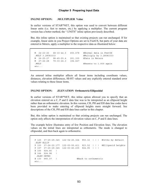
INLINE OPTION: .MULTIPLIER Value<br />
In earlier versions of <strong>STAR*NET</strong>, this option was used to convert between different<br />
linear units (i.e. feet to meters, etc.) by applying a multiplier. The current program<br />
version has a better method, the “.UNITS” inline option previously described.<br />
But, this inline option is maintained so that existing projects can run unchanged. If for<br />
example, linear units in you Project Options are set to FeetUS, but parts of your data are<br />
entered in Meters, apply a multiplier to the respective data as illustrated below:<br />
M 24-23-25 68-33-44.5 655.678 #Normal data in FeetUS<br />
.MULT 3.28083333 #Multiply by 3.28083333<br />
M 26-25-27 98-45-55.4 201.335 #Data in Meters<br />
M 27-26-28 79-33-24.3 194.667<br />
.MULT #Resets to 1.000 again<br />
etc...<br />
An entered inline multiplier affects all linear items including coordinate values,<br />
distances, elevation differences, HI-HT values and any explicitly entered standard error<br />
values relating to these linear items.<br />
INLINE OPTION: .ELEVATION Orthometric/Ellipsoidal<br />
In earlier versions of <strong>STAR*NET</strong>, this inline option allowed you to specify that an<br />
elevation entered on a C, P and E data line was to be intrepreted as an ellipsoid height<br />
rather than an orthometric elevation. In this version, CH, PH and EH data line codes have<br />
been provided to make entering of ellipsoid heights more straight forward. See<br />
descriptions of the CH, PH and EH data lines earlier in this chapter.<br />
But, this inline option is maintained so that existing projects can run unchanged. The<br />
option only affects the interpretation of elevation values on C, P and E data lines.<br />
The example below illustrates entry of few Position and Elevation lines. The elevation<br />
values on the initial lines are intrepreted as orthometric. The mode is changed to<br />
ellipsoidal, and then back again to orthometric.<br />
P 125 37-25-29.345 122-04-25.324 955.32 ! ! ! #Ortho by default<br />
.ELEV ELLIP<br />
P 153 37-26-22.177 122-03-55.411 923.52 ! ! ! #Ellipsoid heights<br />
P 157 37-25-29.345 122-03-45.235 924.95 ! ! !<br />
E 165 924.66 !<br />
E 166 924.98 !<br />
.ELEV ORTHO<br />
E 133 955.37 ! #Back to orthometric<br />
etc...<br />
93


