

STAR*NET V6 - Circe
STAR*NET V6 - Circe
STAR*NET V6 - Circe

Create successful ePaper yourself
Turn your PDF publications into a flip-book with our unique Google optimized e-Paper software.
INLINE OPTION: .DELTA ON/OFF<br />
Chapter 5 Preparing Input Data<br />
This inline option allows you to change the “Distance/Vertical Data Type” default set in<br />
the Project Options/General dialog. This option relates only to 3D-formatted data. When<br />
set to “OFF”, subsequent data will be interpreted as slope distance and zenith angle<br />
observations. When set to “ON”, subsequent data will be interpreted as horizontal<br />
distance and elevation difference observations.<br />
For example, if the “Distance/Vertical Data Type” option in the Project Options is set to<br />
the “Slope Dist/Zenith Angle” setting, the following inline options illustrate how to<br />
change to the input data to the “Horiz Dist/Elev Diff” mode, and then back again:<br />
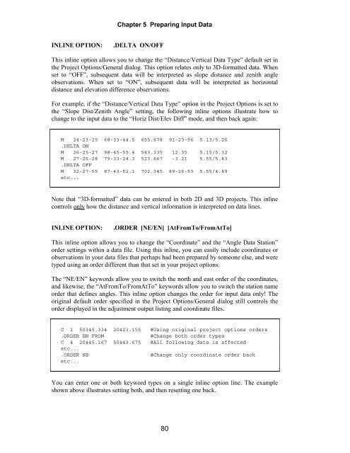
M 24-23-25 68-33-44.5 655.678 91-23-56 5.13/5.25<br />
.DELTA ON<br />
M 26-25-27 98-45-55.4 543.335 12.35 5.15/5.32<br />
M 27-26-28 79-33-24.3 523.667 -3.21 5.55/5.43<br />
.DELTA OFF<br />
M 32-27-55 87-43-52.1 702.345 89-26-53 5.55/4.89<br />
etc...<br />
Note that “3D-formatted” data can be entered in both 2D and 3D projects. This inline<br />
controls only how the distance and vertical information is interpreted on data lines.<br />
INLINE OPTION: .ORDER [NE/EN] [AtFromTo/FromAtTo]<br />
This inline option allows you to change the “Coordinate” and the “Angle Data Station”<br />
order settings within a data file. Using this inline, you can easily include coordinates or<br />
observations in your data files that perhaps had been prepared by someone else, and were<br />
typed using an order different than that set in your project options.<br />
The “NE/EN” keywords allow you to switch the north and east order of the coordinates,<br />
and likewise, the “AtFromTo/FromAtTo” keywords allow you to switch the station name<br />
order that defines angles. This inline option changes the order for input data only! The<br />
original default order specified in the Project Options/General dialog still controls the<br />
order displayed in the adjustment output listing and coordinate files.<br />
C 1 50345.334 20423.155 #Using original project options orders<br />
.ORDER EN FROM #Change both order types<br />
C 4 20445.167 50443.675 #All following data is affected<br />
etc...<br />
.ORDER NE #Change only coordinate order back<br />
etc...<br />
You can enter one or both keyword types on a single inline option line. The example<br />
shown above illustrates setting both, and then resetting one back.<br />
80


