

STAR*NET V6 - Circe
STAR*NET V6 - Circe
STAR*NET V6 - Circe

Create successful ePaper yourself
Turn your PDF publications into a flip-book with our unique Google optimized e-Paper software.
Chapter 4 Options<br />
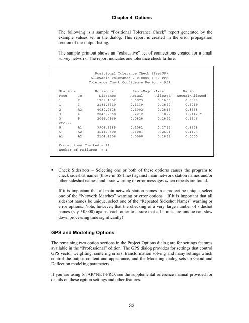
The following is a sample “Positional Tolerance Check” report generated by the<br />
example values set in the dialog. This report is created in the error propagation<br />
section of the output listing.<br />
The sample printout shows an “exhaustive” set of connections created for a small<br />
survey network. The report indicates one tolerance check failure.<br />
Positional Tolerance Check (FeetUS)<br />
Allowable Tolerance = 0.0800 + 50 PPM<br />
Tolerance Check Confidence Region = 95%<br />
Stations Horizontal Semi-Major-Axis Ratio<br />
From To Distance Actual Allowed Actual/Allowed<br />
1 2 1709.4352 0.0973 0.1655 0.5878<br />
1 3 2184.5310 0.1139 0.1892 0.6019<br />
2 A2 4030.2628 0.1002 0.2815 0.3558<br />
3 4 2043.7068 0.2212 0.1822 1.2142 *<br />
3 5 2044.7969 0.0828 0.1822 0.4546<br />
etc...<br />
5 A1 3904.3385 0.1081 0.2752 0.3928<br />
5 A2 3641.8400 0.1081 0.2621 0.4125<br />
A1 A2 2104.1206 0.0000 0.1852 0.0000<br />
Connections Checked = 21<br />
Number of Failures = 1<br />
Check Sideshots – Selecting one or both of these options causes the program to<br />
check sideshot names (those in SS lines) against main network station names and/or<br />
other sideshot names, and issue warning or error messages when repeats are found.<br />
If it is important that all main network station names in a project be unique, select<br />
one of the “Network Matches” warning or error options. If it is important that all<br />
sideshot names be unique, select one of the “Repeated Sideshot Names” warning or<br />
error options. Note, however, that the checking of a very large number of sideshot<br />
names (say 50,000) against each other to assure that all names are unique can slow<br />
down processing time significantly!<br />
GPS and Modeling Options<br />
The remaining two option sections in the Project Options dialog are for settings features<br />
available in the “Professional” edition. The GPS dialog provides for settings that control<br />
GPS vector weighting, centering errors, transformation solving and many settings which<br />
control the output content and appearance, and the Modeling dialog sets up Geoid and<br />
Deflection modeling parameters.<br />
If you are using <strong>STAR*NET</strong>-PRO, see the supplemental reference manual provided for<br />
details on these option settings and other features.<br />
33


