

STAR*NET V6 - Circe
STAR*NET V6 - Circe
STAR*NET V6 - Circe

Create successful ePaper yourself
Turn your PDF publications into a flip-book with our unique Google optimized e-Paper software.
Chapter 10 Adjustments in Grid Coordinate Systems<br />
10.9 Entering a Geoid Height and Vertical Deflections<br />
In general, you work with elevations in <strong>STAR*NET</strong>, which is the height above the geoid<br />
usually determined by differential leveling. However, in the grid calculations performed<br />
during an adjustment, distances are reduced to the ellipsoid, not the geoid. Therefore<br />
<strong>STAR*NET</strong> must know the heights of points above the ellipsoid.<br />
The geoid height at a station is defined as the height above the ellipsoid minus the height<br />
above the geoid. Therefore, by entering the average geoid height for your project, the<br />
program can determine reasonably accurate ellipsoid height for all points to perform the<br />
necessary geodetic calculations.<br />
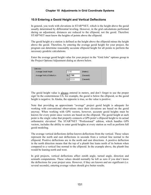
Enter the average geoid height value for your project in the “Grid Jobs” options group in<br />
the Project Options/Adjustment dialog as shown below.<br />
The geoid height value is always entered in meters, and don’t forget to use the proper<br />
sign! In the conterminous US, for example, the geoid is below the ellipsoid, so the geoid<br />
height is negative. In Alaska, the opposite is true, so the value is positive.<br />
Note that providing an approximate “average” project geoid height is adequate for<br />
working with conventional observations since their elevations are based on the geoid<br />
anyway. When working with GPS vectors, however, accurate geoid heights must be<br />
known for every point since vectors are based on the ellipsoid. The geoid height at each<br />
point is the single value that properly connects a GPS point’s ellipsoid height to its actual<br />
orthometric elevation! The <strong>STAR*NET</strong> “Professional” edition, which handles GPS<br />
vectors, includes the ability to enter geoid heights at every station as well as perform full<br />
geoid modeling.<br />
The average vertical deflections define known deflections from the vertical. These values<br />
represent the north and east deflections in seconds from a vertical line normal to the<br />
ellipsoid. Positive deflections are in the north and east directions. A positive deflection<br />
in the north direction means that the top of a plumb line leans north of its bottom when<br />
compared to a vertical line normal to the ellipsoid. In the example above, the plumb line<br />
would be leaning north and west.<br />
In grid projects, vertical deflections affect zenith angle, turned angle, direction and<br />
azimuth computations. These values should normally be left as zero if you don’t know<br />
the deflections for your project area. However, if they are known and are significant (i.e.<br />
several seconds), entering average values should give better results.<br />
151


