Ch. 3 Land - Environment Yukon
Ch. 3 Land - Environment Yukon
Ch. 3 Land - Environment Yukon

Create successful ePaper yourself
Turn your PDF publications into a flip-book with our unique Google optimized e-Paper software.
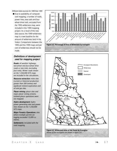
Different data sources for 1999 than 1995<br />
■ Due to availability of computerized<br />
mapping, a number of roads,<br />
power lines, tote trails and four<br />
wheel drive trails, excluded from<br />
the 1995 wilderness map, were<br />
included in the 1999 mapping<br />
project. As a result of the new<br />
data source, the 1999 wilderness<br />
map is a new baseline for the<br />
amount of wilderness land in the<br />
<strong>Yukon</strong>. Comparisons between the<br />
1995 and the 1999 maps and per<br />
cent of wilderness should not be<br />
made.<br />
Definitions of development<br />
used for mapping project<br />
Roads: all weather highways,<br />
two-wheel and four-wheel drive<br />
roads or tote trails, (excluding<br />
foot trails). Winter roads shown<br />
on the 1:250,000 NTS maps<br />
are included in the calculations.<br />
Resource extraction: mine sites<br />
(current or historical production<br />
greater than 500 tonnes) and<br />
significant mineral exploration and<br />
oil and gas sites.<br />
Placer mining: placer sites and<br />
major placer mining streams.<br />
Isolated placer operations were<br />
not mapped.<br />
Hydro development: hydro<br />
power generating sites and power<br />
lines shown on the 1:250,000<br />
NTS maps.<br />
Major Forestry Operations: sites<br />
where multiple permits for<br />
logging exceeded 15,000 cu<br />
metres.<br />
Settlements: included with the<br />
road mapping.<br />
Percent Wilderness<br />
100%<br />
80%<br />
60%<br />
40%<br />
20%<br />
0%<br />
Ecoregion Boundaries<br />
Wilderness<br />
Developed<br />
C H A P T E R 3 L A N D ❧ 3 7<br />
Natural<br />
Figure 3.3 Wilderness areas of the <strong>Yukon</strong> by Ecoregion<br />
Names of the ecoregions are shown in Figure 3.4<br />
Boreal Mountains and Plateaus<br />
British-Richardson Mountains<br />
Eagle Plains<br />
Fort MacPherson Plain<br />
Hyland Highland<br />
Klondike Plateau<br />
Liard Basin<br />
Mackenzie Mountains<br />
Mount Logan<br />
Muskwa Plateau<br />
North Ogilvie Mountains<br />
Old Crow Basin<br />
Old Crow Flats<br />
Peel River Plateau<br />
Pelly Mountains<br />
Ruby Ranges<br />
Selwyn Mountains<br />
St.Elias Mountains<br />
<strong>Yukon</strong> Coastal Plain<br />
<strong>Yukon</strong> Plateau-Central<br />
<strong>Yukon</strong> Plateau-North<br />
<strong>Yukon</strong> Southern Lakes<br />
<strong>Yukon</strong>-Stikine Highlands<br />
Figure 3.2 Percentage of Area of Wilderness by Ecoregion