Ch. 3 Land - Environment Yukon
Ch. 3 Land - Environment Yukon
Ch. 3 Land - Environment Yukon
You also want an ePaper? Increase the reach of your titles
YUMPU automatically turns print PDFs into web optimized ePapers that Google loves.
and time involved and the lack of<br />
available data. Developments<br />
excluded from both 1995 and<br />
1999 are: seismic lines, grazing<br />
lands, isolated dwellings, cabins,<br />
some placer operations, minor<br />
mineral exploration, and a number<br />
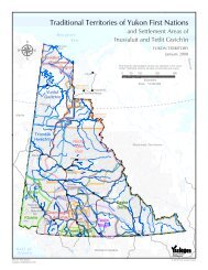
Figure 3.1 Wilderness areas in the <strong>Yukon</strong> Territory<br />
of power lines, smaller roads and<br />
trails or footpaths.<br />
■ As not all of the computerized<br />
data could be verified, there may<br />
be developments such as roads<br />
that are no longer in use and have<br />
reverted to wilderness. Alterna-<br />
tively, new roads that are not in<br />
the data base may have been<br />
missed. While this is a limitation of<br />
the wilderness map, overall, these<br />
mapping constraints likely balance<br />
out in terms of the total calculation<br />
of wilderness areas of the <strong>Yukon</strong>.<br />
Wilderness–areas with little human activity other than subsistence use or activities<br />
with low-scale development<br />
Natural–an intermediate category of ‘moderate’ wilderness. There may be evidence<br />
of human impacts such as tote trails, but in many aspects the land remains<br />
wilderness.<br />
Developed–this includes linear developments (such as roads), point developments<br />
(such as mine sites) and area developments (such as forest cut blocks).<br />
Technical Notes<br />
development primary secondary 4x2 4x4<br />
type highway highway road road trail mine hydro placer forestry<br />
developed<br />
category<br />
width (km)<br />
0-5 0-1 0-1 0-1 none 0-5 0-5 0-2 0-2<br />
natural<br />
category<br />
width (km)<br />
>5-10 1-8 1-8 1-5 0-1 >5-10 >5-10 >2-4 >2-4<br />
Because wilderness does not start at the edge of a mine site or highway, areas of<br />
varying widths have been added to accommodate for the transition zone between<br />
development and wilderness. The Technical Notes above show the widths of the<br />
areas included for the various types of development.<br />
wilderness<br />
77%<br />
developed<br />
8%<br />
3 6 ❧ Y U K O N S T A T E O F T H E E N V I R O N M E N T R E P O R T 1999<br />
natural<br />
15%


