Ch. 3 Land - Environment Yukon
Ch. 3 Land - Environment Yukon
Ch. 3 Land - Environment Yukon
You also want an ePaper? Increase the reach of your titles
YUMPU automatically turns print PDFs into web optimized ePapers that Google loves.
number of humans is immense. As<br />
countries complete the industrialization<br />
process, the world-wide demand for<br />
resources and land will multiply<br />
exponentially. These forecasts allude<br />
to a profound impact on the remaining<br />
areas of wilderness in the world.<br />
While at the beginning of the 20th century, wilderness was often seen<br />
as a frontier to be pushed back,<br />
many individuals now view natural<br />
and pristine areas as essential to<br />
the maintenance of a sustainable<br />
ecosystem. For the First Nation people<br />
who still have ties to the land, the vast<br />
undeveloped regions of the <strong>Yukon</strong> are<br />
their homeland with familiar trails,<br />
campsites, fishing camps, caches and<br />
hunting areas 2. Despite a growing<br />
individual awareness of the value<br />
of wilderness, an escalating world<br />
population and demand for resources<br />
are so great that, on a global scale,<br />
there is increasing stress on the<br />
remaining wilderness areas. In many<br />
countries of the world, wilderness areas<br />
have disappeared.<br />
The <strong>Environment</strong> Act recognizes<br />
wilderness as a natural resource with<br />
ecological as well as economic value.<br />
The Act provides enabling legislation<br />
for the establishment of Wilderness<br />
Management Areas to protect the<br />
wilderness resource. Currently, the<br />
approach is to use the <strong>Yukon</strong> Parks Act<br />
and the Protected Areas Strategy to<br />
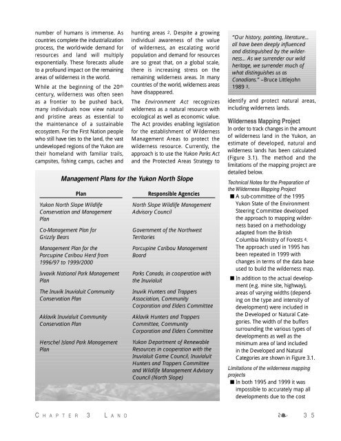
Management Plans for the <strong>Yukon</strong> North Slope<br />
Plan<br />
<strong>Yukon</strong> North Slope Wildlife<br />
Conservation and Management<br />
Plan<br />
Co-Management Plan for<br />
Grizzly Bears<br />
Management Plan for the<br />
Porcupine Caribou Herd from<br />
1996/97 to 1999/2000<br />
Ivvavik National Park Management<br />
Plan<br />
The Inuvik Inuvialuit Community<br />
Conservation Plan<br />
Aklavik Inuvialuit Community<br />
Conservation Plan<br />
Herschel Island Park Management<br />
Plan<br />
Responsible Agencies<br />
North Slope Wildlife Management<br />
Advisory Council<br />
Government of the Northwest<br />
Territories<br />
Porcupine Caribou Management<br />
Board<br />
Parks Canada, in cooperation with<br />
the Inuvialuit<br />
Inuvik Hunters and Trappers<br />
Association, Community<br />
Corporation and Elders Committee<br />
Aklavik Hunters and Trappers<br />
Committee, Community<br />
Corporation and Elders Committee<br />
<strong>Yukon</strong> Department of Renewable<br />
Resources in cooperation with the<br />
Inuvialuit Game Council, Inuvialuit<br />
Hunters and Trappers Committee<br />
and Wildlife Management Advisory<br />
Council (North Slope)<br />
“Our history, painting, literature…<br />
all have been deeply influenced<br />
and distinguished by the wilderness…<br />
As we surrender our wild<br />
heritage, we surrender much of<br />
what distinguishes us as<br />
Canadians.” –Bruce Littlejohn<br />
1989 3.<br />
identify and protect natural areas,<br />
including wilderness lands.<br />
Wilderness Mapping Project<br />
In order to track changes in the amount<br />
of wilderness land in the <strong>Yukon</strong>, an<br />
estimate of developed, natural and<br />
wilderness lands has been calculated<br />
(Figure 3.1). The method and the<br />
limitations of the mapping project are<br />
detailed below.<br />
Technical Notes for the Preparation of<br />
the Wilderness Mapping Project<br />
■ A sub-committee of the 1995<br />
<strong>Yukon</strong> State of the <strong>Environment</strong><br />
Steering Committee developed<br />
the approach to mapping wilderness<br />
based on a methodology<br />
adapted from the British<br />
Columbia Ministry of Forests 4.<br />
The approach used in 1995 has<br />
been repeated in 1999 with<br />
changes in terms of the data base<br />
used to build the wilderness map.<br />
■ In addition to the actual development<br />
(e.g. mine site, highway),<br />
areas of varying widths (depending<br />
on the type and intensity of<br />
development) were included in<br />
the Developed or Natural Categories.<br />
The width of the buffers<br />
surrounding the various types of<br />
developments as well as the<br />
minimum area of land included<br />
in the Developed and Natural<br />
Categories are shown in Figure 3.1.<br />
Limitations of the wilderness mapping<br />
projects<br />
■ In both 1995 and 1999 it was<br />
impossible to accurately map all<br />
developments due to the cost<br />
C H A P T E R 3 L A N D ❧ 3 5


