Ch. 3 Land - Environment Yukon
Ch. 3 Land - Environment Yukon
Ch. 3 Land - Environment Yukon

Create successful ePaper yourself
Turn your PDF publications into a flip-book with our unique Google optimized e-Paper software.
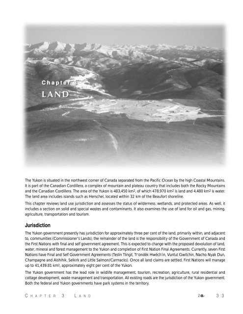
The <strong>Yukon</strong> is situated in the northwest corner of Canada separated from the Pacific Ocean by the high Coastal Mountains.<br />
It is part of the Canadian Cordillera, a complex of mountain and plateau country that includes both the Rocky Mountains<br />
and the Canadian Cordillera. The area of the <strong>Yukon</strong> is 483,450 km2, of which 478,970 km2 is land and 4,480 km2 is water.<br />
The land area includes islands such as Herschel, located within 32 km of the Beaufort shoreline.<br />
This chapter reviews land use jurisdiction and assesses the status of wilderness, wetlands, and protected areas. As well, it<br />
includes a section on solid and special wastes and contaminants. It also examines the use of land for oil and gas, mining,<br />
agriculture, transportation and tourism.<br />
Jurisdiction<br />
The <strong>Yukon</strong> government presently has jurisdiction for approximately three per cent of the land, primarily within, and adjacent<br />
to, communities (Commissioner’s <strong>Land</strong>s); the remainder of the land is the responsibility of the Government of Canada and<br />
the First Nations with final and self government agreement. This is expected to change with the proposed devolution of land,<br />
water, mineral and forest management to the <strong>Yukon</strong> and completion of First Nation Final Agreements. Currently, seven First<br />
Nations have Final and Self Government Agreements (Teslin Tlingit, Tr’ondëk Hwëch’in, Vuntut Gwitchin, Nacho Nyak Dun,<br />
<strong>Ch</strong>ampagne and Aishihik, Selkirk and Little Salmon/Carmacks). Once all land claims are settled, First Nations will manage<br />
up to 41,439.81 km2, approximately eight per cent of the <strong>Yukon</strong>.<br />
The <strong>Yukon</strong> government has the lead role in wildlife management, tourism, recreation, agriculture, rural residential and<br />
cottage development, waste management and transportation. All existing roads are the jurisdiction of the <strong>Yukon</strong> government.<br />
Both the federal and <strong>Yukon</strong> governments have park systems in the territory.<br />
C H A P T E R 3 L A N D ❧ 3 3
Carcross/Tagish First Nation<br />
<strong>Ch</strong>ampagne & Aishihik First Nations<br />
Kluane First Nation<br />
Kwanlin Dun First Nation<br />
Liard First Nation<br />
Little Salmon/Carmacks First Nation<br />
Nacho Nyak Dun First Nation<br />
With the devolution of land, water,<br />
mineral and forest management and<br />
resources to the <strong>Yukon</strong> government<br />
proposed for 2001, the administration<br />
and control of most land will devolve to<br />
the <strong>Yukon</strong> government. In preparation<br />
for the management of land and<br />
<strong>Yukon</strong> First Nations<br />
Ross River Dena Council<br />
Selkirk First Nation<br />
Ta’an Kwach’an Council<br />
Teslin Tlingit Council<br />
Tr’on dëk Hwëch’in First Nation<br />
Vuntut Gwitchin First Nation<br />
White River First Nation<br />
resources, the <strong>Yukon</strong> government<br />
proposes to develop mirror legislation<br />
to the federal statutes. The <strong>Yukon</strong><br />
government will also be proposing<br />
amendments to the <strong>Yukon</strong> Act to<br />
update and modernize the Act in line<br />
with devolution.<br />
Major Umbrella Final Agreement<br />
<strong>Land</strong> and Resource Management Committees and Boards<br />
■ <strong>Yukon</strong> Fish and Wildlife Management Board<br />
■ Salmon Sub-Committee<br />
■ Local Renewable Resources Councils (Recommends on fish and wildlife<br />
habitat and other renewable resources)<br />
■ <strong>Yukon</strong> Heritage Resources Board<br />
■ <strong>Yukon</strong> <strong>Land</strong> Use Planning Council (Recommends policy and priority<br />
planning regions)<br />
■ Regional <strong>Land</strong> Use Planning Commissions<br />
■ <strong>Yukon</strong> Development Assessment Board (Review of development projects)<br />
■ Kluane National Park Management Board<br />
“Let’s work side by side with traditional knowledge and the public for our<br />
future generation to be healthy and have what we’ve enjoyed in the past.<br />
I’d like to see our future was the same, to be enjoyed all our life, on this<br />
land that we live on. I’d like to see these two cultures side by side to respect<br />
each other’s knowledge.” –Roddy Blackjack, Little Salmon/Carmacks First<br />
Nation Elder<br />
Under the Umbrella Final Agreement,<br />
a number of joint government and First<br />
Nation boards and committees will<br />
contribute to the management of<br />
renewable resources, land, water, and<br />
heritage resources (see side bar).<br />
The <strong>Yukon</strong> North Slope is within the<br />
Inuvialuit Settlement Region. <strong>Environment</strong>al<br />
assessment and resource<br />
management in this region are carried<br />
out through joint Inuvialuit and<br />
government boards and committees.<br />
Management plans have been<br />
prepared to address specific wildlife and<br />
community issues as shown opposite.<br />
<strong>Environment</strong>al assessment for projects<br />
on federal lands or involving federal<br />
money or permits is the responsibility<br />
of the federal government, as are land<br />
use activities such as mining and<br />
forestry. It is expected that by 2001,<br />
environmental assessment in the <strong>Yukon</strong><br />
will take place under the Development<br />
Assessment Process (DAP). The parties<br />
are continuing to work towards<br />
completing the Development Assessment<br />
Process that fulfills the requirements<br />
of the UFA and is reflective of<br />
the needs of <strong>Yukon</strong>ers. Consultation<br />
on the next public draft of the legislation<br />
is expected to occur in 2000.<br />
3.1 Wilderness<br />
Wilderness means an area in the <strong>Yukon</strong><br />
where human activity has not<br />
significantly changed the environment<br />
or the ecosystem. It includes an area<br />
restored to natural condition (<strong>Yukon</strong><br />
<strong>Environment</strong> Act).<br />
Wilderness areas are being lost<br />
throughout the world as the human<br />
population continues to climb and the<br />
use of land and resources increases.<br />
Since 1900, the world’s population has<br />
multiplied almost fivefold and in 1999<br />
the population of the world reached six<br />
billion. Projections of the world<br />
population are 10 billion in the year<br />
2060 1. The ecological footprint of this<br />
3 4 ❧ Y U K O N S T A T E O F T H E E N V I R O N M E N T R E P O R T 1999
number of humans is immense. As<br />
countries complete the industrialization<br />
process, the world-wide demand for<br />
resources and land will multiply<br />
exponentially. These forecasts allude<br />
to a profound impact on the remaining<br />
areas of wilderness in the world.<br />
While at the beginning of the 20th century, wilderness was often seen<br />
as a frontier to be pushed back,<br />
many individuals now view natural<br />
and pristine areas as essential to<br />
the maintenance of a sustainable<br />
ecosystem. For the First Nation people<br />
who still have ties to the land, the vast<br />
undeveloped regions of the <strong>Yukon</strong> are<br />
their homeland with familiar trails,<br />
campsites, fishing camps, caches and<br />
hunting areas 2. Despite a growing<br />
individual awareness of the value<br />
of wilderness, an escalating world<br />
population and demand for resources<br />
are so great that, on a global scale,<br />
there is increasing stress on the<br />
remaining wilderness areas. In many<br />
countries of the world, wilderness areas<br />
have disappeared.<br />
The <strong>Environment</strong> Act recognizes<br />
wilderness as a natural resource with<br />
ecological as well as economic value.<br />
The Act provides enabling legislation<br />
for the establishment of Wilderness<br />
Management Areas to protect the<br />
wilderness resource. Currently, the<br />
approach is to use the <strong>Yukon</strong> Parks Act<br />
and the Protected Areas Strategy to<br />
Management Plans for the <strong>Yukon</strong> North Slope<br />
Plan<br />
<strong>Yukon</strong> North Slope Wildlife<br />
Conservation and Management<br />
Plan<br />
Co-Management Plan for<br />
Grizzly Bears<br />
Management Plan for the<br />
Porcupine Caribou Herd from<br />
1996/97 to 1999/2000<br />
Ivvavik National Park Management<br />
Plan<br />
The Inuvik Inuvialuit Community<br />
Conservation Plan<br />
Aklavik Inuvialuit Community<br />
Conservation Plan<br />
Herschel Island Park Management<br />
Plan<br />
Responsible Agencies<br />
North Slope Wildlife Management<br />
Advisory Council<br />
Government of the Northwest<br />
Territories<br />
Porcupine Caribou Management<br />
Board<br />
Parks Canada, in cooperation with<br />
the Inuvialuit<br />
Inuvik Hunters and Trappers<br />
Association, Community<br />
Corporation and Elders Committee<br />
Aklavik Hunters and Trappers<br />
Committee, Community<br />
Corporation and Elders Committee<br />
<strong>Yukon</strong> Department of Renewable<br />
Resources in cooperation with the<br />
Inuvialuit Game Council, Inuvialuit<br />
Hunters and Trappers Committee<br />
and Wildlife Management Advisory<br />
Council (North Slope)<br />
“Our history, painting, literature…<br />
all have been deeply influenced<br />
and distinguished by the wilderness…<br />
As we surrender our wild<br />
heritage, we surrender much of<br />
what distinguishes us as<br />
Canadians.” –Bruce Littlejohn<br />
1989 3.<br />
identify and protect natural areas,<br />
including wilderness lands.<br />
Wilderness Mapping Project<br />
In order to track changes in the amount<br />
of wilderness land in the <strong>Yukon</strong>, an<br />
estimate of developed, natural and<br />
wilderness lands has been calculated<br />
(Figure 3.1). The method and the<br />
limitations of the mapping project are<br />
detailed below.<br />
Technical Notes for the Preparation of<br />
the Wilderness Mapping Project<br />
■ A sub-committee of the 1995<br />
<strong>Yukon</strong> State of the <strong>Environment</strong><br />
Steering Committee developed<br />
the approach to mapping wilderness<br />
based on a methodology<br />
adapted from the British<br />
Columbia Ministry of Forests 4.<br />
The approach used in 1995 has<br />
been repeated in 1999 with<br />
changes in terms of the data base<br />
used to build the wilderness map.<br />
■ In addition to the actual development<br />
(e.g. mine site, highway),<br />
areas of varying widths (depending<br />
on the type and intensity of<br />
development) were included in<br />
the Developed or Natural Categories.<br />
The width of the buffers<br />
surrounding the various types of<br />
developments as well as the<br />
minimum area of land included<br />
in the Developed and Natural<br />
Categories are shown in Figure 3.1.<br />
Limitations of the wilderness mapping<br />
projects<br />
■ In both 1995 and 1999 it was<br />
impossible to accurately map all<br />
developments due to the cost<br />
C H A P T E R 3 L A N D ❧ 3 5
and time involved and the lack of<br />
available data. Developments<br />
excluded from both 1995 and<br />
1999 are: seismic lines, grazing<br />
lands, isolated dwellings, cabins,<br />
some placer operations, minor<br />
mineral exploration, and a number<br />
Figure 3.1 Wilderness areas in the <strong>Yukon</strong> Territory<br />
of power lines, smaller roads and<br />
trails or footpaths.<br />
■ As not all of the computerized<br />
data could be verified, there may<br />
be developments such as roads<br />
that are no longer in use and have<br />
reverted to wilderness. Alterna-<br />
tively, new roads that are not in<br />
the data base may have been<br />
missed. While this is a limitation of<br />
the wilderness map, overall, these<br />
mapping constraints likely balance<br />
out in terms of the total calculation<br />
of wilderness areas of the <strong>Yukon</strong>.<br />
Wilderness–areas with little human activity other than subsistence use or activities<br />
with low-scale development<br />
Natural–an intermediate category of ‘moderate’ wilderness. There may be evidence<br />
of human impacts such as tote trails, but in many aspects the land remains<br />
wilderness.<br />
Developed–this includes linear developments (such as roads), point developments<br />
(such as mine sites) and area developments (such as forest cut blocks).<br />
Technical Notes<br />
development primary secondary 4x2 4x4<br />
type highway highway road road trail mine hydro placer forestry<br />
developed<br />
category<br />
width (km)<br />
0-5 0-1 0-1 0-1 none 0-5 0-5 0-2 0-2<br />
natural<br />
category<br />
width (km)<br />
>5-10 1-8 1-8 1-5 0-1 >5-10 >5-10 >2-4 >2-4<br />
Because wilderness does not start at the edge of a mine site or highway, areas of<br />
varying widths have been added to accommodate for the transition zone between<br />
development and wilderness. The Technical Notes above show the widths of the<br />
areas included for the various types of development.<br />
wilderness<br />
77%<br />
developed<br />
8%<br />
3 6 ❧ Y U K O N S T A T E O F T H E E N V I R O N M E N T R E P O R T 1999<br />
natural<br />
15%
Different data sources for 1999 than 1995<br />
■ Due to availability of computerized<br />
mapping, a number of roads,<br />
power lines, tote trails and four<br />
wheel drive trails, excluded from<br />
the 1995 wilderness map, were<br />
included in the 1999 mapping<br />
project. As a result of the new<br />
data source, the 1999 wilderness<br />
map is a new baseline for the<br />
amount of wilderness land in the<br />
<strong>Yukon</strong>. Comparisons between the<br />
1995 and the 1999 maps and per<br />
cent of wilderness should not be<br />
made.<br />
Definitions of development<br />
used for mapping project<br />
Roads: all weather highways,<br />
two-wheel and four-wheel drive<br />
roads or tote trails, (excluding<br />
foot trails). Winter roads shown<br />
on the 1:250,000 NTS maps<br />
are included in the calculations.<br />
Resource extraction: mine sites<br />
(current or historical production<br />
greater than 500 tonnes) and<br />
significant mineral exploration and<br />
oil and gas sites.<br />
Placer mining: placer sites and<br />
major placer mining streams.<br />
Isolated placer operations were<br />
not mapped.<br />
Hydro development: hydro<br />
power generating sites and power<br />
lines shown on the 1:250,000<br />
NTS maps.<br />
Major Forestry Operations: sites<br />
where multiple permits for<br />
logging exceeded 15,000 cu<br />
metres.<br />
Settlements: included with the<br />
road mapping.<br />
Percent Wilderness<br />
100%<br />
80%<br />
60%<br />
40%<br />
20%<br />
0%<br />
Ecoregion Boundaries<br />
Wilderness<br />
Developed<br />
C H A P T E R 3 L A N D ❧ 3 7<br />
Natural<br />
Figure 3.3 Wilderness areas of the <strong>Yukon</strong> by Ecoregion<br />
Names of the ecoregions are shown in Figure 3.4<br />
Boreal Mountains and Plateaus<br />
British-Richardson Mountains<br />
Eagle Plains<br />
Fort MacPherson Plain<br />
Hyland Highland<br />
Klondike Plateau<br />
Liard Basin<br />
Mackenzie Mountains<br />
Mount Logan<br />
Muskwa Plateau<br />
North Ogilvie Mountains<br />
Old Crow Basin<br />
Old Crow Flats<br />
Peel River Plateau<br />
Pelly Mountains<br />
Ruby Ranges<br />
Selwyn Mountains<br />
St.Elias Mountains<br />
<strong>Yukon</strong> Coastal Plain<br />
<strong>Yukon</strong> Plateau-Central<br />
<strong>Yukon</strong> Plateau-North<br />
<strong>Yukon</strong> Southern Lakes<br />
<strong>Yukon</strong>-Stikine Highlands<br />
Figure 3.2 Percentage of Area of Wilderness by Ecoregion
ECOZONE ECOREGION CODE<br />
Pacific Maritime Mount Logan 184<br />
Southern Arctic <strong>Yukon</strong> Coastal Plain 32<br />
Taiga Plain Peel River Plateau 51<br />
Fort Macpherson Plain 53<br />
Muskwa Plateau 66<br />
Taiga Cordillera British Richardson Mountains 165<br />
Old Crow Basin 166<br />
Old Crow Flats 167<br />
North Ogilvie Mountains 168<br />
Eagle Plains 169<br />
Mackenzie Mountains 170<br />
Selwyn Mountains 171<br />
Boreal Cordillera Klondike Plateau 172<br />
Saint Elias Mountains 173<br />
Ruby Ranges 174<br />
<strong>Yukon</strong> Plateau-Central 175<br />
<strong>Yukon</strong> Plateau-North 176<br />
<strong>Yukon</strong> Southern Lakes 177<br />
Pelly Mountains 178<br />
<strong>Yukon</strong>-Stikine Highlands 179<br />
Boreal Mountains And Plateaus 180<br />
Liard Basin 181<br />
Hyland Highland 182<br />
Figure 3.4 Ecoregions of the <strong>Yukon</strong><br />
* <strong>Yukon</strong> ecoregions and code numbers are part of a national<br />
framework for the classification of ecoregions.<br />
Wilderness <strong>Land</strong>s in the <strong>Yukon</strong><br />
The <strong>Yukon</strong> has vast areas of<br />
undeveloped land. Approximately 77<br />
per cent of the territory is within the<br />
‘wilderness’ category (Figure 3.1).<br />
Figures 3.2 and 3.3 illustrate the<br />
amount of wilderness, natural and<br />
developed land in each ecoregion.<br />
Ecoregions with the most wilderness<br />
are: the <strong>Yukon</strong> Plateau North,<br />
MacKenzie Mountains, North Ogilvie<br />
Mountains and Selwyn Mountains.<br />
Three ecoregions, the Klondike Plateau,<br />
<strong>Yukon</strong> Plateau North and <strong>Yukon</strong><br />
Southern Lakes contain the most<br />
development. The Klondike Plateau<br />
has substantial areas of placer mining,<br />
while the <strong>Yukon</strong> Southern Lakes<br />
ecoregion is dominated by development<br />
in and around the City of<br />
Whitehorse.<br />
3.2 Protected Areas<br />
“Our shared relationship with the<br />
northern land, water, air and life<br />
forms defines our character, sustains<br />
our spirits and unites us as people of<br />
the <strong>Yukon</strong>.<br />
We have a duty to protect the<br />
ecosystems and natural processes that<br />
support this relationship.<br />
We will meet this responsibility for the<br />
benefit of ourselves and our children,<br />
and also for the benefit of other life<br />
forms and the earth as a whole – for<br />
bio-diversity and the intrinsic value of<br />
wilderness.<br />
We will use the <strong>Yukon</strong> Protected Areas<br />
Strategy to guide us as we set up a<br />
network of protected areas based on<br />
ecosystem management, conservation<br />
biology, sustainable economies and<br />
values and knowledge of <strong>Yukon</strong><br />
people.”–Vision Statement of the<br />
<strong>Yukon</strong> Protected Areas Strategy 1.<br />
The <strong>Yukon</strong> Protected Areas Strategy,<br />
approved in 1998, guides the establishment<br />
of a system of protected areas<br />
by:<br />
3 8 ❧ Y U K O N S T A T E O F T H E E N V I R O N M E N T R E P O R T 1999
■ protecting core areas within each<br />
ecoregion to represent the ecological<br />
diversity of the <strong>Yukon</strong>; and<br />
■ protecting special areas which<br />
contain important wildlife and<br />
habitat values, uncommon landforms<br />
and natural features, special<br />
cultural, heritage and spiritual<br />
values, special outdoor recreation<br />
values or wilderness areas with<br />
intact ecosystems.<br />
The representative core protected areas<br />
are very important. They must be able<br />
to support sustainable populations of<br />
plants and animals for the foreseeable<br />
future and longer, survive climate<br />
fluctuations, disease and provide a<br />
future gene pool. The four criteria used<br />
to select the representative core<br />
protected areas are:<br />
■ representation of the ecosystem<br />
diversity of the ecoregion (Figure<br />
3.5);<br />
■ naturalness with few human<br />
caused disturbances;<br />
■ ecological viability on a long term<br />
basis; and<br />
■ research and education values.<br />
In 1999 the <strong>Yukon</strong> government set up<br />
a Protected Areas Secretariat (PAS) to<br />
coordinate the planning and establishment<br />
of protected areas 2.<br />
Parks and other types of protected<br />
areas in the <strong>Yukon</strong> may be established<br />
by federal agencies (Parks Canada or<br />
What is a Protected Area?<br />
An area of land and/or sea<br />
especially dedicated to the<br />
protection and maintenance of<br />
biological diversity, and of natural<br />
and associated cultural resources,<br />
and managed through legal or<br />
other means (World Conservation<br />
Union) 3.<br />
WORLD CONSERVATION UNION 1 (IUCN) CLASSIFICATIONS<br />
Categories I , II, III, are fully protected as per Goal One 2 (44,433 km 2 )<br />
Category IV is protected as per Goal Two 3 (10,651 km 2 )<br />
IUCN Category I and II: Strict Nature Preserve,<br />
Wilderness Areas, National Parks (44,252 km 2 )<br />
1 Herschel Island Territorial Park 116<br />
2 Fishing Branch Wilderness Preserve 5,400<br />
3 Tombstone Territorial Park 2,164<br />
4 Kluane National Park 22,015<br />
5 Vuntut National Park 4,387<br />
6 Ivvavik National Park 10,170<br />
IUCN Category III: Natural Monument (181 km 2 )<br />
7 Fishing Branch Ecological Reserve 165<br />
8 Coal River Springs Ecological Reserve 16<br />
IUCN Category IV: Habitat /Species Management Areas (10,651 km 2 )<br />
9 Old Crow Flats Special Management Area 7,785<br />
10 Horseshoe Slough Habitat Protection Area 79<br />
11 Ddhaw Ghro Habitat Protection Area 3 1,595<br />
12 Llutsaw Wetlands Habitat Protection Area 31<br />
13 Nordenskiold Wetlands Habitat Protection Area 76<br />
14 Ta’Tla Mun Special Management Area 32<br />
15 Nisutlin River Delta National Wildlife Area 53<br />
16 Fishing Branch Habitat Protection Area 1,000<br />
ICUN Category VI (0.55 km 2 )<br />
17 Sha'washe Special Management Area 0.55<br />
Unassigned under the IUCN System (6,450 km 2 )<br />
18 Kluane Wildlife Sanctuary 6450<br />
1 <strong>Ch</strong>anged in 1990 from the International Union for the Conservation of Nature. The acronym did not change.<br />
2 Goals as per the Protected Area Strategy<br />
3 With the exception of Fishing Branch Habitat Protected Area, these areas are currently withdrawn from<br />
mineral activity (status as of 1999). Status is subject to management planning<br />
Figure 3.5 <strong>Yukon</strong> Protected Areas and Sanctuaries<br />
The classification of protected areas in the <strong>Yukon</strong> is based on categories established by<br />
the World Conservation Union, an international organization. The classifications are<br />
generally accepted world-wide.<br />
C H A P T E R 3 L A N D ❧ 3 9
the Canadian Wildlife Service), or<br />
through four <strong>Yukon</strong> government agencies<br />
(Parks and Outdoor Recreation,<br />
Wildlife, Heritage, and <strong>Environment</strong>al<br />
Protection branches).<br />
The guiding principles for establishing<br />
the protected areas network begin with<br />
ecological integrity. Through a process<br />
of public participation, partnerships,<br />
accountability, quality of information<br />
and coordination, the network will<br />
respect all values, recognizing economic<br />
interests and contributing to<br />
sustainable development.<br />
Process to Establish<br />
Protected Areas<br />
1. The Protected Areas Secretariat<br />
identifies the first ecoregions<br />
and areas of interest.<br />
2. Local planning team is<br />
established in the First Nation<br />
Traditional Territory to work<br />
with community stakeholders,<br />
and the <strong>Yukon</strong> public.<br />
3. Local planning team identifies<br />
the study area.<br />
4. Government reviews and<br />
approves the study area.<br />
5. Local planning team completes<br />
the proposal for the protected<br />
area.<br />
6. Review by the Development<br />
Assessment Process.<br />
7. Final government (cabinet)<br />
review and approval<br />
8. Designation of the protected<br />
area.<br />
9. Preparation of a management<br />
plan and submission to<br />
government for approval.<br />
10. Periodic review and update of<br />
the management plan every five<br />
years.<br />
Protected areas in the <strong>Yukon</strong> range<br />
from relatively small ecological areas to<br />
extensive wilderness preserves. Some<br />
reserves in the <strong>Yukon</strong> have strict<br />
provisions for preservation of the<br />
complete ecosystem; others include<br />
only provisions to limit wildlife<br />
harvesting.<br />
<strong>Yukon</strong> protected areas and sanctuaries<br />
are shown in Figure 3.5 and the<br />
ecoregions of the <strong>Yukon</strong> are shown in<br />
Figure 3.4.<br />
Some ecoregions are well represented<br />
in the protected areas network (Figure<br />
3.6). The priority regions for the<br />
establishment of protected areas are<br />
the British–Richardson Mountains,<br />
Eagle Plains, Peel River Plateau and<br />
Fort MacPherson in the north and the<br />
Southern Lakes and Pelly Mountains.<br />
A network of protected areas will<br />
maintain bio-diversity, protect wildlife<br />
and watersheds, preserve unique,<br />
natural, scenic, historic and cultural<br />
areas, preserve the genetic diversity of<br />
species, and preserve wilderness.<br />
Cooperation between different sectors<br />
of government and industry is<br />
important to the establishment of<br />
protected areas which meet the<br />
objectives of the strategy. One issue<br />
which has been raised relates to mining.<br />
Though in many cases mining claims<br />
have lapsed in proposed park areas,<br />
some staking on or adjacent to<br />
proposed protected areas has occurred.<br />
<strong>Ch</strong>apter 10 of the Tr’ondëk Hwëch’in<br />
Final Agreement outlines the process<br />
for establishing the Tombstone Territorial<br />
Park, and a study area was established<br />
in April of 1997. A steering<br />
committee was struck in 1999 to<br />
recommend a final park boundary.<br />
There were 380 valid mineral claims<br />
Figure 3.6 Representation of Ecoregions in the Protected Area Network<br />
4 0 ❧ Y U K O N S T A T E O F T H E E N V I R O N M E N T R E P O R T 1999
within the study area in February 1998,<br />
and some of the claim holders have<br />
let their holdings lapse. In the fall of<br />
1999, there were 75 valid quartz claims<br />
within the draft park boundary. In<br />
December 1999, the <strong>Yukon</strong> and<br />
Tr’ondëk Hwëch’in governments<br />
approved the park boundary and permanent<br />
mineral staking withdrawal will<br />
be requested.<br />
In the summer of 1999, a lapsed mineral<br />
interest was re-staked (6 claims)<br />
within an area of interest for “Goal<br />
one” protection under the <strong>Yukon</strong><br />
Protected Areas Strategy. The location<br />
of the claims within the headwaters<br />
of the Fishing Branch River, has raised<br />
concerns regarding the potential risk to<br />
water quality. In December 1999 the<br />
<strong>Yukon</strong> government approved the entire<br />
Fishing Branch watershed as a Wilderness<br />
Preserve. The existing mineral<br />
rights will be respected.<br />
Protected areas: A Canadian and<br />
Broader Perspective<br />
The Government of Canada issued a<br />
Statement of Commitment to complete<br />
Canada’s Network of Protected Areas<br />
by the year 2000. This commitment to<br />
complete a system of representative<br />
parks in each jurisdiction requires the<br />
cooperation of federal, provincial, and<br />
territorial governments 4.<br />
The <strong>Yukon</strong> still needs adequate<br />
representation in 16 of its 23 ecological<br />
regions according to the <strong>Yukon</strong> Parks<br />
System Plan and the <strong>Yukon</strong> Protected<br />
Areas Strategy. The National Parks<br />
System Plan guides Parks Canada in<br />
establishing parks. Under this system,<br />
one of the five natural regions in the<br />
<strong>Yukon</strong> is not currently represented by a<br />
national park. Parks Canada has<br />
identified the Wolf Lake candidate area<br />
in the Northern Interior Mountains and<br />
Plateau Natural Region for further<br />
assessment in 1999.<br />
First Nations are playing a key role in<br />
establishing parks and protected areas<br />
in the <strong>Yukon</strong>. The designation of Special<br />
Management Areas (SMAs) under the<br />
<strong>Yukon</strong> land claim protect areas of<br />
cultural and environmental significance.<br />
The extent of the influence of the land<br />
claim agreements is clear as only one<br />
protected area, Coal River Springs, has<br />
been designated outside the land claim<br />
process.<br />
Non-government agencies, such as the<br />
World Wildlife Fund and the Canadian<br />
Parks and Wilderness Society, research<br />
and lobby for areas in need of<br />
preservation around the world. Major<br />
non-governmental initiatives for the<br />
<strong>Yukon</strong> include the World Wildlife<br />
Fund’s Endangered Spaces Campaign,<br />
the Yellowstone to <strong>Yukon</strong> Project,<br />
<strong>Yukon</strong> Wildlands Project and the<br />
Caribou Commons Project.<br />
Joint initiatives and meetings between<br />
private industry, government and<br />
environmental groups are the start of a<br />
cooperative approach for the<br />
establishment of protected areas.<br />
PROGRESS & CHALLENGES<br />
Progress since 1995<br />
■ <strong>Yukon</strong> Protected Areas Strategy<br />
adopted December 1998.<br />
■ Protected Areas Secretariat<br />
established March 1999.<br />
■ There is adequate parks and<br />
protected area representation<br />
within seven of the 23<br />
ecoregions of the <strong>Yukon</strong>. These<br />
protected areas meet Goal One<br />
of the Protected Area Strategy as<br />
there is a representative core<br />
area protected within each<br />
ecoregion.<br />
■ Four ecoregions have some<br />
representation in the <strong>Yukon</strong><br />
protected areas network.<br />
■ Seven new protected areas<br />
established since 1995<br />
(Tombstone Territorial Park,<br />
Fishing Branch Wilderness<br />
Preserve, and the Ta’tla Mun<br />
Special Management Area) and<br />
four Habitat Protection Areas<br />
(Nordenskiold Wetlands, Ddhaw<br />
Ghro, Lhutsaw Wetlands and<br />
Fishing Branch Habitat Protected<br />
Area).<br />
■ 9.3 per cent of the <strong>Yukon</strong> was<br />
protected in 1999 according to<br />
Categories I to III of the World<br />
Conservation Union; an<br />
additional 2.2 per cent is interim<br />
protected.<br />
<strong>Ch</strong>allenges<br />
■ Following consultation with First<br />
Nation governments and the<br />
public, oil and gas land sales were<br />
held in 1999 in the Eagle Plains<br />
Basin. An area was exempted<br />
from oil and gas land sales for<br />
future protected areas work.<br />
Additional oil and gas land sales<br />
in the area are contemplated for<br />
2000. Areas to be exempted for<br />
protected areas planning remain<br />
under discussion. There is the<br />
potential that lands required for<br />
protected areas planning may be<br />
affected by the 2000 sale.<br />
■ Obtaining interim protection of<br />
areas of interests is recognized as<br />
a challenge.<br />
■ 16 out of the 23 ecoregions are<br />
not adequately represented by<br />
protected areas.<br />
3.3 Oil and Gas Industry<br />
The <strong>Yukon</strong> is entering a new era in the<br />
management of its oil and gas resources<br />
(Figure 3.7). Until recently, the<br />
Government of Canada owned and<br />
managed oil and gas in the <strong>Yukon</strong>. In the<br />
fall of 1998, the <strong>Yukon</strong> government<br />
assumed provincial-like responsibility for<br />
oil and gas resources and is establishing<br />
a competitive oil and gas regime.<br />
<strong>Yukon</strong> First Nations are also assuming<br />
responsibilities for oil and gas through<br />
land claim agreements. The <strong>Yukon</strong><br />
C H A P T E R 3 L A N D ❧ 4 1
government has formed a partnership<br />
with First Nations and together the parties<br />
are pursuing the development of a<br />
common oil and gas regime. Under<br />
this common framework of legislation,<br />
regulations and policies there will be<br />
one set of rules for exploration and<br />
development. The core component of<br />
the common regime–the <strong>Yukon</strong> Oil and<br />
Gas Act–was enacted in 1998. A number<br />
of the key regulations have been<br />
developed and others are being developed.<br />
The existing regulations apply to<br />
the exploration stage and are regarded<br />
as very strict. They contain provisions<br />
that are not covered in other jurisdictions.<br />
For example, financial deposits<br />
are required to guarantee that abandonment<br />
and clean-up of wells will be<br />
conducted properly.<br />
As conventional supplies of oil and gas<br />
dwindle in Western Canada and<br />
companies seek alternative sources,<br />
exploration in the north becomes more<br />
favourable. <strong>Yukon</strong> is situated at the<br />
Figure 3.7 Oil and Gas Potential in the <strong>Yukon</strong><br />
<strong>Yukon</strong> contains eight sedimentary basins with potential to host oil and gas deposits. Each<br />
basin has its own unique geological history and character. Seventy-one wells have<br />
been drilled in the <strong>Yukon</strong> and most of these are located in the Liard Plateau, Peel Plateau,<br />
and Eagle Plain basins. The remaining five basins–Bonnet Plume, Kandik, Old Crow,<br />
Whitehorse Trough, and Coastal Plain–are virtually unexplored. There is also considerable<br />
oil and gas potential in the Beaufort Sea off the <strong>Yukon</strong>’s north coast.<br />
periphery of oil and gas producing<br />
regions with Alberta and British<br />
Columbia to the south, the Northwest<br />
Territories to the east, and Alaska to<br />
the west. Activity and infrastructure in<br />
Alberta and British Columbia extend<br />
into the southeast <strong>Yukon</strong> and<br />
opportunities exist for it to move<br />
northward.<br />
Current exploration interest is largely<br />
focused on the Liard Plateau in the<br />
southeast corner of the <strong>Yukon</strong> where<br />
one producing field is located. The best<br />
prospects are expected to be large<br />
deep gas pools similar to the producing<br />
field at Kotaneelee. There is also interest<br />
in Eagle Plains in north central <strong>Yukon</strong><br />
and a company is currently planning to<br />
produce crude oil from proven oil and<br />
gas reserves here for sale in the local<br />
<strong>Yukon</strong> market.<br />
In the past, seismic cutlines were six to<br />
eight metres wide which caused forest<br />
fragmentation and created access into<br />
otherwise remote areas. Through the<br />
assessment process, industry and the<br />
regulators are seeking to reduce access<br />
into the exploration areas. Technology<br />
has also evolved to significantly reduce<br />
access to and within exploration areas.<br />
Now cutlines are a maximum width of<br />
1.5 meters, and trees are limbed and<br />
not entirely cut down. A team walks<br />
along the line and cuts an opening<br />
where a helicopter lowers the drill to<br />
conduct the seismic work. The drill is<br />
removed and lowered to another<br />
specified location further down the<br />
line. This method of exploring for oil<br />
and gas is far more environmentally<br />
friendly than previous methods.<br />
The oil and gas industry is still in the<br />
exploration stages in the <strong>Yukon</strong>. With<br />
more producing wells coming on<br />
stream, there is the potential for<br />
emissions of carbon dioxide and<br />
sulphur dioxide to increase, contributing<br />
to global warming and acid rain.<br />
Industry and governments are currently<br />
addressing this problem 1.<br />
4 2 ❧ Y U K O N S T A T E O F T H E E N V I R O N M E N T R E P O R T 1999
3.4 Mining<br />
Mining has been an important part of<br />
the <strong>Yukon</strong> economy since the late<br />
1800s. For many <strong>Yukon</strong>ers, mining is<br />
also a lifestyle. Prospecting and placer<br />
mining in particular offer opportunities<br />
to work ‘in the bush’ for at least part of<br />
the year. Mining is also one of the<br />
<strong>Yukon</strong>’s major land uses, as buildings,<br />
access road, exploration and mineral<br />
extraction are all part of the industry.<br />
Some mining activities such as<br />
prospecting and exploration have relatively<br />
little impact on the environment,<br />
whereas advanced exploration and<br />
mining extraction have significantly<br />
transformed the landscape in some<br />
areas. Major effects can be seen in the<br />
placer areas of the Klondike where<br />
large volumes of earth have been<br />
moved. Other effects include road<br />
development and the abandonment of<br />
equipment, infrastructure and camp<br />
refuse at mining and exploration sites.<br />
Over the past 10 to 20 years, many<br />
controversial issues in the <strong>Yukon</strong> have<br />
revolved around mining and<br />
environmental regulation. Mining<br />
related environmental concerns have<br />
been particularly evident over the past<br />
few years because both the Faro and<br />
Mount Nansen mines went into<br />
receivership, creating uncertainty over<br />
the clean up of these sites and the<br />
responsibility. Many <strong>Yukon</strong>ers have<br />
been concerned about the regulatory<br />
regime’s capacity to protect the<br />
environment from certain miningrelated<br />
impacts. They also want the<br />
mining industry to be held accountable<br />
for its effects on the environment. On<br />
the other hand, the mining industry<br />
has raised concerns about the<br />
increased levels and complexities of<br />
regulations and the accompanying<br />
additional expenses and delays.<br />
The enactment of the <strong>Yukon</strong> Quartz<br />
Mining <strong>Land</strong> Use Regulations (MLUR) in<br />
December 1998, was a significant step<br />
forward, ensuring that all mining related<br />
land uses are assessed for potential<br />
environmental effects. <strong>Yukon</strong>-made<br />
legislation is the result of 10 years of<br />
consultation between government and<br />
stakeholders. It is designed to minimize<br />
the environmental effects of<br />
disturbance caused by exploration<br />
activities. All mineral exploration<br />
activities must now comply with<br />
operating conditions, which represent<br />
the minimal performance levels and<br />
conditions for: re-establishing vegetative<br />
mat, erosion control, trenching,<br />
archeological sites and burial grounds,<br />
camp cleanliness, stream crossings,<br />
line cutting, and many more.<br />
Total Surface Percentage of <strong>Yukon</strong><br />
(square kilometers) <strong>Land</strong> Base<br />
Total area of the <strong>Yukon</strong> 483,450 100<br />
Iron and mica claims 340 0.07<br />
Quartz mineral claims 14,052 2.9<br />
(including leases which allow<br />
for prospecting only)<br />
Placer claims (standard, 1,598 0.33<br />
discovery and co-discovery)<br />
Figure 3.8 Amount of <strong>Yukon</strong> <strong>Land</strong> Under Mining Claims 1<br />
(Status as of November, 1998)<br />
Mining projects are now classified into<br />
four categories, from small camps of<br />
prospectors to major operations<br />
involving drilling equipment, road<br />
development and large camps.<br />
Depending on the size and possible<br />
impact of the activity program, such as<br />
trenching, drilling, numbers of persons<br />
in the camp, amount of fuel used and<br />
stored, use of explosives and several<br />
other criteria, an operating plan may<br />
need to be submitted to the Mining<br />
<strong>Land</strong> Use Office. In some cases,<br />
additional mitigation may be necessary<br />
if the operating conditions are judged<br />
insufficient to deal with potential<br />
impacts. A Handbook to Reclamation<br />
Techniques in the <strong>Yukon</strong> has been<br />
developed to assist the mineral industry<br />
and will be updated as industry gains<br />
more experience at implementing the<br />
regulations. Also available from the<br />
DIAND <strong>Environment</strong> Directorate is a<br />
Permit Guide for Projects in the <strong>Yukon</strong><br />
Territory, which outlines the permits<br />
required for various activities; roads,<br />
forestry and mining.<br />
How Mining Affects the <strong>Land</strong><br />
In 1998, 15,990 square kilometers of<br />
land (3.3 per cent of the area of the<br />
<strong>Yukon</strong>) were held by mining claims in<br />
good standing (see Figure 3.8). This<br />
included placer, quartz, iron and mica<br />
claims, though not all staked claims are<br />
being actively explored. This represents<br />
an increase in mining claimed land of<br />
0.8 per cent from the last SOE report<br />
(1994 data). Of these claims, less than<br />
one per cent will have the potential to<br />
support a large mine. Although less<br />
than 0.01 per cent of the <strong>Yukon</strong> is<br />
occupied by active mines, the impact of<br />
mining operations can extend far<br />
beyond the actual footprint of the mine.<br />
Major operations can potentially harm<br />
land, water, and wildlife.<br />
Roads to exploration sites and camps<br />
have contributed to the fragmentation<br />
of large portions of the <strong>Yukon</strong>. Mining<br />
districts with a long history of activity,<br />
C H A P T E R 3 L A N D ❧ 4 3
such as the Klondike, Faro and<br />
Carmacks areas, have a higher<br />
concentration of roads. Roads crisscross<br />
these areas from lowland floodplains to<br />
high alpine tundra and open up a range<br />
of ecosystems to hunters, visitors and<br />
other prospectors long after the initial<br />
developer has left the area.<br />
Exploration<br />
In some areas in the past, exploration<br />
activity left its mark. Cat trails, all-terrain<br />
roads, trenches and stripped areas have<br />
frequently been abandoned without<br />
reclamation work. In some disturbed<br />
areas vegetation will naturally re-establish<br />
itself after five to 10 years, such as<br />
cuts and tailing piles in some placer<br />
mines in the Klondike and Mayo<br />
regions. At other sites, such as high<br />
alpine trenches excavated in rock and<br />
coarse overburden piles, hardly any<br />
vegetation growth has reappeared even<br />
after 40 years. When the ground is<br />
bare for a long period of time, processes<br />
such as erosion, slumping and permafrost<br />
degradation can occur.<br />
The new Federal Mining <strong>Land</strong> Use Regulations<br />
(MLUR) require environmental<br />
considerations. Many exploration companies<br />
have changed their operations<br />
independently of government regulations<br />
because of increased environmental<br />
awareness and improved technology.<br />
The combination of larger helicopters<br />
and lighter drilling equipment<br />
has allowed some drilling programs to<br />
leave a smaller footprint on the land.<br />
For example, when diamond drills are<br />
flown to a site, access roads are not<br />
needed. There is also a requirement<br />
for annual reports of activity to be filed<br />
during the life of the program.<br />
Excavators are now often used instead<br />
of bulldozers to dig out trenches as<br />
their smaller size makes them cheaper<br />
to move and to run. They also dig<br />
smaller trenches and can set aside the<br />
organic rich topsoil, which can be<br />
replaced on the surface of the refilled<br />
trench. These excavators can be flown to<br />
exploration sites in pieces, which again<br />
removes the need for access roads.<br />
An increasing number of exploration<br />
companies are conscious of <strong>Yukon</strong><br />
wildlife issues. Some companies will<br />
avoid sheep areas during the sensitive<br />
lambing season or caribou areas during<br />
the fall rut. Many camps now prohibit<br />
fishing and hunting.<br />
In spite of these efforts and changes in<br />
regulations, there is still a concern that<br />
exploration activities impact the pristine<br />
nature of wild lands.<br />
Mine Sites<br />
Placer and hard rock mines can affect<br />
the land by:<br />
■ disturbing vegetation and wildlife<br />
habitat and limiting other land<br />
activities such as traditional use,<br />
hunting, trapping and recreation;<br />
■ eroding of soils and slumping or<br />
creating other slope instability<br />
problems;<br />
■ disturbing streambanks and<br />
streambeds, which affects fish and<br />
wildlife habitats;<br />
■ introducing non-degradable materials,<br />
such as equipment, build-<br />
$ millions<br />
55<br />
50<br />
45<br />
40<br />
35<br />
30<br />
25<br />
20<br />
15<br />
10<br />
5<br />
0<br />
ings, mills, refuse, fuel and drilling<br />
fluids which are at times abandoned<br />
on site; and<br />
■ contaminating soils and receiving<br />
waters with improperly treated<br />
effluent or spills.<br />
Although earlier mines had limited environmental<br />
review, companies who now<br />
wish to construct a mine must go<br />
through a rigorous assessment procedure<br />
under the Canadian <strong>Environment</strong>al<br />
Assessment Act (CEAA). First, baseline<br />
studies are undertaken to collect<br />
information on the natural characteristics<br />
of the general area. These include<br />
water quality, fisheries, wildlife, vegetation<br />
and traditional land uses. Baseline<br />
studies are important because they<br />
help determine the effects an operating<br />
mine may have on the environment.<br />
New operations incorporate decommissioning<br />
planning and environmental<br />
monitoring into their proposals. Financing<br />
for abandonment is now addressed<br />
during the early stages of mine development.<br />
This Act and its enforcement<br />
are a federal responsibility as of the<br />
writing of this report, however, devolution<br />
of mining is to occur in 2001, at<br />
which time enforcement will be a<br />
<strong>Yukon</strong> responsibility.<br />
1985 1986 1987 1988 1989 1990 1991 1992 1993 1994 1995 1996 1997 1998<br />
Figure 3.9 <strong>Yukon</strong> Mineral Exploration Expenditures<br />
4 4 ❧ Y U K O N S T A T E O F T H E E N V I R O N M E N T R E P O R T 1999
An environmental review committee,<br />
with representation from First Nations<br />
and federal and territorial government<br />
agencies, then examines the information.<br />
Public meetings are often held in<br />
communities closest to the project. The<br />
mine will only proceed to the licensing<br />
stage after the environmental review<br />
committee has reviewed the baseline<br />
studies and mine plans, and the federal<br />
government is satisfied that environmental<br />
effects will be ameliorated. An<br />
important part of the environmental<br />
assessment is the abandonment and<br />
reclamation plan submitted by the mining<br />
company. This plan sets out how<br />
the land will be restored after the mine<br />
shuts down. It is this stage of mining<br />
that has caused the most concern in<br />
the <strong>Yukon</strong> in recent years.<br />
The <strong>Yukon</strong> Mining Industry<br />
Prospecting and exploring for hard rock<br />
or quartz minerals has had a long<br />
history in the <strong>Yukon</strong>. Each season, the<br />
territory is explored for a variety of<br />
minerals like gold, silver, copper,<br />
tungsten, nickel, coal, lead and zinc.<br />
The degree of activity depends on<br />
world market prices, demand for<br />
minerals and the investment climate.<br />
No. of Active Placer Mines<br />
250<br />
200<br />
150<br />
100<br />
50<br />
0<br />
1995 1996 1997 1998<br />
Figure 3.10 Active Placer Mines in<br />
the <strong>Yukon</strong>, 1995 to 1998<br />
Exploration activities are influenced by<br />
local discoveries or the availability of<br />
new geological maps. Figure 3.9 shows<br />
the fluctuations in mineral exploration<br />
spending over recent years. In 1998,<br />
low prices on the global market for<br />
gold and base metals are reflected by<br />
low exploration activity.<br />
<strong>Yukon</strong> placer gold deposits contribute<br />
up to five per cent of Canadian gold<br />
production. The number of active<br />
placer mines increased greatly in the<br />
late 1970s due to a sharp rise in the<br />
price of gold and has remained at<br />
about 200 since 1980 (Figure 3.10).<br />
The principal minerals produced in the<br />
<strong>Yukon</strong> are gold, lead, zinc and silver.<br />
The value of these four minerals from<br />
1985 to 1997 is shown on Figure 3.11.<br />
Mineral exploration and production<br />
have been the most significant nongovernment<br />
economic forces in the<br />
<strong>Yukon</strong> for more than 100 years. For a<br />
small economy, the <strong>Yukon</strong> has made a<br />
relatively significant contribution to<br />
global lead and zinc production. For<br />
example in 1996, production from<br />
<strong>Yukon</strong> mines accounted for 2.1 per<br />
cent of total world zinc production and<br />
3.2 per cent of total lead production.<br />
When fully operational, the lead-zinc<br />
mine at Faro had historically accounted<br />
$ millions<br />
350<br />
300<br />
250<br />
200<br />
150<br />
100<br />
50<br />
0<br />
for about 12 to 15 per cent of the<br />
<strong>Yukon</strong> Gross Domestic Product (GDP).<br />
Mineral Potential<br />
The complex geology of the <strong>Yukon</strong> can<br />
be roughly split into two rock groups:<br />
those north of the Tintina Trench and<br />
those south of it. This dividing line cuts<br />
northwest to southeast across the<br />
territory from Alaska to northern British<br />
Columbia, with each side characterized<br />
by different types of rocks containing<br />
different types of mineral deposits 1.<br />
The Tintina Trench is the huge valley<br />
formed by the erosion of the Tintina<br />
Fault Zone and is one of the territory’s<br />
most distinctive and significant physical<br />
features.<br />
Forces of erosion and deposition have<br />
concentrated secondary deposits of<br />
gold in river valleys. In most of the<br />
<strong>Yukon</strong> the glacial or ice-melt processes<br />
have dispersed the secondary gold<br />
deposits or covered them with thick<br />
layers of sediments. However, in the<br />
Klondike Plateau ecoregion there was<br />
little or no glaciation and the gold<br />
deposits are relatively undisturbed and<br />
easily accessible. Despite many years of<br />
exploration activity, the <strong>Yukon</strong> is still<br />
relatively poorly understood from a<br />
geological perspective. It is considered<br />
to have great mineral potential.<br />
1985 1986 1987 1988 1989 1990 1991 1992 1993 1994 1995 1996 1997 1998<br />
Figure 3.11 <strong>Yukon</strong> mineral production values<br />
C H A P T E R 3 L A N D ❧ 4 5<br />
Gold<br />
Silver<br />
Lead<br />
Zinc
Figure 3.12 shows the location of some<br />
of the active mines, development<br />
projects and exploration projects in the<br />
<strong>Yukon</strong> in 1998. Production occurred<br />
at Brewery Creek and Mount Nansen<br />
in 1998. During 1999, only Brewery<br />
Creek Mine operated.<br />
Placer Mining<br />
Placer deposits occur throughout the<br />
<strong>Yukon</strong>, though historically, most of the<br />
mining has taken place in the Klondike<br />
gold fields near Dawson City. This area<br />
is particularly favourable for placer<br />
Early Placer Miners<br />
The first placer miners in the<br />
<strong>Yukon</strong> were First Nation people<br />
who recovered native copper<br />
nuggets from the White River area<br />
in the southwestern part of the<br />
<strong>Yukon</strong> Territory. After 1850,<br />
prospectors and explorers began<br />
to report fine gold on river bars<br />
and coarse gold in the Fortymile<br />
and Sixtymile rivers. On August<br />
17, 1896, the discovery of nugget<br />
gold by George Carmack and<br />
Skookum Jim on Bonanza Creek<br />
set off the Klondike gold rush.<br />
Emeralds<br />
In 1999, Expatriate Resources<br />
announced that emeralds had<br />
been discovered on one of its<br />
exploration properties near<br />
Finlayson Lake. The company has<br />
commissioned a team of gem<br />
experts to evaluate the find. Gem<br />
quality emeralds are extremely<br />
rare and much work is needed to<br />
recover and appraise the rough<br />
gems. The wintering range of the<br />
Finlayson Woodland Caribou herd<br />
is located in this area.<br />
deposits because it lies in the<br />
unglaciated part of the <strong>Yukon</strong>.<br />
Approximately 80 per cent of the<br />
<strong>Yukon</strong>’s placer gold is currently mined<br />
from the Klondike and other<br />
unglaciated parts of the territory.<br />
Placer deposits consist of loose material<br />
(gravel, sand and clay) formed by the<br />
weathering of mineralized bedrock. As<br />
the bedrock breaks down, heavy<br />
minerals like gold, silver, platinum, tin,<br />
copper, tungsten and some gemstones<br />
are released. These minerals<br />
concentrate in layers because their<br />
relative weight (specific gravity) allows<br />
gravity and the natural flow of water<br />
to sink them to the bottom of creeks<br />
or a ‘hardpan’ layer where they<br />
accumulate through time.<br />
Water is usually used as the<br />
transporting or washing agent to<br />
remove gold from sand and gravel.<br />
Minto<br />
Mt. Nansen<br />
Brewery Creek<br />
Dublin Gulch<br />
Carmacks Copper<br />
The water is often pumped from a<br />
stream into an elaborate system of<br />
pumps and settling ponds and is later<br />
returned once the fine sediments have<br />
settled. Water quality standards for<br />
<strong>Yukon</strong> placer mining streams are set<br />
by the <strong>Yukon</strong> Placer Authorization<br />
which establishes the allowable<br />
sediment that may be discharged into<br />
streams, based on fish habitat.<br />
Low gold prices continued to daunt<br />
the <strong>Yukon</strong>’s placer industry in 1998<br />
and 1999, resulting in a decrease in<br />
both production and employment;<br />
however, placer mining is still an<br />
important sector in the <strong>Yukon</strong>’s<br />
economy. In 1998, 90,288 ounces of<br />
placer gold, valued at $31 million (Cdn),<br />
were produced from 161 placer mines<br />
employing approximately 600 people.<br />
This represents an approximate 22 per<br />
cent drop in production from 1997.<br />
4 6 ❧ Y U K O N S T A T E O F T H E E N V I R O N M E N T R E P O R T 1999<br />
Keno Hill<br />
Faro<br />
Marlin<br />
Tea<br />
Kudz Ze<br />
Kayah<br />
Active Mines<br />
Past Producing and Developing<br />
Hardrock Mines<br />
Exploration Projects<br />
Tintina Trench<br />
Sa Dena Hes<br />
100 Km<br />
Figure 3.12 1998 <strong>Yukon</strong> Mining, Development and Exploration<br />
By 1999, Brewery Creek was the only active mine operating in the <strong>Yukon</strong>.
Reclamation and Abandonment<br />
When the ore body is exhausted, and a<br />
mining company wishes to abandon<br />
its site, the ultimate goal is to reclaim<br />
the area and return it to a natural state.<br />
All buildings, infrastructure and<br />
equipment must be removed;<br />
recontouring of land, capping or<br />
flooding of tailings, and revegetation<br />
is carried out, depending on the site<br />
requirements and configurations. The<br />
preferred solution is a ‘walk away’<br />
scenario, where the land is revegetated<br />
and no further maintenance is required.<br />
This will not always be possible, and<br />
some mines in the <strong>Yukon</strong> will require<br />
perpetual treatment of waste waters<br />
prior to their release to the receiving<br />
environment. The fragility of the<br />
northern environment makes mining<br />
and reclamation an even more<br />
challenging aspect of mine planning<br />
in the <strong>Yukon</strong>. Proven southern<br />
procedures may not necessarily be a<br />
panacea in the north.<br />
One concern over the past few years is<br />
the lack of a process that ensures<br />
mining reclamation will take place. If a<br />
mine is in production for a number of<br />
years, a reclamation fund is to be<br />
created to clean up and rehabilitate<br />
the site following a mine closure or<br />
temporary shutdown. Under the old<br />
Northern Inland Waters Act, a company<br />
was to set aside a percentage of their<br />
total capital cost per year for<br />
reclamation purposes.<br />
In recent years there have been<br />
changes to regulations that deal with<br />
the environmental impact of mining in<br />
Ketza River Project 1998<br />
the <strong>Yukon</strong>. Now companies must<br />
provide plans and financial guarantees<br />
that ensure reclamation work and mine<br />
abandonment will take place in a<br />
satisfactory manner. If abandonment<br />
is taken into consideration right from<br />
the start, reclamation objectives can<br />
be incorporated into their daily<br />
operations. Overburden, waste rock,<br />
tailings and structures are dealt with<br />
in such a way that their final disposition<br />
is feasible and affordable.<br />
Reclaimed mining areas may be<br />
developed for other land uses. For<br />
example, the City of Whitehorse used<br />
an abandoned open pit from the old<br />
Whitehorse Copper Mine as a solid<br />
waste disposal site for a number of<br />
years. Other feasible post-mining land<br />
use options include improved wildlife<br />
habitats, recreational opportunities, or<br />
other new industrial uses.<br />
While under the <strong>Yukon</strong> Waters Act,<br />
the Water Board may require a reclamation<br />
fund to be established, the<br />
provisions under the Act and Regulations<br />
are discretionary, not mandatory<br />
requirements. In some cases, the<br />
funds accumulated are inadequate to<br />
cover the reclamation costs at the<br />
time of mine closer, as was the case<br />
with the Faro and Mt. Nansen mines.<br />
Hard Rock Mining Properties –<br />
Active Mines<br />
Brewery Creek<br />
Viceroy Resources Corporation’s<br />
Brewery Creek year-round heap leach<br />
gold operation (the first and only heap<br />
leach operation in the <strong>Yukon</strong>) is the<br />
only operating mine in the <strong>Yukon</strong><br />
(1999). The first bar of gold was poured<br />
on November 15, 1996 and the mine<br />
reached full production in May 1997.<br />
Seasonal open-pit mining produces<br />
11,000 tonnes of ore per day between<br />
April and October annually. Eight oxide<br />
deposits were originally delineated at<br />
Brewery Creek with Upper Fosters and<br />
Canadian deposits now mined out.<br />
Five new zones have been explored,<br />
drilled and trenched, expanding the<br />
reserves.<br />
The reclamation of waste rock, minedout<br />
pits and used ore is an ongoing<br />
process at the Brewery Creek mine.<br />
It is easier for reclamation to progress<br />
because ore deposits are mined from a<br />
series of relatively small pits, instead<br />
of from one large area. As each pit is<br />
mined out, it is reclaimed with waste<br />
rock from the next reserve. Backfilling<br />
is the preferred method as it causes<br />
less site disturbance and the pit walls<br />
end up re-contoured, allowing the area<br />
to blend into the original landscape.<br />
In May 1996, an aggressive revegetation<br />
program was initiated in the Canadian<br />
mine area and the clearing below<br />
the leach pad and ponds, using an<br />
agronomic mix called Klondike Valley<br />
seed mix, covering an estimated area of<br />
11 hectares 2. In 1997 reclamation<br />
work was performed on approximately<br />
20 hectares of disturbed land, including<br />
seeding and fertilizing various locations<br />
throughout the site, and recontouring<br />
and re-vegetating the Canadian waste<br />
dump and the West Canadian pit.<br />
Efforts were made to increase the use<br />
of native seed species (Brewery Creek<br />
seed mix) rather than the agronomic<br />
counterparts 3. In 1998 approximately<br />
six hectares of disturbed land in the<br />
mine, leach pad, and access road were<br />
revegetated. Efforts to procure a native<br />
seed mix were continued. Research<br />
We need to get involved with the<br />
mining companies to explain how<br />
we used the land before. After<br />
they finished (with the mine), see<br />
that they put everything back in<br />
place. Not to leave cyanide<br />
behind; that they clean up before<br />
they go away again.<br />
–Roddy Blackjack,<br />
Little Salmon Carmacks First<br />
Nation Elder.<br />
C H A P T E R 3 L A N D ❧ 4 7
Faro Mine Development<br />
1953 Vangorda lead-zinc deposit discovered and staked by<br />
prospector Al Kulan<br />
1953-1955 Prospector Airways optioned the property and conducted<br />
drilling programs<br />
1955-1962 Kerr-Addison Mines acquired property but due to depressed<br />
metal prices, little work was done<br />
1962 Exploration resumed<br />
1965 Faro lead-zinc deposit discovered, a joint venture between<br />
Cyprus Mines and Dynasty formed to develop Faro deposit<br />
1969-1984 Cyprus Anvil Mining Corporation operated the mine<br />
1973 Grum lead-zinc deposit discovered<br />
1975 In March a tailings pond spill occurred when 245,000 cubic<br />
meters of tailings slurry contaminated Rose Creek<br />
1984 All production ceased completely by the end of 1984<br />
1985 Curragh Inc acquired the property in 1985 and resumed<br />
operations in 1986<br />
1989 The Faro operations supplied three per cent of the western<br />
world’s zinc and five per cent of its lead concentrates, making<br />
Curragh Inc the 6th largest zinc producer in the world<br />
1991 Stripping of Grum deposit began<br />
1992 Ore reserves in Faro Pit exhausted, test work done on Grum<br />
deposit<br />
1993 Mining operations ceased due to low metal prices and Curragh<br />
Inc was forced into receivership by its creditors<br />
1994 Anvil Range Mining Corporation acquired the Faro property<br />
from the receiver and resumed production in 1995<br />
1996 Anvil Range Mining Corporation filed a decommissioning plan<br />
By the end of 1996 the Vangorda pit was mined out but the<br />
mill continued to process low-grade stockpiles at 50 per cent<br />
capacity until March 1997<br />
1997 The mine reopened at full production in November 1997 and<br />
operated until January 1998<br />
1998 On April 21, 1998, an interim receiver was appointed to review<br />
the company’s assets.<br />
2000 The Faro property may be managed by DIAND, the <strong>Yukon</strong><br />
government and Cominco until a new owner aquires the<br />
property<br />
work was continued on the three trial<br />
plots that were established in July 1996<br />
on the Canadian Knoll, and in the<br />
spring of 1998, 101 willow trees were<br />
planted on plots at the base of a south<br />
exposed face of Canadian waste rock<br />
storage area 4. The reason for using<br />
native seed and pioneering woody<br />
species (willows) is to encourage the<br />
invasion of indigenous permanent<br />
species to establish a self-sustaining<br />
vegetation cover.<br />
Viceroy Resources has a very good<br />
environmental record, and in 1992 they<br />
received an <strong>Environment</strong>al Excellence<br />
in Reclamation Award for the Castle<br />
Mountain Mine in California, where<br />
environmental regulations are very<br />
strict. Viceroy implements the same<br />
environmental policy on their Brewery<br />
Creek property and has committed no<br />
violations.<br />
Hard Rock Mining Properties<br />
– Inactive Mines<br />
Mount Skukum<br />
The Mount Skukum Mine in the<br />
Wheaton River valley is the only mine<br />
in the <strong>Yukon</strong> that has been decommissioned<br />
by the mine operator to a state,<br />
which is acceptable to federal government<br />
authorities. There are still buildings<br />
including the mill on the site, but these<br />
are located on an active surface land<br />
lease, which has its own abandonment<br />
plan.<br />
Mount Nansen<br />
The first recorded lode gold discovery<br />
on the current Mount Nansen property<br />
was made in 1943 and the first<br />
underground work was conducted in<br />
1947. The area underwent development,<br />
trenching and periods of inactivity<br />
until 1967/68 when a flotation<br />
mill was constructed. The mine operated<br />
until April 1969, and reopened for<br />
10 months in 1975/76. In 1984 BYG<br />
Natural Resources Inc acquired the<br />
properties and carried out exploration<br />
programs. The company poured the<br />
4 8 ❧ Y U K O N S T A T E O F T H E E N V I R O N M E N T R E P O R T 1999
first bar of gold on November 23, 1996<br />
and operated sporadically until<br />
February 1999. The mine went into<br />
voluntary receivership on March 23,<br />
1999 but the receivers abandoned the<br />
site on July 28, 1999.<br />
DIAND Water Resources has taken<br />
over operation of the water treatment<br />
facilities 5 (see water chapter). The<br />
future of the Mount Nansen Gold Mine<br />
is uncertain at this time. If appropriate<br />
treatment does not take place and if<br />
the integrity of the impoundment<br />
structures are compromised, there will<br />
likely be significant damage to water,<br />
fish and wildlife. Concerns have been<br />
raised by the Little Salmon Carmacks<br />
First Nation, regarding impacts to the<br />
wildlife from ingestion of contaminated<br />
waters. Studies proposed for 2001 will<br />
examine the level of contaminants in<br />
local vegetation.<br />
Faro<br />
The lead-zinc mine near Faro consists of<br />
three open pits. Of the three open pits<br />
developed on the minesites, two (Faro<br />
and Vangorda) are depleted of<br />
economic ore reserves while the third<br />
(Grum) contains up to five years of<br />
mineable ore reserves.<br />
While the Faro mine has provided<br />
employment and income to the <strong>Yukon</strong><br />
over a period of thirty years, there may<br />
be differing perceptions from people<br />
who live a traditional life style.<br />
Local First Nation Elder, <strong>Ch</strong>arlie Dick,<br />
speaks about the Faro mine:<br />
“The place where I used to hunt years<br />
ago, I call it my farm back then, that’s<br />
where we used to gather as Native<br />
people. We went there to dry out meat;<br />
we hunted our gophers there; we got<br />
our ground hogs there. But now when<br />
I go to this place, there’s a big mountain<br />
that has been removed by the mining<br />
company and the place where I used to<br />
hunt is no longer there. That makes my<br />
heart hurt and makes me feel sad just to<br />
think about it.”<br />
The Faro property has been operated<br />
by three main companies since 1969<br />
and currently is in receivership for the<br />
second time. In 1996, Anvil Range<br />
Mining Corporation filed the Integrated<br />
Comprehensive Abandonment Plan<br />
with the <strong>Yukon</strong> Territory Water Board<br />
which outlines proposed decommissioning<br />
activities. The plan is still under<br />
review.<br />
The chronology of events at the<br />
largest mine in the <strong>Yukon</strong> is shown on<br />
page 48.<br />
Reclamation work has consisted of<br />
small re-vegetation plots in the Vangorda<br />
Plateau in 1996. Approximately<br />
10 hectares were seeded with a mixture<br />
of fescues, rye, wheat and clover,<br />
and were fertilized during the first season.<br />
Most plots continue to support<br />
healthy growth of grasses. DIAND funded<br />
physical reclamation work in 1994<br />
and 1998 which involved re-sloping<br />
and providing a till cover on sections of<br />
the Vangorda waste dump. Some<br />
revegetation work has been completed<br />
on these slopes 6. In September 1999,<br />
DIAND funded a project to salvage<br />
scrap steel from the Faro minesite. It is<br />
expected that over a thousand tonnes<br />
of metal will be removed before the<br />
winter of 1999 7. Long term reclamation<br />
requirements for the minesites are<br />
included in the two water licences and<br />
may undergo further investigation.<br />
Although some reclamation work is<br />
progressing, this represents a small<br />
portion of what will be required. The<br />
estimated figure for clean–up is around<br />
$100 million. The water licence for the<br />
Vangorda Plateau minesite requires<br />
perpetual collection and treatment of<br />
minesite effluent (see water chapter).<br />
Keno-Elsa<br />
The United Keno Hill Mines property,<br />
in the Elsa and Keno areas, consists of<br />
several underground and open-pit silverlead-zinc<br />
mines. The Elsa operation has<br />
been in production since the initial<br />
discovery of silver in 1906. The mill<br />
last operated in 1989 and exploration<br />
and development has occurred<br />
sporadically since then, mainly at the<br />
Bellekeno and Silver King Mines. The<br />
property is currently under care and<br />
maintenance.<br />
Minto<br />
Minto Explorations Ltd is proposing to<br />
develop the Minto property that would<br />
entail an open pit and underground<br />
operation, waste rock piles, a thickened<br />
tailings storage facility, ore crushing<br />
facility and conventional copper<br />
flotation mill. Permitting is in place with<br />
the granting of a type A water licence<br />
in May 1998 and a Quartz Mining<br />
Licence in October 1999, but start up<br />
of operations is not expected until<br />
some time in 2000 due to current low<br />
copper prices.<br />
Ketza River<br />
The mine at Ketza River, east of Ross<br />
River, is currently under care and<br />
maintenance. During the second week<br />
in October 1999, a sulphur dioxide<br />
leak from a storage tank was detected.<br />
Although the tank was thought to be<br />
empty, there was some residual gas<br />
remaining. Pressure had built up over<br />
time and the gas had leaked out<br />
through a rusty valve. The gas is toxic<br />
and combines with water to create<br />
sulphuric acid. Government officials<br />
removed the threat by releasing the<br />
pressure in the tank and replaced the<br />
valve. The mine owner, YGC Resources<br />
Ltd. is responsible for cleaning up and<br />
remediating the site (8, 9).<br />
Several projects are in the development<br />
stage: Dublin Gulch/New Millennium<br />
Mining Limited near Mayo, Kudz Ze<br />
Kayah/Cominco near Finlayson Lake,<br />
and Carmacks Copper/ Western<br />
Copper Holdings Ltd near Carmacks.<br />
These projects have either been<br />
through the environmental screening or<br />
are in the final stages of environmental<br />
assessments.<br />
C H A P T E R 3 L A N D ❧ 4 9
Hard Rock Mining Properties<br />
– Exploration<br />
Before the federal mining land use<br />
regulations were implemented in 1998,<br />
several companies voluntarily cleaned<br />
up their sites.<br />
■ In Macmillan Pass, Pan Pacific<br />
cleaned up their property in the<br />
Jason Knoll area and 15 years ago<br />
initiated a trench, drill pads and<br />
roads reclamation program which<br />
Mining Related Legislation<br />
included the collection and testing<br />
of local grasses to revegetate<br />
disturbances.<br />
■ Noranda has cleaned up its old<br />
exploration sites on claims<br />
throughout the <strong>Yukon</strong>.<br />
■ In the Bonnet Plume area, Pamicon<br />
and Westmin have flown out<br />
fuel barrels left from oil and gas<br />
exploration in the 1970s.<br />
Existing Legislation:<br />
1 <strong>Yukon</strong> Placer Mining Act (federal) allows the staking of placer claims and<br />
leases.<br />
2 <strong>Yukon</strong> Quartz Mining Act (federal) allows for the staking of mineral claims.<br />
Development and production at minesites requires a Quartz Mining<br />
Licence issued under Part II of the Act.<br />
3 Canadian <strong>Environment</strong>al Assessment Act (federal) requires the<br />
environmental impact assessment and review of development projects<br />
requiring federal approval, federal funding or federal disposition of land.<br />
4 Territorial <strong>Land</strong>s Act (federal) regulates land use activities. This act does<br />
not apply to mineral claims but will apply to the building or maintenance<br />
of access roads to mineral properties.<br />
5 <strong>Yukon</strong> Waters Act (federal) regulates water usage and controls the<br />
deposition of waste into <strong>Yukon</strong> waters, bridge and stream crossings.<br />
Because what happens to the land affects what is deposited in water,<br />
provisions in water licences often contain requirements related to land,<br />
such as measures to stabilize waste dumps. The <strong>Yukon</strong> Territory Water<br />
Board is responsible for the issuing water licences.<br />
6 Fisheries Act (federal) provides for protection of fish habitat, alteration,<br />
destruction or disruption of fish and fish habitat including the regulation<br />
of stream crossings.<br />
7 <strong>Yukon</strong> Quartz/Placer Mining <strong>Land</strong> Use Regulations (federal) regulate the<br />
exploration and placer mining activities including camp cleanliness,<br />
reclamation of trenches or mining cuts, roads and drillpads.<br />
Proposed Legislation:<br />
■ Development Assessment Process Act will apply to all development<br />
activities that may have an adverse impact on the <strong>Yukon</strong>’s environment,<br />
people or communities.<br />
■ Several other companies, such as<br />
Kennecot, on their Scheelite<br />
Dome property, Eagle Plains<br />
Resources on their Rusty Spring<br />
property, Cominco LTD on their<br />
JC property and several more,<br />
spent considerable time and<br />
money reclaiming or cleaning<br />
sites.<br />
While several mining companies have<br />
taken steps to clean up their remote<br />
sites, the effect of exploration in<br />
remote wilderness areas continues to<br />
raise concerns from environmentalists.<br />
This is especially clear when mineral<br />
exploration takes place in heritage<br />
river corridors, such as the Bonnet<br />
Plume, or within proposed park<br />
boundaries, such as around<br />
Tombstone Mountain. (see <strong>Ch</strong>apter 3<br />
Protected Areas)<br />
Coal Exploration Property<br />
Division Mountain<br />
Cash Resources Ltd reclaimed its<br />
Division Mountain property on an ongoing<br />
basis during its exploration<br />
programs. Care was taken not to disturb<br />
areas underlain by permafrost during<br />
road construction, overburden from drill<br />
sites was stock piled and then replaced,<br />
and trenches were backfilled and revegetated<br />
with native grass seed and<br />
local trees. Tree stumps and branches<br />
were placed back on the refilled<br />
trenches to restrict access, winter and<br />
summer, to recreational vehicles and<br />
to lessen disturbance to wildlife.<br />
Research Initiatives<br />
Mining projects in the <strong>Yukon</strong> are<br />
subject to environmental assessment<br />
under the Canadian <strong>Environment</strong>al<br />
Assessment Act (CEAA) and, soon,<br />
under the Development Assessment<br />
Process (DAP). Scientific uncertainty<br />
is a factor during assessment of mining<br />
projects due to new technology,<br />
different combinations of technology<br />
and northern environmental conditions,<br />
or simply different impacts from toxicelement<br />
releases to the environment.<br />
5 0 ❧ Y U K O N S T A T E O F T H E E N V I R O N M E N T R E P O R T 1999
This creates uncertainty and delays in<br />
project development and may translate<br />
into higher development costs and<br />
increased potential liabilities to<br />
government.<br />
It would be beneficial to create a<br />
favourable environment to facilitate<br />
finding solutions before environmental<br />
problems in the <strong>Yukon</strong> arise. This<br />
approach was used for the Mine<br />
<strong>Environment</strong> Neutral Drainage (MEND)<br />
program. The MEND program was a<br />
cooperative effort between Canadian<br />
mining companies and provincial and<br />
federal departments. It was designed to<br />
develop and apply new technologies to<br />
prevent and control acid mine drainage.<br />
It is estimated that the liability due to<br />
acidic drainage has decreased by at<br />
least $400 million due to a research<br />
investment of $17.5 million over the<br />
eight year life of the program. The<br />
MEND program was completed in<br />
December 1997; however, in light of its<br />
success, a post-MEND initiative funded<br />
by NRCan and the Mining Association<br />
of Canada emphasizing technology<br />
transfer has commenced.<br />
The Mining <strong>Environment</strong> Research<br />
Group (MERG) is a cooperative<br />
working group of government<br />
agencies, mining companies, <strong>Yukon</strong><br />
First Nations and non-government<br />
organizations for the promotion of<br />
research into mining and<br />
environmental issues in the <strong>Yukon</strong>.<br />
Participants bring their resources and<br />
knowledge to work cooperatively on<br />
mining environmental issues and<br />
projects in an advisory capacity.<br />
PROGRESS &CHALLENGES<br />
Progress since 1995<br />
■ Viceroy Minerals Corporation won<br />
the 1999 Robert E. Leckie Award<br />
for its ongoing reclamation work at<br />
the Brewery Creek gold mine near<br />
Dawson City. In the placer mining<br />
category, Tic Exploration cap-<br />
tured the award for its reclamation<br />
practices on Gladstone Creek.<br />
■ Pamicon Developments Ltd<br />
undertook the clean up of the<br />
Fairchild property at Bonnet<br />
Plume on its own initiative. At the<br />
Copper Point camp, all garbage<br />
was picked up by hand and the<br />
disturbed area was re-seeded.<br />
■ The Mine <strong>Environment</strong> Neutral<br />
Drainage (MEND) Program was<br />
designed to apply new technologies<br />
to prevent and control mine contamination<br />
through mine drainage.<br />
<strong>Ch</strong>allenges<br />
■ Reclamation of abandoned<br />
hardrock mines.<br />
■ Achieving oil and gas development<br />
with minimal environmental<br />
impacts, particularly in the area<br />
of carbon dioxide and sulphur<br />
dioxide emissions.<br />
■ The clean up of contaminants in<br />
old exploration sites and mines<br />
across the <strong>Yukon</strong>.<br />
3.5 Solid Waste<br />
Not so long ago, one main word was<br />
used to describe the items that people<br />
no longer wanted. Everything from old<br />
tires to empty paint cans was called<br />
garbage and chucked into the local<br />
dump. Today we are much more<br />
sophisticated about the subject of<br />
garbage, both in how we define it and<br />
how we handle it.<br />
Solid and special waste are two<br />
classifications that we have for garbage<br />
today. There are strict definitions for<br />
each of these terms, and we have<br />
come a long way in setting regulations<br />
for managing different types of waste.<br />
Unfortunately, we now generate so<br />
much waste, and so many different<br />
types of it, that action to reduce and<br />
manage it is essential.<br />
<strong>Yukon</strong>ers throw out on average almost<br />
two kilograms of trash per day.<br />
This adds up to about 700 kilograms<br />
of waste/person/year. But efforts are<br />
being made at every level to reduce<br />
this amount 1.<br />
There are federal and territorial<br />
objectives to reduce the 1988 volume<br />
of waste by 50 per cent by year 2000.<br />
In 1995, the City of Whitehorse was<br />
diverting 16 per cent of its waste<br />
stream. It has increased that amount to<br />
21 per cent, and started new programs<br />
in 1999 to divert even more waste from<br />
the landfill.<br />
Since the publication of the 1995 State<br />
of the <strong>Environment</strong> Report, several<br />
major initiatives have been introduced<br />
to deal with waste in the territory.<br />
These include:<br />
City of Whitehorse:<br />
■ 1998 Solid Waste Action Plan<br />
<strong>Yukon</strong> government <strong>Environment</strong> Act<br />
Regulations:<br />
■ Beverage Container Regulation<br />
– amended in 1996 and 1998<br />
■ Contaminated Sites Regulations<br />
– January 1997<br />
■ Storage Tanks Regulations<br />
– January 1997<br />
■ Spills Regulations – January 1997<br />
■ Solid Waste Regulations – 2000<br />
All of these initiatives will help both to<br />
reduce waste and manage it more<br />
responsibly. While more progress is still<br />
needed, a brief look at the past shows<br />
how much we have improved already<br />
in some areas.<br />
History of <strong>Yukon</strong> Wastes<br />
Before the Klondike Gold Rush, the<br />
territory did not have a garbage<br />
problem. First Nations had no<br />
dangerous wastes to worry about, and<br />
all of their garbage would have been<br />
organic. The World War Two era is<br />
often seen as the time when garbage,<br />
pollution and special wastes became an<br />
issue in the <strong>Yukon</strong>.<br />
When the Alaska Highway, the Canol<br />
Road and Pipeline, the airports of the<br />
C H A P T E R 3 L A N D ❧ 5 1
Northwest staging route, and an oil<br />
refinery were built during the 1940s, a<br />
war-time mentality prevailed. Speed<br />
was of the essence with all of these<br />
huge projects, and environmental<br />
considerations were often not taken<br />
into account. Little was known, for<br />
example, about the long-term effects of<br />
hydrocarbon wastes. An oil refinery<br />
was built in what is now known as the<br />
Marwell industrial area in Whitehorse.<br />
Though it only operated for a year, the<br />
refinery and the system of storage tanks<br />
and pipelines that went along with it<br />
left a trail of contamination behind<br />
them. Some sites, such as the Marwell<br />
tar pit, still have not been cleaned up.<br />
In the 1950s the Cold War brought<br />
another US military project to the<br />
north, the Distant Early Warning (DEW)<br />
Line. This system was built to detect<br />
Russian long-range bombers. It was<br />
also the era when PCBs and other<br />
hazardous substances were in<br />
widespread use. PCB-laced paint was<br />
used at the three DEW Line stations<br />
built on the <strong>Yukon</strong>’s North Coast,<br />
which are all slated for clean-up.<br />
For more than two decades, DDT was<br />
used to control mosquitoes in the<br />
<strong>Yukon</strong>. Starting in the 1940s, DDT was<br />
sprayed from airplanes over lakes and<br />
rivers, roadways, pipelines and<br />
communities. Cans of DDT were<br />
abandoned at Rainy Hollow, a former<br />
pumping station in British Columbia,<br />
just across the <strong>Yukon</strong> border. Brooks<br />
Brook on Teslin Lake, a former military<br />
site, was also heavily contaminated<br />
with DDT. These two sites were<br />
cleaned up by the federal government<br />
at great expense.<br />
Thousands of American soldiers and<br />
civilians came to the <strong>Yukon</strong> to work<br />
on these megaprojects, and their arrival<br />
created a garbage problem in the<br />
<strong>Yukon</strong>. The approach used for<br />
disposing trash in Whitehorse was<br />
typical for that era. The American army<br />
opened a dump by a cliff off Range<br />
Road, near the confluence of McIntyre<br />
Creek and the <strong>Yukon</strong> River. Debris was<br />
regularly pushed over the edge into<br />
the <strong>Yukon</strong> River 2.<br />
“Before 1939, they were dumping<br />
all the garbage in the channels<br />
of the <strong>Yukon</strong> River right where<br />
Sophie Slim used to live (near<br />
Kishwoot Island) in downtown<br />
Whitehorse.”<br />
– Paddy Jim, <strong>Ch</strong>ampagne and<br />
Aishihik First Nation Elder<br />
Paddy Jim<br />
The Range Road dump was closed in<br />
1975, and tests have shown that<br />
leachate from this dump now has only<br />
a minor impact on groundwater at the<br />
dump site and no measurable impact<br />
on the quality of <strong>Yukon</strong> River water. But<br />
First Nations and other residents downstream<br />
of the dump are still concerned<br />
about lingering contamination. Tests<br />
of sediment cores taken from Lake<br />
Laberge, downstream of the dump,<br />
indicate that a spill of polychlorinated<br />
biphenyl (PCB) occurred sometime in<br />
the 1950s. This may or may not be<br />
associated with the Range Road dump.<br />
In 1976 the City of Whitehorse tried a<br />
new disposal method. It began burning<br />
its garbage and putting the residue in<br />
the War Eagle Pit, an abandoned<br />
quarry pit located near the current<br />
Whitehorse landfill. Waste oil was<br />
disposed of in one part of the pit, a<br />
practice that continued until 1995.<br />
After 10 years, concerns about groundwater<br />
contamination led to the opening<br />
of the Son of War Eagle Pit, the<br />
territory’s first sanitary landfill.<br />
<strong>Land</strong>filling, or covering garbage with<br />
dirt, is an expensive way to dispose of<br />
trash, and the city is still working on<br />
ways to reduce the amount of waste<br />
that goes into the pit.<br />
What is so special about Special<br />
Waste?<br />
The main problem with solid waste is<br />
that it takes up space, and even in a<br />
land as vast as the <strong>Yukon</strong>, finding<br />
locations for new dumps can be a<br />
problem. Special waste, on the other<br />
hand, requires special handling. It<br />
cannot just be thrown into the dump.<br />
Special wastes include dangerous<br />
goods that are no longer used for their<br />
original purposes, and can take any<br />
form from a solid to a gas. Waste oil<br />
and biomedical waste are two<br />
examples of special wastes. Common<br />
special wastes in homes and businesses<br />
include waste oil, solvents, petroleum<br />
products, unused household cleaners,<br />
paints and pesticides. This unwanted<br />
material presents a serious real or<br />
potential hazard to health, safety, and<br />
the environment. Permits are required<br />
for handling various quantities of special<br />
waste.<br />
No exact figures are available on the<br />
amount of special waste generated<br />
Special waste can be:<br />
• flammable<br />
• corrosive<br />
• toxic<br />
• infectious<br />
•explosive<br />
•radioactive<br />
• persistent<br />
5 2 ❧ Y U K O N S T A T E O F T H E E N V I R O N M E N T R E P O R T 1999
every year in the <strong>Yukon</strong>, but the annual<br />
special waste collection alone removes<br />
25 tonnes. This amount does not<br />
include the special wastes treated or<br />
disposed of in the <strong>Yukon</strong>, or the special<br />
wastes shipped independently of the<br />
<strong>Yukon</strong> government collection system. If<br />
national estimates of special waste<br />
generated per capita are applied to the<br />
<strong>Yukon</strong>, we probably produce about<br />
100 tonnes of special waste per year in<br />
the territory.<br />
When these wastes are not handled<br />
in a responsible way, the environment<br />
and human health can suffer. Because<br />
of a lack of money and poor<br />
understanding of the consequences,<br />
many kinds of special wastes have been<br />
treated like everyday garbage in the<br />
past. This has caused:<br />
■ groundwater contamination by<br />
leachate (the liquid that seeps<br />
through the waste);<br />
■ surface water contamination<br />
through run-off from precipitation<br />
and snowmelt, and contact with<br />
contaminated groundwater;<br />
■ local air pollution because of<br />
open burning and evaporation;<br />
■ soil contamination;<br />
Household<br />
hazardous<br />
waste 1%<br />
Solid waste<br />
30%<br />
Recyclable<br />
materials 20%<br />
Compostable<br />
materials 49%<br />
Figure 3.13 Current composition of<br />
Whitehorse waste<br />
This figure shows the composition of<br />
the waste stream in Whitehorse, not the<br />
composition of the landfill. As shown,<br />
69 per cent of Whitehorse waste could<br />
be recycled or composted.<br />
■ direct poisoning or injury to<br />
people and wildlife exposed to<br />
the waste;<br />
■ food web poisoning; and<br />
■ fires and explosions.<br />
Cleaning up a site after it has been<br />
contaminated is both expensive and<br />
dangerous. Managing special and<br />
hazardous wastes has become a<br />
priority for all of us because of these<br />
potential problems. Now a special<br />
waste permit under the Special Waste<br />
Regulations is required to generate,<br />
collect, or dispose of special wastes.<br />
Special waste is a harmful substance<br />
that requires special management and<br />
cannot be discarded without risk to<br />
public health and the environment. The<br />
federal Canadian <strong>Environment</strong>al<br />
Protection Act (CEPA) defines many<br />
substances that require special handling.<br />
Under the <strong>Yukon</strong> government’s<br />
Dangerous Goods Transportation Act,<br />
dangerous goods are defined as<br />
materials that have an inherent hazard.<br />
Oven cleaner and varsol are two<br />
examples of dangerous goods. When<br />
the time comes to dispose of these<br />
products, they are then classified as<br />
special wastes.<br />
Types of waste<br />
In our throw-away society, we produce<br />
many different types of solid waste.<br />
Figure 3.13 shows the basic components<br />
of solid waste in Whitehorse<br />
garbage and Figure 3.15 shows landfill<br />
volumes. Waste could be reduced<br />
significantly with greater composting<br />
and recycling.<br />
How are we managing solid<br />
waste?<br />
Solid waste is the everyday garbage<br />
that goes to the local dump. It can<br />
come from residential, commercial,<br />
industrial, or other human related<br />
activities or sources; and include<br />
everything from ashes, domestic<br />
garbage, compost, vehicle hulks, and tin<br />
cans to plastic containers and old tires.<br />
It also includes waste generated by the<br />
demolition or construction of buildings<br />
or other structures.<br />
Solid waste does not normally include<br />
waste from industrial activities like<br />
mining or hazardous materials that are<br />
harmful to the environment and require<br />
special handling. These are called<br />
special wastes.<br />
Waste disposal practices now<br />
Most solid waste in the <strong>Yukon</strong> is disposed<br />
of in 26 waste sites located in or<br />
near communities (Figure 3.14). The<br />
<strong>Yukon</strong> Department of Community and<br />
Transportation Services manages 19 of<br />
these sites, while the rest are the<br />
responsibility of incorporated municipalities.<br />
Rural communities are served<br />
either by a municipal dump or by a<br />
<strong>Yukon</strong> government site.<br />
All solid waste disposal sites managed<br />
by the territorial government are operated<br />
according to the Solid Waste Management<br />
Procedures and Guidelines,<br />
updated in March 1996. In addition to<br />
the 26 managed sites, the many abandoned<br />
and unregulated garbage dumps<br />
in the <strong>Yukon</strong> are regularly being<br />
assessed and cleaned up.<br />
At most <strong>Yukon</strong> garbage dumps, waste<br />
is thrown into an excavated trench or<br />
natural depression where it is<br />
periodically compacted and burned.<br />
When the trench is filled to its capacity<br />
it is covered with soil. Most of these<br />
areas hold less than 30 cubic metres of<br />
garbage and last about five years.<br />
Solid Waste Disposal regulations<br />
adopted in 2000, will affect how<br />
garbage is handled and waste sites are<br />
developed in the future.<br />
We now know that there are costs<br />
associated with the dumping of solid<br />
waste. The City of Whitehorse Solid<br />
Waste Action Plan outlines the many<br />
direct and indirect costs associated<br />
with waste disposal 3.<br />
C H A P T E R 3 L A N D ❧ 5 3
Figure 3.14 Solid Waste disposal sites<br />
5 4 ❧ Y U K O N S T A T E O F T H E E N V I R O N M E N T R E P O R T 1999
Direct Costs:<br />
■ Picking up Whitehorse residential<br />
garbage – $61.33 per tonne<br />
■ Disposing of Whitehorse residential<br />
garbage – $60 per tonne<br />
■ Operating rural waste sites – up<br />
to $5,000 per year with current<br />
practices (amount could increase<br />
under the new solid waste<br />
regulations)<br />
■ Operating the Whitehorse <strong>Land</strong>fill<br />
– $528,242 (Average cost 1996<br />
to 1998)<br />
■ Developing a new ‘cell’ at the<br />
Whitehorse <strong>Land</strong>fill – $320,000<br />
Indirect Costs:<br />
■ Air pollution from burning waste<br />
in landfills<br />
■ Harm to wildlife attracted to<br />
dumps, especially bears<br />
■ Littering caused by paper and<br />
plastic wastes blowing away<br />
from landfills<br />
■ Leaching from landfills may<br />
contaminate groundwater<br />
■ Water runoff from landfills may<br />
pollute surface waters<br />
tonnes of waste<br />
200,000<br />
150,000<br />
100,000<br />
50,000<br />
0<br />
Tipping fees come to town<br />
After studying various approaches used<br />
to reduce the amount of solid waste<br />
dumped in landfills, the City of<br />
Whitehorse has decided to make<br />
garbage disposal more of a user-pay<br />
system. But instead of asking users to<br />
pay the full costs of operating the<br />
landfill, the city has opted for a 50/50<br />
split on these costs. Half of the money<br />
for running the program will come from<br />
taxes, while the other half will come<br />
from tipping fees charged at the landfill.<br />
With tipping fees, people pay<br />
according to the amount of garbage<br />
that they dump at the landfill. Tipping<br />
fees provide a small financial incentive<br />
for households and businesses to<br />
reduce their waste as it is no longer<br />
cheaper to have everything hauled to<br />
the dump. Lower taxes for both<br />
businesses and residences will help to<br />
offset the new fees.<br />
In Whitehorse, the fee is $1 per visit for<br />
up to eight bags of garbage, and $4 per<br />
pickup truck load. Bigger loads will be<br />
weighed and assessed a charge of $15<br />
per tonne. The tipping fees double if<br />
construction and demolition wastes are<br />
mixed in with household garbage.<br />
Residential Waste<br />
Commercial Waste<br />
1992 1993 1994 1995 1996 1997 1998<br />
Figure 3.15 Data summary of Whitehorse landfill volume estimates<br />
Users from outside the City limits are<br />
charged the full disposal cost of $60<br />
per tonne since they do not contribute<br />
to the landfill costs through taxes. There<br />
is no tipping fee for compostable or<br />
locally recyclable materials. Households<br />
with city garbage collection will have a<br />
monthly fee of $2 added to their bills to<br />
cover their share of landfill costs.<br />
Tipping fees are standard in most of the<br />
country and have been shown to<br />
reduce the amount of waste delivered<br />
to dumps by anywhere from 15 to 45<br />
per cent. In southern Ontario, tipping<br />
fees range from $100 to $150 per<br />
tonne.<br />
It is estimated that the user-pay system,<br />
implemented in November 1999, will<br />
further reduce residential waste by 15<br />
per cent and commercial waste by 30<br />
per cent, extending the life of the<br />
landfill by six years and saving the city<br />
$1,466,750 over the next 30 years.<br />
All large waste loads will be weighed<br />
and assessed the appropriate tipping<br />
fee. Small, non-commercial loads will<br />
be directed through the transfer station<br />
to areas where people can properly<br />
sort and drop off household garbage,<br />
tires, wood waste, compost, and<br />
reusable and recyclable materials. The<br />
transfer station is slated to begin<br />
operations in July 2000.<br />
Proposed Solid Waste<br />
Regulations<br />
The <strong>Yukon</strong> government began<br />
developing Solid Waste Regulations in<br />
1998. The draft regulations called for a<br />
ban on open burning at dumps and a<br />
requirement for permits to build and<br />
operate waste disposal sites. However,<br />
during the public review, municipalities<br />
were concerned about the high<br />
increases in operating costs and the<br />
proposed ban on open burning was<br />
dropped prior to the regulations being<br />
approved. The new regulations will<br />
establish modern standards for building<br />
and operating dumps and landfills in<br />
C H A P T E R 3 L A N D ❧ 5 5
the <strong>Yukon</strong>. Permits will be required for<br />
public waste disposal.<br />
One of the most controversial issues<br />
addressed in the draft regulations is<br />
the burning of garbage at dumps.<br />
Burning is the least expensive way to<br />
get rid of solid waste and also helps<br />
control odours that can attract wildlife<br />
to dumps. But open burning can<br />
produce air pollution, and it can also be<br />
dangerous during the fire season. In<br />
the summer of 1999, a forest fire<br />
started at the Burwash dump and<br />
caused considerable damage in that<br />
community.<br />
tonnes<br />
700<br />
600<br />
500<br />
400<br />
300<br />
200<br />
100<br />
0<br />
Note: data for some commodities<br />
is not available for particular years.<br />
98/99 data<br />
97/98 data<br />
96/97 data<br />
95/96 data<br />
Aluminum<br />
Plastic<br />
Office<br />
Paper<br />
Cardboard<br />
Glass<br />
The <strong>Yukon</strong> and the Northwest<br />
Territories are the only jurisdictions in<br />
Canada where open burning is still<br />
allowed.<br />
Are we reducing our wastes?<br />
Reduce, reuse, recycle, and reclaim are<br />
the four ‘Rs’ of waste reduction.<br />
Education programs can help people<br />
learn how to reduce the amount of<br />
waste they send to the landfill. We can<br />
reduce the amount of waste we<br />
generate in the first place by shopping<br />
for more durable goods or rejecting<br />
excessive packaging.<br />
Newsprint/<br />
Magazines<br />
Tin Textiles<br />
Batteries<br />
Figure 3.16 Recyclable materials processed by Raven Recycling<br />
Per cent returns<br />
100<br />
80<br />
60<br />
40<br />
20<br />
0<br />
92/93<br />
93/94<br />
94/95<br />
95/96<br />
96/97<br />
Pallets<br />
97/98<br />
Figure 3.17 Return Rates: Beverage Container Program 1992-98<br />
Refillable<br />
Beer<br />
Bottles<br />
Compost<br />
In 1994, three quarters of residential<br />
solid waste in Whitehorse was<br />
recyclable or reusable. That figure is<br />
not thought to have changed in 1999.<br />
Some of those materials were thrown<br />
out because there was no system for<br />
handling them, but now all <strong>Yukon</strong><br />
communities have access to a nonprofit<br />
community-recycling depot.<br />
The City of Whitehorse initiatives on<br />
tipping fees and curbside pick-up of<br />
compostables through the Waste<br />
Watch program could help reduce the<br />
amount of waste dumped in the<br />
landfill by about half. The city estimates<br />
that about 21 per cent of the waste<br />
was diverted in 1999.<br />
Community Recycling<br />
All <strong>Yukon</strong> rural recycling depots ship<br />
to one of two Whitehorse recyclers;<br />
either P&M Recycling, a commercial<br />
operation, or Raven Recycling, a nonprofit<br />
society. Raven Recycling began<br />
operating in 1989, and handles most of<br />
the territory’s recycled goods. The<br />
volume of material that it collects has<br />
increased every year.<br />
The original list of items accepted for<br />
recycling included aluminum, office<br />
paper, newspaper, brown paper bags,<br />
tin (steel) cans, corrugated cardboard,<br />
plastic (PET) drink containers, used<br />
oil and household batteries (Figure<br />
3.16). Now Raven also accepts<br />
textiles, tetrapaks, auto batteries,<br />
magazines, refillable beer bottles, and<br />
compost. Most materials are shipped<br />
to Alberta or British Columbia for<br />
processing 4.<br />
Local scrap dealers contribute to<br />
recycling by reclaiming iron, copper,<br />
aluminum and batteries. In August<br />
1999, a local salvage company and the<br />
City of Whitehorse joined forces and<br />
collected a large quantity of scrap<br />
vehicles and compacted metal waste<br />
from the salvage yard and the landfill.<br />
Together they shipped more than 3,000<br />
tonnes south for recycling.<br />
5 6 ❧ Y U K O N S T A T E O F T H E E N V I R O N M E N T R E P O R T 1999<br />
98/99
The <strong>Yukon</strong>’s beverage container<br />
recycling program<br />
Since the <strong>Yukon</strong> government first<br />
initiated a deposit-refund system on<br />
beverage containers in 1992, the<br />
Beverage Container Regulations have<br />
been expanded twice. In 1996 glass<br />
and plastic containers were added to<br />
the list; in 1998 tin and tetrapak<br />
containers were included.<br />
The deposit collected by retailers<br />
goes into a Recycling Fund, and is<br />
used to help run registered recycling<br />
centres. In 1997-98, 91.2 per cent<br />
of containers covered by the<br />
regulations were recouped based<br />
on sales of 16.4 million containers.<br />
Return rates in the Beverage<br />
Container Program peaked in 1997/98<br />
(Figure 3.17).<br />
Recycling Club<br />
The <strong>Yukon</strong> government started the<br />
Recycling Club in 1996 to promote<br />
the <strong>Yukon</strong>’s container recycling<br />
program. In 1998 more than 1,600<br />
<strong>Yukon</strong> youth joined the Club and<br />
earned more than 29 million Recycling<br />
Club points by turning in pop cans and<br />
other beverage containers. The points<br />
were traded in for prizes ranging from<br />
books to bicycles.<br />
This popular program, which is unique in<br />
North America, is credited with helping<br />
to increase container return rates from<br />
80 per cent to 91 per cent in 1997/98.<br />
Composting<br />
Many <strong>Yukon</strong>ers collect organic<br />
household waste in their backyards,<br />
using the rich compost to supplement<br />
their soils. Up to 50 per cent of<br />
household waste can be composted, so<br />
composting can also reduce the waste<br />
stream significantly. The City of<br />
Whitehorse runs two composting<br />
programs: Waste Watch and, through<br />
contracts, the Composting Program at<br />
the landfill.<br />
In the Waste Watch program, compost<br />
is collected every other week at the<br />
curbside. In addition to vegetable and<br />
table scraps, yard waste and other<br />
organic items, the Waste Watch<br />
program also accepts non-recyclable<br />
paper such as box board and paper<br />
napkins. These materials can be<br />
composted because of the high<br />
temperatures achieved in its large<br />
compost piles. The average<br />
temperature is 55°C.<br />
The Waste Watch program is the city’s<br />
main strategy for reducing residential<br />
garbage. It is estimated that Waste<br />
Watch can reduce the portion of<br />
residential garbage that the city hauls to<br />
the landfill by 40 per cent. This<br />
reduction would extend the life of the<br />
landfill by four years, saving $637,809<br />
over the next 30 years.<br />
The Recycle Organics Together Society<br />
(ROTS) began a community composting<br />
project in 1990, and in its first few<br />
years produced about 200 cubic<br />
metres of compost annually (Figure<br />
3.18). This immensely successful program<br />
now produces about 1,557<br />
tonnes of compost every year. The<br />
programme is currently operated by<br />
Raven Recycling under contract and is<br />
located at the landfill site. Raven Recy-<br />
Cubic metres of compost<br />
2000<br />
1500<br />
1000<br />
500<br />
0<br />
cling sells this valuable fertilizer to the<br />
public. This program has proven itself to<br />
be the most successful waste stream<br />
reduction activity so far.<br />
The value of compost was demonstrated<br />
in a pilot project, sponsored by<br />
the <strong>Yukon</strong> <strong>Ch</strong>amber of Mines, at the<br />
abandoned Whitehorse Copper Mine<br />
site. Different types of organic waste<br />
were rototilled into a series of test plots<br />
on the mine tailings. The site was<br />
irrigated for several seasons, but since<br />
1997 the vegetation has continued to<br />
grow on its own. This experiment<br />
showed a direct link between the<br />
amount of compost used and the<br />
amount of revegetation that took place<br />
on different plots.<br />
What are we doing about<br />
special wastes?<br />
The management of special waste has<br />
changed dramatically since 1995 when<br />
the Special Waste Regulations were<br />
enacted. The regulations state that<br />
special wastes must be disposed of in<br />
an approved manner. The change in<br />
disposal of waste oil is one example of<br />
the effect of the new regulations.<br />
1993 1994 1995 1996 1997 1998<br />
Figure 3.18 Organic material composted each year<br />
Of the 1500 cubic metres of organic material composted in 1998, an estimated 245<br />
cubic metres was collected from the 235 households on the Waste Watch programs.<br />
C H A P T E R 3 L A N D ❧ 5 7
Waste oil is the largest component of<br />
special waste in the territory, and<br />
disposal of this product was not<br />
regulated before this time. For many<br />
years waste oil was spread on the roads<br />
in the territory to suppress dust, a<br />
practice that is no longer permitted.<br />
Waste oil collected by the City of<br />
Whitehorse was poured into one area<br />
of the landfill, where it is causing an ongoing<br />
environmental problem.<br />
A Pond of Oil<br />
For about 20 years, waste oil was<br />
dumped on top of piles of waste<br />
rock next to the War Eagle Pit.<br />
By the time this practice ended in<br />
1995, a shallow pond of oil had<br />
formed on the surface, and<br />
hydrocarbons now seep out of<br />
the toe of the waste rock pile.<br />
The city is now studying the site<br />
to determine the best way to treat<br />
and clean up this contaminated<br />
area.<br />
Shredding Rubber<br />
In Whitehorse, most waste oil is now<br />
burned in waste oil burners that are<br />
used to heat some businesses.<br />
Contaminated waste oil that is not<br />
acceptable for burning is shipped out of<br />
the territory.<br />
Now the Special Waste Regulations,<br />
together with the Dangerous Goods<br />
Transportation Act, and the Canadian<br />
<strong>Environment</strong>al Protection Act complete<br />
a cradle-to-grave management system<br />
for dangerous goods handled in the<br />
<strong>Yukon</strong>. The most common special<br />
wastes in the <strong>Yukon</strong> are used motor<br />
oil, solvents, paint, cleaners, anti-freeze,<br />
dry cleaning chemicals, photo-processing<br />
fluids, batteries and biomedical<br />
wastes.<br />
Under the regulations anyone who<br />
generates, stores, handles, mixes,<br />
disposes, collects or releases special<br />
wastes is considered a waste manager,<br />
and is responsible for knowing and<br />
complying with the regulations. Permits<br />
are required for generating, handling or<br />
disposing of special waste or for<br />
operating a special waste management<br />
Used tires are not an easy item to dispose of properly, and <strong>Yukon</strong>ers wear<br />
out between 11,000 and 15,000 tires every year. Most of the tires end up at<br />
the Whitehorse dump, and by 1999, it is estimated that the tire pile there<br />
contained about 300,000 tires.<br />
Tire piles are a major hazard. Fires have started in huge tire piles in several<br />
North American cities, and in 1997, a brush fire close to the Whitehorse<br />
landfill threatened to ignite the tire pile there before fire retardant was<br />
spread on the flames to stop the fire from spreading.<br />
The City of Whitehorse has made several attempts to dispose of the tires.<br />
In October 1999, the city shredded a substantial number of the tires, and<br />
will use the resulting material to cover parts of the city landfill. This pilot<br />
project could be expanded in the future. In November 1999, the city began<br />
charging a $4 fee for dropping off tires at the landfill, and those revenues<br />
will be used to truck tires to disposal centres in the south. The option of a<br />
tire stewardship program, in which a point-of-sale tax is added to the price<br />
of the tire, has also been discussed.<br />
facility (ie collecting waste from other<br />
sources). At the time of publication,<br />
139 special waste permits had been<br />
issued in the territory.<br />
The <strong>Yukon</strong> government ships special<br />
waste out of the territory once a year.<br />
Every year a tender is put out for<br />
operation of the Special Waste<br />
Collection Program. The successful<br />
contractor collects, transports, and<br />
looks after appropriate disposal for all<br />
the waste collected in this program.<br />
One other initiative in special waste<br />
management is the Household<br />
Hazardous Waste Collection days.<br />
Special waste accumulated in the home<br />
can be dropped off during advertised<br />
collection days in Whitehorse and some<br />
communities, diverting these products<br />
from garbage dumps.<br />
What are we doing about<br />
contaminated sites?<br />
Contamination is not an easy term to<br />
define. Some people might say that an<br />
area with piles of rusting drums, old<br />
equipment and crumbling buildings is a<br />
contaminated site. But according to<br />
territorial laws, only sites with chemical<br />
pollution are considered to be<br />
contaminated. The federal government<br />
manages contaminated sites on federal<br />
land, referring to them as waste<br />
management sites.<br />
The <strong>Yukon</strong> <strong>Environment</strong> Act<br />
Contaminated Sites Regulations<br />
The Contaminated Sites Regulations<br />
under the <strong>Yukon</strong>’s <strong>Environment</strong> Act<br />
were proclaimed on January 1, 1997.<br />
The regulations are intended to<br />
protect human health and the<br />
environment from harmful<br />
contaminants in soil and water. The<br />
regulations apply to sites on<br />
Commissioner’s <strong>Land</strong>, municipal land<br />
and private land. They do not apply to<br />
sites on federal land. The federal<br />
government has its own program for<br />
contaminated sites.<br />
5 8 ❧ Y U K O N S T A T E O F T H E E N V I R O N M E N T R E P O R T 1999
Contaminant?<br />
In Carcross, the recent removal of<br />
the remains of an old<br />
sternwheeler tugboat from the<br />
Nares River showed how people<br />
can have very different ideas<br />
about this issue. To the local First<br />
Nation, the old boat was a<br />
contaminant, but other people<br />
were more concerned about<br />
losing an important part of the<br />
<strong>Yukon</strong>’s heritage than about<br />
possible pollution from the boat.<br />
Soil and water standards are used to<br />
determine whether or not a site is<br />
contaminated. A contaminated site<br />
contains chemical substances above<br />
the levels set out in the standards. After<br />
reviewing the available information, the<br />
<strong>Yukon</strong> Minister of Renewable<br />
Resources makes the final decision on<br />
whether or not a site is designated as<br />
contaminated.<br />
If a designated contaminated site is<br />
determined to be a threat to public<br />
health or the environment, the person<br />
or corporation responsible for creating<br />
it may be ordered to clean it up. People<br />
who own or occupy a designated<br />
contaminated site also must apply to the<br />
Minister before making any significant<br />
change in the use of the site.<br />
Five sites have been designated as<br />
contaminated under the <strong>Yukon</strong><br />
legislation, and about 70 other sites<br />
are known to be contaminated, but<br />
have not yet been reviewed by the<br />
Renewable Resources Minister.<br />
A railroad tie treatment plant operating<br />
from 1950s to mid 70s on the Nares<br />
River at Carcross used a mixture of<br />
pentachlorophenol, a wood preservative,<br />
and diesel oil to treat the wood.<br />
A 1997 assessment found that the soil<br />
and groundwater at the site were<br />
contaminated, as well as the water<br />
in the river. The contaminated soil<br />
was removed from the site and from<br />
the near-shore river bed.<br />
The contaminated soil is being treated<br />
by a process called land-farming. The<br />
soil was spread on non-porous ground<br />
at an old pumping station outside of<br />
Carcross. There it will be tilled regularly<br />
to expose it to the air so that native<br />
microbes can break down the<br />
hydrocarbons in the soil.<br />
Contaminated soil was land-farmed at<br />
another site, the fire-training area near<br />
the Whitehorse airport. The soil is now<br />
considered to be safe and the area will<br />
be reseeded. Contamination at the<br />
North of 60˚ Petro site in the Marwell<br />
industrial area is being contained. The<br />
Whispering Willows RV Park in Stewart<br />
Crossing has been completely cleaned<br />
up and has been issued a Certificate of<br />
Compliance.<br />
The Marwell tar pit in Whitehorse was<br />
Marwell Tar Pit<br />
designated as contaminated in May<br />
1998, but no decision has been made<br />
yet on cleaning up this site. The <strong>Yukon</strong><br />
government has asked the federal<br />
government to pay the clean-up costs,<br />
but no decision on responsibility has<br />
yet been made 5.<br />
Storage Tank Regulations<br />
These regulations, passed in 1997,<br />
establish requirements for storing<br />
petroleum products and other<br />
hazardous substances on <strong>Yukon</strong> land.<br />
The requirements are for new or altered<br />
storage tanks, both above and below<br />
ground. They specify that tanks must be<br />
removed when they are of no further<br />
use or have been out of service for a<br />
year.<br />
The regulations are aimed primarily at<br />
new tanks and do not set standards<br />
for old storage tanks. A survey<br />
conducted in 1993 estimated that<br />
hundreds of the old tanks scattered<br />
around the <strong>Yukon</strong> could be leaking.<br />
It cost about $27 million to build the Canol Refinery, which was used to<br />
process oil pumped from the oilfields of Norman Wells during World War II.<br />
The facility was closed down and later dismantled after only a year of<br />
operations. It is thought that the tar pit was established when the storage<br />
tanks from the refinery were removed.<br />
A disposal site was needed for the sludge of heavy oil, called tank bottoms,<br />
left in the tanks, so they were dumped into one of the huge earthen berms<br />
that had been built around each of the tanks. For years other parties,<br />
including the Department of National Defence, continued to dump their<br />
waste oil into this well-known site.<br />
In 1958 a man died from exposure after being trapped in the pit. There<br />
have been many calls for a clean-up of this heavily contaminated site, which<br />
has an estimated 27,000 cubic metres of contaminated soil. Several<br />
treatment methods have been investigated; including thermal desorption<br />
(high temperature burning) and biological treatment.<br />
In 1994, the clean-up costs were estimated to be $4 million. To date, no<br />
decision has been made on who should pay for cleaning up the site;<br />
although the <strong>Yukon</strong> government has repeatedly asked the federal<br />
government to take action on this.<br />
C H A P T E R 3 L A N D ❧ 5 9
Low environmental risk, 2<br />
Access/cleanup<br />
Tenured land pending, 1<br />
No action<br />
Abandoned<br />
mines 98<br />
Active<br />
287<br />
57 47<br />
Remediated<br />
407<br />
Figure 3.19 Status of Federal Waste<br />
Management Sites 1999<br />
The Federal Waste Management<br />
System–Action on Waste<br />
The federal Waste Management<br />
Program evolved out of the Arctic<br />
<strong>Environment</strong>al Strategy (AES) which<br />
ended in 1997. The current program<br />
–sometimes referred to as Action on<br />
Waste–inventories, assesses and cleans<br />
up abandoned waste sites all over<br />
the <strong>Yukon</strong> on a priority basis.<br />
The federal government uses the term<br />
waste management site for contami-<br />
nated sites, and 801 sites have been<br />
identified in the <strong>Yukon</strong> to date (Figure<br />
3.19). Another 98 abandoned mine<br />
sites are being reviewed. These sites<br />
can range from old car bodies to<br />
abandoned fuel drums to highly<br />
contaminated industrial sites.<br />
Sites are given a priority ranking after<br />
the seriousness of their environmental<br />
impacts have been evaluated. Top<br />
priority sites need quick action to stop<br />
pollution. Those with a lower priority<br />
do not pose an immediate threat to<br />
the environment or human health, but<br />
still need clean up for other reasons.<br />
About half of the sites have been<br />
cleaned up to date including Rainy<br />
Hollow at a cost of about $2.5 million<br />
dollars and Brooks Brook on Teslin<br />
Lake at a cost of about $1 million<br />
dollars. Two other sites that have been<br />
managed under this program are the<br />
Old Venus Mine tailings pond on<br />
Bennett Lake, and the Watson Lake<br />
barrel dump.<br />
The definitions for these rankings are:<br />
Active – Inventoried site whose actual<br />
condition may need to be reviewed,<br />
but not considered to be a priority<br />
with the existing information.<br />
Above left, slinging abandoned drums of fuel from a waste site. Right, cleaning up an abandoned waste site.<br />
Active Low <strong>Environment</strong>al Risk – Site<br />
considered to be a minor problem.<br />
Risks to human health and safety<br />
and the environment considered to<br />
be minimal.<br />
Assessment/Cleanup Pending – Site<br />
known to require assessment or<br />
remediation.<br />
Tenured <strong>Land</strong> – Identified site on land<br />
held under private ownership, or other<br />
type of tenure (such as a lease, permit,<br />
First Nation settlement land or mining<br />
claim).<br />
Remediated – Site has been cleaned up<br />
to applicable standards.<br />
No Action – Site is not within the<br />
jurisdiction of DIAND, or simply needs<br />
no action.<br />
Abandoned Mines – Former mineral<br />
exploration or development-related<br />
sites that fall under the jurisdiction of<br />
DIAND.<br />
Typically, the federal government hires<br />
a consultant and contractors to do<br />
the assessment and clean up at a<br />
site. First Nations also enter into<br />
contribution agreements with DIAND<br />
to assess and clean up sites on their<br />
traditional or settlement lands.<br />
6 0 ❧ Y U K O N S T A T E O F T H E E N V I R O N M E N T R E P O R T 1999
PROGRESS & CHALLENGES<br />
Since the 1995 State of the<br />
<strong>Environment</strong> report was published,<br />
many significant steps have been taken<br />
to control and regulate solid waste and<br />
contaminants in the <strong>Yukon</strong>. Some of<br />
the achievements in different areas are<br />
listed below:<br />
Progress since 1995<br />
City of Whitehorse 1998 Solid Waste<br />
Action Plan<br />
■ Tipping fees<br />
■ Waste Watch<br />
DIAND Waste Management Program<br />
■ About half of the 800+ waste<br />
management sites have been<br />
cleaned up<br />
<strong>Yukon</strong> <strong>Environment</strong> Act Regulations:<br />
■ Beverage Container Regulation<br />
– amended in 1996 and 1998<br />
■ Contaminated Sites Regulations<br />
– January 1997<br />
■ Storage Tanks Regulations<br />
– January 1997<br />
■ Spills Regulations –1997<br />
■ Solid Waste Regulations – 2000<br />
On-site clean-up:<br />
■ Carcross waterfront<br />
■ Whitehorse fire-training area<br />
■ Whitehorse tank farm<br />
<strong>Ch</strong>allenges:<br />
While many sites could be listed as<br />
problem areas in need of attention, some<br />
of the more significant sites currently<br />
being assessed for clean-up are:<br />
■ Marwell tar pit;<br />
■ War Eagle oil pond at<br />
Whitehorse landfill; and<br />
■ DEW Line sites<br />
Attitudes – If all <strong>Yukon</strong>ers live by the<br />
four Rs of waste reduction, and reduce,<br />
reuse, reclaim and recycle as a way of<br />
life, we will significantly reduce the<br />
amount of waste that we generate.<br />
3.6 Agriculture<br />
Agriculture has been part of the <strong>Yukon</strong><br />
economy since the beginning of nonnative<br />
settlement in the mid-19th<br />
century. Cultivated crops were grown<br />
adjacent to fur trading posts, and the<br />
territory met most of its own<br />
requirements for vegetables and forage<br />
crops during the Gold Rush when most<br />
of the <strong>Yukon</strong>’s 40,000 residents lived in<br />
Dawson City. During the 1920s, prior<br />
to improvements in the transportation<br />
network, extensive local gardens and<br />
farms in communities such as Mayo,<br />
Dawson, Carcross and at the mouth<br />
of the Pelly River provided vegetables,<br />
grain and hay for local markets. A very<br />
limited amount of agricultural<br />
production continued through to the<br />
1960s and 1970s.<br />
Since the <strong>Yukon</strong> agricultural land<br />
allocation program was adopted in<br />
1981, farming has increased (Figure<br />
3.20). Locally grown farm products are<br />
again available in the <strong>Yukon</strong>. In 1991<br />
the sale of livestock and animal products<br />
accounted for half of annual farm<br />
production. Between 1986 and 1996,<br />
the land in crops, number of farms, as<br />
well as on-farm investment and infrastructure<br />
have increased. Steady growth<br />
in the numbers of domestic stock,<br />
broiler chickens, laying hens, turkeys,<br />
grain crops, green feed, forage crops<br />
and greenhouse vegetable production<br />
have contributed to the overall growth<br />
in the industry.<br />
The significant increase in sales of farm<br />
products reflects the allocation of<br />
agricultural land through the <strong>Yukon</strong><br />
government agricultural land programs<br />
(Figure 3.21). Beginning in 1981,<br />
individuals with a minimum of one year<br />
residency in the <strong>Yukon</strong> could apply for<br />
up to eight 65 hectare parcels for a<br />
total of 520 hectares (1,300 acres). As<br />
a result, land dispositions were high at<br />
the beginning of the program. In 1983<br />
alone, there were 28 agricultural land<br />
dispositions for a total of 2,800<br />
hectares. Between the years 1983 and<br />
1991, a total of 6000 hectares of land<br />
were disposed of for agriculture.<br />
While the availability of farmland in<br />
the 1980s boosted the production of<br />
farm products, some dispositions<br />
Figure 3.20 Growth of Agriculture in the <strong>Yukon</strong> from 1956-1996<br />
From 1956 to 1996, the number of farms increased from 16 to 160; the total land in crops<br />
increased from 204 to 5,678 hectares, and the sale of agricultural products rose from<br />
$15,610 in 1961 to $3,536,098 in 1996. There were no data for 1976 and 1981.<br />
C H A P T E R 3 L A N D ❧ 6 1
Regulating Agriculture<br />
Agricultural Development Act<br />
1981 initiated the agricultural land<br />
allocation program in the <strong>Yukon</strong>.<br />
Agriculture for the 90s, a <strong>Yukon</strong><br />
government policy, came into<br />
effect in February 1990. A review<br />
of the policy is expected to be<br />
completed in early 2000. The<br />
1990 policy includes:<br />
■ provisions for allocating land<br />
for agriculture while ensuring<br />
sustainable agricultural development<br />
in accordance with sound<br />
conservation practices; and<br />
■ consideration of social and<br />
economic benefits while<br />
protecting wild habitats, and<br />
maintaining a balance with<br />
competing land uses 1.<br />
The <strong>Yukon</strong> Grazing Policy (1987)<br />
lays out ground rules for allocating<br />
land for grazing with the following<br />
provisions:<br />
■ grazing lands are allocated on<br />
the basis of the grazing capacity<br />
of the land;<br />
■ grazing animals must be adequately<br />
contained; and<br />
■ grazing management plans<br />
include provision for public<br />
access to grazing lands.<br />
<strong>Yukon</strong> Game Farming Regulations<br />
were enacted in April 1995 under<br />
the Fish and Wildlife Act.<br />
■ They apply to three species:<br />
Rocky Mountain elk, musk oxen<br />
and wood bison;<br />
■ provide for escapement,<br />
capture and testing; and<br />
■ restrict game farming to the<br />
greater Whitehorse area (other<br />
areas may be considered,<br />
subject to consultation with<br />
local and regional authorities).<br />
occurred with limited consideration of<br />
other resource values such as trapping<br />
or wildlife habitat.<br />
The <strong>Yukon</strong> government’s primary objective<br />
for the agricultural program is<br />
import replacement. This has been<br />
achieved to a degree with respect to<br />
hectares<br />
of land<br />
hectares of land<br />
3000<br />
2000<br />
1000<br />
0<br />
12000<br />
10000<br />
8000<br />
6000<br />
4000<br />
2000<br />
0<br />
1971<br />
1983<br />
local forage production which currently<br />
comprises close to 50 per cent of<br />
<strong>Yukon</strong> consumption. Import replacement<br />
in food products is more difficult<br />
due to the low cost of imports from the<br />
south. The operation of the abattoir<br />
near Dawson City is expected to assist<br />
Area of Agricultural Agreements for Sale<br />
6 2 ❧ Y U K O N S T A T E O F T H E E N V I R O N M E N T R E P O R T 1999<br />
1985<br />
1987<br />
1989<br />
83 84 85 86 87 88 89 90 91 92 93 94 95 96 97 98 99<br />
1991<br />
1993<br />
1995<br />
Cumulative Area of <strong>Land</strong> Dispositions (1983-1999)<br />
Figure 3.21 Agricultural <strong>Land</strong> Disposal–1981 to 1999<br />
Most agricultural development in the past 20 years has occurred in the greater<br />
Whitehorse area on agriculture capability class five soils. In 1993, Whitehorse accounted<br />
for 71 per cent of the agriculture development in the <strong>Yukon</strong>. Agriculture in this area is<br />
primarily a lifestyle choice with many part time farmers dependent on employment within<br />
the city. Interest in agricultural lands close to major settlements and employment<br />
opportunities is expected to continue.<br />
estimated 1998-99 1998-99 % projected %<br />
imports projected actual imports to 2003-04 imports<br />
chicken 500,000 5,000 4,346 0.8 13,500 2.7<br />
turkey 100 135 900<br />
beef 5,000 30 21 0.4 130 2.6<br />
hogs 3,000 60 23 0.0 300 2.5<br />
Figure 3.22 Processing at Partridge Creek Farm Abattoir<br />
Source: projected data of number of animals from Partridge Creek Farm abattoir plan.<br />
1997<br />
1999
with the objective of import replacement<br />
2 (Figure 3.22)<br />
The agriculture policy also states that<br />
future development should include<br />
finding the right crops and products<br />
for the export market. Game farming<br />
has already reached the export market.<br />
<strong>Yukon</strong> elk breeding stock and antler<br />
velvet are considered among the best<br />
in Canada. The one woodland bison<br />
operation in the <strong>Yukon</strong> produces top<br />
quality breeding stock. Reindeer from<br />
the <strong>Yukon</strong> (classed as domestic stock)<br />
have been supplied to British Columbia,<br />
Alberta and Saskatchewan where<br />
reindeer farming has just recently been<br />
permitted 2.<br />
Constraints to Agricultural<br />
Development<br />
Although a variety of crops can be<br />
grown, there are constraints to<br />
agriculture in the <strong>Yukon</strong>. Climate is the<br />
most significant. The number of frost<br />
free days ranges from approximately<br />
21 in Haines Junction to 75 around<br />
Dawson City. Killing frosts may occur in<br />
any month of the year over most of<br />
the territory.<br />
While there is some Class 3 and 4<br />
agricultural land in the <strong>Yukon</strong>, most<br />
agricultural development in the territory<br />
is on Class 5 land, only suitable<br />
for forage crops and cool climate<br />
vegetables. The best areas in Canada,<br />
such as the Fraser River Valley and<br />
parts of southern Ontario, are Classes 1<br />
and 2 (suitable for a wide range of<br />
crops, including fruits and vegetables).<br />
Due to the mountainous terrain, the<br />
majority of the agricultural land in<br />
the <strong>Yukon</strong> is located in major river<br />
valleys (Figure 3.23).<br />
In 1997, the <strong>Yukon</strong> Agriculture Branch<br />
carried out an agriculture land utilization<br />
survey in the range of the Southern<br />
Lakes caribou herd (see Wildlife<br />
section). The results indicate underutilization<br />
of the land disposed of for<br />
agriculture with only 40 per cent of<br />
land adequately used 3. According to<br />
an official of the Agriculture Branch,<br />
there are a number of reasons for the<br />
low utilization of agricultural land.<br />
■ Agricultural land has been<br />
acquired by some people who<br />
want a rural residential parcel<br />
and may not have an interest in<br />
farm development.<br />
■ Farming and farm development<br />
require considerable capital, time<br />
and a great deal of hard work<br />
■ The agricultural policy does not<br />
Porcupine River<br />
Yu kon River<br />
Ogilvie River<br />
Stewart River<br />
Pelly River<br />
require this land to stay in<br />
production nor does it set any<br />
expected level of production.<br />
As a result, without a strong<br />
incentive to remain in production,<br />
many would-be-farmers drift<br />
out of farming or use the land<br />
at a low farming intensity.<br />
■ Other than the recent (1999)<br />
construction of the abattoir, there<br />
has been limited infrastructure to<br />
support agriculture in the <strong>Yukon</strong><br />
(e.g. vegetable storage, cost<br />
effective irrigation programs) 4.<br />
Liard River<br />
Agricultural <strong>Land</strong><br />
Figure 3.23 Areas in <strong>Yukon</strong> where Climate is Judged Suitable for Agriculture<br />
The most suitable regions are near Dawson City, Stewart River, south of Stewart<br />
Crossing to Pelly River and Carmacks where the climate is class 3 and 4. While the best<br />
soils in these areas are capable of production of barley, oats, forages and a wide range<br />
of vegetables, most agricultural development in the <strong>Yukon</strong> is on Class Five land, only<br />
suitable for forage crops and cool climate, frost tolerant vegetables 2.<br />
C H A P T E R 3 L A N D ❧ 6 3
Relationship of Agriculture to the<br />
<strong>Environment</strong><br />
In the <strong>Yukon</strong>, the major impact of<br />
agriculture is the conversion of land<br />
from natural to developed areas and<br />
the related loss of wildlife habitat,<br />
subsistence and trapping areas, and<br />
public recreation lands. Competing<br />
uses for land are particularly critical in<br />
the greater Whitehorse area. Most land<br />
with agricultural potential close to<br />
Whitehorse is either subject to land<br />
claim negotiations or has already been<br />
allocated. Interest in agricultural parcels<br />
is reaching further into the hinterland<br />
where there may be less conflict with<br />
recreational use, but more potential<br />
for negative effects on wildlife and<br />
subsistence activities.<br />
While competing interests between<br />
agriculture and other land and resource<br />
interests remain largely unresolved, the<br />
actual land area utilized for agriculture<br />
is small. An estimated 102 sq km, (1.5<br />
per cent of the <strong>Yukon</strong>’s 6,680 sq km of<br />
arable land) has been developed for<br />
farming. In terms of the total land area<br />
of the <strong>Yukon</strong> this accounts for only<br />
0.02 per cent. However, areas<br />
developed for farming are usually valley<br />
bottom lands, which are limited in the<br />
<strong>Yukon</strong> and are often key wildlife habitat<br />
or of high recreation value.<br />
As reported in the 1995 State of the<br />
<strong>Environment</strong> Report, the Takhini River<br />
Valley experienced a change from<br />
wildlands and habitat to farmland and<br />
rural residential over the past 20 years.<br />
While this farming area contributes<br />
to the supply of local food produce,<br />
the conversion of natural areas to<br />
farmland has been difficult for the<br />
First Nation families who traditionally<br />
used this area.<br />
The 1991 agricultural policy, required<br />
the consideration of other resource<br />
interests. Despite the more thorough<br />
review in the 1990s, the end result was<br />
limited accommodation for the<br />
traditional land users.<br />
Stella Jim explains how development<br />
affected her way of life.<br />
“Takhini valley, there is all fences<br />
now, and <strong>Ch</strong>ampagne. It was all<br />
wide open. Ever since that place<br />
has started farming, fences all over<br />
the place. Old people can’t hunt<br />
around where people used to<br />
hunt. Now it’s just a fence all over<br />
the place. You can’t go and step<br />
out there any place you want. All<br />
the way down, nothing but farm<br />
all over, from Stoney Creek to<br />
Whitehorse 5.”<br />
Several local area land use plans have<br />
considered other resource values<br />
(Klondike Valley, Lorne Mountain and<br />
Golden Horn). However, in 1999 there<br />
were no regional land use plans in<br />
place to assess agricultural land use in<br />
a broader perspective in relation to the<br />
overall land and resource values in a<br />
region.<br />
While land use allocation is seen as<br />
an important issue in terms of land use,<br />
there are other environmental concerns<br />
that have been raised. Disease transmission<br />
and genetic contamination are<br />
concerns with game farming. Currently<br />
there are six game farming operations<br />
in the greater Whitehorse area.<br />
These include wood bison, elk and a<br />
commercial game farm with a variety of<br />
animals. About 585 hectares is used<br />
by game farm operators at present.<br />
There is no evidence of genetic contamination<br />
or disease transmission to<br />
date 4.<br />
Fish habitat can potentially be affected<br />
by agricultural activities but no records<br />
of significant fish habitat degradation<br />
from agriculture have been noted.<br />
Soil erosion and pollution from<br />
agricultural activities can cause soil<br />
degradation if clearing and cultivation is<br />
not carried out in a sound manner. The<br />
<strong>Yukon</strong> Agriculture Branch monitors<br />
agricultural practices to prevent soil<br />
degradation.<br />
PROGRESS & CHALLENGES<br />
Progress since 1995<br />
■ Agricultural sales have increased<br />
from $2.3 million in 1991 to<br />
$3.5 million in 1996, indicating<br />
that the use of land for<br />
agriculture has fairly significant<br />
economic benefits to the <strong>Yukon</strong> 2.<br />
■ Ibex Valley, Mount Lorne and<br />
Golden Horn local land use<br />
plans that identified agricultural<br />
lands in an integrated approach<br />
have been prepared.<br />
■ The agricultural policy has been<br />
reviewed.<br />
■ The <strong>Yukon</strong> <strong>Land</strong> Use Planning<br />
Program, that is expected to<br />
address the disposition of<br />
agricultural land use in an<br />
integrated approach, has been<br />
established.<br />
<strong>Ch</strong>allenges<br />
■ Continuation of the spot land<br />
allocation process for most<br />
agricultural dispositions.<br />
■ Lack of an adequate supply of<br />
rural residential lands, resulting<br />
in pressure on the agricultural<br />
land program.<br />
■ Under-utilization of land<br />
disposed of for agriculture.<br />
■ Increasing pressure for the<br />
subdivision of agriculture land.<br />
3.7 Transportation<br />
The story of the <strong>Yukon</strong> is linked to the<br />
territory’s transportation network.<br />
Before the Gold Rush, people traveled<br />
by foot, dog team, boat, on trails and<br />
by river, leaving little evidence of their<br />
passage. During the Gold Rush, local<br />
roads were developed in the Klondike<br />
region and travel through the <strong>Yukon</strong><br />
was enhanced by the railway from<br />
Skagway to Whitehorse, better overland<br />
trails between communities and a<br />
river boat system. Signs of past users<br />
6 4 ❧ Y U K O N S T A T E O F T H E E N V I R O N M E N T R E P O R T 1999
still exist along the old trails and rivers<br />
in the dry <strong>Yukon</strong> interior. Regenerating<br />
forests in the major river valleys are<br />
evidence of the extensive woodcutting<br />
required to fuel the paddlewheelers.<br />
The City of Whitehorse, at the end of<br />
the rail line, became the major centre<br />
of the territory.<br />
The modern road transportation<br />
network in the <strong>Yukon</strong> really began in<br />
1942 with the construction of the<br />
Alaska Highway. Prior to that time,<br />
there was a winter road from Whitehorse<br />
to Dawson City, a road from<br />
Mendenhall to Silver City on Kluane<br />
Lake, and roads connecting the gold<br />
fields in the Klondike and the mining<br />
operations at Whitehorse and Keno.<br />
Incentives such as the <strong>Yukon</strong> Regional<br />
Resource Road Program (RRRP) and<br />
Resource Transportation Access<br />
Program (RTAP) available from 1986<br />
to 1992, and the federal government’s<br />
Northern Road Policy in effect for 20<br />
years before that increased the number<br />
of roads and trails into the hinterland 1.<br />
Highways link most regions of the<br />
territory and join the <strong>Yukon</strong> to Alaska,<br />
British Columbia and the Northwest<br />
Territories. Old Crow is the only <strong>Yukon</strong><br />
community not accessed by a year<br />
round road.<br />
New roads and trails which exceed the<br />
thresholds of 1.5 meters wide and two<br />
hectares in area require a land use permit<br />
and are subject to environmental<br />
impact assessment. Applications for 51<br />
new logging, mining and access roads<br />
on federal lands were approved<br />
between 1995 and 1999. Another 24<br />
“Any road in the <strong>Yukon</strong> follows<br />
Indian trails, all the way through.<br />
Moose, they have trails, like we<br />
have trails, and they follow the<br />
trails”.<br />
–Paddy Jim, <strong>Ch</strong>ampagne/Aishihik<br />
First Nation Elder 1999<br />
applications to upgrade and use existing<br />
winter roads were also approved 2.<br />
The use of existing mining access and<br />
forest roads for recreation is probably<br />
increasing, associated with the greater<br />
numbers of people taking advantage of<br />
outdoor recreational opportunities in<br />
the <strong>Yukon</strong> backcountry in both summer<br />
and winter.<br />
There is also an increase in air travel<br />
between <strong>Yukon</strong> communities. Flight-<br />
seeing has increased dramatically in the<br />
1990s especially in the Kluane area. Flyin<br />
wilderness operations are expected to<br />
increase as the <strong>Yukon</strong> becomes recognized<br />
as a destination tourist area 3.<br />
The Relationship of Transportation<br />
to the <strong>Environment</strong><br />
The development of a transportation<br />
network results in changes to the land,<br />
its resources and the people living on<br />
the land.<br />
Mineral exploration road west of Nahanni Range Road in the Logan Mountains<br />
C H A P T E R 3 L A N D ❧ 6 5
Roads:<br />
The arrival of roads affected the people,<br />
the pattern of settlement and the<br />
wildlife in the <strong>Yukon</strong>. The Alaska Highway<br />
brought people, quantities of inexpensive<br />
southern goods, agricultural<br />
products, vehicles and dramatically<br />
increased the speed of travel.<br />
First Nation people were seriously<br />
affected by the road development.<br />
Families were relocated to highway<br />
communities, a change that significantly<br />
altered a way of life that was closely<br />
tied to hunting, fishing and gathering.<br />
River life and river communities were<br />
gradually abandoned.<br />
Food supply needs of military and<br />
civilian personnel during the<br />
construction of the Alaska Highway<br />
and the Canol Road resulted in over<br />
harvest that led to depleted wildlife<br />
Dawson<br />
Whitehorse<br />
Figure 3.24 <strong>Yukon</strong> Roads by Ecoregion<br />
populations in several areas. The Kluane<br />
Wildlife Sanctuary was created in 1943<br />
and a ‘no hunting’ corridor was<br />
established along the Dempster<br />
Highway following its construction in<br />
the 1970s. A 0.5 km no hunting<br />
corridor now exists along the Dempster<br />
and a 0.8 km corridor along the Takhini<br />
Hot Springs and Annie Lake roads.<br />
In addition to their effect on wildlife,<br />
other potential environmental<br />
impacts of roads include:<br />
■ incremental reduction of wilderness<br />
areas;<br />
■ disruption of natural surface and<br />
sub-surface drainage patterns<br />
possibly leading to sloughing;<br />
■ invasion of non-native vegetation<br />
species (e.g. foxtail barley) 4 ; and<br />
■ increased refuse in remote areas<br />
accessed by road.<br />
Ecoregions<br />
Primary Highway<br />
Secondary Highway<br />
4x2 Road<br />
4x4 Road and Trail<br />
Watson Lake<br />
These potential problems can be<br />
avoided or mitigated through the<br />
review process and in the proper<br />
design and construction of the road.<br />
Air Transportation:<br />
Impacts of air transportation relate<br />
to the potential for noise to disrupt<br />
wildlife and the intrusion into wilderness<br />
areas when remote air strips are<br />
developed.<br />
Trails/rivers:<br />
The increased use of trails and rivers by<br />
recreational users is discussed in<br />
section 3.8.<br />
Legislation<br />
■ Transportation on <strong>Yukon</strong> roads is<br />
subject to the <strong>Yukon</strong> Highways<br />
Act, Motor Transport Act, Motor<br />
Vehicles Act and the Dangerous<br />
Goods Transportation Act.<br />
■ Road construction and upgrading<br />
are subject to the Canadian <strong>Environment</strong>al<br />
Assessment Act (CEAA)<br />
(1992). In the future, the Development<br />
Assessment Process will<br />
apply.<br />
■ Any roads which cross or otherwise<br />
impact a watercourse require<br />
licensing under the <strong>Yukon</strong> Waters<br />
Act. Permits may also be required<br />
under the Fisheries Act.<br />
■ Roads on mining claims are subject<br />
to the new Quartz Mining<br />
<strong>Land</strong> Use Regulations (June<br />
1999), and the Placer Mining<br />
<strong>Land</strong> Use Regulations (effective<br />
December 1999).<br />
■ Small scale activities on <strong>Yukon</strong><br />
lands that might damage the environment<br />
require approvals and<br />
permits pursuant to the <strong>Yukon</strong><br />
<strong>Environment</strong> Act.<br />
Where land claims and protected areas<br />
are dissected by, or abut <strong>Yukon</strong> roads,<br />
how the roads and road rights of way<br />
should be managed, who the road<br />
belongs to and who is responsible for it<br />
must be taken into consideration.<br />
6 6 ❧ Y U K O N S T A T E O F T H E E N V I R O N M E N T R E P O R T 1999
3.8 Tourism<br />
Tourism is gaining importance across<br />
Canada with a 25.5 per cent growth in<br />
tourism expenditures from 1986 to<br />
1996. In 1998 tourism spending in<br />
Canada amounted to $47 billion, a<br />
seven per cent increase from 1997.<br />
Tourism is the fifth largest revenue<br />
generator as well as the fifth largest<br />
employer 1.<br />
Adventure travel is the fastest growing<br />
sector of the tourism industry in North<br />
America 2. Studies indicate that<br />
adventure travel and ecotourism are<br />
driving the Canadian tourism industry 3.<br />
The economic impact of tourism in the<br />
<strong>Yukon</strong> has been difficult to assess in the<br />
past due to its role in many sectors of<br />
the economy. In 1994, over $50 million<br />
in revenue to <strong>Yukon</strong> businesses was<br />
related to tourism. In 1996, $124<br />
million was directly related to nonresident<br />
tourism. Over 2,000 jobs are<br />
directly related to tourism (11 per cent<br />
of the jobs in the territory) 4 and visitors<br />
to the <strong>Yukon</strong> are increasing (Figure<br />
3.25).<br />
Growth in the <strong>Yukon</strong> tourism industry is<br />
expected in the over 45 year old age<br />
groups, a sector of the Canadian pop-<br />
Number of Visitors<br />
310,000<br />
300,000<br />
290,000<br />
280,000<br />
270,000<br />
260,000<br />
250,000<br />
240,000<br />
230,000<br />
1994 1995 1996 1997 1998<br />
Figure 3.25 Visitors to the <strong>Yukon</strong><br />
1994 to 1998<br />
ulation that will increase significantly as<br />
baby boomers age. About 43 per cent<br />
of the people interested in adventure<br />
tourism are over 45 5.<br />
What brings tourists to the <strong>Yukon</strong>? The<br />
<strong>Yukon</strong> landscape, scenery and wilderness<br />
are important in attracting both<br />
overseas and North American visitors<br />
to the territory. Forty-three per cent of<br />
visitors cited scenery as the most<br />
positive thing about their visit 6.<br />
Ninety per cent rated scenery as good<br />
to excellent and 94 per cent of<br />
visitors rated their wilderness/outdoor<br />
experience as good or very good<br />
value for the money 7.<br />
Sixty-nine per cent of air travelers to the<br />
<strong>Yukon</strong> in the summer of 1998 took<br />
part in some form of outdoor or wilderness<br />
activity and 59 per cent did some<br />
hiking; 36 per cent reported that<br />
wilderness was their most positive<br />
experience 8.<br />
From the statistics it is obvious that the<br />
<strong>Yukon</strong> wilderness is a major attraction<br />
for visitors. Visitors to the <strong>Yukon</strong> want<br />
to view the scenery, wildlife and<br />
experience the <strong>Yukon</strong> outdoors. Viewscapes<br />
are important. Some popular<br />
activities include canoeing, fishing,<br />
hiking, wildlife viewing, backpacking,<br />
and white-water rafting.<br />
Wilderness Tourism Statistics<br />
■ 41,400 visitors (June-September<br />
1994) participated in outdoor /<br />
wilderness adventures 6.<br />
■ 550 parties per year enter the<br />
backcountry of Kluane National<br />
Park (level of use has remained<br />
constant over the last eight years) 9.<br />
■ Approximately 2,125 people<br />
traveled the Upper <strong>Yukon</strong>, Teslin<br />
and Big Salmon rivers between<br />
June 13 and September 15, 1997;<br />
39 per cent were from Germany,<br />
23 per cent from Canada (including<br />
eight per cent <strong>Yukon</strong>ers),<br />
38 per cent from other European<br />
countries and others 10.<br />
■ Recreational river travel on the<br />
<strong>Yukon</strong> River at Fort Selkirk has<br />
increased steadily over the last<br />
five years.<br />
■ Whitewater river rafting on the<br />
Firth, Alsek and Tatshenshini<br />
rivers is popular.<br />
■ Winter tourism is growing. In<br />
1999, 13 companies offered<br />
dogmushing trips, others offer<br />
snowmobiling and winter<br />
camping 11.<br />
Relationship of Tourism to the<br />
<strong>Environment</strong><br />
“Wilderness, scenery, pristine environment”<br />
are key motivators for people<br />
considering or choosing a trip to the<br />
<strong>Yukon</strong>, an expectation when they<br />
arrive; a key source of enjoyment when<br />
they are here, and an important factor<br />
in trip satisfaction.<br />
In discussing the impacts of tourism<br />
on the land of the <strong>Yukon</strong>, the 90 per<br />
cent of visitors to the <strong>Yukon</strong> who come<br />
by road cannot be ignored 12. Even<br />
though their numbers are large, the<br />
direct impact of these highway travelers<br />
on the wilderness, as defined in the<br />
section on wilderness, is slight as most<br />
do not leave the road corridors. The<br />
numbers of road visitors are still slowly<br />
increasing. These visitors require good<br />
roads, services and facilities including<br />
places to safely dispose of their waste<br />
and garbage. In addition to traditional<br />
road-side services, recent research<br />
indicates an increasing interest in road<br />
accessible, soft wilderness adventure<br />
for this market. Scenery and enjoying<br />
what they see to be <strong>Yukon</strong> wilderness<br />
is very important to them.<br />
The number of people attracted to<br />
the <strong>Yukon</strong>’s backcountry is increasing.<br />
Higher numbers of wilderness<br />
travelers (<strong>Yukon</strong>ers and visitors) and<br />
wilderness outfitters are putting more<br />
stress on the wilderness. The most frequently<br />
mentioned serious problem<br />
encountered on the <strong>Yukon</strong> River was<br />
C H A P T E R 3 L A N D ❧ 6 7
litter and garbage, mentioned by<br />
13 per cent of river travelers 10.<br />
Clean-up along heavily used rivers<br />
such as the <strong>Yukon</strong> River is undertaken<br />
periodically.<br />
“There’s one spot on the Canol<br />
Road where our family gathered<br />
and built shelters. Now the<br />
people that travel along that road<br />
are going down to the lake and<br />
the houses that we built there<br />
have been destroyed by bullets<br />
and the wood used for fires. The<br />
poles that we gathered for setting<br />
up our tents and the poles that<br />
we used to dry out our meat are<br />
all burnt up by the people that<br />
come through that way.”<br />
–<strong>Ch</strong>arlie Dick, Ross River<br />
First Nation Elder<br />
Ross River Elder <strong>Ch</strong>arlie Dick still lives<br />
a traditional way of life. As more and<br />
more visitors use Quiet and Lapie<br />
Lakes to access recreational and<br />
wilderness areas like the Big Salmon<br />
River, these types of conflicts may<br />
increase.<br />
The winter use of rivers and trails by<br />
recreational users on snowmachines<br />
and dogmushing appears to be increasing.<br />
Impacts of the increase in use of<br />
winter trails is not well understood.<br />
Extensive trail networks, increased noise<br />
and traffic may impact wildlife.<br />
With more people, there is more<br />
potential for people/bear interactions as<br />
has been experienced in the last few<br />
years in Kluane, on the Snake River,<br />
and in northern British Columbia at<br />
the Liard Hot Springs. Bears are attracted<br />
by garbage, become dangerous and<br />
occasionally have to be destroyed.<br />
Harvesting of fish and wildlife without<br />
proper permits may further deplete<br />
fish populations that are already<br />
under stress.<br />
Related Legislation and<br />
Educational Programs<br />
To protect the natural resources<br />
important for tourism, government and<br />
the tourism industry have been<br />
cooperating in a number of areas. The<br />
Wilderness Tourism Licencing Act came<br />
into effect in May 1999. To obtain a<br />
licence, wilderness operators are<br />
required to pay a $100 annual fee, get<br />
public liability insurance, meet worker<br />
compensation standards and have<br />
standard first aid training for all<br />
guides. To maintain a licence requires<br />
compliance with low impact camping,<br />
waste disposal standards and trip<br />
reporting. The <strong>Environment</strong> Act<br />
prohibits littering on all public lands.<br />
Other initiatives include placing environmental<br />
messages in the media and<br />
advertising the “No Trace <strong>Ch</strong>ecklist”.<br />
The leave no trace philosophy is<br />
becoming the wilderness tourism<br />
industry standard. The No Trace <strong>Yukon</strong><br />
program was initiated in 1998 and the<br />
first No Trace <strong>Yukon</strong> instructor’s course<br />
was delivered in 1999 through joint<br />
sponsorship of Renewable Resources,<br />
<strong>Yukon</strong> College and the National Outdoor<br />
Leadership School. Production of<br />
additional awareness materials and<br />
program development to promote and<br />
support minimum impact backcountry<br />
recreation is ongoing.<br />
The “Into the <strong>Yukon</strong> Wilderness”<br />
brochure is available in English, French,<br />
German and most recently Japanese<br />
13. This guide is distributed widely in<br />
visitor reception centres, Renewable<br />
Resources offices and in response to<br />
visitor inquiries. <strong>Yukon</strong> Tourism and<br />
the industry regularly take them into<br />
the marketplace. The <strong>Yukon</strong> Vacation<br />
Guide and other tourism promotion<br />
information contain instructions on<br />
the safe and wise use of the <strong>Yukon</strong>’s<br />
wilderness.<br />
Highway travelers also require services<br />
including effluent dumping and waste<br />
disposal. The <strong>Environment</strong> Act prohibits<br />
the discharge of holding tanks except at<br />
designated sites and littering on all public<br />
lands. The government is working to<br />
provide suitable effluent dumping sites<br />
where communities have problems<br />
handling the eduction sewage volumes.<br />
PROGRESS & CHALLENGES<br />
Progress since 1995<br />
■ The Wilderness Tourism<br />
Licensing Act came into effect<br />
in May 1999 with requirements<br />
for wilderness guides and<br />
operators and responsibilities<br />
for clients in leave no trace<br />
camping and waste disposal.<br />
■ “Into the <strong>Yukon</strong> Wilderness”, a<br />
<strong>Yukon</strong> government brochure is<br />
available for all <strong>Yukon</strong> visitors.<br />
■ Continued efforts of industry<br />
(Wilderness Tourism<br />
Association) to help members<br />
and others in the industry<br />
to recognize the value of<br />
wilderness and treat it with<br />
the respect it deserves.<br />
■ Implementation of the<br />
“No Trace <strong>Yukon</strong>” Program.<br />
<strong>Ch</strong>allenges<br />
■ Increased human/bear<br />
encounters.<br />
■ Greater use (by visitors and<br />
residents) of <strong>Yukon</strong> rivers in<br />
the absence of management for<br />
most of the high use river<br />
corridors.<br />
6 8 ❧ Y U K O N S T A T E O F T H E E N V I R O N M E N T R E P O R T 1999