Bonnet Plume Canadian Heritage River Management Plan
Bonnet Plume Canadian Heritage River Management Plan
Bonnet Plume Canadian Heritage River Management Plan

Create successful ePaper yourself
Turn your PDF publications into a flip-book with our unique Google optimized e-Paper software.
CANADIAN HERITAGE RIVER MANAGEMENT PLAN<br />
Government of Yukon<br />
in association with<br />
Government of Canada<br />
Mayo and District Renewable Resources Council<br />
February 1998
BONNET PLUME HERITAGE RIVER MANAGEMENT PLAN<br />
This <strong>Management</strong> <strong>Plan</strong> provides the operational framework for partnership action to achieve the goals and<br />
principles described herein. We, the undersigned, support the designation of the <strong>Bonnet</strong> <strong>Plume</strong> <strong>River</strong> as a<br />
<strong>Canadian</strong> <strong>Heritage</strong> <strong>River</strong>.
Table Of Contents<br />
EXECUTIVE SUMMARY .............................................................................................................................................................. 1<br />
1.0 INTRODUCTION AND BACKGROUND<br />
1.1 Purpose of <strong>Canadian</strong> <strong>Heritage</strong> <strong>River</strong>s System ................................................................................................... 5<br />
1.2 First Nation Land Claim Settlement Obligations ............................................................................................. 5<br />
1.2.1 Nacho Nyak Dun First Nation ............................................................................................................................. 5<br />
1.2.2 Tetlit Gwich’in First Nation ................................................................................................................................... 6<br />
1.3 <strong>Bonnet</strong> <strong>Plume</strong> <strong>Heritage</strong> <strong>River</strong> Nomination ......................................................................................................... 6<br />
1.3.1 History of the CHRS Program in the Yukon ..................................................................................................... 6<br />
1.3.2 <strong>Bonnet</strong> <strong>Plume</strong> <strong>Plan</strong>ning Process ......................................................................................................................... 6<br />
1.3.3 CHRS <strong>Management</strong> <strong>Plan</strong> Requirements ........................................................................................................... 9<br />
1.4 <strong>Management</strong> <strong>Plan</strong> Challenge ................................................................................................................................. 18<br />
1.4.1 Stakeholder Expectations and Competing Interests ...................................................................................... 18<br />
1.4.2 Higher Duty of Care ............................................................................................................................................ 21<br />
1.4.3 Watershed Focus .................................................................................................................................................. 21<br />
1.4.4 Ecosystem Approach To Resource <strong>Management</strong> .......................................................................................... 21<br />
2.0 HERITAGE RIVER MANAGEMENT PLAN<br />
2.1 <strong>Management</strong> <strong>Plan</strong> Goal ............................................................................................................................................ 22<br />
2.2 <strong>Management</strong> Area Boundary ................................................................................................................................. 22<br />
2.3 <strong>Management</strong> <strong>Plan</strong>ning Principles ........................................................................................................................ 22<br />
2.3.1 Conflicting <strong>Management</strong> <strong>Plan</strong> Perspectives .................................................................................................... 22<br />
2.3.2 Spirit of Co-operative <strong>Management</strong> .................................................................................................................. 23<br />
2.4 Resource <strong>Management</strong> Objectives ...................................................................................................................... 23<br />
2.4.1 Natural <strong>Heritage</strong> .................................................................................................................................................... 23<br />
2.4.2 Cultural <strong>Heritage</strong> ................................................................................................................................................... 24<br />
2.4.3 Recreation and tourism ....................................................................................................................................... 24<br />
2.5 <strong>Management</strong> <strong>Plan</strong> Issues ........................................................................................................................................ 25<br />
2.5.1 Biodiversity ............................................................................................................................................................. 25<br />
2.5.2 Wilderness .............................................................................................................................................................. 26<br />
2.5.3 Physiography, Landforms & Climate ................................................................................................................. 29<br />
2.5.4 Geology & History of Exploration ..................................................................................................................... 31<br />
2.5.5 Vegetation .............................................................................................................................................................. 31<br />
2.5.6 Fish & Wildlife ........................................................................................................................................................ 33<br />
2.5.7 Rare and Endangered Species ............................................................................................................................ 35<br />
2.5.8 Water Resources ................................................................................................................................................... 36<br />
2.5.9 Protecting Landscape Views .............................................................................................................................. 38<br />
2.5.10 Cultural <strong>Heritage</strong> Protection ............................................................................................................................ 38<br />
2.5.11 Recreation & Tourism ........................................................................................................................................ 41<br />
2.6 Economic Opportunities & Obligations .............................................................................................................. 42<br />
2.6.1 First Nation Economic Development Measures ............................................................................................. 42<br />
2.6.2 Wilderness Adventure Travel .............................................................................................................................. 45<br />
2.6.3 Outfitting ................................................................................................................................................................ 45<br />
2.6.4 Inherent Value of Wildlands ............................................................................................................................... 46<br />
2.6.5 Mineral and Energy Resource Potential ........................................................................................................... 46<br />
<strong>Bonnet</strong> <strong>Plume</strong> <strong>Heritage</strong> <strong>River</strong> <strong>Management</strong> <strong>Plan</strong><br />
ii
iiii<br />
<strong>Bonnet</strong> <strong>Plume</strong> <strong>Heritage</strong> <strong>River</strong> <strong>Management</strong> <strong>Plan</strong>
3.0 IMPLEMENTATION STRATEGY<br />
3.1 Research Priorities ..................................................................................................................................................... 48<br />
3.1.1 Baseline Research ................................................................................................................................................. 48<br />
3.1.2 Land Use <strong>Plan</strong>ning & Development Assessment ........................................................................................... 48<br />
3.1.3 Monitoring Limits of Acceptable Change ........................................................................................................ 49<br />
3.2 Research Zone Priorities .......................................................................................................................................... 50<br />
4.0 IMPLEMENTATION PLAN<br />
4.1 Life of the <strong>Management</strong> <strong>Plan</strong> and <strong>Plan</strong> Review .............................................................................................. 51<br />
4.2 Implementation Work Programs .......................................................................................................................... 51<br />
4.3 Agency Identification ................................................................................................................................................... 51<br />
4.4 Work Programs .............................................................................................................................................................. 52<br />
4.4.1 Work Program – Natural <strong>Heritage</strong> Resources ................................................................................................. 53<br />
4.4.2 Work Program – Cultural <strong>Heritage</strong> Resources ................................................................................................ 54<br />
4.4.3 Work Program – Recreation and Tourism Resources .................................................................................... 55<br />
5.0 REFERENCES<br />
5.1 Documents ...................................................................................................................................................................... 56<br />
5.2 Contacts and Contributors ......................................................................................................................................... 58<br />
6.0 APPENDICES<br />
6.1 Appendix 1 – List of Participants ............................................................................................................................... 59<br />
6.2 Appendix 2 – <strong>Bonnet</strong> <strong>Plume</strong> <strong>Heritage</strong> <strong>River</strong>: Relevant Federal and Territorial Existing Legislation ......... 60<br />
6.1.1 Federal Legislation ................................................................................................................................................ 60<br />
6.1.2 Yukon Legislation .................................................................................................................................................. 63<br />
6.3 Appendix 3: Nacho Nyak Dun First Nation Final Agreement ........................................................................... 64<br />
6.4 Appendix 4: Yukon Trans-boundary Agreement .................................................................................................... 65<br />
ANNUAL CHECKLIST<br />
ADDENDUM<br />
List of Tables and Maps<br />
TABLES<br />
1. Stakeholder <strong>Management</strong> <strong>Plan</strong> Positions .................................................................................................................... 19<br />
2. Cultural <strong>Heritage</strong> Values and Ratings <strong>Bonnet</strong> <strong>Plume</strong> <strong>River</strong> ...................................................................................... 40<br />
MAPS<br />
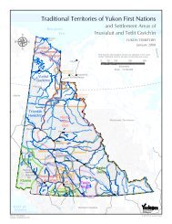
1. Location and Regional Context ..................................................................................................................................... iv<br />
2. Natural <strong>Heritage</strong> Resources ............................................................................................................................................ 8<br />
3. Cultural <strong>Heritage</strong> Resources ........................................................................................................................................... 12<br />
4. Recreation and Tourism Resources ............................................................................................................................... 14<br />
5. Watershed Boundary ....................................................................................................................................................... 20<br />
6. Mineral Occurrences and Mineral Claims ................................................................................................................... 30<br />
7. Trapping/Outfitting Concessions .................................................................................................................................. 44<br />
<strong>Bonnet</strong> <strong>Plume</strong> <strong>Heritage</strong> <strong>River</strong> <strong>Management</strong> <strong>Plan</strong><br />
iiiiii
iivv<br />
Alaska<br />
Yukon <strong>River</strong><br />
Yukon Ri ver<br />
;<br />
;<br />
Yukon Alberta<br />
Yukon <strong>River</strong><br />
Porcupine <strong>River</strong><br />
Dawson City<br />
Stewart <strong>River</strong><br />
Mackenzie <strong>River</strong><br />
Old Crow<br />
British Columbia<br />
Stewart<br />
Crossing<br />
Northwest<br />
Territories<br />
Peel <strong>River</strong><br />
Pelly<br />
Crossing<br />
Mayo<br />
Yukon<br />
Territory<br />
Wind <strong>River</strong><br />
Pelly <strong>River</strong><br />
Watershed Boundary<br />
<strong>Bonnet</strong> <strong>Plume</strong> <strong>River</strong><br />
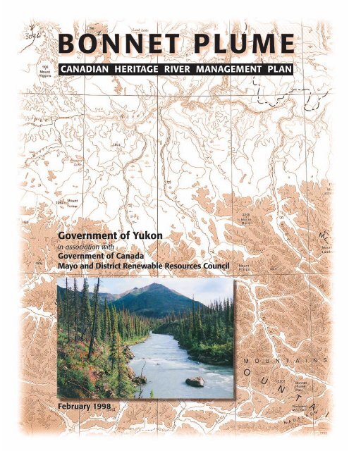
BONNET PLUME RIVER<br />
CANADIAN HERITAGE RIVER<br />
MANAGEMENT PLAN<br />
LOCATION AND<br />
REGIONAL CONTEXT<br />
MAP #1<br />
50 0 50 100 km<br />
Snake <strong>River</strong><br />
Ste wart <strong>River</strong><br />
Mackenzie <strong>River</strong><br />
Northwest<br />
Territories<br />
Arctic Red <strong>River</strong><br />
<strong>Bonnet</strong> <strong>Plume</strong> <strong>Heritage</strong> <strong>River</strong> <strong>Management</strong> <strong>Plan</strong>
BONNET PLUME HERITAGE RIVER MANAGEMENT PLAN<br />
Executive Summary<br />
In January 1993, the entire <strong>Bonnet</strong> <strong>Plume</strong> <strong>River</strong> watershed was nominated to the <strong>Canadian</strong><br />
<strong>Heritage</strong> <strong>River</strong>s System (CHRS) by the Government of Yukon, Indian and Northern Affairs<br />
Canada, and the Mayo District Renewable Resources Council (MDRRC). The MDRRC is the<br />
renewable resources forum established by government and the Nacho Nyak Dun First<br />
Nation within their traditional territory. The nomination fulfills an obligation under the First<br />
Nation of Nacho Nyak Dun (NND) Final Agreement to protect the river’s heritage values.<br />
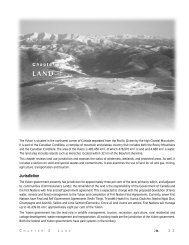
The management plan applies to the entire drainage basin (approximately 12,000 sq. km),<br />
from the headwaters to the junction of the Peel <strong>River</strong> 350 kilometres to the north-west (Maps<br />
1 &2). In addition to meeting the management obligations required by the CHRS nomination,<br />
the NND Final Agreement directs that the management plan shall:<br />
“ establish the boundaries of the river management area and may address all matters relating<br />
to the development, management and use of the <strong>Bonnet</strong> <strong>Plume</strong> <strong>River</strong>, including:<br />
• conservation and management of natural and human heritage resources;<br />
• recreational use;<br />
• water quality and waste management; and<br />
• public information and interpretation.<br />
The preparation of the plan shall include a process for public consultation.” 1<br />
A Steering Committee consisting of two members of the Mayo District Renewable Resources<br />
Council, and one member each from the federal and territorial governments has overseen plan<br />
preparation. A stakeholder Advisory Committee (Appendix 1) was established to provide an<br />
opportunity for direct input into the planning process and advise the Steering Committee.<br />
The management plan respects the provisions of the Nacho Nyak Dun and the overlapping<br />
Tetlit Gwich’in First Nations’ Land Claim Agreement and the principles of the <strong>Canadian</strong><br />
<strong>Heritage</strong> <strong>River</strong>s System.<br />
The plan’s goals and objectives will<br />
be achieved within existing federal<br />
and territorial legislation and their<br />
regulations2 (Appendix 2), as they<br />
apply to settlement and non-settlement<br />
lands. CHRS status itself does<br />
not have legislative powers to<br />
protect the watershed’s resources,<br />
but rather relies on other mechanisms<br />
such as land use planning and<br />
development assessment to determine<br />
land use suitability and the<br />
limits of acceptable change.<br />
Education and voluntary compliance<br />
will be encouraged where<br />
legislation or land claims agreements<br />
do not provide the authority<br />
to regulate.<br />
1 Nacho Nyak Dun Final Agreement, May<br />
29, 1993 p.165<br />
2 For example, the Yukon Waters Act, the<br />
Fisheries Act, the Territorial Lands Act and<br />
Land Use Regulations, the Yukon Quartz<br />
Mining and Placer Mining Acts, and the<br />
territorial Environment and Wildlife Acts<br />
(see 6.2 Appendix 2).<br />
<strong>Bonnet</strong> <strong>Plume</strong> <strong>Heritage</strong> <strong>River</strong> <strong>Management</strong> <strong>Plan</strong><br />
The <strong>Bonnet</strong> <strong>Plume</strong> <strong>River</strong> (YTG)<br />
The <strong>Plan</strong> provides a framework<br />
for future watershed<br />
management and decision<br />
making. It includes a work<br />
program that outlines the roles<br />
and responsibilities, co-<br />
operative working<br />
arrangements, issues,<br />
information gaps, tools and<br />
actions that need to be<br />
considered to manage resource<br />
use effectively.<br />
11
“Stakeholder objectives differ<br />
substantially, ranging from<br />
wilderness preservation and full<br />
area protection to preserving the<br />
opportunity for multiple use<br />
and resource extraction. These<br />
conflicting objectives will be<br />
debated and considered in<br />
various public consultation<br />
processes as provided for in<br />
existing legislation.” –Steering<br />
Committee Member<br />
22<br />
Agency policies, procedures and work program priorities will need to be adjusted to facilitate<br />
inter-agency cooperation and reflect the mutually agreed upon principles and objectives<br />
of this <strong>Heritage</strong> <strong>River</strong> <strong>Management</strong> <strong>Plan</strong>.<br />
The recommendation to include the entire watershed in the management plan and use the<br />
<strong>Canadian</strong> <strong>Heritage</strong> <strong>River</strong>s designation as the mechanism for implementation, reflects two aspirations<br />
of the Nacho Nyak Dun First Nation. The first is to recognise the inheritance value3 of the <strong>Bonnet</strong> <strong>Plume</strong> <strong>River</strong> and watershed, and the First Nation’s desire to use and manage<br />
this legacy in a sustainable manner. The CHRS designation provides the co-operative<br />
management mechanism to achieve the “higher duty of care” desired by First Nations, Canada<br />
and the Yukon government.<br />
The second objective is to ensure the Mayo District Renewable Resources Council plays a<br />
direct role in providing local-level input into subsequent decision making. The MDRRC has<br />
been identified by the Steering Committee as the most appropriate forum for this purpose.<br />
It has the mandate to work with government on renewable resource management issues in<br />
the region and includes a mechanism in its structure to accommodate the trans-boundary land<br />
claim obligations to the Tetlit Gwich’in. Both federal and territorial governments recognise<br />
that a river management partnership requires more local input into decision making and<br />
accept the MDRRC role in a tripartite partnership with respect to <strong>Bonnet</strong> <strong>Plume</strong> watershed<br />
management.<br />
The overall objectives for managing the river from a CHRS nomination perspective are:<br />
1) to conserve the river’s natural and human heritage values;<br />
2) allow for interpretation of these heritage values; and<br />
3) provide recreational and heritage appreciation opportunities.<br />
These CHRS objectives do not preclude a multiple-use environment.<br />
The specific focus of this resource management plan is to meet the management planning<br />
requirements associated with CHRS designation; thus it favours conservation objectives. An<br />
additional factor is the NND rationale for designation, that is, a desire to protect their<br />
“inheritance value”. <strong>Heritage</strong> <strong>River</strong> status is viewed as a means to ensure full local participation<br />
in watershed use and management decision-making.<br />
Similarly, the mining community is not opposed to CHRS status provided it does not create<br />
additional rules which limit their exploration and development rights. Both recognise a “higher<br />
duty of care” 4 approach is implied with this designation.<br />
The presence of significant mineralisation in the heart of the drainage basin has been<br />
confirmed and must be acknowledged. Unless mining exploration and development rules<br />
change, nothing in the management plan limits further mineral exploration or precludes the<br />
possibility of development of potential mining opportunities. However, as explained earlier,<br />
the decision of the parties to the NND Final Agreement to sponsor CHRS designation through<br />
that land claim settlement carries with it an expectation for a “higher duty of care”. Both area<br />
land claims also include a constitutionally entrenched provision regarding protection of water<br />
quality, quantity and rate of flow, that may affect all proposed land use activity within the<br />
<strong>Bonnet</strong> <strong>Plume</strong> watershed. This provision should ensure the primary heritage values for<br />
which the river has been nominated are not compromised over the long term.<br />
There is insufficient information available to prepare a regional land use plan at this point in<br />
time. Thus a priority objective of the management plan is to enhance the quality and<br />
quantity of resource information to facilitate such long range planning. When regional<br />
land use planning for the entire Peel <strong>River</strong> drainage basin is undertaken, the <strong>Heritage</strong> <strong>River</strong><br />
<strong>Management</strong> <strong>Plan</strong> can contribute to this broader, long term objective.<br />
3 “Inheritance value” refers to the perspective and philosophy of First Nations that land has both intrinsic and use<br />
values, and that the responsibility for the care of the land is passed down from each generation.<br />
4 see page 21, section 1.4.2 for a discussion of the meaning of this term.<br />
<strong>Bonnet</strong> <strong>Plume</strong> <strong>Heritage</strong> <strong>River</strong> <strong>Management</strong> <strong>Plan</strong>
The First Nation is not opposed to considering a range of land use activities within the watershed,<br />
nor do they wish to preclude any specific development opportunities in the <strong>Bonnet</strong><br />
<strong>Plume</strong> watershed at this time. Should a proposal threaten the integrity of their inheritance,<br />
the Nacho Nyak Dun caution that they are quite prepared to recommend to government that<br />
a specific project not proceed.<br />
This management plan explains the natural and cultural heritage values of the watershed which<br />
must be protected to meet CHRS standards. It defines both the knowledge required to<br />
improve decision making as well as the circumstances which should trigger management intervention<br />
to ensure CHRS objectives are sustained. It includes a specific work program identifying<br />
what actions are required, by whom, and when, to meet plan objectives.<br />
<strong>Management</strong> objectives for natural heritage resources include identification and protection<br />
of: fish habitat; rare and endangered species/special features; vegetation; water quality; wilderness;<br />
and wildlife resources. Additional baseline studies are recommended for all of these<br />
resources since current information is incomplete for comprehensive integrated resource planning<br />
and long term management purposes. The available data is sufficient however, to support<br />
the river’s nomination to the CHR system in the Yukon context.<br />
The Nacho Nyak Dun and Tetlit Gwich’in First Nations have a long-standing history of use of<br />
the <strong>Bonnet</strong> <strong>Plume</strong> watershed. The plan calls for these rich cultural heritage resources to be<br />
documented, protected and respected in management decision making. The plan recognises<br />
the inheritance values of the <strong>Bonnet</strong> <strong>Plume</strong> watershed and supports the continuation of traditional<br />
uses.<br />
The plan acknowledges the outstanding water and land-based recreation and tourism<br />
resources of the <strong>Bonnet</strong> <strong>Plume</strong> watershed. Visitors can discover and experience a distinctive<br />
Yukon ecoregion and wilderness river. Wildlife populations have supported a long history of<br />
hunting and trapping activity. Rafting, canoeing, hiking and wildlife viewing opportunities also<br />
abound.<br />
Wernecke Mountains (B. Downie)<br />
<strong>Bonnet</strong> <strong>Plume</strong> <strong>Heritage</strong> <strong>River</strong> <strong>Management</strong> <strong>Plan</strong><br />
The management plan provides<br />
a framework for co-ordination<br />
and co-operative action.<br />
33
“That <strong>Bonnet</strong> <strong>Plume</strong>, that’s<br />
clean water. Pure. Good fishing<br />
there.”<br />
–Sam Peter<br />
<strong>Bonnet</strong> <strong>Plume</strong> Lake (B. Downie)<br />
44<br />
The objective is to provide visitors with high quality opportunities for wildland recreation in<br />
a sustainable manner. The benefits of such tourism and recreation activity should accrue as<br />
much as possible to regional residents.<br />
Eleven main management issues are discussed ranging from the promotion of biodiversity and<br />
protection of wilderness values to the adequacy of current resource information.<br />
Any economic development must be managed to conserve values basic to the <strong>Canadian</strong><br />
<strong>Heritage</strong> <strong>River</strong> designation. Economic activities need to be compatible with resource objectives,<br />
with environmental impacts minimised. The <strong>Bonnet</strong> <strong>Plume</strong> watershed contains a<br />
number of existing and potential economic development opportunities which have implications<br />
for watershed planning and development. The settlement of land claims also establishes<br />
economic development obligations which need to be considered in planning and<br />
management. Such land claim settlement obligations require a different management<br />
regime than would be found in southern Canada. Economic values include the inherent value<br />
of wildlands as well as the development opportunities associated with adventure travel, outfitting<br />
and minimal resource extraction.<br />
The management plan suggests research is<br />
needed to define the limits of acceptable change<br />
in terms which can be measured against baseline<br />
conditions.<br />
This management plan includes a 5-year workplan<br />
which identifies work priorities, agency responsibilities,<br />
key steps to be taken and anticipated<br />
outcomes. As the initial management plan, it<br />
focuses on resolving information gaps and building<br />
a cooperative management regime for the<br />
watershed as a whole.<br />
<strong>Bonnet</strong> <strong>Plume</strong> <strong>Heritage</strong> <strong>River</strong> <strong>Management</strong> <strong>Plan</strong>
1.0 INTRODUCTION AND BACKGROUND<br />
1.1 Purpose of <strong>Canadian</strong> <strong>Heritage</strong> <strong>River</strong>s System<br />
The <strong>Canadian</strong> <strong>Heritage</strong> <strong>River</strong>s System (CHRS) is a co-operative program, established in 1984,<br />
to give national recognition to rivers which have outstanding natural and human heritage<br />
values, and provide significant recreational opportunities. The program objectives include:<br />
• raising public awareness of a river’s heritage values,<br />
• seeking recognition of the need for integrated resource management to preserve<br />
such values, and<br />
• ensuring a river management plan is prepared to that end.<br />
The CHRS program is administered by federal, provincial and territorial governments in association<br />
with First Nations, local communities, and interest groups. Federal, provincial, territorial<br />
and First Nation governments which participate in the establishment and administration of<br />
a <strong>Canadian</strong> <strong>Heritage</strong> <strong>River</strong> retain their traditional jurisdictional powers. This includes ownership<br />
of the land, the choice to nominate a river to the system, and the right to continue to<br />
operate and manage designated rivers in accordance with the objectives of the system.<br />
1.2 First Nation Land Claim Settlement Obligations<br />
The Nacho Nyak Dun and Tetlit Gwich’in First Nations land claim agreements have been finalised.<br />
Both First Nations have land selections and management rights within the <strong>Bonnet</strong> <strong>Plume</strong><br />
watershed (Map 3). The following provides an introduction to the agreements and highlights<br />
the sections applicable to CHRS designation. Various committees and boards are to be<br />
formed as a result of these agreements. They can all contribute to the management of the <strong>Bonnet</strong><br />
<strong>Plume</strong> watershed’s natural and cultural resources, and influence its use and development.<br />
1.2.1 Nacho Nyak Dun First Nation<br />
In May, 1993, the Government of Canada together with the Government of Yukon and the<br />
First Nation of NND signed the First Nation of Nacho Nyak Dun Final Agreement<br />
(FNNNDFA), including an implementation plan. This constitutionally protected agreement<br />
became effective February 14, 1995.<br />
Chapter 13, Schedule B, Sections 2.1-2.3 of the FNNNDFA states that:<br />
• Government shall submit to the Board (CHRS) a nomination document for the<br />
<strong>Bonnet</strong> <strong>Plume</strong> <strong>River</strong> before January 31, 1993, or as soon as practical thereafter.<br />
• Government, after consultation with the Mayo District Renewable Resources<br />
Council, shall prepare the nomination document in accordance with the <strong>Canadian</strong><br />
<strong>Heritage</strong> <strong>River</strong>s System program.<br />
• The Board (CHRSB) shall consider the nomination; and make a recommendation to<br />
the Ministers, in accordance with the provisions of the <strong>Canadian</strong> <strong>Heritage</strong> <strong>River</strong>s<br />
System program.<br />
Schedule B outlines the planning process to be followed. It provides direction concerning the<br />
establishment and makeup of a Steering Committee to oversee preparation of the management<br />
plan, and includes guidelines concerning the content, boundaries and approach to be<br />
used in preparation and review. Schedule B of the FNNNDFA is presented in Appendix 3.<br />
The NNDFA designates the Mayo District Renewable Resources Council as the primary forum<br />
for making recommendations to the appropriate body on matters relating to conservation of<br />
fish and wildlife within NND traditional territory. Its primary focus is on fish and wildlife<br />
management. The Council comprises 6 members: three nominated by the Nacho Nyak Dun<br />
First Nation and three nominated by the Yukon Minister of Renewable Resources. The<br />
Council comprises half of the members of the <strong>Bonnet</strong> <strong>Plume</strong> Steering Committee (as<br />
required in the Nacho Nyak Dun Final Agreement). The Steering Committee has reviewed<br />
this management plan and supports presenting it to the Ministers for approval.<br />
<strong>Bonnet</strong> <strong>Plume</strong> <strong>Heritage</strong> <strong>River</strong> <strong>Management</strong> <strong>Plan</strong><br />
55
The <strong>Bonnet</strong> <strong>Plume</strong> <strong>River</strong> was<br />
one of seven Yukon rivers<br />
recommended as potential<br />
CHRS candidates<br />
(Juurand and Associates, 1987)<br />
66<br />
It should be noted that when the Council is exercising powers and responsibilities within the<br />
Tetlit Gwich’in Primary Use Area in the Yukon, the three members nominated by the<br />
Nacho Nyak Dun First Nation are replaced by three members representing the Tetlit<br />
Gwich’in.<br />
The FNNNDFA also provides an opportunity for future establishment of a Regional Land Use<br />
<strong>Plan</strong>ning Commission to oversee preparation of a regional land use plan.<br />
1.2.2 Tetlit Gwich’in First Nation<br />
The Gwich’in Comprehensive Land Claim Agreement was signed April 22, 1992, by the<br />
Gwich’in Tribal Council, the Government of Canada, and the Government of the Northwest<br />
Territories. This Agreement became effective in December 1992. The settlement legislation<br />
includes certain trans-boundary rights in the Yukon. Within their traditional territory, the Tetlit<br />
Gwich’in have title to 1,544 sq. km (approximately 600 square miles) of land in the Yukon.<br />
Some of their titled land is within the <strong>Bonnet</strong> <strong>Plume</strong> watershed (see Appendix 4 for legal<br />
description).<br />
The Gwich’in Comprehensive Land Claim Agreement calls for the creation of a number of<br />
management boards. Of interest to heritage river management was the creation of the Peel<br />
<strong>River</strong> Watershed Advisory Committee in 1994 with a two year term. This Committee was<br />
mandated to:<br />
• consider and make recommendations respecting the establishment of a water<br />
management agreement for the Peel <strong>River</strong> watershed,<br />
• consider and make recommendations respecting the establishment of a regional<br />
land-use planning commission (or similar agency )for any area which includes the<br />
Peel <strong>River</strong> watershed; and<br />
• consider and make recommendations regarding the need for, and establishment of<br />
Special <strong>Management</strong> Areas in the Peel <strong>River</strong> watershed.<br />
This Committee included three representatives from the Nacho Nyak Dun First Nation, three<br />
from the Tetlit Gwich’in, and two each from the governments of Canada, Yukon and the<br />
Northwest Territories. The Committee completed it’s mandate in March 1996. The<br />
Committee concluded more additional baseline watershed research was needed for planning<br />
and development assessment purposes. This management plan responds to that direction.<br />
1.3 <strong>Bonnet</strong> <strong>Plume</strong> <strong>Heritage</strong> <strong>River</strong> Nomination<br />
1.3.1 History of the CHRS Program in the Yukon<br />
The Government of Yukon, Department of Renewable Resources, has been a participant in<br />
the CHRS program since its inception in 1984. A systems framework study was initiated in<br />
1987 (Juurand and Associates 1987) with a CHRS System <strong>Plan</strong> completed in 1988 (PRP Parks:<br />
Research & <strong>Plan</strong>ning Inc.) This system study reviewed a total of 77 Yukon rivers, assessing their<br />
natural and cultural heritage resources and recreational potential. In the final stage of study,<br />
other factors including geographic region representation, theme representation, river<br />
morphology, navigability and land-use compatibility were used to determine final river<br />
rankings. The <strong>Bonnet</strong> <strong>Plume</strong> <strong>River</strong> ranked among the top candidates for CHRS status.<br />
1.3.2 <strong>Bonnet</strong> <strong>Plume</strong> <strong>Plan</strong>ning Process<br />
The <strong>Bonnet</strong> <strong>Plume</strong> <strong>River</strong> drainage was identified as an important area deserving special management<br />
during the negotiations of the Nacho Nyak Dun Final Agreement. The negotiators<br />
agreed CHRS designation might be the appropriate management designation to meet this<br />
objective. Government agreed to submit a nomination. Once the nomination was accepted,<br />
a ‘Steering Committee’ was established with members from the Mayo District Renewable<br />
Resources Council, Yukon Parks, Parks Canada and DIAND. A background study was commissioned<br />
(PRP Parks: Research & <strong>Plan</strong>ning Inc. 1992a) which confirmed the <strong>Bonnet</strong> <strong>Plume</strong><br />
<strong>River</strong> could meet the CHRS nomination criteria. The consultants also indicated there were significant<br />
data gaps which could impede subsequent management planning.<br />
<strong>Bonnet</strong> <strong>Plume</strong> <strong>Heritage</strong> <strong>River</strong> <strong>Management</strong> <strong>Plan</strong>
Available information concerning the <strong>Bonnet</strong> <strong>Plume</strong> <strong>River</strong> was reviewed. Knowledgeable individuals,<br />
including outfitters, hunters, trappers and mining geologists, with personal experience<br />
in the area were contacted. Preliminary consultation meetings were held in Mayo with the<br />
Nacho Nyak Dun First Nation and with other community members. Members of the Tetlit<br />
Gwich’in First Nation in Fort McPherson were also consulted during preparation of the nomination<br />
report. Industry expressed concern that as stakeholders, they were not adequately<br />
consulted during the initial stages of the nomination process. The Steering Committee<br />
agreed to respond to this concern.<br />
A formal nomination document was subsequently prepared and signed by the Yukon<br />
Minister of Renewable Resources, Chair of the Mayo District Renewable Resources Council<br />
and the Minister of Indian Affairs and Northern Development.<br />
The CHRS Board approved the nomination in January, 1993. The approval required completion<br />
of a management plan within three years. An extension was granted in the fall of 1995.<br />
A Steering Committee consisting of two members of the Mayo District Renewable Resource<br />
Council, and one member from each of the federal and territorial governments (DIAND Water<br />
Resources and Renewable Resources, Parks & Outdoor Recreation Branch) were assigned<br />
to oversee plan preparation.<br />
The Steering Committee hired Trans Northern Ltd. to design a ‘Consultation Process’ for stakeholders<br />
interested in participating in the preparation of a management plan for the <strong>Bonnet</strong><br />
<strong>Plume</strong> watershed. The consultation process was designed to provide opportunities to<br />
review background materials, submit new information and identify issues. In addition, it was<br />
mandated to generate recommendations for river management including refining the ultimate<br />
boundaries for the CHRS designation.<br />
A stakeholder Advisory Committee was also formed in March 1994 to give advice to the<br />
Steering Committee and provide an opportunity for direct input into the planning process.<br />
Representation was invited from the following organisations: First Nation of Nacho Nyak Dun,<br />
Tetlit Gwich’in, <strong>Canadian</strong> Parks and Wilderness Society, Friends of Yukon <strong>River</strong>s, Yukon<br />
Chamber of Mines, Klondike Placer Miners Association, Westmin Resources Limited,<br />
Pamicon Developments Limited, Widrig Outfitters Ltd., <strong>Bonnet</strong> <strong>Plume</strong> Outfitters, Yukon<br />
Wilderness Tourism Association, Yukon Conservation Society, the Yukon Trapper’s<br />
Association, and the villages of Mayo and Elsa/Keno.<br />
The objective of the ‘Advisory Committee’ was to identify management objectives that<br />
reflected the interests of all stakeholders while protecting CHRS values in the <strong>Bonnet</strong><br />
<strong>Plume</strong> <strong>River</strong>. <strong>Management</strong> objectives for ten different resources were discussed by the<br />
‘Advisory Committee’ during four meetings held from March to October, 1994. The<br />
‘Steering Committee’ used this input to prepare a draft ‘<strong>Management</strong> <strong>Plan</strong>’.<br />
The draft management plan was prepared by Yukon government staff and circulated to stakeholders<br />
for review and comment. It was hoped that this process would lead to stakeholder<br />
consensus but this was not the case. In particular, conservation and mining interests<br />
remained polarised. This was reflected in the comments received on the draft document.<br />
The Steering Committee considered the comments received and, on the advice of the<br />
Advisory Committee, hired an independent consultant to prepare a second draft. The consultant<br />
was directed to incorporate the comments and reflect the role of First Nations and the<br />
MDRRC in plan development and implementation. The revised document was not to be a land<br />
use plan. It was to focus on identifying the specific actions needed and partnerships required<br />
to meet the objectives for which the <strong>Bonnet</strong> <strong>Plume</strong> <strong>River</strong> was nominated. The Steering<br />
Committee wanted the final management plan to include a 3-5 year work program. This would<br />
identify what needed to be done and by whom, explain how data gaps would be resolved,<br />
and how MDRRC and First Nation input into resource management decisions would occur.<br />
Before being presented to the CHRS Board, the final <strong>Bonnet</strong> <strong>Plume</strong> <strong>Heritage</strong> <strong>River</strong><br />
<strong>Management</strong> <strong>Plan</strong> must be signed off by the Mayo District Renewable Resources Council and<br />
approved by the Federal Minister for Indian and Northern Affairs, and the Territorial Minister<br />
for Renewable Resources.<br />
<strong>Bonnet</strong> <strong>Plume</strong> <strong>Heritage</strong> <strong>River</strong> <strong>Management</strong> <strong>Plan</strong><br />
77
Peel <strong>River</strong><br />
BONNET PLUME RIVER<br />
CANADIAN HERITAGE RIVER<br />
MANAGEMENT PLAN<br />
132˚<br />
133˚<br />
134˚<br />
s<br />
88<br />
s<br />
Noisy<br />
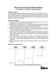
NATURAL HERITAGE<br />
RESOURCES<br />
MAP #2<br />
NORTHWEST TERRITORIES<br />
YUKON TERRITORY<br />
s<br />
Basin Creek<br />
LEGEND<br />
Physiographic feature<br />
Creek<br />
Mineral lick<br />
Occasional southernmost boundary of<br />
Porcupine Caribou Herd winter range<br />
BONNET<br />
s<br />
w sp*<br />
WILDLIFE SPECIES SEASONAL USE<br />
Knorr Creek<br />
w sp*<br />
Margaret<br />
Lake<br />
s<br />
Waterfowl w winter (Oct. - Apr.)<br />
s<br />
Caribou s summer (June - Aug.)<br />
Rapitan Creek<br />
w sp*<br />
w sp*<br />
Sheep sp spring (Apr. - June)<br />
s<br />
Quartet<br />
Lakes<br />
Grizzly Bear f fall (Aug. - Oct.)<br />
Phelps Mountain<br />
Gyrfalcon &/or y yearround<br />
Golden Eagle<br />
Fairchild<br />
Lake<br />
PLUME<br />
Slats Cr ek<br />
65˚<br />
Peregrine Falcon<br />
&/or Osprey<br />
&/or Bald Eagle<br />
Limestone<br />
Caves<br />
w*<br />
EXAMPLE<br />
wildlife species<br />
key habitat area boundary<br />
anecdotal information only<br />
MacDonald<br />
Mountain<br />
Pinguicula<br />
Cr.<br />
Gillespie<br />
Lake<br />
w*<br />
w sp*<br />
seasonal use<br />
N<br />
w*<br />
Goz<br />
Lake<br />
Creek<br />
Corn<br />
Gillespie Creek<br />
Duo<br />
Lake<br />
Massive<br />
Landslide<br />
Canyon<br />
s<br />
y*<br />
sp*<br />
Falls & Rapids<br />
Goz Creek<br />
RIVER<br />
Rubble Cr.<br />
Duo Creek<br />
f w*<br />
Kohse Creek<br />
<strong>Bonnet</strong><br />
<strong>Plume</strong><br />
Lake<br />
Watershed<br />
Area<br />
Falls & Rapids<br />
0 5 10 15 20km<br />
131˚<br />
132˚<br />
134˚ 133˚<br />
135˚<br />
<strong>Bonnet</strong> <strong>Plume</strong> <strong>Heritage</strong> <strong>River</strong> <strong>Management</strong> <strong>Plan</strong>
1.3.3 CHRS <strong>Management</strong> <strong>Plan</strong> Requirements<br />
To qualify for inclusion in the <strong>Canadian</strong> <strong>Heritage</strong> <strong>River</strong>s System, a river, or section of river, must<br />
have features of outstanding <strong>Canadian</strong> significance in one or more of the following areas:<br />
natural heritage, cultural heritage, recreation and tourism, or general integrity values. The nominated<br />
section should be large enough to encompass these values, safeguard their integrity,<br />
and provide the user with an appreciation of the river’s resources, as well as an enjoyable<br />
recreational experience. Each of the four CHRS selection guidelines (1990) are presently met<br />
by the <strong>Bonnet</strong> <strong>Plume</strong> <strong>River</strong> and its drainage basin. The following sections summarise the<br />
<strong>Bonnet</strong> <strong>Plume</strong> watershed’s heritage, use and natural integrity values, which formed the basis<br />
for its CHRS nomination. (For more detail, refer to the Background Study and Nomination<br />
document).<br />
1.3.3.1 Natural <strong>Heritage</strong> Values<br />
The natural heritage values of the <strong>Bonnet</strong> <strong>Plume</strong> <strong>River</strong> are the primary reason for its nomination<br />
to the CHRS (PRP Parks 1992b). The <strong>Bonnet</strong> <strong>Plume</strong> watershed possesses a wide variety<br />
of natural characteristics that are both representative of the regional landscape evolution and<br />
significant in terms of their uniqueness, quality or abundance (Map 2).<br />
Several outstanding features of the area reflect an evolutionary history extending back to the<br />
late Precambrian period. Complex and repeated tectonic events have created a unique, composite<br />
physiographic and structural depression in the northern <strong>Canadian</strong> Cordillera. This depression<br />
(also known as the <strong>Bonnet</strong> <strong>Plume</strong> Basin) covers an area of approximately 322 square kilometres<br />
and forms the lower (northern) portion of the watershed. The Basin is underlain by<br />
Tertiary aged sedimentary rocks containing lignite coals in the north, and by Cretaceous aged<br />
sedimentary rocks containing bituminous coals in the south. The thickest and most extensive<br />
coal deposits in the Yukon extend from the Wind <strong>River</strong> through the <strong>Bonnet</strong> <strong>Plume</strong> watershed<br />
towards the confluence of the Peel. Duck-billed dinosaur remains have also been discovered<br />
in the Basin in the vicinity of the <strong>Bonnet</strong> <strong>Plume</strong>-Peel <strong>River</strong> confluence.<br />
Upper <strong>Bonnet</strong> <strong>Plume</strong> <strong>River</strong> (B. Downie)<br />
<strong>Bonnet</strong> <strong>Plume</strong> <strong>Heritage</strong> <strong>River</strong> <strong>Management</strong> <strong>Plan</strong><br />
Natural <strong>Heritage</strong> Guideline:<br />
The river is an outstanding<br />
example of a river environment<br />
affected by the major stages and<br />
processes in the earth’s<br />
evolutionary history present in<br />
Canada. This would include<br />
rivers which best represent the<br />
major periods of geological time<br />
in which the surface of the earth<br />
underwent major changes and<br />
stream modification.<br />
–CHRS Nomination Guidelines<br />
99
Natural <strong>Heritage</strong> Guideline:<br />
The river is an outstanding<br />
representation of significant<br />
ongoing fluvial,<br />
geomorphological and biological<br />
processes. As distinct from the<br />
periods of the earth’s<br />
development, this focuses upon<br />
ongoing processes in the<br />
evolution and form of the river<br />
and its associated plant and<br />
animal communities;<br />
–CHRS Nomination Guidelines<br />
Massive slide below <strong>Bonnet</strong> <strong>Plume</strong> Lake (B. Downie)<br />
1100<br />
The Basin contrasts sharply with the upper (southern) sections of the watershed. The latter<br />
consists of uplifted metamorphic and sedimentary rock structures where three mountain<br />
systems, the Werneckes, Richardsons and Mackenzies meet. Glacial landforms such as<br />
arêtes, cirques and moraines are evidence of Laurentide glaciation in the area. A proliferation<br />
of rock glaciers occur in the watershed’s many valleys and low-lying areas and extend to midslope<br />
levels.<br />
Like the evolutionary history evident in the river valley, the on-going processes of landscape<br />
development, such as glacial, fluvial and biological processes, may also be observed in the<br />
<strong>Bonnet</strong> <strong>Plume</strong> watershed. Scree slopes, avalanche paths, braided gravel bars, hoodoos, and<br />
stream deltas are examples of the geomorphological processes present. One of the most<br />
outstanding geomorphic features is the massive landslide feature in the upper reaches of the<br />
river through which the river has carved a major canyon.<br />
More recently, large scale mass wasting is evident in the ice rich soils of the <strong>Bonnet</strong> <strong>Plume</strong><br />
Basin near the confluence of the Peel <strong>River</strong>. The area also has an active fire history which<br />
affects ground stability, vegetation succession and wildlife distribution.<br />
Outstanding and even rare examples of a number of different landscape features are found in<br />
the <strong>Bonnet</strong> <strong>Plume</strong> <strong>River</strong> system. These include the previously mentioned unusually large<br />
landslide site just north of <strong>Bonnet</strong> <strong>Plume</strong> Lake, as well as evidence of mass wasting and alpine<br />
glaciation, complex regional geology, and river morphology. The natural beauty of the main<br />
valley and many of the upper reaches of the tributary areas are specifically noteworthy. The mountain<br />
peaks, ridges, canyons, incised valleys and small lake settings such as <strong>Bonnet</strong> <strong>Plume</strong>,<br />
Margaret, and the Quartet Lakes create an attractive and visually appealing wilderness landscape.<br />
Portions of the watershed remained unglaciated during the last ice age as part of the<br />
Beringia refugium. Because much of the rest of the Yukon was glaciated during that time, the<br />
areas not affected by glaciation contain different landform and vegetation characteristics.<br />
<strong>Bonnet</strong> <strong>Plume</strong> <strong>Heritage</strong> <strong>River</strong> <strong>Management</strong> <strong>Plan</strong>
The <strong>Bonnet</strong> <strong>Plume</strong> <strong>River</strong> system appears to be significant for its biological abundance and<br />
diversity, and for rare and unique concentrations of plants and animals. Noteworthy is the presence<br />
of the large, sedentary, <strong>Bonnet</strong> <strong>Plume</strong> woodland caribou herd, and the concentrations<br />
of grizzly bear. Four rare vascular plants, Papaver walpolei (Argus and Pryer 1990), Erigeron<br />
hyssopifolius, Cypripedium calceolus ssp. parviflorum and Potentilla pensylvanica (considered<br />
rare north of 64°(N) (Douglas et al, 1981) have been identified in the watershed to date<br />
(Kennedy Pers. comm.). Range extending occurrences have also been noted. These include<br />
a species of saxifrage, Boykinia richardsonii, near its eastern limit, Oxytropis campestris ssp.<br />
jordalii near its southern limit and Carex filifolia, Senecio scheldonensis, Goodyera repens and<br />
Actaea rubra all at the northern limit of their range. As more detailed vegetation studies are<br />
completed, especially in the un-glaciated portions of the watershed, more range extensions<br />
and rare plant occurrences are expected to be discovered.<br />
There are also a number of lakes, in the portion of the watershed which remained unglaciated<br />
as part of the Beringia refugium, which contain unique, relict fish populations. An example<br />
of this is a lake whitefish stock now confined to Margaret Lake.<br />
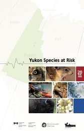
1.3.3.2 Cultural <strong>Heritage</strong> Values<br />
The cultural heritage values of the <strong>Bonnet</strong> <strong>Plume</strong> area are an integral part of the rationale<br />
behind the nomination of the <strong>Bonnet</strong> <strong>Plume</strong> <strong>River</strong> to the <strong>Canadian</strong> <strong>Heritage</strong> <strong>River</strong>s System.<br />
The <strong>Bonnet</strong> <strong>Plume</strong> watershed has been described by Nacho Nyak Dun and Tetlit Gwich’in<br />
elders as part of their inheritance; akin to a priceless, cultural and economic bank (Map 3).<br />
The CHRS selection guidelines for human heritage values reflect a non-First Nations perspective<br />
of history and human occupation. Values recognised by First Nations are not necessarily<br />
coincident with these categories. For example, ‘First Nations people’ is listed with ‘settlement<br />
patterns’ and ‘transportation’. In reality, the category of First Nations people, introduces a<br />
much broader range of potential themes and encompasses First Nations settlement and transportation.<br />
In addition, the criteria which emphasise ‘persons’, ‘events’ and ‘achievements’ as<br />
well as ‘historical or archaeological structures’ reflect a more typical Euro-american approach<br />
to history.<br />
Massive slump near the confluence of the Peel <strong>River</strong> (B. Slater)<br />
<strong>Bonnet</strong> <strong>Plume</strong> <strong>Heritage</strong> <strong>River</strong> <strong>Management</strong> <strong>Plan</strong><br />
Natural <strong>Heritage</strong> Guideline:<br />
The river contains along its<br />
course unique, rare or<br />
outstanding examples of natural<br />
phenomena, formations or<br />
features, or areas of exceptional<br />
natural beauty.<br />
–CHRS Nomination Guidelines<br />
Natural <strong>Heritage</strong> Guideline:<br />
The river contains along its<br />
course, habitats of rare or<br />
endangered species of plants and<br />
animals. This would also<br />
include areas where outstanding<br />
concentrations of plants and<br />
animals of <strong>Canadian</strong> interest<br />
and significance are found.<br />
–CHRS Nomination Guidelines<br />
Each of the four CHRS<br />
guidelines pertaining to natural<br />
heritage are met by the <strong>Bonnet</strong><br />
<strong>Plume</strong> watershed.<br />
1111
Peel <strong>River</strong><br />
BONNET PLUME RIVER<br />
CANADIAN HERITAGE RIVER<br />
MANAGEMENT PLAN<br />
132˚<br />
133˚<br />
134˚<br />
2<br />
1<br />
1122<br />
3<br />
Noisy<br />
CULTURAL HERITAGE<br />
RESOURCES<br />
4 5<br />
6<br />
Chappie<br />
Lake<br />
HT<br />
MAP #3<br />
NORTHWEST TERRITORIES<br />
Basin Creek<br />
LEGEND<br />
HISTORICAL LAND USES<br />
Creek<br />
Historic trail<br />
YUKON TERRITORY<br />
Lower Boundary of<br />
Tetlit Gwich'in Primary Use Area<br />
BONNET<br />
65˚ 30'<br />
Old Camps<br />
8<br />
Traditional travel route<br />
General areas for traditional winter hunting<br />
and trapping<br />
HT<br />
Margaret<br />
Lake<br />
Knorr Creek<br />
Key First Nation use area (sites selected<br />
under Nacho Nyak Dun Final Agreement)<br />
HT<br />
7<br />
Key First Nation use area (Rural Land<br />
selected under the Tetlit Gwich'in Final<br />
Agreement)<br />
Rapitan Creek<br />
Snake <strong>River</strong><br />
to headwaters<br />
Quartet<br />
Lakes<br />
HISTORICAL LAND USES<br />
1. Khatainlaii ehdi' (Stand of timber<br />
where–water–flows–out)<br />
2. Chuu tridaodiich'uu (Rough hateful water)<br />
Phelps Mountain<br />
Fairchild<br />
Lake<br />
PLUME<br />
HT<br />
HT<br />
Slats Cr ek<br />
65˚<br />
3. Ezhinakan (Burning Hill)<br />
4. Tsaih tl'ak njik (Black Sands creek– name for<br />
<strong>Bonnet</strong> <strong>Plume</strong> <strong>River</strong>)<br />
5. Zhi'dahnyuu njik (Waterfowl–making–noise creek)<br />
to Wind <strong>River</strong><br />
6. Guk'an'choo (Big burning place)<br />
7. Sadar vahan (Sadar her–river)<br />
8. Tsaih tl'ak ddhaa' (Black Sands mountain)<br />
MacDonald<br />
Mountain<br />
Pinguicula<br />
Cr.<br />
Gillespie<br />
Lake<br />
N<br />
Goz<br />
Lake<br />
Creek<br />
Corn<br />
Gillespie Creek<br />
Duo<br />
Lake<br />
HT<br />
Goz Creek<br />
RIVER<br />
Rubble Cr.<br />
Duo Creek<br />
Kohse Creek<br />
<strong>Bonnet</strong><br />
<strong>Plume</strong><br />
Lake<br />
<strong>Bonnet</strong> <strong>Plume</strong> Pass<br />
Watershed<br />
Area<br />
to Rachla <strong>River</strong><br />
0 5 10 15 20km<br />
131˚<br />
132˚<br />
134˚ 133˚<br />
135˚<br />
<strong>Bonnet</strong> <strong>Plume</strong> <strong>Heritage</strong> <strong>River</strong> <strong>Management</strong> <strong>Plan</strong>
The human heritage resource values are deeply rooted in the Tetlit Gwich’in and Nacho Nyak<br />
Dun people. The watershed functioned as their larder, travel and trade corridor and seasonal<br />
home. The ancestors of the Tetlit Gwich’in and Nacho Nyak Dun followed subsistence<br />
lifestyles in the <strong>Bonnet</strong> <strong>Plume</strong> area for centuries. The migratory movement of caribou<br />
across the upper Peel <strong>River</strong> basin made the <strong>Bonnet</strong> <strong>Plume</strong> drainage an important winter<br />
hunting area. The region was also used for travel, meetings, and inter-tribal trade. Other First<br />
Nation cultural groups, “Klondikers”, trappers and prospectors have also traversed and<br />
occupied portions of the valley. Prospectors such as Count V.E. de Sainville explored the<br />
region in 1893 followed by government geologist Charles Camsell in 1906.<br />
Today the area continues to draw together the people of Mayo, Yukon, and Fort McPherson,<br />
NWT who share a common historical bond. Their special places include traditional subsistence<br />
areas, camps, grave sites, and sites of spiritual renewal. All are important features of the<br />
area.<br />
Because of the scarcity of documented information, only one of the four CHRS human<br />
heritage selection guidelines, the one relating to ‘<strong>Canadian</strong> historical development in terms<br />
of first nations people, settlement patterns, and transportation’, can be met without further<br />
study5 .<br />
The other three criteria relating to persons, events, movements, achievements, ideas or beliefs,<br />
unique historical/archaeological structures, and outstanding or concentrated historical/archaeological<br />
structures, are only partially met in light of presently available information. The<br />
Gwich’in Social and Cultural Institute formed in 1992 recently completed a traditional use<br />
and knowledge study of the Arctic Red <strong>River</strong> as part of that <strong>Heritage</strong> <strong>River</strong> <strong>Management</strong> <strong>Plan</strong>.<br />
Similar work is anticipated involving the rest of the Peel <strong>River</strong> watershed within Tetlit<br />
Gwich’in traditional territory and this will encompass a portion of the lower <strong>Bonnet</strong> <strong>Plume</strong><br />
watershed.<br />
On January 30, 1996, the Yukon government signed a Statement of Commitment binding it<br />
to the <strong>Canadian</strong> Biodiversity Strategy and to the protection and maintenance of biodiversity.<br />
This belief in the importance of preserving biodiversity and recognising the intrinsic value of<br />
wild places is an integral part of the rationale behind seeking CHRS designation for the entire<br />
<strong>Bonnet</strong> <strong>Plume</strong> watershed. The idea that wilderness has value in its own right and the belief<br />
in the importance of biodiversity reflect this national conservation perspective. The Nacho<br />
Nyak Dun and Tetlit Gwich’in First Nations hold similar views. They describe it in different<br />
terms such as “inheritance value” or respect for “the land”. From both of these perspectives,<br />
it can be argued that the <strong>Bonnet</strong> <strong>Plume</strong> watershed has inherent wilderness value consistent<br />
with the Human <strong>Heritage</strong> Guidelines provision concerning “ideas and beliefs”.<br />
1.3.3.3 Recreation <strong>Heritage</strong> Values<br />
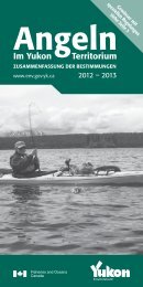
The recreational values of the <strong>Bonnet</strong> <strong>Plume</strong> <strong>River</strong> watershed are exceptional. A wide<br />
variety of river oriented and upland recreational opportunities exist, including: kayaking,<br />
canoeing, camping, hiking, mountain climbing, hunting and fishing as well as nature study,<br />
wildlife viewing, photography, and human heritage appreciation (Map 4). Natural values<br />
include the diversity and quality of scenic views, and the character of the river itself such as<br />
the flow, navigability, quantity and quality of rapids, accessibility and shoreline conditions.<br />
A key attribute of the area is its remoteness which limits the number of recreational users. The<br />
quality of wilderness experience afforded by the <strong>Bonnet</strong> <strong>Plume</strong> area attracts an international<br />
clientele.<br />
Campsites along the river are plentiful. In the middle and upper reaches of the river, access<br />
to the highlands above the river valley is often easy and inviting. Hiking routes within the<br />
watershed can vary from an evening exploration up a small side creek, to major trips into the<br />
upper reaches of the drainage basin.<br />
5 <strong>Bonnet</strong> <strong>Plume</strong> <strong>River</strong>: CHRS Nomination Document p. 8<br />
<strong>Bonnet</strong> <strong>Plume</strong> <strong>Heritage</strong> <strong>River</strong> <strong>Management</strong> <strong>Plan</strong><br />
Cultural <strong>Heritage</strong> Guidelines:<br />
The CHRS guidelines indicate<br />
that outstanding human<br />
heritage value will be recognised<br />
when a river environment:<br />
• has influenced, over a period of<br />
time, the historical<br />
development of Canada<br />
through a major impact upon<br />
the region in which it is<br />
located or beyond; (this would<br />
include its role in such<br />
significant historical themes as<br />
first nations people, settlement<br />
patterns and transportation);<br />
• is strongly associated with<br />
persons, events, movements,<br />
achievements, ideas or beliefs<br />
of <strong>Canadian</strong> significance;<br />
• contains historical or<br />
archaeological structures,<br />
works or sites which are<br />
unique, rare or of great<br />
antiquity; and/or<br />
• contains outstanding examples<br />
or concentrations of historical<br />
or archaeological structures,<br />
works or sites which are<br />
representative of major themes<br />
in <strong>Canadian</strong> History.<br />
1133
Peel <strong>River</strong><br />
132˚<br />
133˚<br />
134˚<br />
1144<br />
BONNET PLUME RIVER<br />
CANADIAN HERITAGE RIVER<br />
MANAGEMENT PLAN<br />
Noisy<br />
RECREATION & TOURISM<br />
RESOURCES<br />
MAP #4<br />
NORTHWEST TERRITORIES<br />
YUKON TERRITORY<br />
Basin Creek<br />
LEGEND<br />
Significant areas of very high elevation<br />
Creek<br />
Significant activity areas<br />
Black Sands<br />
Mountain<br />
Rapids<br />
1<br />
BONNET<br />
Mountain<br />
2<br />
Knorr Creek<br />
Margaret<br />
Lake<br />
RECREATIONAL SIGNIFICANCE of NUMBERED AREAS<br />
3<br />
1. Knorr Range, alpine meadows, wildlife viewing<br />
2. Knorr Range, rugged mountains, colouration<br />
Rapitan Creek<br />
3. Rapitan Creek, lakes in north side cirques<br />
4. Caves and hoodoos<br />
5. Corn Creek, scenic campsite, hiking<br />
6. Rock bands, rapids, good canoeing<br />
7. Goz Creek, good camping, scenic area<br />
8. Scenic rugged faces, climbing<br />
Quartet<br />
Lakes<br />
Phelps Mountain<br />
Fairchild<br />
Lake<br />
PLUME<br />
Slats Cr ek<br />
65˚<br />
4<br />
9. Canyon, scenic area, grade II rapids<br />
0. 1Canyon,<br />
grade III rapids, good camping<br />
1. Canyon, 1 grade III chute, grade IV rapids, camping<br />
2. Duo 1 Lake, access, angling<br />
3. Landslide, 1 rapids, hiking<br />
4. 1<strong>Bonnet</strong><br />
<strong>Plume</strong> Lake, camping, access<br />
5. Rock 1 towers, climing<br />
6. Glaciers, 1 climing, alpine lakes<br />
MacDonald<br />
Mountain<br />
8<br />
Pinguicula<br />
Cr.<br />
Gillespie<br />
Lake<br />
N<br />
Creek<br />
5<br />
Corn<br />
Gillespie Creek<br />
12<br />
Duo<br />
Lake<br />
Goz<br />
Lake<br />
16<br />
Goz Creek<br />
RIVER<br />
6<br />
Rubble Cr.<br />
13 15<br />
Duo Creek<br />
Kohse Creek<br />
<strong>Bonnet</strong><br />
<strong>Plume</strong><br />
Lake<br />
10<br />
7<br />
14<br />
11<br />
9<br />
Watershed<br />
Area<br />
0 5 10 15 20km<br />
131˚<br />
132˚<br />
134˚ 133˚<br />
135˚<br />
<strong>Bonnet</strong> <strong>Plume</strong> <strong>Heritage</strong> <strong>River</strong> <strong>Management</strong> <strong>Plan</strong>
The concentration of wildlife provides visitors with exceptional wildlife viewing opportunities.<br />
Sheep, caribou, bear and moose are common sights and add much to the wilderness<br />
experience. Similarly, special natural features such as Landslide Canyon and sites of cultural<br />
importance provide rewarding opportunities for visitors to appreciate the character of the<br />
<strong>Bonnet</strong> <strong>Plume</strong> area.<br />
The level of anticipated visitation for the foreseeable future and the nature of recreational activities<br />
likely to occur will have minimal impacts on the natural, historical or aesthetic values of<br />
the <strong>Bonnet</strong> <strong>Plume</strong> watershed. The vast majority of the river corridor is quite capable of providing<br />
a high quality recreation experience, while at the same time retaining the natural and<br />
cultural values of the area. The <strong>Bonnet</strong> <strong>Plume</strong> is a large river basin with widespread opportunities<br />
for recreational activity.<br />
One of the key reasons for nominating the <strong>Bonnet</strong> <strong>Plume</strong> <strong>River</strong> to the CHRS is the quality of<br />
the wilderness recreation experience it affords the user. Because the quality of the wilderness<br />
recreation experience is dependent on the user’s perception of what wilderness is, there are<br />
inevitable conflicts in interpretation.<br />
The essence of wilderness is reflected in such experiential qualities as landscape visual<br />
integrity, personal solitude, biodiversity and naturalness, and the absence of evidence of prior<br />
human use.<br />
It is worth noting here that providing special status (especially protective status) will generate<br />
more interest in the river. Based on experience elsewhere, the numbers of commercial<br />
river operators and recreation users can be predicted to increase. This first management plan<br />
anticipates and responds to these concerns.<br />
Canoeing upper portion of river above Goz Creek Rapids (B. Downie)<br />
<strong>Bonnet</strong> <strong>Plume</strong> <strong>Heritage</strong> <strong>River</strong> <strong>Management</strong> <strong>Plan</strong><br />
Recreation Value Guidelines:<br />
The river:<br />
• possesses an appropriate<br />
combination of recreational<br />
opportunities and related<br />
natural values which together<br />
provide for an outstanding<br />
recreational experience; and<br />
• is capable of supporting<br />
recreation uses without<br />
significant loss of, or impact,<br />
on its natural, historical or<br />
aesthetic values.<br />
–CHRS Nomination Guidelines<br />
1155
General Integrity Guidelines:<br />
The river should:<br />
• be of sufficient size and<br />
contain all or most of the key<br />
inter-related and inter-<br />
dependent elements to<br />
demonstrate the key aspects of<br />
the processes, features,<br />
activities or other phenomena<br />
which give the river its<br />
outstanding value;<br />
• contain those ecosystem<br />
components required for the<br />
continuity of the species,<br />
features or objects to be<br />
protected; and<br />
• provide a quality of water such<br />
as to provide for the continuity<br />
and/or improvement of the<br />
resource upon which ‘value’ to<br />
the system has been<br />
determined.<br />
1166<br />
1.3.3.4 General Integrity Guidelines<br />
In addition to specific natural, cultural and recreational value guidelines outlined above, a river<br />
and its immediate environment must meet general integrity guidelines for designation to the<br />
CHRS.<br />
The <strong>Bonnet</strong> <strong>Plume</strong> watershed has been nominated in its entirety and constitutes a substantial<br />
area, extending almost 350 km from its headwaters along the Yukon/NWT border to its<br />
confluence with the Peel <strong>River</strong>. The designated area covers approximately 12,000 sq. km, or<br />
about 2.5% of the Yukon Territory. Designation of the entire <strong>Bonnet</strong> <strong>Plume</strong> watershed<br />
fully satisfies the integrity criteria by capturing the inter-related and inter-dependent elements<br />
of the watershed. This meets the objectives of both First Nations who seek to influence land<br />
and water management within the entire watershed. It also meets the habitat needs of key<br />
wildlife species such as caribou and grizzly bear. It is also a logical planning unit that can be<br />
defended on the basis of the intent of CHRS designation and the priority attached to<br />
protection of water in the land claim settlement legislation. The watershed is largely intact<br />
wilderness with limited evidence of human activity beyond traditional use, outfitting and some<br />
mineral exploration. Current land uses within the <strong>Bonnet</strong> <strong>Plume</strong> watershed include; mining<br />
exploration, First Nation subsistence use, river rafting and canoeing, hiking and big game outfitting.<br />
Mining exploration in the watershed has continued in spurts over a number of years since the<br />
forties. The currently active claims are concentrated between Fairchild Lake and Rapitan Creek<br />
on both sides of the main stem of the river, in the heart of the watershed.<br />
The conservation community perceives these claims and their potential to become active<br />
mines, as the single greatest threat to the long term integrity of the watershed’s wilderness.<br />
They believe any development could compromise CHRS designation. The mining community<br />
disagrees. Evidence to date suggests that while past exploration activity had often been<br />
undertaken in an arbitrary and insensitive manner, this is not currently the case.<br />
The First Nations’ people have a long history of use, and have selected a number of specific<br />
sites and special areas throughout the valley as part of their land claim settlements. The Nacho<br />
Nyak Dun for example, have 14 site-specific land selections in the watershed, while the Tetlit<br />
Gwich’in have one.More research on First Nation traditional use and occupancy was<br />
already acknowledged as an area of concern in the background study and CHRS nomination<br />
report. It was also suggested that improving this knowledge base should be a management<br />
plan priority.<br />
The preservation of human heritage values has largely been ensured by the remoteness of<br />
the river valley. Its wilderness qualities provide essentially the same human heritage setting<br />
that would have existed in centuries past. It is difficult to predict the specific potential<br />
impacts at this time from a development and use perspective. It is also difficult to forecast<br />
either the number of potential future recreational users, or the likelihood that mining will<br />
become economically viable in the <strong>Bonnet</strong> <strong>Plume</strong> valley. In both cases, this uncertainty makes<br />
predictions challenging when it comes to identifying the associated ecological impacts on<br />
watershed integrity.<br />
From a management planning perspective, it is feasible to anticipate, in general terms, the<br />
types of issues which this range of land and water use activities might generate. Thus it is possible<br />
to identify the information deficiencies, assess their significance and set research priorities.<br />
Any debate over land use priorities can then be made on a rational basis regardless of<br />
vested interest.<br />
In dealing with these issues in the management plan, it is important to realise that the respective<br />
land claim settlement legislation takes precedence. The <strong>Bonnet</strong> <strong>Plume</strong> <strong>River</strong> does meet<br />
the nomination criteria for the CHRS program. Since inclusion in the CHRS carries with it<br />
certain conservation responsibilities, the management plan must find a way to express the<br />
expected “higher duty of care” in tangible terms that all land and water users can understand<br />
and support. The work program in section 4 responds to this challenge.<br />
<strong>Bonnet</strong> <strong>Plume</strong> <strong>Heritage</strong> <strong>River</strong> <strong>Management</strong> <strong>Plan</strong>
Neighbouring land uses do not currently impact on the use of the <strong>Bonnet</strong> <strong>Plume</strong> <strong>River</strong> valley.<br />
The area remains a remote and relatively undisturbed natural environment. However, the<br />
watershed and its sister rivers, the Snake and Wind, are all tributaries of the larger Peel <strong>River</strong><br />
drainage. Thus management decisions involving any one or all of the three rivers, have potential<br />
spill-over implications for the other watersheds. For example, access routes in or out of<br />
the <strong>Bonnet</strong> <strong>Plume</strong> watershed cross one river or the other. All major mammal populations also<br />
move, to some degree, between the three drainages.<br />
Water quality in the <strong>Bonnet</strong> <strong>Plume</strong> <strong>River</strong> remains in its natural state. No dams or water<br />
impoundments have been created in the watershed. Under the Arctic Environmental<br />
Strategy program all known former exploration sites, abandoned fuel caches and other<br />
evidence of previous activity have been identified and/or cleaned up.<br />
The decision to nominate t;he entire watershed rather than the main stem of the river<br />
alone is based on a recognition that the issues that might compromise the general integrity<br />
guidelines are regional in scope. The watershed is a natural ecological unit. It is large<br />
enough to sustain the wilderness values for which the river has been nominated and ensure<br />
management intervention if needed, is effective in protecting the diverse values present.<br />
Protection of water quality and grizzly bear habitat, for example, require a watershed<br />
approach to be effective.<br />
<strong>Bonnet</strong> <strong>Plume</strong> <strong>Heritage</strong> <strong>River</strong> <strong>Management</strong> <strong>Plan</strong><br />
Confluence of <strong>Bonnet</strong> <strong>Plume</strong> and Peel <strong>River</strong>s (B. Slater)<br />
Exploration has increased<br />
substantially between 1993 and<br />
1996 with over 30 kilometres of<br />
the main stem of the river<br />
currently staked. Significant<br />
mineralisation has been<br />
identified in this core area by a<br />
variety of companies.<br />
1177
“We remain resolute that the<br />
most responsible way to<br />
undertake planning in the<br />
<strong>Bonnet</strong> <strong>Plume</strong> watershed would<br />
be to complete a land use and<br />
conservation strategy for the<br />
Peel <strong>River</strong> watershed. The<br />
<strong>Bonnet</strong> <strong>Plume</strong> watershed would<br />
then be one component of a<br />
much larger area. Only in this<br />
way can we be assured that key<br />
wildlife habitat, wildlife, fish<br />
populations, and representative<br />
wilderness will be protected. The<br />
land use approach in the<br />
<strong>Bonnet</strong> <strong>Plume</strong> watershed must<br />
be considered in the context of<br />
overall conservation objectives.<br />
Pre-emptive land use decisions<br />
in the watershed could affect the<br />
ecological integrity of the entire<br />
Peel <strong>River</strong> watershed.<br />
(Conservation Organisation)<br />
1188<br />
1.4 <strong>Management</strong> <strong>Plan</strong> Challenge<br />
1.4.1 Stakeholder Expectations and Competing Interests<br />
The CHRS <strong>Management</strong> <strong>Plan</strong> is expected to provide a framework for co-operative management<br />
within the limitations of existing legislation and policy. The Nacho Nyak Dun and Tetlit<br />
Gwich’in land claim agreements create specific constitutional obligations for government which<br />
may have a bearing on future land and water management within the <strong>Bonnet</strong> <strong>Plume</strong> watershed.<br />
This includes the formation of a number of bodies such as the Mayo District Renewable<br />
Resources Council and the Peel <strong>River</strong> Watershed Advisory Committee (with a two-year lifeexpectancy).<br />
The legislation also provides an opportunity for the future establishment of a<br />
Regional Land Use <strong>Plan</strong>ning Commission and a Development Assessment Process. As part<br />
of the tripartite partnership with government, the MDRRC role is to provide a local forum for<br />
discussing management plan content. This plan recommends the MDRRC also help co-ordinate<br />
subsequent implementation and monitor work program results.<br />
CHRS designation provides a means for First Nations to influence decision making involving<br />
both settlement and non-settlement lands. The selection of a watershed boundary was intentional<br />
and reflects both First Nation’s desire to take a holistic and ecological perspective to land and<br />
water management. The <strong>Bonnet</strong> <strong>Plume</strong> represents a rare opportunity to manage a watershed<br />
in its entirety and guide development and use accordingly. However, the scope of the CHRS<br />
designation limits its effectiveness as a conservation tool because it relies on co-operation and<br />
consensus among stakeholders rather than outright regulation. As such, the management plan<br />
provides a focus for discussion of resource management issues on a watershed basis. It includes<br />
partnership research priorities, work programs and guidelines for implementation. While it is<br />
not a land use plan, it can contribute to subsequent regional plan development by identifying<br />
areas which merit a higher level of protection using other legislative means.<br />
To identify the limits of this initial CHRS <strong>Management</strong> <strong>Plan</strong> and the opportunities for co-operation,<br />
stakeholder expectations and competing interests need to be understood. The final arbitrator<br />
remains the government with regulatory authority for the matter at issue. All agree with<br />
the recommendation that the MDRRC should be the focal point for discussion at the local<br />
level. The broader public expects elected representatives at all levels of government to make<br />
final land use decisions in an open and transparent public process (Peepre Pers. comm.).<br />
The Advisory Committee could not reach consensus on a number of issues. The most notable<br />
difference is the split between the conservation and mining communities. The conservation<br />
community wants a regional land use plan prepared first, with conservation and wilderness<br />
protection given priority. They argue cumulative impacts need to be considered at all<br />
stages of exploration and development assessment. Until a regional land use plan is<br />
completed, they say, further exploration and development should stop because it compromises<br />
the area’s wilderness values.<br />
The mining community disagrees with this position. They want their legal property rights<br />
(established through their staked claims) recognised at the outset. They seek regulatory<br />
certainty with voluntary compliance to the management plan’s objectives. They also want an<br />
unbiased regional planning process which supports a multiple use focus.<br />
The dilemma is that while each side acknowledges the value of a regional land use plan, each<br />
wants to predetermine the plan outcome.<br />
The <strong>Management</strong> <strong>Plan</strong> Steering Committee acknowledges that these different perspectives<br />
exist. Some areas of consensus have been identified and are being used as a foundation<br />
for building the management plan. These include:<br />
• a common preference to use the MDRRC as the focus for local discussion of<br />
management plan content;<br />
• agreement that the baseline information needed is incomplete and collection of such<br />
information should contribute to the eventual preparation of a regional land use plan;<br />
• recognition that the constitutional obligations under First Nations land claims legislation<br />
take precedence and that CHRS designation establishes a “higher duty of care”;<br />
<strong>Bonnet</strong> <strong>Plume</strong> <strong>Heritage</strong> <strong>River</strong> <strong>Management</strong> <strong>Plan</strong>
• agreement that the plan should provide a framework for co-operative management<br />
with roles and responsibilities clearly defined;<br />
• recognition that the “higher duty of care” may translate through the regional planning<br />
or development assessment processes into a requirement for some special<br />
management areas within the watershed, off-limits to exploration and development<br />
on a temporal or spatial basis;<br />
• agreement that the plan should include measurable performance standards so the<br />
management plan’s function and relationship to the development assessment<br />
process (DAP) is clearly spelled out; and<br />
• agreement that the performance measures used should reflect the issues involved<br />
and ensure the objectives for which the river was nominated to the CHRS are met.<br />
The respective positions of the major stakeholder interests in the <strong>Bonnet</strong> <strong>Plume</strong> watershed are<br />
listed in Table 1. The table also summarises their management plan expectations based on the<br />
comments documented in the Advisory Committee workshop meetings and correspondence<br />
received on the first draft of the management plan.<br />
TABLE 1–Stakeholder <strong>Management</strong> <strong>Plan</strong> Positions<br />
Source: Correspondence First Draft <strong>Management</strong> <strong>Plan</strong> Responses 1995<br />
<strong>Bonnet</strong> <strong>Plume</strong> <strong>Heritage</strong> <strong>River</strong> <strong>Management</strong> <strong>Plan</strong><br />
“Where the parties differ is that the<br />
conservation interests are interested in<br />
extending the scope and jurisdiction of<br />
the CHRS designation and<br />
management plan beyond what is<br />
possible under the CHRS program;<br />
mining companies wish to preserve the<br />
intent of the CHRS program that<br />
provides for a co-operative approach to<br />
multiple uses of the lands and<br />
resources within the <strong>Bonnet</strong> <strong>Plume</strong><br />
<strong>River</strong> basin while conserving the<br />
values for which the river was<br />
nominated.” (Mining Company)<br />
Stakeholder Interest CHRS <strong>Management</strong> <strong>Plan</strong> Expectation<br />
Nacho Nyak Dun/ • implementation of land claim agreement obligations<br />
Tetlit Gwich’in • central role in all land and water use decision making<br />
First Nations • recognition of “inheritance” value implies a higher duty of care<br />
• MDRRC forum for local involvement in CHRS <strong>Plan</strong> preparation, implementation co-ordination and decision making<br />
• contribute to regional land use plan<br />
• CHRS designation mechanism for degree of local control and influence<br />
Government Interest • regulatory authority<br />
• implementation of land claim agreement obligations<br />
• clarify respective roles and responsibilities in future management<br />
• comply with CHRS nomination requirements<br />
• work program which provides a framework for management for issues identified, research priorities set and partner<br />
responsibilities defined<br />
• inclusion of sufficient detail and guidance to facilitate development assessment in a timely manner, contribute to<br />
regional planning, and preserve and protect wilderness values<br />
• support role of MDRRC as forum for discussion and debate<br />
• recognise information gaps, budget & resource limitations<br />
• protect the heritage resources of the river while working within existing regulation and policy<br />
Guide /Outfitter Interest • support in principle CHRS designation and protection measures which ensure sustainable wildlife populations<br />
Conservation • respect land claim agreement obligations<br />
Community • moratorium on development in entire Peel <strong>River</strong> watershed until a land use and conservation strategy is in place<br />
Interest • conservation objectives must have priority; river nominated for its biodiversity and wilderness recreation values so<br />
management plan must have a conservation focus; define protected areas<br />
• present land use regulations and policy inadequate to protect wilderness values; mines and roads are incompatible<br />
land uses<br />
• significant gaps in baseline information concerning wildlife ecology, First Nations cultural use, wilderness values<br />
• quality of management plan will set precedent for similar plans; need performance standards and zoning<br />
Mining Community • respect land claim agreement obligations<br />
Interest • <strong>Plan</strong> should acknowledge area’s high mineral potential, presence of significant active exploration and industry’s<br />
existing property rights<br />
• process of how commercial resource use and associated activities will be managed as well as what standards will<br />
be applied must be clear<br />
• complete baseline mineral studies before making land use decisions<br />
• present land use regulations, development assessments and permitting procedures for environmental protection<br />
must be maintained<br />
• placer mining should be encouraged in the watershed<br />
• recognise industry already applying “higher duty of care” on a voluntary basis and working with MDRRC<br />
• not opposed to regional planning; watershed can support multiple use<br />
1199
Peel <strong>River</strong><br />
BONNET PLUME RIVER<br />
CANADIAN HERITAGE RIVER<br />
MANAGEMENT PLAN<br />
132˚<br />
133˚<br />
134˚<br />
2200<br />
Noisy<br />
WATERSHED BOUNDARY<br />
MAP #5<br />
LEGEND<br />
NORTHWEST TERRITORIES<br />
YUKON TERRITORY<br />
Basin Creek<br />
Watershed Area<br />
Creek<br />
Black Sands<br />
Mountain<br />
BONNET<br />
Knorr Creek<br />
Margaret<br />
Lake<br />
Rapitan Creek<br />
Quartet<br />
Lakes<br />
Phelps Mountain<br />
Fairchild<br />
Lake<br />
PLUME<br />
Slats Cr ek<br />
65˚<br />
65˚<br />
MacDonald<br />
Mountain<br />
Pinguicula<br />
Cr.<br />
Gillespie<br />
Lake<br />
N<br />
Goz<br />
Lake<br />
Creek<br />
Corn<br />
Gillespie Creek<br />
Duo<br />
Lake<br />
Goz Creek<br />
RIVER<br />
Rubble Cr.<br />
Duo Creek<br />
Kohse Creek<br />
<strong>Bonnet</strong><br />
<strong>Plume</strong><br />
Lake<br />
Watershed<br />
Area<br />
0 5 10 15 20km<br />
131˚<br />
132˚<br />
134˚ 133˚<br />
135˚<br />
<strong>Bonnet</strong> <strong>Plume</strong> <strong>Heritage</strong> <strong>River</strong> <strong>Management</strong> <strong>Plan</strong>
1.4.2 Higher Duty of Care<br />
Adoption of this management plan does not imply business as usual. Although the legislative<br />
ground rules have not changed there are certain implied commitments that flow from the plan<br />
which affect development proponent initiatives and decision making reviews. For example,<br />
there is an implied “attitude” shift towards advance consultation, shared research and the<br />
consideration of the watershed as a whole ecosystem with a variety of resource values.<br />
<strong>Heritage</strong> <strong>River</strong> status also implies a desire by all parties to ensure the land use planning and<br />
development assessment processes properly “value” the natural attributes for which the river<br />
has been nominated.<br />
The “higher duty of care” is reflected in the management plan’s philosophy which promotes<br />
an ecosystem approach to resource management as well as adopting a watershed focus for<br />
land use planning and development assessment. It is also reflected in the references to First<br />
Nation’s inheritance values and the obligations set out in the respective land claim agreements.<br />
Finally, the management planning principles and implementation strategy relies on all<br />
stakeholders to adopt the spirit of co-operative management and reflect it in their actions.<br />
1.4.3 Watershed Focus<br />
There are philosophical, technical and management reasons for including the entire watershed<br />
in the CHRS nomination. From a First Nation’s perspective the analogy of protecting the<br />
“family farm” and its legacy value best illustrate the philosophical intent. In spiritual and practical<br />
terms the watershed boundary reflects a strong relationship to the land as a whole. To<br />
protect the river’s heritage values from the First Nation’s perspective, a watershed boundary<br />
is politically expedient because it provides the ability to influence decision making on<br />
both settlement and non-settlement lands.<br />
From a technical, water management planning and administration perspective, a watershed<br />
boundary makes most sense. The watershed boundary (Map 5) facilitates management planning<br />
because it is a natural ecological unit. Many of the <strong>Bonnet</strong> <strong>Plume</strong> watershed’s stated<br />
heritage values are also dependent on an appreciation of the “big” picture. This boundary<br />
responds to the needs of large mammal species such as grizzly bear, moose and caribou;<br />
along with the protection of biodiversity, water quality and wilderness. It makes sense<br />
when the opportunity is there to use a natural rather than artificial political boundary for<br />
management planning. This also reflects the nature of the issues which are likely to arise.<br />
1.4.4 Ecosystem Approach<br />
To Resource <strong>Management</strong><br />
The concept of heritage river<br />
designation and the use of a<br />
watershed boundary are based<br />
on an ecosystem principle of<br />
integrated resource management.<br />
This approach works when<br />
there is agreement to establish<br />
“co-operative partnerships” to<br />
achieve agreed upon heritage<br />
protection objectives. In the case<br />
of the heritage rivers program,<br />
voluntary compliance is the<br />
cornerstone for program success.<br />
Goodwill and co-operative<br />
action in the <strong>Bonnet</strong> <strong>Plume</strong><br />
watershed can work effectively<br />
if an integrated resource management<br />
approach is adopted.<br />
<strong>Bonnet</strong> <strong>Plume</strong> <strong>Heritage</strong> <strong>River</strong> <strong>Management</strong> <strong>Plan</strong><br />
Braided channel lower <strong>Bonnet</strong> <strong>Plume</strong> <strong>River</strong> (B. Slater)<br />
The <strong>Bonnet</strong> <strong>Plume</strong> <strong>Heritage</strong><br />
<strong>River</strong> <strong>Management</strong> <strong>Plan</strong> is<br />
based on an ecosystem approach<br />
to resource management which<br />
integrates all known resource<br />
values.<br />
2211
The <strong>Management</strong> <strong>Plan</strong> should<br />
foster actions which:<br />
• complement existing regional<br />
planning processes and<br />
management arrangements<br />
envisioned under the Land<br />
Claim Settlement agreements ;<br />
• promote voluntary partner-<br />
ships to fill information gaps,<br />
conduct research, share infor-<br />
mation, monitor land and<br />
water activity and encourage<br />
the higher duty of care envi-<br />
sioned by CHRS status;<br />
• embody long-term commit-<br />
ments to the identification,<br />
protection, interpretation and<br />
sustainable use of the river’s<br />
nationally recognised heritage;<br />
• encourage local participation<br />
in decision making;<br />
• respect the differences between<br />
various land and water use<br />
activities and the legal rights of<br />
the users under present<br />
legislation; and<br />
• contribute to other established<br />
processes and mechanisms for<br />
decision making (e.g. Water<br />
Board, Development<br />
Assessment Processes).<br />
2222<br />
2.0 HERITAGE RIVER MANAGEMENT PLAN<br />
2.1 <strong>Management</strong> <strong>Plan</strong> Goal<br />
The goal of the <strong>Bonnet</strong> <strong>Plume</strong> <strong>River</strong> <strong>Management</strong> <strong>Plan</strong> is:<br />
“To establish a co-operative management framework that advocates watershed \an<br />
heritage values for which the river has been nominated are sustained.”<br />
2.2 <strong>Management</strong> Area Boundary<br />
The management plan includes the entire <strong>Bonnet</strong> <strong>Plume</strong> drainage basin (approximately 12,000<br />
sq. km) from its headwaters in the Mackenzie Mountains to the confluence of the Peel <strong>River</strong>,<br />
approximately 350 km distant (Map 5). It is one of several remote and wild rivers which make<br />
up the principal tributaries of the larger Peel <strong>River</strong> drainage. The watershed boundary<br />
makes sense from a river management perspective. It encourages a holistic, integrated<br />
resource management approach.<br />
2.3 <strong>Management</strong> <strong>Plan</strong>ning Principles<br />
The management plan does not impose any new legislation or regulations. It is intended to<br />
guide conduct and advocate voluntary actions that promote shared objectives. At this<br />
time, because of knowledge limitations, it must function more as a road map identifying information<br />
needs and research priorities . These in turn will contribute to and facilitate land and<br />
resource use decisions within the context of the <strong>Heritage</strong> <strong>River</strong> nomination.<br />
2.3.1 Conflicting <strong>Management</strong> <strong>Plan</strong> Perspectives<br />
The public consultations and Advisory Committee discussions confirm there are significant<br />
differences in perspectives and expectations for the management plan. These expectations<br />
need to be clarified. The CHRS program relies on inter-agency and stakeholder co-operation<br />
using the existing legislative framework to achieve its objectives. Thus it is essential that<br />
common ground between competing interests be identified.<br />
The management plan does focus on meeting the management requirements necessary to<br />
implement CHRS nomination obligations. It focuses on filling the information gaps necessary<br />
to improve decision making. It recognises that data collection priorities can contribute to the<br />
preparation of a regional land use plan and to the identification of potential mitigative<br />
measures, but it has no mandate to be a land use plan.<br />
Wilderness has value in its own right from a holistic, biodiversity and ecological perspective.<br />
It is also a finite resource that is easily compromised by competing uses and thus has<br />
limited carrying capacity. Carrying capacity can be defined as the ability to withstand use and<br />
change without impairment of the natural attributes present. For example, if solitude and naturalness<br />
are wilderness attributes, the visible presence of others or their activities may be<br />
perceived as impairing wilderness values.<br />
The management plan focuses on identifying those wilderness values present in the <strong>Bonnet</strong><br />
<strong>Plume</strong> watershed and the types of inter-related influences and experiential impacts which<br />
would compromise the heritage values for which the river was nominated.<br />
Industry recognises the management plan focus is to meet the obligations associated with<br />
nomination to, and inclusion in the CHRS. However, the <strong>Bonnet</strong> <strong>Plume</strong> watershed has high<br />
mineral potential and a number of significant mineral deposits have been identified. Over 30<br />
kilometres of the main stem of the river have already been staked with obvious implications<br />
for wilderness recreation and preservation of heritage river values. The industry does not want<br />
the area to be off-limits to exploration in the future. Under present legislation, <strong>Heritage</strong> <strong>River</strong><br />
status does not change the ground rules, and mineral exploration can continue.<br />
The higher duty of care and influence over subsequent decision making envisioned by First<br />
<strong>Bonnet</strong> <strong>Plume</strong> <strong>Heritage</strong> <strong>River</strong> <strong>Management</strong> <strong>Plan</strong>
Nations and governments in agreeing to <strong>Heritage</strong> <strong>River</strong> status as the mechanism for protecting<br />
the <strong>Bonnet</strong> <strong>Plume</strong> <strong>River</strong> does not preclude consideration of other forms of development<br />
and use within the watershed. This management plan will contribute information which will<br />
assist First Nations and government to determine whether the benefits and impacts associated<br />
with other uses compromise the river’s heritage values or unreasonably restrict other<br />
opportunities for social and economic development.<br />
The management plan can identify the potential for cumulative impacts6 , knowledge deficiencies<br />
and other matters which might be considered relevant during normal regulatory review.<br />
Clarity and timeliness of the review process, regulatory accountability and the relationship of<br />
CHRS status to the regulatory review process need to be clarified to avoid duplication of effort.<br />
2.3.2 Spirit of Co-operative <strong>Management</strong><br />
The management plan relies on voluntary co-operation to make it work. For that reason, given<br />
the philosophical differences of opinion between stakeholders, the <strong>Plan</strong> focuses on areas of<br />
common ground and certain principles for co-operation. Stakeholders agree that:<br />
• there are significant baseline information gaps that need to be filled for resource<br />
management, regional planning and development impact assessment purposes;<br />
• the effective use of limited, stakeholder resources requires a framework for co-operation<br />
which includes an identification of research priorities, participant roles and<br />
responsibilities, costs and implementation timelines;<br />
• the tripartite Steering Committee provides the working level structure to oversee plan<br />
implementation, co-ordinate work program activity, and exchange information;<br />
• actions should be result-oriented and measurable, with individuals and agencies<br />
collectively responsible for actions taken;<br />
• the research and planning process will be holistic, encouraging an integrated<br />
resource management approach that respects the inherent values of wilderness<br />
preservation, and acknowledges the potential for resource extraction, recreation and<br />
other uses that are possible in the <strong>Bonnet</strong> <strong>Plume</strong> watershed; and<br />
• the management plan will evolve and mature at a pace and scale of action consistent<br />
with stakeholder willingness to work together to contribute to plan implementation.<br />
2.4 Resource <strong>Management</strong> Objectives<br />
The resource management objectives described below form the basis of the action steps<br />
described in the work programs. The work programs are found in section 4.4.<br />
2.4.1 Natural <strong>Heritage</strong><br />
Main Objective<br />
To maintain the integrity of the watershed ecosystem by:<br />
• completing an ecosystem classification study of the watershed relating vegetation<br />
communities, landform features and geomorphology to wildlife habitat, seasonal<br />
wildlife use and movement, and resource value;<br />
• identifying the presence and habitat requirements of rare, threatened or endangered<br />
species within the watershed;<br />
• preparing baseline inventories of water quality, quantity and flow; fish and wildlife<br />
habitat, species productivity and relating harvest yields to resource productivity;<br />
• completing assessments of the location, quantity and quality of the renewable and<br />
6 Cumulative impacts, both positive and negative are to be considered under the new CEAA legislation, yet the<br />
scope is not defined, For clarity in this plan, cumulative impacts refer to the multiple effects induced by a given<br />
action whether intended or not. This plan requires a proponent to identify and trace the path of potential individual<br />
actions to see if the consequences of each action, when taken together, are likely to compound a given<br />
impact or result in some other outcome, For example, anyone wishing to build a road in the <strong>Bonnet</strong> <strong>Plume</strong> watershed<br />
would have to consider not only the immediate and obvious impact of removing vegetation and laying<br />
gravel, but also indirectly, whether the location and route alignment will cause such problems as erosion, wildlife<br />
habitat loss or compromise other wilderness values.<br />
<strong>Bonnet</strong> <strong>Plume</strong> <strong>Heritage</strong> <strong>River</strong> <strong>Management</strong> <strong>Plan</strong><br />
“The management plan should<br />
focus solely on the protection of<br />
the heritage values for which the<br />
river has been nominated;<br />
conservation and wilderness<br />
protection should have priority”.<br />
(Environmental Protection and<br />
Conservation Interests’ position)<br />
“The management plan should<br />
accommodate all land uses. It<br />
must recognise our legitimate<br />
exploration and mining rights”.<br />
(Mineral Industry position)<br />
2233
non-renewable resource potential within the watershed including the identification of<br />
respective impacts;<br />
• the preparation of comparative analyses of mineral resource potential with natural<br />
conservation values to determine the implications of each for heritage river management;<br />
• identifying areas within the watershed which merit special protection and conservation<br />
measures to ensure the ecological integrity of the watershed and the heritage<br />
values for which CHRS nomination was sought;<br />
• developing monitoring methods and recommending standards of performance that<br />
define the limits of acceptable change which reflect the values for which the <strong>Bonnet</strong><br />
<strong>Plume</strong> <strong>River</strong> watershed was nominated;<br />
• minimising the visual impact of development activities and presence of human activity<br />
on the landscape; and<br />
• preparing an appropriate range of interpretative materials to raise awareness of the<br />
natural history of the <strong>Bonnet</strong> <strong>Plume</strong> watershed and an appreciation of the natural<br />
heritage values for which it has been nominated.<br />
2.4.2 Cultural <strong>Heritage</strong><br />
Main Objective<br />
To identify and protect cultural heritage resources within the watershed by:<br />
• initiating under the direction of the Nacho Nyak Dun and Tetlit Gwich’in First<br />
Nations, a systematic inventory of current and traditional land use within the watershed<br />
which will record, preserve and interpret the history of the area (including the<br />
oral history), from both First Nations’ and non-First Nations’ perspectives, for the<br />
benefit of future generations;<br />
• providing land use agencies with a list of culturally significant sites in the watershed<br />
so that they can be taken into account before permits and licenses for other uses or<br />
activities are issued;<br />
• incorporating traditional knowledge and First Nation participation in all applicable<br />
aspects of watershed management including the identification of research priorities<br />
and methods, planning, monitoring and impact assessment;<br />
• applying generally accepted heritage resource conservation techniques and standards<br />
to protect the integrity and interpretative<br />
value of cultural heritage<br />
artifacts; and<br />
• encouraging First Nations to continue<br />
traditional use activities within<br />
the <strong>Bonnet</strong> <strong>Plume</strong> watershed.<br />
2.4.3 Recreation & tourism<br />
Main Objective<br />
To provide visitors with the opportunity<br />
to discover a distinctive ecological<br />
region of the Yukon and experience a<br />
unique river environment in ways<br />
consistent with the natural and cultural<br />
heritage values for which the river was<br />
nominated by:<br />
• conducting an assessment of the<br />
recreation and tourism market<br />
potential of the watershed;<br />
• determining appropriate carrying<br />
capacities and management<br />
Typical tributary creek, upper <strong>Bonnet</strong> <strong>Plume</strong> (B. Slater)<br />
2244<br />
<strong>Bonnet</strong> <strong>Plume</strong> <strong>Heritage</strong> <strong>River</strong> <strong>Management</strong> <strong>Plan</strong>
strategies for the range of activities contemplated;<br />
• identifying the economic benefits of recreation and tourist use and developing<br />
methods to ensure the benefits of such activities are directed to the local communities<br />
of Mayo and Ft. McPherson to the greatest extent possible;<br />
• promoting backcountry use and wilderness travel etiquette to minimise conflicts<br />
between users, encourage safe travel practices and minimise disturbance to wildlife,<br />
historic sites and other land users;<br />
• establishing methods to inform, and educate the public, for example through interpretation<br />
of <strong>Heritage</strong> <strong>River</strong> features compatible with a wilderness travel experience<br />
(e.g. river travel guides);<br />
• consulting the Nacho Nyak Dun and Tetlit Gwich’in First Nations in all aspects of<br />
recreation and tourism development to ensure such activities occur at a scale, pace<br />
and in a manner which considers their objectives for economic development;<br />
• establishing methods to track visitor use, monitor and assess the social, economic<br />
and environmental impacts of each recreational activity to determine the limits of<br />
acceptable change; and<br />
• assessing the need to recommend such spatial, temporal or other controls as are<br />
necessary to control future commercial use and ensure the sustainability of the<br />
wilderness experience offered.<br />
2.5 <strong>Management</strong> <strong>Plan</strong> Issues<br />
<strong>Management</strong> issues which affect CHRS status and implementation of the main objectives are<br />
discussed in the following sections. Research priorities and suggested implementation work<br />
programs are found in section 4.4.<br />
2.5.1 Biodiversity<br />
Situation Analysis<br />
The <strong>Bonnet</strong> <strong>Plume</strong> watershed is part of the larger Peel <strong>River</strong> drainage and is representative<br />
of the eastern half of the Mackenzie Mountains ecoregion. Ecoregions reflect regional<br />
similarities in landform formation, soils and climatic conditions. The ecological relationships<br />
within the <strong>Bonnet</strong> <strong>Plume</strong> watershed are not well documented and thus are not clearly understood.<br />
It is a largely undisturbed ecosystem which appears to support significant, healthy populations<br />
of grizzly bears, wolves, moose, gyrfalcons and woodland caribou. The area’s remoteness is<br />
partly responsible for the lack of biological research activity. The catalyst for biological research<br />
activity has usually been mineral exploration or wildlife management responsibilities. Thus<br />
it has often been site and species specific, as well as reactive rather than holistic and<br />
active.<br />
Current baseline information on climate, physiography, hydrology, glaciation and vegetation<br />
is quite general (Oswald & Senyk 1977) making it difficult to assess the relationships<br />
between ecosystem characteristics using a conservation biology approach.<br />
More detailed data collection is not always practical. For example, in a heritage river<br />
management context, protection of water quality and quantity of flow are listed as management<br />
priorities. Thus it would be desirable to establish the baseline condition of the river, its<br />
relationship to the area’s climate, surficial geology, river morphology and vegetation. This sort<br />
of detailed study would be an expensive and time consuming proposition. It would further<br />
be complicated in the <strong>Bonnet</strong> <strong>Plume</strong> watershed by natural phenomena such as ice rich soils<br />
which show on-going evidence of massive slumps reaching the main river channel. These<br />
slumps divert the channel and impair water quality in the river. Therefore, in the context of<br />
the existing wilderness river environment, the merits of such research must be weighed against<br />
other information need priorities and potential threats to the river environment.<br />
The <strong>Canadian</strong> Parks & Wilderness Society (CPAWS) argues that the <strong>Bonnet</strong> <strong>Plume</strong><br />
<strong>Bonnet</strong> <strong>Plume</strong> <strong>Heritage</strong> <strong>River</strong> <strong>Management</strong> <strong>Plan</strong><br />
“Genetic variety, species<br />
diversity, habitat relationships<br />
and movement patterns within<br />
the <strong>Bonnet</strong> <strong>Plume</strong> watershed<br />
need to be<br />
documented.”–CPAWS<br />
2255
“A conservative approach to<br />
management is the best strategy<br />
when there is a lack of data.”<br />
(Conservation Biologist)<br />
2266<br />
<strong>Management</strong> <strong>Plan</strong> needs to be developed from a conservation biology perspective which<br />
takes an ecosystem approach to watershed management to ensure heritage river nomination<br />
values are retained. For this approach, the biodiversity of the <strong>Bonnet</strong> <strong>Plume</strong> watershed would<br />
need to be studied in the context of its relationship to neighbouring rivers, and the<br />
Mackenzie Mountain ecoregion as a whole.<br />
From a conservation biology perspective, it is important to identify “unnatural” critical<br />
change factors which may potentially upset the inherent stability of the ecosystem that the<br />
<strong>Bonnet</strong> <strong>Plume</strong> watershed is a part of. In this case, critical change factors would include:<br />
• the loss of wilderness values such as a reduction in the quality, quantity and diversity<br />
of plant, animal and fish species along with associated habitat;<br />
• the reduction of the quality of the wilderness to the visitor through the loss of solitude,<br />
evidence of over-use, wildlife behaviour changes or the presence of other land<br />
and water uses perceived to be incompatible with their activities.<br />
The absence of a systematic, current inventory of ecological conditions makes it difficult to<br />
identify the appropriate protection measures for the <strong>Bonnet</strong> <strong>Plume</strong> as a <strong>Canadian</strong> <strong>Heritage</strong><br />
<strong>River</strong> at this time. Resolving this deficiency is a management plan priority to ensure the CHRS<br />
integrity guidelines are met.<br />
2.5.2 Wilderness<br />
Situation Analysis<br />
The <strong>Bonnet</strong> <strong>Plume</strong> watershed is remote and relatively inaccessible, with no all-season road<br />
access. There is little persistent evidence of human activity in the watershed. The natural ecosystem<br />
in the <strong>Bonnet</strong> <strong>Plume</strong> valley appears largely intact and unaffected by past and current land<br />
use.<br />
Peoples’ perceptions of wilderness vary according to cultural attitudes, beliefs, type of use<br />
and behaviour. Some people feel wilderness is land not altered by human use with plant and<br />
animal life affected only by natural processes (Hummel 1989). Others accept human use but<br />
place temporal, spatial and activity limits on the extent of acceptable alteration.<br />
“It is important to note that the lines dividing First Nations perspectives and Euro-american<br />
ideas on wilderness are now much less clear. There is much common ground<br />
on the reasons for protecting wild nature as people have begun to understand differing<br />
cultural perspectives. The idea of wilderness as home is widely accepted by<br />
many <strong>Canadian</strong>s, particularly those in the north.” (Peepre, Pers. comm.)<br />
The Yukon Environment Act (1991) defines wilderness as:<br />
“any area in a largely natural condition in which ecosystem processes are<br />
largely unaltered by human activity, or in which human activity, has been<br />
limited to development or activities that do not significantly modify the<br />
environment, and includes an area restored to a largely natural condition”<br />
Wilderness has intrinsic value because it supports all life forms and natural processes as they<br />
are, in their own right within the ecosystem in which they live. To the Nacho Nyak Dun and<br />
Tetlit Gwich’in, they perceive themselves as part of the land rather than distinct from it. Thus<br />
the <strong>Bonnet</strong> <strong>Plume</strong> watershed is part of their “homeland” (Cruikshank Pers. comm.) and they<br />
are a natural part of the ecosystem in which they live. Wilderness is not viewed as a separate<br />
entity with a spatial label (Popadynec 1990). From a First Nations perspective, traditional and<br />
subsistence uses form part of the wilderness character of the <strong>Bonnet</strong> <strong>Plume</strong> <strong>River</strong>.<br />
Others also use the <strong>Bonnet</strong> <strong>Plume</strong> watershed to hunt, fish and trap. The watershed contains<br />
two big game outfitting concessions and their associated camp infrastructure. There is<br />
also a long history of mineral exploration over the past century. One winter tote road<br />
constructed in the 1960’s is still used for winter access to exploration sites. A number of small<br />
airstrips have also been developed to access exploration camps within the watershed. In<br />
recent years, the <strong>Bonnet</strong> <strong>Plume</strong> has begun to attract other users including rafters, canoeists,<br />
hikers and others interested in wildlife viewing. These recreation users reflect different<br />
values and perceptions of wilderness that may conflict with other users.<br />
<strong>Bonnet</strong> <strong>Plume</strong> <strong>Heritage</strong> <strong>River</strong> <strong>Management</strong> <strong>Plan</strong>
In general, most users of the <strong>Bonnet</strong> <strong>Plume</strong> would agree that within the definition used by<br />
the Yukon Environment Act, the watershed appears to remain in a “wilderness” state largely<br />
unaltered by human activity. Disagreement among users arises when discussion focuses on<br />
the types of appropriate land use activities which should be permitted in the watershed. Also<br />
at issue is the definition of “limits of acceptable change7 ” before wilderness values are permanently<br />
impaired.<br />
The difference of opinion over the “limits of acceptable change” correspond to user activities<br />
and interest. The recreational user values and expects qualities of naturalness and solitude.<br />
Evidence of prior use, contact with other recreational users, changes in wildlife behaviour<br />
and the need for “rules” all intrude and diminish the wilderness experience. Other users<br />
can tolerate higher levels of land use change and do not mind “sharing” the <strong>Bonnet</strong> <strong>Plume</strong><br />
watershed. Their tolerance for multiple use may reflect differences in their value systems.<br />
The dilemma for the <strong>Bonnet</strong> <strong>Plume</strong> <strong>Management</strong> <strong>Plan</strong> lies in this difference in user perspectives<br />
and the associated implications for wilderness conservation. Wilderness is a diminishing<br />
resource. Unaltered landscapes where naturalness and ecological processes prevail<br />
over human use are rapidly disappearing.<br />
7 “Limits of Acceptable Change (LAC)” refers to a planning and management methodology that recognises all land<br />
use causes environmental change. It focuses on managing the impacts of use, by clearly defining the desired<br />
ecological and resource condition in measurable objectives. The objectives are then translated into specific<br />
management actions that achieve or sustain the desired condition. Managers identify where, and to what extent,<br />
varying degrees of land use change are appropriate and/or acceptable without compromising the desired land<br />
use condition.<br />
LAC methodology becomes more problematic where change is induced by a natural process such as fire. For<br />
example, on the lower <strong>Bonnet</strong> <strong>Plume</strong>, the massive slumps which have occurred are a natural process that is<br />
aggravated by fire melting the permafrost. A single major slump, similar to those that have occurred to date can<br />
significantly alter river morphology for a significant period of time and have just as much or more impact than<br />
man-induced land use change. In a wilderness setting, the objective is to minimise or eliminate the need for any<br />
direct management intervention by monitoring use.<br />
Rafters on <strong>Bonnet</strong> <strong>Plume</strong> <strong>River</strong> (B. Downie)<br />
<strong>Bonnet</strong> <strong>Plume</strong> <strong>Heritage</strong> <strong>River</strong> <strong>Management</strong> <strong>Plan</strong><br />
“Wilderness is recognised as a<br />
natural resource with intrinsic<br />
ecological as well as economic<br />
value and shall be considered as<br />
such in the establishment and<br />
implementation of a resource<br />
management plan...and<br />
development approvals and<br />
assessment”–Yukon<br />
Environment Act 1991<br />
2277
2288<br />
In an ecological sense there are also inherent natural limits of acceptable change where<br />
human activities negatively affect wildlife habitat, species composition and biological diversity.<br />
The level of acceptable use and subsequent change before these values are perceived to be<br />
compromised depends on a variety of factors. These include the level and intensity of use,<br />
compatibility of uses present, the extent of area involved and its location, timing of use, mitigation<br />
and rehabilitation techniques applied, and impact on watershed character. For<br />
example, outfitting generally occupies the more remote reaches of the watershed and<br />
extends over the shoulder seasons, avoiding direct conflict with other river recreational activity.<br />
Mineral exploration is conducted during the summer at the same time as recreational activity<br />
in the valley (i.e. recreational use of the river itself). For some, aircraft flying overhead, the<br />
sound of equipment working, encountering other parties or facilities, and evidence of<br />
previous users may diminish a true wilderness experience. For others, the presence of an<br />
outfitting camp or exploration airstrip facilitates access and is not perceived to diminish the<br />
recreational experience.<br />
Three types of land use activity in the <strong>Bonnet</strong> <strong>Plume</strong> watershed could potentially degrade<br />
wilderness resource values. First, as a nationally recognised heritage river, the <strong>Bonnet</strong><br />
<strong>Plume</strong> may, over time, attract a level of recreation use that exceeds either the physical carrying<br />
capacity of the resource or the social carrying capacity of the user.<br />
The potential for over-use of river corridors is already acknowledged to be an issue on other<br />
Yukon rivers by adventure wilderness guides (Robertson 1992). A variety of measures can be<br />
undertaken to prevent such impacts through education, regulation and the establishment of<br />
user behaviour policies.<br />
The second type of land use which may compromise wilderness values involves mineral exploration.<br />
The intent of mineral exploration is to discover and define sufficient mineralisation to<br />
warrant bringing a mine into production. Large amounts of land are accessed for exploration<br />
and some environmental impacts will occur. Most of these are mitigatable with modern industry<br />
practices, when used.<br />
In the <strong>Bonnet</strong> <strong>Plume</strong>, over 30 kilometres of the main stem of the river have been staked in<br />
the heart of the watershed. A number of mineral occurrences within the larger watershed are<br />
now considered deposits with defined grades and tonnage.<br />
The mineral potential of the region is considered high (Hulstein and Emond 1994, Abbott<br />
1994, Thorkelson and Wallace 1995) suggesting the likelihood of further discoveries. The implications<br />
for management planning and wilderness conservation are significant. First, some of<br />
the coal and lead-zinc deposits may be mined by open-pit methods. Open pit mining<br />
requires bulk shipping and, in the case of the <strong>Bonnet</strong> <strong>Plume</strong> watershed, substantial investment<br />
for all-weather access and infrastructure. Some of the major deposits are also in the heart of<br />
the <strong>Bonnet</strong> <strong>Plume</strong> valley in areas with high wildlife, recreation and scenic values.<br />
The third land use activity is road construction. All-weather access is essential for future mine<br />
development but presents the greatest risk to the conservation of wilderness values. The cumulative<br />
impacts of roads, both positive and negative, will depend on the route and method of<br />
transportation chosen, as well as how the road is used and managed.<br />
The very remoteness of the <strong>Bonnet</strong> <strong>Plume</strong> watershed has afforded a level of “natural”<br />
protection for its many wilderness values. The management plan must identify the information<br />
needs and attach the appropriate research priority to obtaining the information necessary to<br />
define wilderness values and protected area needs.<br />
The data collected should be presented in mapped form so it can contribute to regional land<br />
use planning, watershed management and development assessment in a meaningful way.<br />
The necessary baseline information is not currently available or in a form that can contribute<br />
to these regulatory processes from either a conservation or industrial use perspective.<br />
<strong>Bonnet</strong> <strong>Plume</strong> <strong>Heritage</strong> <strong>River</strong> <strong>Management</strong> <strong>Plan</strong>
2.5.3 Physiography, Landforms & Climate<br />
Situation Analysis<br />
The upper and largest portion of the drainage lies within the Wernecke Mountains. It is characterised<br />
by steeply incised narrow valleys and rugged mountain peaks. Where the river originates,<br />
in the Backbone Ranges of the Mackenzie Mountains along the Northwest Territories<br />
border, summits exceed 2100 metres. The only glaciers in the region are limited to this cluster<br />
of peaks which also constitute one of the few glaciated regions along the divide. West of the<br />
divide, the Wernecke Mountains reach heights of 2515 metres. Mt. Macdonald near the headwaters<br />
of Corn Creek rises to over 2,400 metres and dominates the surrounding area.<br />
Small alpine lakes perched in cirques and hanging alpine valleys separate rugged peaks with<br />
sharp cliffs, steep talus slopes and unusual occurrences of hoodoos, caves and other<br />
erosional features. The mountains separate the boreal forest to the south, and sub-arctic forest<br />
to the north.<br />
During the last ice age, it was these mountains which prevented further northward movement<br />
of the continental glaciers. At these higher elevations, alpine tundra and birch-willow shrubland<br />
dominate where vegetation exists. As the river drains north and westward, the valley widens<br />
out into a U-shaped valley. Black and white spruce can be found in valleys below 1200 metres.<br />
Oswald & Senyk (1977) describe the transition from the Wernecke Mountains to the<br />
lowlands of the Peel <strong>River</strong> as quite dramatic. Discontinuous permafrost is present throughout<br />
the <strong>Bonnet</strong> <strong>Plume</strong> watershed. Frost related features such as peat plateaus, palsa and earth<br />
mound features, distinctive polygon patterns, solifluction lobes and rock glaciers stand out.<br />
The central portion of the <strong>Bonnet</strong> <strong>Plume</strong> <strong>River</strong> was left unglaciated during both the<br />
McConnell and Buckland glacial periods with ice advancing from the south. Nearly all the<br />
valleys in the Wernecke Mountains were occupied by ice flowing in a north-westerly direction<br />
during the last two advances. The range of glacial features from mountain cirques to terminal<br />
and lateral moraines outline the river’s glacial history and provide a range of interpretation<br />
opportunities along the river.<br />
Stevens & Milne (1973) note that earthquakes with a seismic magnitude of up to 6.5 on the<br />
Richter scale have been recorded in the<br />
Mackenzie Mountains south of the Peel <strong>River</strong><br />
near the territorial border. Whether such activity<br />
accounts for the massive slide on the<br />
upper <strong>Bonnet</strong> <strong>Plume</strong> <strong>River</strong> is unknown.<br />
No specific climatological studies have been<br />
undertaken in the watershed. Annual precipitation<br />
in the upper reaches of the <strong>Bonnet</strong><br />
<strong>Plume</strong> is estimated to vary between 635 and<br />
760 mm and declines to approximately half<br />
where the river exits the mountain ranges<br />
onto the Peel <strong>River</strong> Plateau. Snow depth<br />
forces wildlife to move from the headwaters to<br />
the lower portions of the river during the<br />
winter. Oswald & Senyk (1977) note that cold<br />
air appears to pool in mid elevation valleys<br />
stunting tree growth in the valley bottoms<br />
and creating distinctive air inversion boundaries<br />
further up-slope. <strong>Bonnet</strong> <strong>Plume</strong> Lake<br />
opens up about June 20th and freezes over<br />
about October 10th (Widrig Pers. comm.).<br />
The level of information available is sufficient<br />
for resource planning and general visitor interpretative<br />
purposes.<br />
<strong>Bonnet</strong> <strong>Plume</strong> <strong>Heritage</strong> <strong>River</strong> <strong>Management</strong> <strong>Plan</strong><br />
View towards Fairchild Lake (A. Jones)<br />
2299
Peel <strong>River</strong><br />
BONNET PLUME RIVER<br />
CANADIAN HERITAGE RIVER<br />
MANAGEMENT PLAN<br />
132˚<br />
133˚<br />
134˚<br />
3300<br />
Unnamed<br />
Noisy<br />
MINERAL OCCURRENCES<br />
and MINERAL CLAIMS<br />
MAP #6<br />
NORTHWEST TERRITORIES<br />
YUKON TERRITORY<br />
Basin Creek<br />
LEGEND<br />
Coal Lease<br />
Creek<br />
"Stratabound" Lead – Zinc<br />
Black Sands<br />
Mountain<br />
Iron<br />
Knorr Creek<br />
Rapitan Creek<br />
BONNET PLUME<br />
Deslaurier<br />
Veins<br />
Margaret<br />
Lake<br />
Garlic Ring<br />
Wernecke Breccia<br />
Crest<br />
Winter Road and Cat Tracks<br />
Spaceship<br />
Illtyd<br />
Pan Ocean<br />
Mineral Claim Areas<br />
Quartet<br />
Lakes<br />
Pole<br />
Marathon<br />
Coal Exploration License<br />
Airstrip<br />
Phelps Mountain<br />
Fairchild<br />
Lake<br />
Slats Cr ek<br />
Igor<br />
65˚<br />
Watershed Area<br />
Profeit Cor<br />
Larger Symbols Indicate deposits with Reserves<br />
N<br />
(Source: Government of Yukon, Economic<br />
Development and Energy and Mines Branch)<br />
MacDonald<br />
Mountain<br />
Pinguicula<br />
Cr.<br />
Gillespie<br />
Lake<br />
Goz<br />
Lake<br />
Creek<br />
Corn<br />
Gillespie Creek<br />
Duo<br />
Lake<br />
Creek<br />
RIVER<br />
Rubble Cr.<br />
Duo Creek<br />
Watershed<br />
Area<br />
0 5 10 15 20km<br />
131˚<br />
Val<br />
134˚ (Ag–Pb)<br />
133˚<br />
135˚<br />
<strong>Bonnet</strong> <strong>Plume</strong> <strong>Heritage</strong> <strong>River</strong> <strong>Management</strong> <strong>Plan</strong><br />
Goz<br />
Kohse Cr.<br />
Blende<br />
(Pb–Zn–Ag–Ua)<br />
<strong>Bonnet</strong><br />
<strong>Plume</strong><br />
Lake<br />
Vera<br />
(Ag–Pb–Zn)<br />
132˚
2.5.4 Geology & History of Exploration<br />
Situation Analysis<br />
Resource exploration has occurred in the <strong>Bonnet</strong> <strong>Plume</strong> watershed since the late 1800’s.<br />
Prospectors and explorers discovered coal and lignite while First Nations people discovered<br />
gold in gravels (Zaslow 1975). Since the 1960’s, the Wernecke Mountains, including the<br />
<strong>Bonnet</strong> <strong>Plume</strong> area, have been one of the principal regions of mineral exploration and claim<br />
staking in the Yukon (Thorkelson and Wallace 1995). Between 1970 and the early eighties<br />
when exploration reached a peak, about 30 prospects had been drilled and evaluated.<br />
Exploration during this period focused on copper, cobalt, uranium, lead molybdenum,<br />
zinc, silver and gold.<br />
Several of these occurrences (Map 6) are now considered deposits with defined grades and<br />
tonnage. In the following decade, falling world metal prices discouraged exploration in such<br />
remote areas. Exploration interest rebounded between 1993 and 1996 as metal prices<br />
rose and new geological theories were developed. Immediate interest in the region has again<br />
declined in 1997 with a drop in prices.<br />
The <strong>Bonnet</strong> <strong>Plume</strong> watershed is geologically interesting because it includes Proterozoic sedimentary<br />
rock (>1.3 to 0.5 billion years old) within younger, (500 - 100 million year old)<br />
Palaeozoic and Mesozoic rock formations (Wheeler and McFeeley 1991). The southeastern<br />
two-thirds of the region contains ancient sedimentary rocks of the Mackenzie<br />
Platform ( a tectonic element of ancient North America).<br />
These sedimentary rocks are composed of four stratigraphic units, and from oldest to<br />
youngest, include the Wernecke Supergroup, the Pinguicula Group, the Windemere<br />
Supergroup and a unit comprised of carbonate and sandstone. These sedimentary rocks have<br />
been intruded by younger igneous and rare volcanic rocks.<br />
The north-west third of the region is underlain by younger sedimentary rocks, which occur<br />
as a structural depression known as the <strong>Bonnet</strong> <strong>Plume</strong> Basin (Norris and Hopkins 1977).<br />
Together the rocks of the <strong>Bonnet</strong> <strong>Plume</strong> region record about one billion years of intermittent<br />
sedimentation, interrupted by periods of uplift and erosion, and in some cases, deformation,<br />
magmatism and mineralisation (Thorkelson and Wallace 1995).<br />
Additional baseline mapping of the regional surficial geology would complement the other<br />
resource evaluation studies proposed in the management plan.<br />
2.5.5 Vegetation<br />
Situation Analysis<br />
The plant communities associated with the <strong>Bonnet</strong> <strong>Plume</strong> <strong>River</strong> and its valleys are typical of<br />
the boreal sub-arctic flora of the north central Yukon.<br />
At the upper reaches of the drainage, open stands of white spruce with an understory of shrub<br />
birch, willow and lichen are common. On terraces of coarse soil materials on the higher floodplain,<br />
communities of shrub birch and lichen occur, with occasional mature white spruce.<br />
The dominance of white spruce prevails until Rapitan Creek, where scattered larch and black<br />
spruce begin to appear on poorly drained sites on both sides of the floodplain8 .<br />
Further downstream, near the out-take to Margaret Lake, extensive stands of pure black spruce<br />
dominate. Mixed coniferous/deciduous stands of white and black spruce, paper birch and alder<br />
are also common in the vicinity of Margaret Lake. This is a marked contrast from the input at<br />
<strong>Bonnet</strong> <strong>Plume</strong> Lake, where higher elevation and a colder climate present a subalpine landscape.<br />
The only vascular plant research in the <strong>Bonnet</strong> <strong>Plume</strong> watershed has occurred at a reconnaissance<br />
level. In August 1992, 18 sites were sampled by C.E. Kennedy along the main stem<br />
of the river, and a short distance inland on the floodplain. As well, some collecting was carried<br />
out on hikes above the valley floor and on tributary drainages.<br />
8 Larch has a sporadic distribution throughout the Yukon. In the past, its occurrence in the <strong>Bonnet</strong> <strong>Plume</strong> <strong>River</strong><br />
valley has been cited as rare, but is actually common in other parts of the Peel <strong>River</strong> drainage (Cody, Pers.<br />
comm.).<br />
<strong>Bonnet</strong> <strong>Plume</strong> <strong>Heritage</strong> <strong>River</strong> <strong>Management</strong> <strong>Plan</strong><br />
None of the vegetation species<br />
identified to date are considered<br />
endangered.<br />
3311
The cursory nature of most field<br />
studies conducted to date is not<br />
adequate for conservation<br />
biology or watershed<br />
management purposes.<br />
3322<br />
This very brief investigation yielded a relatively high number of new plant records, some of<br />
which are particularly uncommon in the Yukon as a whole, or previously not known to occur<br />
in this part of the territory.<br />
It also revealed the presence of various plant species at either the northern or southern limits<br />
of their range. Range extensions are of particular interest to taxonomists (and often to<br />
surficial geologists) because they further define the phytogeography of a species and may<br />
provide information regarding limits of glaciation. In the <strong>Bonnet</strong> <strong>Plume</strong> drainage, species at<br />
the northern limits of their range have migrated from boreal regions further south, and include<br />
Carex filifolia, Senecio scheldonensis, Goodyera repens and Actaea rubra. Species at the southern<br />
limits of their range have migrated from the arctic, and include Oxytropis campestris ssp.<br />
jordalii (Cody, Pers. comm.).<br />
Of special interest in the <strong>Bonnet</strong> <strong>Plume</strong> watershed is the presence of an endemic species,<br />
Boykinia richardsonii. 9 This new record represents its easternmost locale in its range. This<br />
species is indicative of an eastern intrusion of Beringia into the Peel <strong>River</strong> drainage. This part<br />
of the Yukon was ice-free during the Pleistocene, the last major ice advance, approximately<br />
10,000 to 14,000 years ago. This endemic is considered a “Beringian” species, only known<br />
to occur in those areas of the Yukon and Alaska which were not glaciated during the last ice<br />
age.<br />
Also of interest to river travellers may be the occurrence of larch, numerous orchids, and<br />
Beringian and arctic species not commonly observed on other Yukon river trips in central or<br />
southern Yukon. The river may appeal to visitors with a special interest in botany, due to the<br />
incidence of rare species and species at the limit of their range.<br />
It is significant that a very limited opportunity for collecting vascular plants during this one<br />
field trip yielded so many species of interest. One previous field survey of lichens and<br />
bryophytes in portions of the Peel river drainage including the <strong>Bonnet</strong> <strong>Plume</strong>, also turned up<br />
a number of species thought to be rare in the region (Bird et al 1977; 1980).<br />
Further collections would be required to confirm the status of the species collected during<br />
the 1992 reconnaissance survey. As with many remote locations in the Yukon, first-time<br />
records of plants in the <strong>Bonnet</strong> <strong>Plume</strong> watershed may seem unusual until more collections<br />
in the locale are made. Species can be considered rare in the Yukon or <strong>Canadian</strong> context, but<br />
may be locally abundant. It is important for more work to be done to identify the presence<br />
and status of any rare, threatened or endangered species in the area. Of particular interest<br />
to First Nations are plants used for traditional and medicinal purposes.<br />
The connection between wildlife habitat, vegetation, fire history, wildlife presence and<br />
seasonal movement patterns requires clarification. This relationship is critical to the identification<br />
of special management areas and the assessment of land use impacts on wilderness<br />
and heritage river values. A more detailed picture of the watershed’s forest resources and fire<br />
history would also be beneficial and can be derived from ecosystem studies.<br />
Based on the limited information currently available, it can be suggested that visitors to the<br />
area be encouraged not to trample sensitive sites (e.g. moist seepage sites with fine-grained<br />
substrates) which may provide habitat for certain types of species. For example, a variety of<br />
orchids (one of which has been identified as rare) were observed growing together on the<br />
riverbank of the main stem of the river near the confluence of Rapitan Creek. Locations such<br />
as this would commonly be used as campsites.<br />
Given the potential for mineral development in the watershed, it would also be advisable to<br />
investigate plant community dynamics and determine baseline conditions immediately, in<br />
certain locations. Where significant mineralisation is known to exist, and exploration is<br />
occurring, it would be worthwhile to initiate some test-site rehabilitation research in advance<br />
of potential development.<br />
9 Collection of Boykinia richardsonii was made by Martyn Williams, August 1992.<br />
<strong>Bonnet</strong> <strong>Plume</strong> <strong>Heritage</strong> <strong>River</strong> <strong>Management</strong> <strong>Plan</strong>
2.5.6 Fish & Wildlife<br />
Situation Analysis<br />
The fish resources of the <strong>Bonnet</strong> <strong>Plume</strong> <strong>River</strong> have been spot sampled. Water sampling and seining<br />
by Elson (1977) recorded the presence of Arctic grayling, slimy sculpin, round whitefish and<br />
Dolly Varden within the river. Margaret Lake, which is not connected to the river, contained<br />
lake whitefish, lake trout and northern pike. <strong>Bonnet</strong> <strong>Plume</strong> Lake, which is connected to the river,<br />
contained round whitefish, lake trout and Arctic grayling. Bodaly and Lindsey (1977) note that<br />
the Peel <strong>River</strong> basin is a unique glacial refugium containing many relict fish populations. The<br />
authors conclude from the biochemical and morphological evidence collected during their study,<br />
that at least six species now inhabiting the region originated from types which either came from<br />
the Yukon <strong>River</strong> system or developed in situ, in unglaciated parts of the Peel.<br />
The Peel <strong>River</strong> is known to support a substantial domestic fishery in the summer and fall. It<br />
is believed that fish migrate up the Peel and spawn in the major tributaries such as the <strong>Bonnet</strong><br />
<strong>Plume</strong> <strong>River</strong> (Dryden et al. 1973).<br />
The lower portion of the <strong>Bonnet</strong> <strong>Plume</strong> <strong>River</strong> is considered sensitive and valuable fish<br />
habitat (LGL Ltd. 1981). Dolly Varden and slimy sculpin over-winter in this area because of<br />
the extensive channel braiding, presence of groundwater which keeps sections open all winter,<br />
and associated build-up of aufeis which diverts water into side channels through the bush.<br />
The fish resources of the <strong>Bonnet</strong> <strong>Plume</strong> <strong>River</strong> continue to be utilised seasonally, on a<br />
subsistence basis by both the Nacho Nyak Dun and Tetlit Gwich’in.<br />
While fishing is not a primary activity among other user groups it is typically associated with<br />
other forms of recreation such as hunting, hiking and river travel.<br />
Harvest levels by all users appear to be quite modest. For resource management and monitoring<br />
purposes, there is a need to confirm in greater detail the baseline resource condition. Further<br />
sampling and habitat mapping of the main river and principal lakes augmented with the inclusion<br />
of First Nation traditional knowledge would facilitate river management objectives.<br />
In the context of the Yukon, the <strong>Bonnet</strong> <strong>Plume</strong> watershed is noted for its wildlife habitat and<br />
healthy, resident, large mammal populations. Caribou, sheep, moose, and bear (both grizzly<br />
and black) are present. The area is generally inaccessible except by aircraft and received little<br />
scientific attention until 1970. Concerns over mining interest and exploration activity<br />
prompted a few small-scale studies of woodland caribou, sheep and raptorial birds.<br />
Caribou are common throughout the <strong>Bonnet</strong> <strong>Plume</strong> drainage. The river is home to the <strong>Bonnet</strong><br />
<strong>Plume</strong> herd, one of the largest sedentary woodland caribou populations in the Yukon.<br />
Russell and Farnell (1984) estimate herd size at 5000 animals but indicate that very little is<br />
known about the herd, its range, movements or population parameters. However, some key<br />
seasonal caribou habitat has been identified in the Fairchild Lake area in the vicinity of active<br />
mineral exploration sites.<br />
In addition to the <strong>Bonnet</strong> <strong>Plume</strong> herd, the Hart <strong>River</strong> herd to the west is thought to move<br />
through parts of the watershed, and it is possible that portions of the Redstone herd to the<br />
south-east use an area above Goz Creek, near the headwaters of the <strong>River</strong> (Widrig, Pers.<br />
comm.). Long term studies of the movement patterns of the Porcupine Caribou herd indicate<br />
they use portions of the lower <strong>Bonnet</strong> <strong>Plume</strong> valley as winter range on an infrequent basis.<br />
Although there is good caribou habitat throughout the area, activities of the <strong>Bonnet</strong> <strong>Plume</strong><br />
caribou appear to be focused in the Knorr Creek area. Caribou are found here during the<br />
spring movement, post-calving and pre-rut periods (Russell and Farnell 1980). In a 1979-80<br />
study, caribou were observed utilising sub-alpine vegetation in September, with a preference<br />
for gentle slopes and high plateaus.<br />
It is suggested that a general north-east shift in range may occur from summer to fall for the<br />
caribou in the <strong>Bonnet</strong> <strong>Plume</strong> and Wind <strong>River</strong> systems (Russell and Farnell 1980). In the winter,<br />
the caribou move below Fairchild Lake and into the lower valley where snow depth is significantly<br />
lower (Widrig Pers. comm.).<br />
<strong>Bonnet</strong> <strong>Plume</strong> <strong>Heritage</strong> <strong>River</strong> <strong>Management</strong> <strong>Plan</strong><br />
Both First Nations have<br />
indicated a desire to ensure<br />
sustainable fish populations and<br />
minimise habitat loss.<br />
3333
“I don’t think there have been<br />
enough surveys in the parts of<br />
the watershed occupied by<br />
sheep, to make a judgement<br />
about sheep density or<br />
distribution”<br />
(local outfitter)<br />
Thinhorn Sheep near Rapitan Creek (B. Downie)<br />
3344<br />
Sheep are spotted frequently in the middle reaches of the <strong>Bonnet</strong> <strong>Plume</strong> valley, particularly<br />
in the vicinity of Delores, Rapitan and Ram Creeks and around Margaret Lake (Smith Pers.<br />
comm.). They have been surveyed in the Knorr Range, on the north face of the Wernecke<br />
Mountains, along the Illtyd Range and along the Wind <strong>River</strong>. Sheep trails are also visible in<br />
many other parts of the watershed. (Carey 1987).<br />
The Wernecke Mountains are considered important habitat for thinhorn sheep which prefer<br />
the steep cliffs and talus slopes common in the area. A survey in 1987 suggested the<br />
density of sheep was low in the watershed, with discontinuous distribution (Carey 1987).<br />
However, the survey was conducted only in the Nadaleen and Rackla ranges where heavy<br />
winter snows usually create unsuitable habitat for sheep.<br />
The considerable wetland area on the lower reaches of the river provides attractive winter range<br />
for sheep, moose and caribou. Moose habitat improves downstream towards the Peel <strong>River</strong><br />
where moose are frequently spotted on the large riparian flats. A long time Chappie Lake area<br />
trapper reports that large numbers of moose frequent this location (Elias Pers. comm.). A 1980<br />
wildlife survey indicated that moose used these lakes during late summer. Well worn moose<br />
trails were observed along valley bottoms in the Wernecke Mountain area (LGL 1981).<br />
Smith (Pers. comm.) believes wolves are more scarce today than they were in the 1960s and<br />
1970s.<br />
Local outfitters report relatively high densities of grizzly bear (Widrig and Smith Pers.<br />
comm.). This is supported by the 1987 sheep survey which revealed bear diggings on all but<br />
north facing slopes in the Wernecke Mountains. Land Use Information Series (LUIS) maps<br />
identify a ridge east of the <strong>Bonnet</strong> <strong>Plume</strong> <strong>River</strong>, north of Rapitan Creek and south-west of<br />
Knorr Creek as an area continually used by grizzly bears for denning.<br />
Raptor surveys along the main river were conducted in the mid-eighties and again during<br />
1995. The wetland areas in the lower <strong>Bonnet</strong> <strong>Plume</strong> watershed provide suitable habitat for<br />
duck, geese, swans and loons but no population studies have been conducted.<br />
<strong>Bonnet</strong> <strong>Plume</strong> <strong>Heritage</strong> <strong>River</strong> <strong>Management</strong> <strong>Plan</strong>
Trapping records indicate that marten, lynx, beaver, river otter, wolverine, mink, fox and wolves<br />
have all been trapped in the watershed. The watershed is also within the range of coyotes,<br />
ermine, least weasels, four species of shrew, two additional species of lagomorphs (rabbits,<br />
hares) and nine additional species of rodents (LGL Ltd. 1981).<br />
The Mayo District Renewable Resources Council completed a three year Integrated Big Game<br />
<strong>Management</strong> <strong>Plan</strong> in 1993. The <strong>Plan</strong> focuses on the habitat and management intervention<br />
needs of moose, caribou, wolf, sheep and grizzly bear populations. The <strong>Plan</strong> looks at the need<br />
for population inventories, habitat protection measures and the implications of fire and land<br />
use on habitat productivity. Population inventories and harvest data are linked to management<br />
zones and harvest issues. Communication, wildlife viewing and education are also discussed.<br />
The Big Game <strong>Management</strong> <strong>Plan</strong> supports the designation of the <strong>Bonnet</strong> <strong>Plume</strong> as<br />
a heritage river. It also provides a context for setting research priorities and defining co-management<br />
initiatives in the <strong>Bonnet</strong> <strong>Plume</strong> watershed from a conservation biology perspective.<br />
The presence of a healthy grizzly bear population is often described as one indicator of wilderness<br />
quality. In general, grizzly bears require large areas of wilderness with minimal human<br />
disturbance (Craighead 1976, cited in Axys 1995). Home ranges are considered to be<br />
dynamic, varying in configuration and location from year to year, particularly in the case of<br />
male bears, and typically consist of a mosaic of several relatively dissimilar habitats (Craighead<br />
and Mitchell 1982, cited in Axys 1995; IGBC 1987). Seasonal feeding habitats, security cover,<br />
travel corridors, and denning habitat are essential components (Axys et al. 1995).<br />
In the <strong>Bonnet</strong> <strong>Plume</strong> watershed, no bear studies have been undertaken to confirm population<br />
estimates, range and seasonal movement patterns. While grizzly bear harvest levels have<br />
remained relatively stable from year to year, the MDRRC Big Game <strong>Management</strong> <strong>Plan</strong><br />
acknowledges that population estimates are only deductions based on the availability of suitable<br />
habitat. Harvest data suggests female kill levels may be near their maximum whereas only<br />
40% of available males appear to be taken. Thus, if grizzly bears are to be used to monitor<br />
wilderness health, temporal habitat use and the effects of hunting pressure will have to be<br />
examined and correlated with the type, extent and timing of land use activity occurring in<br />
the watershed. Anecdotal information based on sightings is often an over-estimate of population<br />
(Lynn-Lawson, Pers. comm.).<br />
Researchers also suggest that there may be a correlation between increased sightings and a<br />
destabilised population (Lynn-Lawson Pers. comm.). Therefore, researchers caution against<br />
relying on anecdotal data for management planning purposes in the <strong>Bonnet</strong> <strong>Plume</strong> watershed.<br />
Other evidence suggests the healthy wildlife populations in the <strong>Bonnet</strong> <strong>Plume</strong> watershed are<br />
due in part to the area’s isolated location and absence of roads. The argument that roads bring<br />
increased hunting pressure and fragment essential wildlife habitat, has also been made (Horejis<br />
1995; Peepre Pers. comm.). This suggests more basic habitat inventory and assessment work<br />
needs to be done (Peepre, Pers. comm.).<br />
In this context, wildlife research will need to provide information that can contribute to the<br />
assessment of potential impacts associated with increased recreation use (both consumptive<br />
and non-consumptive) and possible mining development in the central core of the watershed.<br />
The early identification of key habitat relationships, seasonal use and movement patterns could<br />
help the mining industry continue to carry out their exploration activities with the minimum<br />
amount of impact. At the same time, the information required to put forward proposals for<br />
protected area status or special management policies will be available.<br />
2.5.7 Rare and Endangered Species<br />
Situation Analysis<br />
No systematic inventories of the <strong>Bonnet</strong> <strong>Plume</strong> watershed have been undertaken which focus<br />
on the identification of the presence of rare or endangered wildlife and vegetation species.<br />
The Committee on the Status of Endangered Wildlife in Canada (COSEWIC) defines an endangered<br />
wildlife species as one which is threatened with imminent extinction throughout all or<br />
a significant portion of its <strong>Canadian</strong> range.<br />
<strong>Bonnet</strong> <strong>Plume</strong> <strong>Heritage</strong> <strong>River</strong> <strong>Management</strong> <strong>Plan</strong><br />
Very little information exists on<br />
bird species in the <strong>Bonnet</strong><br />
<strong>Plume</strong> watershed.<br />
3355
The likelihood of discovering<br />
rare plants within the<br />
<strong>Bonnet</strong> <strong>Plume</strong> watershed<br />
is good given the<br />
physiographic history<br />
of the area.<br />
Boykinia richardsonii (C. Kennedy)<br />
3366<br />
A threatened species is one that is likely to become endangered if the factors affecting its<br />
vulnerability are not reversed. A vulnerable species is one that is particularly at risk because<br />
of low or declining numbers, small range or some other factor such as pollution as in the case<br />
of the peregrine falcon.<br />
The grizzly bear, of all the known wildlife species present in the <strong>Bonnet</strong> <strong>Plume</strong> watershed, is<br />
most at risk over the long term given its dependence on large, intact, wildland ecosystems<br />
for survival. The watershed also contains a number of relict fish populations from the<br />
Beringia refugium including a lake whitefish stock now confined to Margaret Lake.<br />
Douglas et al. (1981) defines rare and threatened plants as follows. Rare plants are defined<br />
as ones that have a small population within a defined area. A rare plant may be restricted to<br />
a small geographic area, where it may be locally common, or it may occur in small numbers<br />
dispersed over a wide area.<br />
A threatened plant species is one that is likely to become endangered within the foreseeable<br />
future over all or a significant portion of its range, if the factors affecting its vulnerability are<br />
not reversed.<br />
Rare plants recorded to date in the <strong>Bonnet</strong> <strong>Plume</strong> watershed include: the saxifrage Boykinia<br />
richardsonii, a Beringia refugium species at the eastern limits of its range.<br />
Also present in the watershed are Papaver walpolei, a vascular plant considered rare in Canada<br />
and threatened in Alaska (Argus and Pryer 1990), and three more species listed as rare in the<br />
flora of the Yukon (Douglas et.al. 1981), Erigeron hyssopifolius, Cypripedium calceolus ssp.<br />
parviflorum, and Potentilla pensylvanica.<br />
The proximity of the area to Beringia, the pattern of past glaciation, and the limited amount<br />
of botanical research that has been conducted suggest the possibility exists that additional<br />
rare or unusual occurrences of plants will be found within the <strong>Bonnet</strong> <strong>Plume</strong> watershed. The<br />
region’s remoteness, wilderness character and limited visitation mean the ecosystems have<br />
remained relatively intact.<br />
Given the cost, time involved and complexity of this type of research, the management plan<br />
challenge is to identify research priorities. The first priority should be to concentrate on the<br />
main stem of the river where most recreational use is likely to occur and in areas of active<br />
mineral exploration.<br />
2.5.8 Water Resources<br />
Situation Analysis<br />
As a <strong>Canadian</strong> <strong>Heritage</strong> <strong>River</strong>, protection of the quality, quantity and rate of flow of the<br />
<strong>Bonnet</strong> <strong>Plume</strong> <strong>River</strong> is a management priority. Water quality in the <strong>Bonnet</strong> <strong>Plume</strong> <strong>River</strong><br />
remains in its natural state. Water flow also remains unaltered with no impoundments<br />
present. Water connects all other components of the ecosystem serving as the pathway to<br />
integrate all physical, biological and chemical processes.<br />
Localised activities can have widespread and cumulative impacts on the aquatic environment.<br />
Declining water quality can be a good early indicator of broader resource degradation. Many<br />
factors affect water quality including river morphology, precipitation levels, seasonal<br />
discharge and groundwater infiltration rates and surficial geology. For example, because much<br />
of the lower <strong>Bonnet</strong> <strong>Plume</strong> watershed is underlain by permafrost, infiltration losses are minimal<br />
and runoff following rainstorms is very rapid. Records from the hydrometric station above<br />
Gillespie Creek indicate 80% of the annual run-off is concentrated in the five month period<br />
between May and September. Peak flow for the year usually occurs in late May after spring<br />
break-up with snowmelt providing the major portion of flood runoff.<br />
Environment Canada has operated the hydrometric station above Gillespie Creek since 1981.<br />
In 1992 and 1993 water quality samples were taken here during the summer and winter. Parks<br />
Canada personnel took additional samples along the river during a field trip in the summer<br />
of 1992. Extensive sampling programs are cost prohibitive and of questionable value for<br />
heritage river management purposes because the river remains in its natural state.<br />
<strong>Bonnet</strong> <strong>Plume</strong> <strong>Heritage</strong> <strong>River</strong> <strong>Management</strong> <strong>Plan</strong>
Budget constraints have forced Environment Canada to close the Gillespie Creek hydrometric<br />
station. While there is sufficient time series data on river flows for management purposes,<br />
there is insufficient information to confirm baseline water quality conditions, establish<br />
water quality parameters or conduct trend analysis.<br />
A synoptic study of the main stem of the river was completed in 1997. This will assist water<br />
scientists to describe the current character of the river in water quality terms and set appropriate<br />
future water sampling standards for planning and management purposes.<br />
The factors most likely to affect water quality or flow changes include:<br />
• fire induced solifluction in the lower <strong>Bonnet</strong> <strong>Plume</strong> valley resulting in massive slumps;<br />
• seismic activity triggering landslides; and<br />
• flooding triggered by unseasonable weather conditions during spring melt.<br />
Placer and quartz mining and forestry on a large scale also pose potential risks. However, both<br />
federal and territorial legislation (i.e. Fisheries, Yukon Waters and Environment Acts ) include<br />
measures to minimise these potential impacts.<br />
On a smaller scale, and usually on a site specific basis, concentrated recreational use can have<br />
a localised effect on water quality. Unsanitary practices and improper disposal of waste water<br />
on a consistent basis are typical concerns documented in the literature.<br />
DIAND Water Resources has completed a reconnaissance level survey of the main stem of<br />
the river to help determine appropriate testing and monitoring parameters for the river10 .<br />
10 The field work was completed in 1997 with the final report expected to be completed early in 1998.<br />
Water sampling in Gillespie Creek, 1996 water quality study. (B. Slater)<br />
<strong>Bonnet</strong> <strong>Plume</strong> <strong>Heritage</strong> <strong>River</strong> <strong>Management</strong> <strong>Plan</strong><br />
3377
“Pingo” shaped gravel deposit near Fairchild Lake (A. Jones)<br />
3388<br />
2.5.9 Protecting Landscape Views<br />
Situation Analysis<br />
The river system contains some outstanding landscape features within the physiographic<br />
regions through which it flows. Maintaining the natural quality of the wilderness environment<br />
presents a range of management issues depending on the land use activity involved. The location<br />
of airstrips, cabins, trails, exploration camps, tote roads and seismic lines need to be<br />
considered. For the river traveller, one important concern is the “view” from the river.<br />
<strong>River</strong> travellers do not want to see signs of previous recreation use or exploration activity.<br />
Defining important viewpoints and key features along the main stem of the river needs to be<br />
a priority as use increases. More detailed research is needed to develop appropriate guidelines<br />
for the protection and interpretation of key watershed features. Landscape management<br />
is important in areas where there are conflicting uses.<br />
2.5.10 Cultural <strong>Heritage</strong> Protection<br />
Situation Analysis<br />
The incorporation of First Nation history, traditional knowledge and management experience<br />
is central to the development of the <strong>Bonnet</strong> <strong>Plume</strong> <strong>Management</strong> <strong>Plan</strong>. Systematic studies have<br />
not yet been undertaken though there is an extensive history of traditional use by the<br />
Nacho Nyak Dun and Tetlit Gwich’in people.<br />
The traditional Peel <strong>River</strong> and Mayo people followed the shifting caribou migration within the<br />
upper Peel drainage meeting during their annual seasonal travels. Elders indicate a trail crossed<br />
through the <strong>Bonnet</strong> <strong>Plume</strong> valley linking both First Nations.<br />
<strong>Bonnet</strong> <strong>Plume</strong> <strong>Heritage</strong> <strong>River</strong> <strong>Management</strong> <strong>Plan</strong>
The <strong>Bonnet</strong> <strong>Plume</strong> region was an area of overlapping interest for the Tetlit Gwich’in and ancestors<br />
of the present day Nacho Nyak Dun. As such it was utilised for travel, meetings, inter-tribal<br />
trade and food supply.<br />
Elders describe the presence of hotsprings in the lower <strong>Bonnet</strong> <strong>Plume</strong> valley and indicate their<br />
significance as spiritual, healing sites for humans and wildlife. Special protocol and reverence<br />
were practised when approaching or entering the hot springs. The location of the springs referred<br />
to is not known and there are no references to their presence in the available literature.<br />
Count V.E. de Sainville made the first recorded Euro-american trip up the <strong>Bonnet</strong> <strong>Plume</strong> <strong>River</strong><br />
in 1893. After placer gold was discovered on the Klondike <strong>River</strong> in 1896, many parties came<br />
to Dawson City through the Peel <strong>River</strong> drainage (Slobodin, 1962). Stampeders stopped off<br />
along the way or came back to explore other creeks once the Klondike fever had died down.<br />
In the <strong>Bonnet</strong> <strong>Plume</strong> area many characters associated with early prospecting and mining are<br />
remembered, such as Hard Rock McDonald, Chicago Tom and Cadillac Mike (Brown,<br />
1989).<br />
Early Euro-americans also engaged in trapping in the <strong>Bonnet</strong> <strong>Plume</strong> area and this tradition<br />
continues today. Trappers, prospectors and travellers were frequently dependant upon<br />
local First Nations for transport, guiding and help in emergencies. In fact, the <strong>Bonnet</strong> <strong>Plume</strong><br />
<strong>River</strong> was named after Andrew Flett <strong>Bonnet</strong>plume, a Gwich’in Chief, who worked for many<br />
years as an interpreter for the Hudson’s Bay Company. He and his band made their home on<br />
the <strong>Bonnet</strong> <strong>Plume</strong> <strong>River</strong>. <strong>Bonnet</strong>plume gave assistance to many of the unfortunates caught<br />
by winter on the trail to Dawson City and they named the river after him (Coutts, 1980).<br />
Historic sites, objects, and any work or assembly of works of nature or of human endeavour<br />
that has value for its archaeological, paleontological, pre-historic, historic, scientific, or<br />
aesthetic features are protected under the Yukon Archaeological Sites Regulations (under the<br />
Yukon Act) and the Historic Resources Act .<br />
The purpose of the Historic Resources Act is to promote appreciation of the Yukon’s historic<br />
resources and to provide for the protection and preservation, the orderly development, and<br />
the study and interpretation of those resources. It is illegal, in Yukon, to disturb and/or remove<br />
artifacts from cultural sites.<br />
The Gwich’in Social and Cultural Institute is a non-profit society established by the Tetlit<br />
Gwich’in to document oral history and traditional knowledge. It has both a research and<br />
educational mandate and has initiated a range of projects relevant to Tetlit Gwich’in interests<br />
in the Peel <strong>River</strong> drainage. It is the logical Gwich’in agency to co-ordinate research initiatives<br />
to resolve current information gaps.<br />
Gwich’in and Nacho Nyak Dun elders suggest that traditional campsites, grave sites and old<br />
deadfall traps can be found throughout the river valleys. The general consensus is that thorough<br />
archaeological and historic site inventories of the <strong>Bonnet</strong> <strong>Plume</strong> area are warranted before conclusions<br />
are drawn about its human heritage significance (Hughes et.al. 1981; Gotthardt, Pers.<br />
comm., 1995; Olynyk, Pers. comm., 1995). Both First Nations believe a comprehensive cultural<br />
survey of the <strong>Bonnet</strong> <strong>Plume</strong> watershed is essential to understanding the importance of the river<br />
from a First Nation’s perspective and appreciating its true heritage values. Given the age of many<br />
elders, compiling a comprehensive oral history is the first priority.<br />
In 1996 Geo<strong>Heritage</strong> <strong>Plan</strong>ning Consultants prepared a cultural thematic framework which<br />
could be applied to all rivers within the <strong>Canadian</strong> <strong>Heritage</strong> <strong>River</strong>s System. This study identified<br />
seven broad cultural heritage value themes and 22 sub-themes which, if present, merit consideration<br />
in management planning. This study was followed by a report in March 1997 which<br />
included a preliminary assessment of the cultural heritage values of the <strong>Bonnet</strong> <strong>Plume</strong><br />
<strong>River</strong>11 . Table 2 has been adapted from the 1997 Geoheritage <strong>Plan</strong>ning report applying their<br />
methodology and thematic categories.<br />
11 The <strong>Bonnet</strong> <strong>Plume</strong> assessment was based only on existing information derived from the initial nomination document<br />
and the initial draft of this management plan. As noted, no systematic cultural heritage inventory has been<br />
completed and this has been identified as a priority in this management plan.<br />
<strong>Bonnet</strong> <strong>Plume</strong> <strong>Heritage</strong> <strong>River</strong> <strong>Management</strong> <strong>Plan</strong><br />
“It is important to realise the<br />
relationship between the land,<br />
the animals and the First<br />
Nation people. Every aspect of<br />
life that the Tetlit Gwich’in and<br />
the Nacho Nyak Dun people<br />
carried out was with great<br />
respect and appreciation of<br />
what was given to them by the<br />
Creator. It is believed that the<br />
caribou were created for the<br />
people. Their migratory habits<br />
were intertwined with the<br />
people’s annual life patterns.<br />
Summer was the time for<br />
fishing and harvesting berries<br />
and roots. Trapping and<br />
hunting caribou and larger<br />
game animals was carried out<br />
in the fall and winter. In the<br />
spring, waterfowl would be<br />
harvested and both groups<br />
moved back to their favourite<br />
fishing camps. The <strong>Bonnet</strong><br />
<strong>Plume</strong> region was a great<br />
provider and the people respect-<br />
ed all living things of that place”<br />
(Louise Profeit-LeBlanc, 1994)<br />
3399
TABLE 2–Cultural <strong>Heritage</strong> Values and Rating <strong>Bonnet</strong> <strong>Plume</strong> <strong>River</strong><br />
4400<br />
The thematic categories listed in Table 2 are:<br />
Resource Harvesting<br />
1.1.1 Aboriginal fishing (including camps, weirs, smoke houses)<br />
1.2.1 Trapping of beaver (including trap-lines)<br />
1.2.2 Trapping other edible or fur bearing aquatic animals<br />
1.2.3 Hunting caribou at crossing places<br />
1.2.4 Hunting of waterfowl (including the collection of eggs)<br />
1.3.2 Collection of seeds, roots, plants for food and medicinal purposes<br />
Water Transport<br />
2.1.1 Navigable channel itself (including portages)<br />
2.1.2 Human or wind-powered commercial freight and passenger transport (including aboriginal<br />
canoes etc.)<br />
2.1.5 Cargoes (including trade goods)<br />
Riparian Settlement<br />
3.1.3 Shoreline seasonal settlements (including aboriginal encampments)<br />
3.2.2 Archaeological evidence of shoreline aboriginal settlements<br />
Culture and Recreation<br />
5.1.1 Ritual or ceremonial structures<br />
5.1.2 Sites of recurring spiritual or ritual activity (including healing springs)<br />
5.1.3 Spirit-dwelling places<br />
5.1.4 Burial grounds<br />
Jurisdictional Uses<br />
6.1.4 Evidence of commercial exploitation without government charter<br />
Environmental Regulation<br />
7.4.1 Aboriginal rights and claim settlements affecting water use rights and entitlements<br />
Physical Historic Functional Total<br />
Cultural <strong>Heritage</strong> Value Theme(s) Location Significance Condition Relationship (x) Score Rare<br />
Aboriginal subsistence 1.1.1, 1.2.1,<br />
activities(hunting, 1.2.2, 1.2.3,<br />
fishing, trapping, berry 1.2.4,<br />
and resource gathering) 1.3.2 2.5 1.5 1.0 2.5 12.5<br />
Trappers cabins 1.2.1, 1.2.2 2.0 1.0 2.0 1.5 7.5<br />
Aboriginal transportation 2.1.1,<br />
route (Mayo to Fort McPherson) 2.1.2, 2.1.5 3.0 1.0 2.5 3.0 19.5<br />
Gold Rush<br />
route to Klondike 2.1.2 3.0 1.0 1.0 2.5 12.5<br />
Mining exploration camps 6.1.4 1.0 1.0 1.5 1.5 5.25<br />
Seasonal settlement 3.1.3, 3.2.1 1.0 1.0 1.0 1.5 4.5<br />
Land Claim Settlement 7.4.1 3.0 3.0 1.0 3.0 21.0<br />
Spiritual and 5.1.1, 5.1.2,<br />
symbolic uses 5.1.3, 5.1.4 1.5 1.0 1.0 1.0 4.25<br />
Notes: A comprehensive cultural resource inventory would likely significantly alter this preliminary assessment . This rating methodology does<br />
not accurately acknowledge the First Nation cultural perspective or reflect their traditional knowledge. Without that input and a comprehensive<br />
inventory, rarity and significance can not be accurately determined. For more detail on how the methodology is applied, consult the report. The<br />
full citation is listed in the bibliography.<br />
Resource harvesting and water transport remain the dominant theme categories while the subthemes<br />
of river navigation and aboriginal rights/claim settlements stand out. The claim<br />
settlement sub-theme receives the highest rating because establishment of a heritage river<br />
and an accompanying management plan are specific land claim implementation obligations.<br />
Similarly, settlement of the two affected claims is of national significance. Clearly, a systematic<br />
study of traditional land use is a priority need.<br />
<strong>Bonnet</strong> <strong>Plume</strong> <strong>Heritage</strong> <strong>River</strong> <strong>Management</strong> <strong>Plan</strong>
2.5.11 Recreation & tourism<br />
Situation Analysis<br />
A diversity of natural resource values throughout the <strong>Bonnet</strong> <strong>Plume</strong> <strong>River</strong> drainage<br />
contributes to a correspondingly high level of water and land based recreational potential.<br />
Originating in a high alpine area of the Mackenzie Mountains along the NWT/Yukon<br />
border, the <strong>Bonnet</strong> <strong>Plume</strong> <strong>River</strong> flows down through a gradually widening valley to join the<br />
Peel <strong>River</strong> on the Peel Plateau at an elevation some 2,000 metres below its source. This difference<br />
in elevation increases the variety of environments through which the river passes. Each<br />
has its own special recreational potential.<br />
The <strong>Bonnet</strong> <strong>Plume</strong> <strong>River</strong> has been reported as one of the premier whitewater wilderness<br />
canoe rivers in Canada and attracts a small, international clientele (Madsen & Wilson,<br />
1989). The river is technically challenging (frequent Class II and III rapids with isolated Class<br />
IV and V) and provides opportunities for related recreational activity. The trip down the<br />
<strong>Bonnet</strong> <strong>Plume</strong> <strong>River</strong> takes between 7 and 9 days starting from <strong>Bonnet</strong> <strong>Plume</strong> Lake.<br />
Many parties continue on down the Peel to Ft. McPherson ( total trip length 520 km) taking<br />
14 to 18 days. Less than 50 people a year are thought to travel the river at this time.<br />
Camping, day hiking, nature study, and photography are important components of this river<br />
based activity.<br />
Fishing is an important secondary activity in the <strong>Bonnet</strong> <strong>Plume</strong> watershed and is typically associated<br />
with other forms of recreation such as hunting, hiking or river travel. <strong>Bonnet</strong> <strong>Plume</strong>,<br />
Duo and Goz lakes, in the upper reaches of the drainage basin, provide good angling opportunities<br />
for grayling and lake trout. Similarly, the lowest of the Quartet Lakes, Chappie<br />
Lake, and Margaret Lake are historically important fishing locations in the lower reaches of<br />
the valley. The river channel itself has moderately good fishing for grayling, especially at creek<br />
mouths and eddies.<br />
Opportunities for land based recreational activities such as hiking, mountain climbing, ski<br />
touring, camping, nature study, wildlife viewing, big game outfitting, photography, and<br />
scenic appreciation exist everywhere in the watershed and are of exceptionally high quality.<br />
Hiking middle section of the river (B. Downie)<br />
<strong>Bonnet</strong> <strong>Plume</strong> <strong>Heritage</strong> <strong>River</strong> <strong>Management</strong> <strong>Plan</strong><br />
4411
As recreation use increases, the<br />
carrying capacity of the land<br />
and resources becomes an issue.<br />
Less than 100 people a year<br />
currently travel to the <strong>Bonnet</strong><br />
<strong>Plume</strong> area to hunt, hike, fish or<br />
travel the river.<br />
4422<br />
Two big game guiding areas are found in the <strong>Bonnet</strong> <strong>Plume</strong> watershed. An international clientele<br />
is attracted, spending 10 to 14 days travelling between tent camps in the valley. Sheep,<br />
grizzly and black bear, caribou and moose are the primary targets with wolf and wolverine<br />
occasionally taken. Outfitters take between 40 and 55 hunters into the <strong>Bonnet</strong> <strong>Plume</strong><br />
watershed each year and believe present use levels sustain a high quality experience<br />
(Widrig Pers. comm.).<br />
Broad expansive views, a diversity of landforms, landscapes and vegetation communities, as<br />
well as extensive wildlife populations enhance the recreational opportunities available. The<br />
Yukon Recreation Features Inventory Maps, completed in 1988, identify numerous sites and<br />
areas of high recreational feature significance in the <strong>Bonnet</strong> <strong>Plume</strong> <strong>River</strong> watershed (J.S. Peepre<br />
and Associates and Juan de Fuca Environmental Consultants, 1988). These sites and areas<br />
merit detailed examination to put them in context with other resource values and their temporal<br />
and spatial needs. For example, the preservation of key wildlife habitat may conflict with<br />
other visitor use activities in one season and not another.<br />
In other situations, resource values may complement each other suggesting the opportunity<br />
for designation of special management areas, territorial parks or other mechanisms to meet<br />
conservation and resource protection objectives.<br />
Unique features may include canyons, waterfalls, areas of aufeis, mineral licks, fossil beds,<br />
hoodoos and habitat indicating the presence of rare plants or wildlife.<br />
Other Yukon rivers are already exhibiting the stresses associated with increased use including<br />
garbage and sanitation problems, habitat degradation and crowding (Loeks Pers. comm.).<br />
In a wilderness environment, the limits of acceptable change are by nature less tolerant.<br />
<strong>Heritage</strong> river status for the <strong>Bonnet</strong> <strong>Plume</strong> will promote river use, although float-plane<br />
access limits river entry and exit points. The management plan needs to promote the type<br />
of research and management activities that minimise potential problems. For example,<br />
some options for activity impact monitoring are: providing the right type of pre-trip information<br />
on no trace camping techniques, requiring trip party registration and maintaining<br />
campsite condition records.<br />
2.6 Economic Opportunities & Obligations<br />
2.6.1 First Nation Economic Development Measures<br />
The Nacho Nyak Dun Final Agreement outlines economic development measures and<br />
provisions for allocating licenses, permits or grants for outfitting, commercial fishing (other<br />
than salmon fishing), or other uses of natural resources in the Nacho Nyak Dun traditional<br />
territory (Chapter 22, Schedule A). The objectives of these measures are to provide band<br />
members with opportunities to participate directly in the Yukon economy, develop selfreliance,<br />
and gain the greatest possible economic benefit from their Settlement Agreement.<br />
The settlement legislation calls for the preparation of economic development plans which:<br />
• maximise opportunities for training and identify the experience that Yukon First<br />
Nations People will require to take advantage of the economic opportunities generated<br />
by their Settlement Agreement;<br />
• maximise the use of available financial and technical resources;<br />
• identify the funding requirements and measures necessary to stimulate community<br />
level economic activity; and<br />
• identify opportunities for the Nacho Nyak Dun First Nation to be involved in<br />
resource harvesting activities and make investments in areas such as transportation,<br />
culture, communication, agriculture, renewable resource services, energy and mining<br />
development, industry and tourism.<br />
Government and the Nacho Nyak Dun First Nation shall jointly undertake the preparation<br />
of a regional economic development plan for the traditional territory of the Nacho Nyak Dun<br />
First Nation (Chapter 22, Schedule A, Part I, Section 3.0).<br />
<strong>Bonnet</strong> <strong>Plume</strong> <strong>Heritage</strong> <strong>River</strong> <strong>Management</strong> <strong>Plan</strong>
Preparation of the regional economic development plan will involve the Village of Mayo, existing<br />
commercial and industrial interests, and other residents within the Nacho Nyak Dun First<br />
Nation traditional territory. Among other things the regional economic development plan will<br />
examine the state of the economy in the traditional territory, assess the potential for development<br />
in the areas of communication, culture, transportation, agriculture, renewable and non-renewable<br />
resources and tourism, and recommend appropriate types of economic development.<br />
The Nacho Nyak Dun Agreement clearly requires nomination for heritage river status for the<br />
<strong>Bonnet</strong> <strong>Plume</strong>. However, such status was not intended to necessarily preclude consideration<br />
of other land uses which may provide economic benefit to First Nations people anywhere<br />
in their traditional territory. Of particular interest to CHRS designation are the following provisions<br />
which allow for strategic investments or direct participation in a range of potential<br />
economic opportunities including outfitting, commercial wilderness recreation and non-renewable<br />
resource development.<br />
The Nacho Nyak Dun First Nation have the option to acquire up to 25 percent of governments’<br />
interest in a non-renewable resource or hydroelectric project which commences<br />
construction after February 14, 1995 in their traditional territory. They also retain a right of<br />
first refusal to acquire new commercial freshwater fishing permits or licenses in their traditional<br />
territory until they have 25 percent of the commercial freshwater fish quota.<br />
It is assumed that a commercial freshwater fish quota will be established whenever commercial<br />
freshwater fishing permits or licenses are issued in an area or for a particular river or lake<br />
(Chapter 22, Schedule A, Part II, Section 1.0).<br />
If government establishes a quota for a sector of the commercial wilderness adventure travel<br />
industry in the traditional territory, the Nacho Nyak Dun have the right of first refusal to<br />
acquire new licenses or permits using a formula set out in the Final Agreement. It is<br />
assumed that a definition of existing wilderness adventure travel operators will be established<br />
in consultation with Yukon First Nations and the wilderness adventure travel industry, prior<br />
to establishing a quota for this sector of the commercial wilderness travel industry (Chapter<br />
22, Schedule A, Part II, Section 2.0).<br />
If the government establishes a quota for the commercial freshwater sports fishing industry<br />
in the traditional territory, they also have a right of first refusal to acquire new licenses or<br />
permits in the same method as for the wilderness adventure travel industry (Chapter 22,<br />
Schedule A, Part II, Section 3.0).<br />
Government in consultation with the Nacho Nyak Dun First Nation will also decide when,<br />
and in what manner, any such limits or other restrictions are required for commercial activities<br />
within the scope of Chapter 22, Schedule A, Part II.<br />
In making a decision of establishing limits and/or terms and conditions applicable to the<br />
commercial wilderness adventure travel industry and for commercial freshwater sports<br />
fishing, Government and the Nacho Nyak Dun First Nation will consider (Chapter 22,<br />
Schedule A, Part II, Section 4.0):<br />
• the number of existing operators in the sector for which a quota or other limit is<br />
being considered;<br />
• the carrying capacity of that sector to accommodate additional operators, including<br />
the Nacho Nyak Dun First Nation and Nacho Nyak Dun owned firms;<br />
• whether a delay in introducing a quota or other limit would affect the ability of the Nacho<br />
Nyak Dun First Nation and related firms together to hold 25 percent of the quota;<br />
• the objectives stated above; and<br />
• such matters as the parties may agree.<br />
The trans-boundary interests of the Tetlit Gwich’in are recognised in the provisions of both<br />
First Nation Land Claim Agreements. The Tetlit Gwich’in interest includes title to lands in the<br />
lower <strong>Bonnet</strong> <strong>Plume</strong> watershed near the confluence of the Peel <strong>River</strong> and direct involvement<br />
in management decisions which affect its use, planning and management.<br />
<strong>Bonnet</strong> <strong>Plume</strong> <strong>Heritage</strong> <strong>River</strong> <strong>Management</strong> <strong>Plan</strong><br />
4433
Peel <strong>River</strong><br />
BONNET PLUME RIVER<br />
CANADIAN HERITAGE RIVER<br />
MANAGEMENT PLAN<br />
132˚<br />
133˚<br />
134˚<br />
4444<br />
Noisy<br />
TRAPPING/OUTFITTING<br />
CONCESSIONS<br />
402<br />
MAP #7<br />
NORTHWEST TERRITORIES<br />
YUKON TERRITORY<br />
Basin Creek<br />
LEGEND<br />
Boundary between guide/outfitter areas<br />
Creek<br />
Trapping area<br />
49<br />
Black Sands<br />
Mountain<br />
Outfitter base camp<br />
BONNET<br />
REGISTERED TRAPLINES<br />
Knorr Creek<br />
9. Open<br />
10. Open<br />
12. Open<br />
42. E. Jarvis/K. Miller<br />
10<br />
Margaret<br />
Lake<br />
9<br />
Rapitan Creek<br />
46. Open<br />
47. Open<br />
Quartet<br />
Lakes<br />
48. Open<br />
49. Bo Zakrisson<br />
Phelps Mountain<br />
Fairchild<br />
Lake<br />
PLUME<br />
Slats Cr ek<br />
50. Open<br />
51. R. Mahoney<br />
402. Ft. McPhershon Group Area<br />
65˚<br />
12<br />
9<br />
OUTFITTING CONCESSIONS<br />
5. <strong>Bonnet</strong> <strong>Plume</strong> Outfitters, Charles Stricker<br />
Box 5963, Whitehorse, Yukon Y1A 5L7<br />
6. Chris Widrig<br />
Box 5390, Whitehorse, Yukon Y1A 4Z2<br />
MacDonald<br />
Mountain<br />
46<br />
Pinguicula<br />
Cr.<br />
Gillespie<br />
Lake<br />
N<br />
Goz<br />
Lake<br />
Creek<br />
Corn<br />
Gillespie Creek<br />
Duo<br />
Lake<br />
42<br />
47<br />
Goz Creek<br />
RIVER<br />
Rubble Cr.<br />
48<br />
Duo Creek<br />
51<br />
<strong>Bonnet</strong><br />
<strong>Plume</strong><br />
Lake<br />
49<br />
Kohse Creek<br />
Watershed<br />
Area<br />
50<br />
5. <strong>Bonnet</strong> <strong>Plume</strong><br />
Outfitters<br />
0 5 10 15 20km<br />
131˚<br />
132˚<br />
134˚ 133˚<br />
6. Chris Widrig<br />
135˚<br />
<strong>Bonnet</strong> <strong>Plume</strong> <strong>Heritage</strong> <strong>River</strong> <strong>Management</strong> <strong>Plan</strong>
2.6.2 Wilderness Adventure Travel<br />
The growth potential of wilderness adventure travel is limited by two factors. The first is the<br />
carrying capacity of the resource base and the river’s ability to sustain use. The second consideration<br />
is perceptual, dependent on visitor attitudes and expectations in a wilderness environment.<br />
This is the social carrying capacity. The limits of acceptable change are the<br />
subject of much research and public debate. Assuming an average party size of 4 to 6 people,<br />
this means less than 10 travel groups are currently using the river. Thus there is likely significant<br />
growth potential.<br />
Tourism Canada reports that adventure travel is the fastest growing sector of the tourism industry<br />
in North America. As recently as 1993 the adventure travel sector recorded a growth rate<br />
of 12.9% over 1992 – and all indicators suggest that high rates of growth will continue<br />
(Tourism Canada 1995). In the same year, the Yukon ranked sixth in Canada in the number<br />
of adventure travel operators.<br />
Tourism Canada estimated adventure travel to the Yukon in 1993 generated gross revenues<br />
of $5.7 million dollars. Tourism Yukon is responding to the market growth potential accordingly.<br />
Areas such as the <strong>Bonnet</strong> <strong>Plume</strong> watershed are predicted to maintain steady, continuous<br />
user growth.<br />
The <strong>Bonnet</strong> <strong>Plume</strong> and other Peel <strong>River</strong> watershed tributaries need to be considered relative<br />
to other northern rivers, in terms of what they offer. Wilderness recreation by definition implies<br />
a limit on the number of users to prevent degradation of the environment and the experience<br />
of users.<br />
The <strong>Bonnet</strong> <strong>Plume</strong> watershed is not perceived to be near its inherent carrying capacity<br />
compared to other destination rivers because of its relative isolation. What the carrying capacity<br />
is remains to be determined (Peepre Pers. comm.).<br />
The Government of Yukon has released a draft bill entitled “The Wilderness Tourism Licensing<br />
Act” for discussion purposes. The legislation is intended to require all operators of wilderness<br />
tourism activities to be licensed. The proposed regulations gives government the authority<br />
to establish guide skill and certification standards. Operators can be required to meet standards,<br />
keep records and follow procedures deemed necessary to ensure the uncrowded and<br />
pristine Yukon wilderness remains sustainable. Passage of this legislation will facilitate future<br />
planning and management of river travel on the <strong>Bonnet</strong> <strong>Plume</strong> by requiring commercial operators<br />
to provide the needed trip report data that is currently not available.<br />
Additional work should be undertaken to determine the tourism market potential, carrying<br />
capacity and visitor use management needs. In particular, a system for recreational use monitoring<br />
must be put in place.<br />
2.6.3 Outfitting<br />
Between 40 and 55 hunters use the<br />
two outfitting operations on the<br />
<strong>Bonnet</strong> <strong>Plume</strong> <strong>River</strong> each year<br />
(Map 7). Both outfitters have indicated<br />
this represents the optimum<br />
level of use, allowing for a sustainable<br />
balance between visitor<br />
hunting experience and wildlife<br />
harvest levels. Interest in trophy<br />
hunting has levelled off and is not<br />
expected to increase in coming<br />
years. The room for growth lies in<br />
non-consumptive recreation such as<br />
wildlife viewing, trail riding, hiking<br />
and fishing when hunting is not in<br />
progress.<br />
Outfitters cabin <strong>Bonnet</strong> <strong>Plume</strong> Lake (B. Downie)<br />
<strong>Bonnet</strong> <strong>Plume</strong> <strong>Heritage</strong> <strong>River</strong> <strong>Management</strong> <strong>Plan</strong><br />
Taken together, trail riding,<br />
canoeing and rafting attracted<br />
approximately half of all<br />
adventure travellers in Canada<br />
during 1993 – Tourism Canada:<br />
An Overview of Adventure<br />
Travel in Canada March 1995<br />
4455
Slab Mountain mining exploration camp (B. Slater)<br />
4466<br />
2.6.4 Inherent Value of Wildlands<br />
The long term value of clean water, healthy wildlife habitat and populations, as well as the ability<br />
to carry on traditional economic activities such as hunting and fishing, must be considered<br />
as economic benefits that arise from the protection of wild nature and biodiversity. The difficulty<br />
lies in attempting to quantify these values for the purpose of economic analysis. Such<br />
values can be grouped as: existence value (knowing that an area continues to exist, even<br />
though we will never visit it), option value (knowing it exists so we can visit it at some point<br />
in the future) bequest value (knowing it’s there for future generations), and others such as the<br />
value each individual places on natural beauty, recreation opportunity and biodiversity.<br />
Most individuals rarely consider these values in monetary terms, nor are these values easily<br />
tradable as market commodities (Government of Yukon Economic Development 1996). On<br />
the other hand, the economic benefits of wilderness are underestimated when confined to<br />
profits from tourism and recreation. The effort must be made to consider economic values<br />
of wilderness when we assess alternative land uses in the <strong>Bonnet</strong> <strong>Plume</strong> watershed.<br />
2.6.5 Mineral and Energy Resource Potential<br />
The south-eastern <strong>Bonnet</strong> <strong>Plume</strong> area contains deposits and occurrences of stratabound<br />
copper-zinc-lead-silver and silver-lead-zinc veins. The area also contains the Wernecke<br />
Breccias: large areas of shattered rock containing interstitial fillings of iron minerals with<br />
copper, uranium, gold and cobalt (Hulstein and Emond 1994; Abbott 1994). There is also the<br />
potential for diamonds in the Wernecke Breccias, as diamond-bearing kimberlite rocks are<br />
known to occur in similar rocks to the east of the <strong>Bonnet</strong> <strong>Plume</strong> area (Erdmer and Downing<br />
1992; Godwin and Price 1986).<br />
<strong>Bonnet</strong> <strong>Plume</strong> <strong>Heritage</strong> <strong>River</strong> <strong>Management</strong> <strong>Plan</strong>
There are 99 published mineral occurrences in the watershed. Zinc occurrences in the region<br />
are comparable with those of the Pine Point (NWT) area, which has an estimated tonnage<br />
of >60 million tonnes. They are also similar to deposits in the Faro area, which are believed<br />
to contain 58 million tonnes of ore. The GOZ CREEK deposit, located in the southern portion<br />
of the watershed, contains 11 million tonnes of 8% zinc with lead, cadmium, and silver also<br />
present (Yukon Minfile, DIAND, 106C020). Current exploration activity around Fairchild Lake<br />
in the central <strong>Bonnet</strong> <strong>Plume</strong> valley is focused on finding mineralisation comparable to the<br />
Olympic Dam deposit in Australia. (Abbott 1994). The Olympic Dam deposit is known to<br />
contain 2 billion tonnes of copper, uranium, gold and silver ores (Abbott 1994).Lead, zinc and<br />
silver veins in the region may be similar to the replacement deposit found at Sa Dena Hes<br />
(near Watson Lake). That deposit is estimated to contain 4.86 million tonnes (Coopers and<br />
Lybrand Ltd., 1993) while the Prairie Creek (NWT) deposit contains approximately 4.25 million<br />
tonnes (Abbott 1994). Silver, lead and zinc are also found in the COB and PROFEIT vein<br />
occurrences located in the south-central portions of the region.<br />
No placer claims have been staked in the <strong>Bonnet</strong> <strong>Plume</strong> watershed. The Klondike Placer Miners<br />
Association believes activity is dependent on improved road access (Taylor Pers. comm.).<br />
The <strong>Bonnet</strong> <strong>Plume</strong> Basin in the northern portion of the watershed hosts the largest coal<br />
deposits in the Yukon (Hunt 1994). There are two coal deposits with reserves in the watershed.<br />
The GARLIC RING contains 15 million tonnes of high volatile, bituminous C non-coking<br />
coal while an UNNAMED occurrence contains 1.4 billion tonnes of lignite (Hunt 1994).<br />
An exploration program by Pan Ocean Oil Limited indicates the <strong>Bonnet</strong> <strong>Plume</strong> Basin<br />
contains a coal field of major proportions with measured, indicated and inferred in situ<br />
resources in excess of 650 million tonnes of high volatile bituminous C non-coking coal (Pan<br />
Ocean Oil 1981; McKinney 1985).<br />
Long (1983) estimates there could be at least 1.4 billion tonnes of sub-bituminous coal in the<br />
same area. These coal deposits are believed to have the greatest potential for economic development<br />
over the next 20 years.<br />
Several large oil and gas companies conducted exploration programs in the northern Yukon<br />
between 1950 and 1970 (Hulstein and Emond 1994). Although exploratory oil and gas wells<br />
have been drilled in the Peel <strong>River</strong> watershed, none have been drilled in the <strong>Bonnet</strong> <strong>Plume</strong><br />
region. According to the National Energy Board (1994), the <strong>Bonnet</strong> <strong>Plume</strong> area has shallow<br />
targets, poor seals and only local preservation of possible source rock. The oil and gas potential<br />
for the region is rated as low.<br />
While many factors will ultimately determine whether any of the mineral deposits in the<br />
<strong>Bonnet</strong> <strong>Plume</strong> watershed progress to the development stage, there are a number of implications<br />
for heritage river management. First, the level of mineral knowledge is much greater<br />
than for other resource values. Second, a high level of infrastructure is required for mineral<br />
development. Third, there are a number of potential deposits in reasonable proximity to each<br />
other that could become significantly more viable once basic infrastructure were in place. The<br />
potential cumulative impacts of multiple projects would be substantial as the areas of<br />
greatest mineralisation are in the heart of the watershed. Other factors are also beginning to<br />
be considered in determining project viability. These include life-cycle accounting methods<br />
which take into account social costs, public subsidies, and clean-up and restoration costs.<br />
The management plan cannot ignore the possibility of future mineral development within the<br />
watershed. As the mineral potential of the area is considered high, continued exploration interest<br />
will continue. Eventually some of the existing deposits may become economically<br />
attractive. <strong>Heritage</strong> river designation implies an inherent conservation focus in management<br />
planning priorities. A need to ensure the impacts of ongoing exploration are also considered.<br />
While there will be inevitable disagreement over the preferred outcome between industrialist<br />
and conservationist, there can be mutual agreement on the information requirements necessary<br />
for land use planning and development assessment. This can be one focus for management<br />
plan implementation because it supports rather than changes the regulatory review process.<br />
<strong>Bonnet</strong> <strong>Plume</strong> <strong>Heritage</strong> <strong>River</strong> <strong>Management</strong> <strong>Plan</strong><br />
Loss of the wilderness<br />
characteristics for which the<br />
river was nominated could<br />
bring about a review of the<br />
river’s heritage river status.<br />
4477
4488<br />
3.0 IMPLEMENTATION STRATEGY<br />
3.1 Research Priorities<br />
Research priorities reflect the overall management plan goal and principal resource management<br />
objectives. Actions and priorities described in this section are organised into action steps<br />
described in the work programs (section 4.4). The remoteness of the area and its relative size<br />
(2.5% of the Yukon) will necessitate the consideration of a variety of research inventory techniques.<br />
The actions can be divided into three principal activities:<br />
• baseline research to establish or confirm resource values, relationships, interpretative<br />
themes and performance standards,<br />
• evaluating the quality of resource knowledge for land use planning and development<br />
assessment purposes,<br />
• CHRS monitoring and implementation evaluation.<br />
3.1.1 Baseline Research<br />
Baseline research priorities need to focus on filling in the information gaps relevant to heritage<br />
river management within the <strong>Bonnet</strong> <strong>Plume</strong> watershed. The following deficiencies stand out:<br />
• the absence of documentation on First Nation traditional use throughout the watershed,<br />
including place name identification, an inventory of culturally significant sites,<br />
and a comprehensive oral history;<br />
• the need for additional wildlife habitat studies relating habitat significance to species<br />
use, population health, seasonal movement and harvest yield with priority given to<br />
grizzly bears and the need to co-ordinate research initiatives with implementation of<br />
the Mayo Region Integrated Big Game <strong>Management</strong> <strong>Plan</strong>;<br />
• the absence of a systematic vegetation survey at the watershed level based on an<br />
ecosystem classification approach to define species diversity, habitat relationships,<br />
fire history, wilderness character and sensitivity to disturbance;<br />
• the need to survey and characterise river morphology, and update fisheries information<br />
along the main stem of the river to meet land claim and CHRS status obligations;<br />
• the need to update and refine the recreation features inventory; correlating the<br />
results with current and traditional use of the area;<br />
• the desire to refine potential interpretative themes to reflect First Nation, government<br />
and CHRS watershed management objectives while ensuring the methods of delivery<br />
are appropriate to visitor needs, culturally appropriate and reflect the wilderness<br />
nature of the river;<br />
• the absence of any baseline data on watershed entomology; and<br />
• the need for a reconnaissance survey of paleontological resources in the watershed.<br />
3.1.2 Land Use <strong>Plan</strong>ning & Development Assessment<br />
Much of the data collected needs to be put in a consistent spatial and temporal format so it<br />
can be used in land use planning and development assessment. The <strong>Heritage</strong> <strong>River</strong> concept<br />
relies on existing regulatory processes and voluntary compliance. In the <strong>Bonnet</strong> <strong>Plume</strong> watershed,<br />
three types of land use changes can be predicted to potentially pose either direct or<br />
indirect risks to the river’s heritage values. These are: inappropriate recreation use, improved<br />
access and mine development. Each of these uses results in changes to the ecology of the<br />
<strong>Bonnet</strong> <strong>Plume</strong> watershed and creates multiple and cumulative impacts.<br />
The challenge is first, to define the information needs associated with such uses and<br />
second, identify proponent responsibilities within the current regulatory framework. Missing<br />
information relevant to the debate over land use compatibility, regional planning and development<br />
includes:<br />
• the location, health and vulnerability of rare or endangered plant and wildlife species;<br />
• the seasonal habitat requirements and movement patterns of fish and wildlife populations<br />
and their susceptibility to different development and harvest pressures;<br />
<strong>Bonnet</strong> <strong>Plume</strong> <strong>Heritage</strong> <strong>River</strong> <strong>Management</strong> <strong>Plan</strong>
• the identification of potential access routes into and out of the <strong>Bonnet</strong> <strong>Plume</strong> valley<br />
and their potential “zones of influence” which could affect important wildlife habitat,<br />
conflict with present wilderness use activities, or facilitate further development;<br />
• the identification of possible “special management areas” such as parks, wildlife sanctuaries,<br />
ecological reserves, etc., to reduce wildlife vulnerability, and to protect rare<br />
or endangered species, unique landscape features, culturally significant sites, biological<br />
processes or wilderness values from encroachment by conflicting land uses;<br />
• the definition of spatial and temporal relationships between watershed resources and<br />
land user needs such as the conservation of river traveller views, the provision of<br />
improved access and protection of critical habitat;<br />
• a description of cumulative impact issues based on resource qualities, ecosystem<br />
health, competing land use interests, land claim and heritage river obligations, wilderness<br />
recreation carrying capacity and a definition of the limits of acceptable change;<br />
• an evaluation of the effectiveness of previous mining exploration camp and claim site<br />
reclamation efforts;<br />
• the definition of co-operative research protocols and data collection standards so<br />
research conducted by the private sector, a non-profit agency or government agency<br />
can be shared without duplicating research efforts; and<br />
• the identification of significant archaeological and paleontological sites to enhance<br />
land use planning and development assessment processes or resource protection.<br />
This information will assist proponents to undertake either development or conservation initiatives<br />
and improve the timeliness of any proposal reviews under the development assessment<br />
process.<br />
3.1.3 Monitoring Limits of Acceptable Change<br />
The parameters for monitoring need to be defined and agreed upon by all parties. The federal<br />
and territorial governments, with input from the MDRRC, have the primary responsibility to<br />
oversee management plan implementation and co-ordinate monitoring activities. However,<br />
watershed users can play a role and contribute within their means. The resident outfitters, trappers,<br />
and First Nation people, as well as geologists and others, who regularly travel the river<br />
can participate if roles and responsibilities are well defined.<br />
The remoteness of the area and its relative size (2.5% of the Yukon) could make both inventory<br />
and monitoring techniques expensive and time consuming. Thus the use of co-operative<br />
partnerships will be essential. The challenge is to ensure the principles of co-operative<br />
management are carried through with inter-agency and private sector co-operation.<br />
Monitoring requirements need to be defined for three categories:<br />
• those related to the health of the watershed ecosystem and biodiversity;<br />
• those associated with monitoring levels and type of land use activity, and<br />
• those related to monitoring the limits of acceptable change.<br />
For example, if the health of grizzly bear populations is to be used as one indicator of wilderness<br />
quality, as is suggested in much of the wildlands management literature, then specific<br />
baseline research will be necessary. This research should examine both the individual and<br />
collective impacts of various land and water use activities on grizzly bears as well as the relationship<br />
between bear populations and other wildlife in the watershed. Similarly, if a declining<br />
bear population represents a measure of unacceptable change, then the monitoring mechanism<br />
chosen must be able to anticipate trends and establish causes. Typical reasons<br />
include hunting pressure and displacement resulting from habitat loss.<br />
Other measures may not necessitate additional work. For example outfitters and trappers<br />
already provide harvest data and this combined with census surveys and new habitat data<br />
may provide a sufficient measure of habitat quality, species diversity and population stability<br />
for general CHRS management purposes.<br />
<strong>Bonnet</strong> <strong>Plume</strong> <strong>Heritage</strong> <strong>River</strong> <strong>Management</strong> <strong>Plan</strong><br />
4499
<strong>Bonnet</strong> <strong>Plume</strong> Lake (A. Jones)<br />
5500<br />
3.2 Research Zone Priorities<br />
Zoning is a management implementation tool that is commonly used throughout the CHRS<br />
to help manage the tension between use and preservation. It is a common technique used<br />
in land use planning to ensure the majority of designated lands are protected in their<br />
natural state with the minimum of man-made disturbances.<br />
At this point, there is insufficient information to define appropriate management zones from<br />
a land use control perspective. The land claim settlement legislation provides for the<br />
creation of a regional land use planning process. The application of zoning within the<br />
<strong>Bonnet</strong> <strong>Plume</strong> watershed at this time would be premature and should be an outcome of that<br />
regional planning program.<br />
An alternative is to use zoning to identify research priorities and define the level of research<br />
effort based on current land use activity and river use. In this scenario, initial research efforts<br />
would focus on:<br />
• the main stem of the river and the areas surrounding the main lakes;<br />
• areas currently under active mineral exploration, along existing trails, tote roads and<br />
other potential access corridors;<br />
• areas identified as having high recreation and wildlife value or of known cultural or<br />
ecological significance.<br />
In this approach, areas of active mineral exploration have the same research priority as areas<br />
of particular ecological interest because the information collected will be needed for land use<br />
planning and development assessment purposes. In this way industry can take the lead in<br />
collecting biophysical data in their areas of interest. This will leave government and others to<br />
concentrate on matters such as the management of recreational use and the identification<br />
of key wildlife habitat and other locations requiring special management area status.<br />
<strong>Bonnet</strong> <strong>Plume</strong> <strong>Heritage</strong> <strong>River</strong> <strong>Management</strong> <strong>Plan</strong>
4.0 IMPLEMENTATION PLAN<br />
4.1 Life of the <strong>Management</strong> <strong>Plan</strong> and <strong>Plan</strong> Review<br />
This management plan focuses on the management research actions required to meet the<br />
<strong>Heritage</strong> <strong>River</strong> Integrity Guidelines and fill the information gaps needed for resource<br />
management, future regional land use planning and project development assessment.<br />
The <strong>Canadian</strong> <strong>Heritage</strong> <strong>River</strong>s Guidelines requires a periodic review of management progress.<br />
The Yukon Parks Branch will be responsible for co-ordinating the filing of an annual report<br />
with the CHRB. The content of this report will include information on changes in resource<br />
condition, river integrity concerns and current program activities. Information on activities<br />
outside the watershed which have a significant impact on river integrity will also be<br />
discussed. The pace of implementation will be influenced by the degree of inter-agency cooperation,<br />
the extent of development pressure and the preference given to plan implementation<br />
by agencies faced with competing priorities in a time of economic restraint.<br />
During the course of the five year life of this plan, a proposal for industrial development or,<br />
conversely, for the creation of an area subject to higher standards of conservation, may arise.<br />
It is important that such a development be subject to public consultation through an open<br />
and transparent process.<br />
4.2 Implementation Work Programs<br />
The implementation of this plan is dependent on action by a variety of federal, territorial and<br />
First Nation government agencies, and on input from the regional management boards established<br />
under the terms of the First Nation of Nacho Nyak Dun Final Agreement and the Tetlit<br />
Gwich’in Comprehensive Land Claim Agreement.<br />
A tripartite Steering Committee representing the governments of Canada and Yukon and the<br />
Mayo District Renewable Resource Council is proposed to oversee plan implementation. The<br />
MDRRC provides the focus for local participation and co-ordination. The management<br />
plan is based on the premise that collected data, and completed studies relevant to watershed<br />
management should be accessible to any interested party. It is the responsibility of the<br />
Steering Committee and MDRRC to ensure such information is shared.<br />
The following work program summaries link plan objectives to specific action steps identifying<br />
what work must be done. Lead and support roles are described and a timeframe established<br />
along with expected outcomes. Within the schedule, the timeframes for a variety of actions<br />
are identified as follows:<br />
Short Term actions 1-2 years after designation date<br />
Medium Term actions 3-4 years after designation date<br />
Long Term actions greater than 5 years after designation date<br />
4.3 Agency Identification<br />
Parks Branch, Renewable Resources, Government of Yukon, will be the primary agency<br />
responsible for management plan implementation co-ordination. The Parks Branch will<br />
work in concert with federal government agencies and the MDRRC in an effort to ensure that<br />
the river is managed according to the objectives of this management plan.<br />
<strong>Bonnet</strong> <strong>Plume</strong> <strong>Heritage</strong> <strong>River</strong> <strong>Management</strong> <strong>Plan</strong><br />
“Every ten years, or more<br />
frequently if the Board deems it<br />
appropriate, managing agencies<br />
will make detailed assessments<br />
of the condition of designated<br />
rivers”–CHRS Guidelines<br />
5511
5522<br />
Agencies whose interests relate to various aspects of heritage river management plan<br />
implementation are listed below. Those which have specific mandates are referenced in the<br />
work programs.<br />
CMI – Commercial Interests (mining companies, outfitters, wilderness adventure tourism<br />
operators etc.)<br />
CI – Conservation Interests<br />
PC – Parks Canada<br />
DED – Department of Economic Development (Yukon)<br />
DFO – Department of Fisheries and Oceans ( Canada)<br />
DIAND – Department of Indian Affairs and Northern Development (Canada)<br />
DWR – DIAND Water Resources (Canada)<br />
EC – Environment Canada<br />
DRR – Department of Renewable Resources (Yukon)<br />
DT – Department of Tourism (Yukon)<br />
GSCI – Gwich’in Social and Cultural Institute<br />
MDRRC – Mayo District Renewable Resources Council<br />
NND – Nacho Nyak Dun First Nation<br />
PRWAC – Peel <strong>River</strong> Watershed Advisory Committee<br />
PCMB – Porcupine Caribou <strong>Management</strong> Board<br />
TG – Tetlit Gwich’in First Nation<br />
YPC – Yukon Placer Committee<br />
YTG – Yukon Territorial Government<br />
YTWB – Yukon Territory Water Board<br />
4.4 Work Programs<br />
See following pages<br />
<strong>Bonnet</strong> <strong>Plume</strong> <strong>Heritage</strong> <strong>River</strong> <strong>Management</strong> <strong>Plan</strong>
4.4.1 Work Program – Natural <strong>Heritage</strong> Resources<br />
Goal: To maintain the integrity of the watershed ecosystem<br />
Objective: To complete baseline resource inventories and characterise the nature of the resources present<br />
Concern Addressed: Absence of comprehensive, integrated biophysical information required for detailed watershed planning, management and assessment<br />
purposes; need for information on species composition, health, spatial and temporal distribution; need to share information in a timely manner<br />
Justification: Required to meet land claim settlement obligations for watershed protection; information needed to assess and compare resource significance,<br />
assess impacts of proposed developments, and identify heritage river management considerations(e.g. zoning) and establish monitoring procedures.<br />
Timeframe/Cost: Immediate priority, 3 to 5 years to complete all resource surveys and analysis; field costs will be significant given region’s remoteness; some<br />
funding justifiable through land claim implementation obligations; minimum annual budget $50,000-75,000 to complete 2-3 studies per year<br />
Action Steps Page # By Whom When Results Expected<br />
<strong>Bonnet</strong> <strong>Plume</strong> <strong>Heritage</strong> <strong>River</strong> <strong>Management</strong> <strong>Plan</strong><br />
Ecosystem Classification Study prepared p. 21, 25, YTG Renewable Resources 1996-1999 Inventory of vegetation, spatial distribution, health<br />
31, 32, lead, DIAND and CPAWS ** Field work and quality; identification of potentially rare, threatened or<br />
35 support started 1996 endangered plant species and evaluation in a regional,<br />
territorial and national context<br />
Survey and update water resource information p. 36, 37 DIAND Water Resources 1996-1998 Synoptic overview characterising river water quality, quantity<br />
& Environment Canada ** Field work and rate of flow; identification of potential water quality<br />
complete, standards, monitoring frequency and event indicators<br />
report pending which would trigger further specific study<br />
Complete baseline habitat inventories for wildlife; p. 33-36, YTG Renewable Resources, 1998-2001 Wildlife habitat inventory describing key habitat, seasonal<br />
co-ordinating surveys with Big Game <strong>Management</strong> 38-40 MDRRC lead; Local outfitters, movement patterns, and spatial distribution provides<br />
<strong>Plan</strong> priorities; and cultural history inventories Trappers, and Industry can baseline information for establishing visitor controls,<br />
co-operate and support identifying potential protected area requirements and<br />
facilitating land use planning and impact assessment<br />
Complete wildlife population census and co-ordinate p. 33-36 YTG Renewable Resources, ongoing, target Confirm species health, harvest levels, relationship to key<br />
with data compiled from annual harvest surveys; MDRRC lead; Local outfitters, completion habitat and seasonal movement patterns<br />
visitor sightings and First Nation research trappers and Industry support date 2001<br />
Update and refine natural features and recreation p. 23, 24, YTG Renewable Resources 1999-2000 Important views and key recreation features, definition of<br />
potential inventory and correlate with other natural 26-31, lead, CPAWS, Industry and values worth conserving put forward and publicly discussed<br />
and cultural resource inventories; complete visual 41, 42 MDDRC support<br />
resource assessment along main stem of river<br />
Complete land use capability assessment of the p. 21-26, YTG Renewable Resources, 1998-2001 Inventory of potential land use conflicts, spatial distribution<br />
watershed, including the associated impacts 46, 47 DIAND lead, MDRRC, and development potential for planning and impact<br />
that could result if the renewable and non- Industry land users support assessment purposes<br />
renewable resource extractive potential is realised<br />
Hold workshop involving all stakeholders to assess p. 18, 21, YTG Renewable Resources, 2000 Direction on next steps for watershed plan<br />
completeness of resource inventories and resource 22, 23, DIAND lead, MDRRC, implementation, guidelines for resource use and<br />
capability assessments and determine implications of 48, 49, Industry land users support application assessment<br />
resource values for watershed management, protection 50<br />
Develop Limits of Acceptable Change Guidelines and p. 21, 22, 24, YTG Renewable Resources 2001 Limits of Acceptable Change parameters established and<br />
watershed monitoring procedures for resource manage- 26-28, 38, lead, DIAND, PC, river monitoring procedures set based on wilderness<br />
ment, planning and development assessment purposes 41-43, 45, MDRRC support values for which the river was nominated<br />
46, 48, 49<br />
5533
4.4.2 Work Program – Cultural <strong>Heritage</strong> Resources<br />
Goal: To identify and reflect First Nation culture in all aspects of watershed management<br />
5544<br />
Objective: To identify, record and reflect the cultural history of the <strong>Bonnet</strong> <strong>Plume</strong> in watershed management<br />
Concern Addressed: Absence of a systematic inventory of First Nation current and traditional land use within the watershed; need to integrate traditional knowledge<br />
into resource assessment, management planning, and land use decision making processes<br />
Justification: Land Claims Agreement obligation; recognition of special significance of area to First Nations; window of opportunity to collect oral history from<br />
elders decreases with each passing year<br />
Timeframe/Cost: Immediate priority, 2-3 years to complete; $40,000-60,000 budget required<br />
Action Steps Page # By Whom When Results Expected<br />
Undertake systematic survey of main stem of the p. 24, YTG Tourism, <strong>Heritage</strong> Branch, 1999-2000 Inventory of culturally significant sites, current and<br />
river; collect oral history and inventory culturally 38-40, NND lead, Gwich’in Social & traditional land use for use in river management,<br />
significant sites, place names 48, 50 Cultural Institute support land use planning and development assessment<br />
Develop interpretative themes for the <strong>Bonnet</strong> <strong>Plume</strong> p. 24, YTG Tourism, <strong>Heritage</strong> Branch, 1999-2000 Development of cultural interpretative themes for<br />
reflecting its cultural significance 38-40 NND lead, Gwich’in Social & the river and watershed<br />
Cultural Institute support<br />
Revise and update CHRS Cultural <strong>Heritage</strong> Assessment p. 38-40, YTG Renewable Resources & 2000 new CHRS Cultural <strong>Heritage</strong> Assessment standards met<br />
48 <strong>Heritage</strong> Branch lead, NND, and ready for incorporation into updated management plan<br />
Gwich’in Social & Cultural<br />
Institute, PC support<br />
Define monitoring standards for historic resources to p. 24, YTG Tourism, <strong>Heritage</strong> Branch, 2000 Monitoring standards including methods, frequency and<br />
ensure in-situ protection 38-40, NND, Gwich’in Social & procedures established<br />
48-50 Cultural Institute<br />
<strong>Bonnet</strong> <strong>Plume</strong> <strong>Heritage</strong> <strong>River</strong> <strong>Management</strong> <strong>Plan</strong>
4.4.3 Work Program – Recreation and Tourism Resources<br />
Goal: To provide visitors with the opportunity to discover a distinctive ecological region of the Yukon and experience a wilderness river environment<br />
Objective: To adopt appropriate management strategies and watershed protection measures to ensure a high quality wilderness river experience<br />
Concern Addressed: Desire for backcountry and wilderness travel experience, potential for land and resource use conflicts; need to know resource and user<br />
social carrying capacity; limits of acceptable change; river recreation over-use becoming a problem elsewhere in the Yukon<br />
Justification: The above goal is one of the primary reasons for CHRS status, but that status could attract more use than the wilderness environment is capable<br />
of handling; type of recreation use can create problems or be in direct conflict with other land and river users<br />
Timeframe/Cost: Medium term, $25,000-50,000 over 2 years<br />
Action Steps Page # By Whom When Results Expected<br />
<strong>Bonnet</strong> <strong>Plume</strong> <strong>Heritage</strong> <strong>River</strong> <strong>Management</strong> <strong>Plan</strong><br />
Complete an assessment of the recreation and p. 24, YTG Renewable Resources/ 1998-1999 Appropriate carrying capacity measures and management<br />
tourism market potential to determine appropriate 26-28, Tourism lead, CPAWS, strategies identified to reflect market needs; along with<br />
carrying capacity and visitor use management 41-44, Wilderness Adventure Industry, physical infrastructure requirements compatible with<br />
measures 48-50 MDRRC support wilderness trip experience<br />
Potential regional economic development opportunities<br />
and benefits defined<br />
Prepare Wilderness Tourism Licensing Act p. 24, 25, YTG Renewable Resources/ 1997-1998 Requires industry to report location, levels of use and<br />
41-43, Tourism lead, Wilderness adopt no trace camping procedures which will result in<br />
45 Adventure Industry support more timely and accurate information for planning and<br />
management purposes<br />
Develop recreation use monitoring procedures p. 24, 26, YTG Renewable Resources, 1999 Specific monitoring procedures established to identify visitor<br />
27, 41, DIAND lead, PC, MDRRC, use impacts and ensure limits of acceptable change are<br />
42, 45 NND and Industry support not exceeded and spatial/temporal impact minimised<br />
Prepare Visitor Use Information, p. 24-27, YTG Renewable Resources, 1997-1999 Establish interpretative materials, backcountry use<br />
Backcountry Use Guidelines 38-42 Tourism, DIAND lead, PC, ** some guidelines, wilderness travel etiquette information in 4<br />
CPAWS, NND, Industry publications languages<br />
support already translated<br />
Develop procedures to track visitor use and p. 24-27, YTG Tourism with the 1998-1999 Tracking mechanism in place to show benefits of<br />
recreational expenditure 41, 42, Bureau of Statistics lead, wilderness conservation and value of CHRS status;<br />
45, Economic Development, compliance with proposed Wilderness Tourism Licensing Act<br />
48-50 MDRRC, Tourism operators<br />
support<br />
5555
5.0 REFERENCES<br />
5.1 Documents<br />
Abbott, J.G., 1994. Deposit Types and Reserves in the <strong>Bonnet</strong><br />
<strong>Plume</strong> Drainage Basin and Adjacent Areas to the East. Unpublished<br />
internal report, DIAND, Yukon Region.<br />
Abbott, J.G., D.J. Thorkelson, and C.A. Wallace, 1994. Regional<br />
Setting of Syngenetic, Epigenetic, and Breccia-Hosted Precious- and<br />
Base-Metal Occurrences in Palaeozoic and Proterozoic Strata of<br />
Mackenzie Platform. In: Yukon Metallogeny, Recent Developments.<br />
Department of Economic Development, Government of Yukon.<br />
Argus, G.W. and K.M. Pryer, 1990. Rare and Vascular <strong>Plan</strong>ts in<br />
Canada, Our Natural <strong>Heritage</strong>. <strong>Canadian</strong> Museum of Nature,<br />
Ottawa. 191 pp.<br />
Axys Environmental Consulting Ltd. and Inukshuk <strong>Plan</strong>ning &<br />
Development, 1996. Initial Environmental Evaluation, Alsek Pass<br />
Project. <strong>Heritage</strong> Canada & Government of Yukon.<br />
Bird, Charles D., John W. Thomson, Alfred Marsh, George W.<br />
Scotter and Pak Yau Wong, 1980. Lichens from the Area Drained<br />
by the Peel and Mackenzie <strong>River</strong>s, Yukon and Northwest Territories,<br />
Canada. <strong>Canadian</strong> Journal of Botany 58(18): 1947-1985.<br />
Bird, Charles D., George W. Scotter, William C. Steere and Alfred<br />
H. Marsh, 1977. Bryophytes from the Area Drained by the Peel and<br />
Mackenzie <strong>River</strong>s, Yukon and Northwest Territories, Canada.<br />
<strong>Canadian</strong> Journal of Botany 55: 2879-2918.<br />
Bodaly, R.A. and C.C. Lindsay, 1977. Pleistocene Watershed<br />
Exchanges and the Fish Fauna of the Peel <strong>River</strong> Basin, Yukon<br />
Territory. Journal of the Fisheries Research Board of Canada 32(3):<br />
388-395.<br />
Brown, Dolores C., 1989. <strong>Bonnet</strong> <strong>Plume</strong>’s Gold. Klein Publishing<br />
Company, Mayo, Yukon.<br />
Camsell, C., 1906. Report on the Peel <strong>River</strong> and Tributaries.<br />
Geological Survey of Canada, Annual Report, New Series, V. 16 pt.<br />
CC, 1904, p. 1-49.<br />
Carey, Jean 1987. Wernecke Mountain Sheep Survey - 1987.<br />
Unpublished File Report. Yukon Department of Renewable<br />
Resources.<br />
Cody, W.J. (in press). Vascular <strong>Plan</strong>ts of the Yukon Territory.<br />
Agriculture Canada. Ottawa.<br />
Coopers and Lybrand Limited, 1993. Information Memorandum<br />
in Respect of the Sale of the Assets of the Sa Dena Hes Zinc-Lead<br />
Mine, Yukon Territory, Canada.<br />
Coutts, R., 1980. Yukon Places & Names. Gray’s Publishing Limited,<br />
Sydney, British Columbia, Canada. p. 29.<br />
DIAND, 1989. Natural Resource Development in Yukon:<br />
Requirements, Procedures and Legislation. December, 1989.<br />
5566<br />
Douglas, G.W., G.W. Argus, H.L. Dickson and D.F. Brunton, 1981.<br />
The Rare Vascular <strong>Plan</strong>ts of the Yukon. Syllogeus 28. National<br />
Museum of Natural Sciences and National Museum of Canada,<br />
Ottawa. 61 pp.<br />
Dryden, R.L., B.G. Sutherland, and J.N. Stein, 1973. An Evaluation<br />
of the Fish Resources of the Mackenzie <strong>River</strong> Valley as Related to<br />
Pipeline Development.<br />
Elson, M., 1977. Catalogue of Fish and Stream Resources of East<br />
Central Yukon Territory. Environment Canada. Fisheries and Marine<br />
Service.<br />
Erdmer, P. and D. Downing, 1992. Geological, Geochemical, and<br />
Geophysical Exploration for Diamonds in Yukon. Summary Seminar<br />
Notes, 20th Annual Yukon Geoscience Forum, Nov. 25, 1992.<br />
Unpublished Report.<br />
First Nation of Nacho Nyak Dun Final Agreement. First Nation of<br />
Nacho Nyak Dun, Indian and Northern Affairs Canada, and<br />
Government of Yukon. May 29, 1993.<br />
First Nation of Nacho Nyak Dun Final Agreement Implementation<br />
<strong>Plan</strong>. First Nation of Nacho Nyak Dun, Indian and Northern Affairs<br />
Canada, and Government of Yukon. May 29, 1993.<br />
Godwin, C.I. and B.J. Price, 1986. Geology of the Mountain<br />
Diatreme Kimberlites, North Central Mackenzie Mountains, District<br />
of Mackenzie, NWT. In: Mineral Deposits of the Northern<br />
Cordilleras, C.I.M Special Volume 37, J.A. Morin (ed.). pp298-310.<br />
Government of Yukon Economic Development, Economic<br />
Research and Analysis 1996. Yukon Parks Selection Framework -<br />
Discussion Paper.<br />
Gwich’in Comprehensive Land Claim Agreement. Volumes I and<br />
II. Gwich’in Tribal Council, Indian and Northern Affairs Canada, and<br />
Government of Northwest Territories. April 22, 1992.<br />
Hendee, J.C., G.H. Stankey, and R.C. Lucas, 1990. Wilderness<br />
<strong>Management</strong>, North American Press, Colorado.<br />
Horejis, B.L., 1995. Land Use Guidelines & Strategies for the<br />
<strong>Management</strong> and Conservation of Grizzly and Black Bears in the<br />
Yukon Territory (unpublished draft report).<br />
Hughes, O.L., C.R. Harrington, J.A, Janssens, J.V. Matthews Jr.,<br />
R.E. Morland, N.W. Rutter and C.E. Schweger, 1981. Upper<br />
Pleistocene Stratigraphy, Palaeoecology, and Archaeology of the<br />
Northern Yukon Interior, Eastern Beringia 1: <strong>Bonnet</strong> <strong>Plume</strong> Basin.<br />
Arctic 34(4): 329-365.<br />
Hulstein, N., and D. Emond, 1994. Chronological Report on<br />
Activities and Exploration, Geology and Mineral Deposits in the<br />
<strong>Bonnet</strong> <strong>Plume</strong> Drainage Basin. Internal Report. Exploration and<br />
Geological Services Division, DIAND.<br />
<strong>Bonnet</strong> <strong>Plume</strong> <strong>Heritage</strong> <strong>River</strong> <strong>Management</strong> <strong>Plan</strong>
Hummel, Monte (editor), 1989. Endangered Spaces. Key Porter<br />
Books Ltd., Toronto, Canada.<br />
Hunt, J.A., 1994. Yukon Coal Inventory 1994. Prepared for Energy<br />
and Mines Branch, Economic Development, Government of Yukon<br />
by J. Hunt, Aurum Geological Consultants Inc. March 31, 1994.<br />
Interagency Grizzly Bear Committee (IGBC), 1987. Grizzly Bear<br />
Compendium. Produced under contract by The National Wildlife<br />
Federation, Washington, DC. 540 pp.<br />
J.S. Peepre and Associates, and Juan de Fuca Environmental<br />
Consultants, 1988. Recreation Features Inventory Northern Yukon.<br />
Prepared for Parks and Outdoor Recreation Section, Parks, Resources<br />
and Regional <strong>Plan</strong>ning Branch, Department of Renewable Resources,<br />
Yukon Territorial Government, Whitehorse, Yukon. 93 pp.<br />
Juurand and Associates, 1987. <strong>Canadian</strong> <strong>Heritage</strong> <strong>River</strong>s Systems<br />
<strong>Plan</strong>ning Study of <strong>River</strong>s in the Yukon Territory.<br />
LGL Ltd., 1981. An Overview of the Vegetation, Wildlife and Fish<br />
Resources of the <strong>Bonnet</strong> <strong>Plume</strong> Lease, North-eastern Yukon<br />
Territory. Prepared for Pan Ocean Oil Ltd., Sydney, B.C.<br />
Long, D.G.F., 1983. Coal in Yukon. Mineral Deposits of Northern<br />
Cordillera In: Proceedings of the Mineral Deposits of Northern<br />
Cordillera Symposium, C.I.M. Special Volume 37, p. 311-318.<br />
Madsen, K., and G. Wilson, 1989. <strong>River</strong>s of the Yukon: A Paddling<br />
Guide. Canada: Primrose Publishing.<br />
McKinney, J.S., 1985. The <strong>Bonnet</strong> <strong>Plume</strong> Coalfield. CIM-GAC-<br />
DIAND Symposium, Mineral Deposits of Northern Cordillera,<br />
abstracts in DIAND 1985 Yukon Exploration and Geology, Dept. of<br />
Indian Affairs and Northern Development (Canada), Northern<br />
Affairs Program, Exploration and Geological Services Division,<br />
Whitehorse, Yukon.<br />
Mining Association of Canada, 1990. Guide for Environmental<br />
Practice. Ottawa, Ontario. November, 1990.<br />
Murphy, J. 1997. Application of the Cultural Framework to<br />
<strong>Canadian</strong> <strong>Heritage</strong> <strong>River</strong>s, Prepared by Geoheritage <strong>Plan</strong>ning for<br />
Parks Canada, March 1994.<br />
National Energy Board, 1994. Petroleum Resources Assessment of<br />
the Eagle Plain Basin, Yukon Territory, Canada. Energy and Resource<br />
Branch, National Energy Board for Government of Yukon.<br />
November, 1994.<br />
Norris, D.K. and Hopkins, W.S. Jr., 1977. The Geology of the<br />
<strong>Bonnet</strong> <strong>Plume</strong> Basin, Yukon Territory. Geological Survey of Canada,<br />
Paper 76-8.<br />
Oswald, E.T. and J.P. Senyk, 1977. Ecoregions of Yukon Territory.<br />
Fisheries and Environment Canada.<br />
Pan Ocean Oil Ltd. – Coal Department, 1981. Report on Geology<br />
and Exploration of the <strong>Bonnet</strong> <strong>Plume</strong> Basin, Yukon Territory. Pan<br />
Ocean Report No. 4-81, January 1981. Assessment Report 062055.<br />
Parks Canada, 1984. The <strong>Canadian</strong> <strong>Heritage</strong> <strong>River</strong>s System:<br />
Objectives, Principles and Procedures. January, 1984.<br />
<strong>Bonnet</strong> <strong>Plume</strong> <strong>Heritage</strong> <strong>River</strong> <strong>Management</strong> <strong>Plan</strong><br />
Popadynec, M., 1990. A Discussion of the “Wilderness Value” of<br />
Land. Commissioned by Yukon Land Use <strong>Plan</strong>ning, Whitehorse,<br />
Yukon In partial fulfillment of the requirement of the Geography Coop<br />
Programme, Department of Geography, University of Victoria.<br />
Profeit-LeBlanc, L., 1994. Tsaih Tlak Njik: <strong>Bonnet</strong> <strong>Plume</strong> <strong>River</strong>.<br />
unpublished internal report, <strong>Heritage</strong> Branch, Department of<br />
Tourism, Government of Yukon.<br />
PRP Parks: Research & <strong>Plan</strong>ning Inc., 1988. <strong>Canadian</strong> <strong>Heritage</strong><br />
<strong>River</strong>s System. Yukon System Study, Stage II Background Data<br />
Report.<br />
PRP Parks: Research & <strong>Plan</strong>ning Inc., 1992a. <strong>Bonnet</strong> <strong>Plume</strong> <strong>River</strong>,<br />
Yukon Territory. Background Study for the <strong>Canadian</strong> <strong>Heritage</strong><br />
<strong>River</strong>s System.<br />
PRP Parks: Research & <strong>Plan</strong>ning Inc., 1992b. <strong>Canadian</strong> <strong>Heritage</strong><br />
<strong>River</strong>s System: Nomination Document for the <strong>Bonnet</strong> <strong>Plume</strong> <strong>River</strong>,<br />
Yukon Territory.<br />
Robertson, I.D., 1992. Yukon Wilderness Guide Licensing &<br />
Certification Study, Inukshuk <strong>Plan</strong>ning & Development Ltd. prepared<br />
for Yukon Renewable Resources.<br />
Russell, D. and R. Farnell, 1980. Wernecke Mountain Caribou<br />
Studies Progress Report October 1980. prepared for Pan Ocean Oil<br />
Ltd., Whitehorse.<br />
Slobodin, R., 1962. Band Organisation of the Peel <strong>River</strong> Kutchin.<br />
National Museum of Canada Bulletin 179. Ottawa.<br />
Stevens, A.E. and W.G. Milne, 1973. Seismic Risk in the Northern<br />
Yukon and Adjacent Areas. Task Force on Northern Oil<br />
Development, Report # 73-3. Division of Seismology, Earth Physics<br />
Branch, Energy Mines and Resources, for the Environmental Social<br />
Program for Northern Pipelines.<br />
Thorkelson, D.J. and C.A. Wallace, 1995. Geology and Mineral<br />
Occurrences of the “Delores Creek” Map Area (106C/14),<br />
Wernecke Mountains, North-eastern Yukon. In: Yukon Exploration<br />
and Geology, 1994, Exploration and Geological Services Division,<br />
Yukon, Indian and Northern Affairs Canada, p. 19-30.<br />
Tourism Canada, Canada Directorate. An Overview of Adventure<br />
Travel in Canada, March 1995.<br />
Tuak Environmental Services, 1994. <strong>Bonnet</strong> <strong>Plume</strong> <strong>Heritage</strong> <strong>River</strong><br />
Designation: <strong>Management</strong> Tools and Limitations. Prepared for<br />
Yukon Department of Renewable Resources, Parks and Outdoor<br />
Recreation.<br />
Wheeler, J.O. and McFeely, P. (compilers), 1991. Tectonic<br />
Assemblage Map of the <strong>Canadian</strong> Cordillera and adjacent parts of<br />
the United States of America. Geological Survey of Canada, Map<br />
1712A, scale 1:2,000,000.<br />
Whitehorse Mining Initiative, 1994. Searching For Gold. A Multi-<br />
Stakeholder Approach to Renew Canada’s Minerals and Metals<br />
Sector.<br />
Zaslow, M., 1975. Reading the Rocks: The Story of the Geological<br />
Survey of Canada, 1842-1972, Macmillan Company of Canada<br />
Limited, Toronto. Department of Energy, Mines and Resources,<br />
Canada.<br />
5577
5.2 Contacts and Contributors<br />
The following people provided valuable information and criticisms<br />
during the completion of this report:<br />
Joe Ballantyne, Director, Environmental Protection and<br />
Assessment, YTG Renewable Resources, Whitehorse<br />
Claude Bugslag, <strong>Plan</strong>ning Co-ordinator, Resource <strong>Plan</strong>ning and<br />
Conservation, DIAND, Ottawa<br />
W.J. Cody, Research Associate, Centre for Land and Biological<br />
Resources Research, Ottawa<br />
Ron Cruikshank, Gwich’in Land Use <strong>Plan</strong>ning Office, Inuvik<br />
Rick Farnell, Caribou Biologist, Fish and Wildlife Branch, YTG<br />
Renewable Resources, Whitehorse<br />
Ruth Gotthardt, Yukon Archaeologist, <strong>Heritage</strong> Branch, YTG<br />
Tourism, Whitehorse<br />
Michael E. Greco, Science Advisor, <strong>Canadian</strong> <strong>Heritage</strong> <strong>River</strong>s<br />
System, Whitehorse<br />
Bob Holmes, Director, Energy and Mines Branch, YTG, Whitehorse<br />
Roger Horner, Senior <strong>Plan</strong>ner, Land Resources, DIAND,<br />
Whitehorse<br />
Jeff Hunston, Director, <strong>Heritage</strong> Branch, YTG Tourism, Whitehorse<br />
Catherine Kennedy, Vegetation Specialist, Habitat Branch, YTG<br />
Renewable Resources, Whitehorse<br />
Dave Loeks, Natural Resource Consultant and Recreation Guide,<br />
Owner, Arctic Edge Ltd., Whitehorse<br />
Jillian Lynn-Lawson, Habitat <strong>Management</strong> Biologist, Renewable<br />
Resources, YTG, Whitehorse<br />
Ken Madsen, President, Friends of Yukon <strong>River</strong>s, Whitehorse<br />
Harlan Meade, Vice President, Exploration and Environment,<br />
Westmin Resources Limited, Vancouver<br />
Hugh Monaghan, Director, Fish and Wildlife Branch, YTG<br />
Renewable Resources, Whitehorse<br />
Doug Olynyk, Historic Sites Co-ordinator, <strong>Heritage</strong> Branch, YTG<br />
Tourism, Whitehorse<br />
Juri Peepre, <strong>Canadian</strong> Parks and Wilderness Society, Whitehorse<br />
Bill Slater, <strong>Plan</strong>ner, Water Resources, DIAND, Whitehorse<br />
Jack Smith, Guide Training and Young Offenders Program, Mayo<br />
John Spicer, Director, Industry Services Branch, YTG Tourism,<br />
Whitehorse<br />
Mike Stammers, Pamicon Developments Limited, Vancouver<br />
Frank Taylor, Klondike Placer Miners Association, Mayo<br />
Chris Widrig, Widrig Outfitters Ltd., Whitehorse<br />
5588<br />
<strong>Bonnet</strong> <strong>Plume</strong> <strong>Heritage</strong> <strong>River</strong> <strong>Management</strong> <strong>Plan</strong>
6.0 APPENDICES<br />
6.1 Appendix 1–List of Participants<br />
The following is a list of individuals who participated on the <strong>Bonnet</strong> <strong>Plume</strong> Steering Committee and on the <strong>Bonnet</strong> <strong>Plume</strong> Advisory<br />
Committee.<br />
BONNET PLUME STEERING COMMITTEE<br />
Jim McIntyre, Government of Yukon, Committee Chair<br />
Dan McDiarmid, Mayo District Renewable Resources Council<br />
J.D. Randolph, Mayo District Renewable Resources Council<br />
Bill Slater, Department of Indian and Northern Development, Secretariat, Peel <strong>River</strong><br />
Watershed Advisory Committee<br />
BONNET PLUME ADVISORY COMMITTEE<br />
Robert Alexie, Sr., Tetlit Gwich’in<br />
Kevin Busswood, Consultant, Nacho Nyak Dun<br />
Joe Charlie, Tetlit Gwich’in, Peel <strong>River</strong> Watershed Advisory Committee<br />
Ron Cruikshank, Tetlit Gwich’in Land Use <strong>Plan</strong>ning Office<br />
Jesse Duke, Yukon Chamber of Mines<br />
Tracy Genik, Councillor, Mayo Village Council<br />
Billy Germaine, Nacho Nyak Dun<br />
Willard Hagen, President, Gwich’in Tribal Council<br />
Chief Robert Hager, Nacho Nyak Dun<br />
Minnie Hassan, Councillor, Mayo Village Council<br />
Don Hutton, Mayo District Renewable Resources Council<br />
Johnnie Kye, Tetlit Gwich’in<br />
Ken Madsen, Friends of Yukon <strong>River</strong>s<br />
Mike McGinnis, Mayor, Mayo Village Council<br />
Rob McIntyre, Yukon Chamber of Mines<br />
Harlan Meade, Westmin Resources<br />
Ralph Mease, Mayo District Renewable Resources Council<br />
Mel Mehaffey, Nacho Nyak Dun<br />
Juri Peepre, <strong>Canadian</strong> Parks and Wilderness Society<br />
Albert Peter, Porcupine Caribou Herd <strong>Management</strong> Board<br />
Charlie Snowshoe, Tetlit Gwich’in<br />
Theo Stad, Yukon Conservation Society<br />
Mike Stammers, Pamicon Developments<br />
Bob Sterling, Klondike Placer Miners Association<br />
Charlie Stricker, <strong>Bonnet</strong> <strong>Plume</strong> Outfitters<br />
Martin Swizinski, Keno City Community Representative<br />
Frank Taylor, Klondike Placer Miners Association<br />
Chris Widrig, Widrig Outfitters<br />
Silke Wissner, Councillor, Mayo Village Council<br />
Alan Young, Yukon Conservation Society<br />
MANAGEMENT PLAN AUTHORSHIP<br />
The management plan was updated, revised, and edited for publication on behalf of the Steering Committee by Inukshuk <strong>Plan</strong>ning &<br />
Development in association with Aasman Design Inc. of Whitehorse, Yukon.<br />
<strong>Bonnet</strong> <strong>Plume</strong> <strong>Heritage</strong> <strong>River</strong> <strong>Management</strong> <strong>Plan</strong><br />
5599
6.2 Appendix 2 – <strong>Bonnet</strong> <strong>Plume</strong> <strong>Heritage</strong> <strong>River</strong>: Relevant Federal and Territorial Existing Legislation<br />
The following are summaries of federal and territorial Acts which will have a direct bearing on the management of the <strong>Bonnet</strong> <strong>Plume</strong> <strong>Heritage</strong><br />
<strong>River</strong> (taken from Tuak Environmental Services 1994).<br />
6.1.1 Federal Legislation<br />
Yukon Waters Act<br />
The Yukon Waters Act enables the federal government to prohibit all types of land dispositions (e.g. sale, lease, license of occupation)<br />
for the protection of waters or to assist in undertakings that are in the public interest. The Water Board may be directed<br />
not to issue any licenses for specific waterways to facilitate comprehensive evaluation and planning with respect to those<br />
waters and where use and protection of the waters is required in relation to a particular undertaking which is in the public<br />
interest. Licenses issued pursuant to the Act are to respect the objects of conservation, development and use of waters in a<br />
manner that will provide optimum benefit for all <strong>Canadian</strong>s and for residents in the Yukon in particular.<br />
The Yukon Waters Act is designed to manage water resources in the Yukon, including regulation of water use and deposit of waste materials<br />
into Yukon waterways. To assist in administration, the Act establishes the Yukon Territory Water Board which is charged with<br />
receiving applications for water use/deposition of waste and, depending upon the type of license, for approving/disapproving applications<br />
or for recommending to the Minister of Indian and Northern Affairs Canada the approval or disapproval of water licenses. In completing<br />
its tasks, the Board is to provide for conservation, development and utilisation of waters in a manner that will provide the optimum benefit<br />
therefrom for all <strong>Canadian</strong>s and for the residents of the Yukon in particular. (s.12)<br />
The Yukon Waters Act is significant to the management planning of the <strong>Bonnet</strong> <strong>Plume</strong> <strong>Heritage</strong> <strong>River</strong> Designation in the following respects.<br />
1. Water use and deposit of wastes into waters are authorised by approved water licenses which are issued in accordance with the Act<br />
and its related regulations. Domestic users and in-stream users are exempt from the licensing requirements respecting water use and<br />
no license is required when water is used to extinguish a fire or on an emergency basis, controlling or preventing a flood. (ss.8 & 9)<br />
2. The Water Board cannot issue a license to an applicant until compensation that the Board considers appropriate, if any, has been<br />
or will be paid by the applicant. Compensation may be payable to domestic users, in-stream users, owners of property, occupiers<br />
of property and holders of outfitting concessions, registered trapline holders and others as indicated in the Act. Individuals who<br />
potentially may be compensated must be “in-place” at the time of application and must have notified the Board in accordance<br />
with the procedures outlined in the Act. (s.14(4))<br />
3. Licenses issued may have attached conditions that the Board considers appropriate. The Board is to make all reasonable efforts to<br />
minimise any adverse effects on other licensees, domestic users, in-stream users, owners of property, occupiers of property,<br />
holders of outfitting concessions, registered trapline holders and others as indicated in the Act. (s.15(2))<br />
4. The Board does not operate in a vacuum; in addition to the above limitations and others presented in the Act, the Minister may<br />
give written policy direction to the Board with respect to the carrying out of any of the Board’s functions and the Board shall<br />
comply with such policy directions. Policy direction given by the Minister will not apply to applications that are pending before<br />
the Board or have been approved by the Board and are awaiting approval of the Minister. (s.13)<br />
5. The Minister of Indian and Northern Affairs may enter into agreements with the Yukon Government providing for the management<br />
of waters flowing between the Yukon and the Northwest Territories. (s.7)<br />
6. Governor in Council12 may reserve from disposition all or any interests in any federal Crown lands (territorial lands) where the<br />
interests are required for protection of waters or in connection with any undertaking, the development or operation of which is in<br />
the public interest, and that would require the use of those interests in land and/or waters adjacent to those lands. (s.34(1)).<br />
7. The Board may be directed not to issue any licenses permitting use of water or the deposit of waste directly or indirectly into any<br />
waters, to enable comprehensive evaluation and planning to be carried out respecting those waters or where use and flow of the<br />
water or the maintenance of the quality of the water is required in connection with a particular undertaking the development of<br />
which is in the public interest. (s.34(2))<br />
Territorial Lands Act<br />
The Territorial Lands Act enables the federal government to withdraw lands from all types of dispositions (e.g. grants, leases and<br />
license of occupation) for virtually any reason as long as the reason is stated on the withdrawal order. Withdrawal does not<br />
create a protected area per se, but may restrict use in certain respects. Nothing in the Act limits the operation of the Yukon<br />
Quartz Mining Act, the Yukon Placer mining Act and/or the National Parks Act. The statute also enables the creation of a land<br />
use control and permitting regime. The Territorial Land Use Regulations define this land use permitting regime.<br />
12 Governor in Council refers to cabinet decisions, termed ‘orders’ or ‘minutes’, which are given to the Governor General for signature. The decisions can take effect only<br />
after they have been signed by the Governor General.<br />
6600<br />
<strong>Bonnet</strong> <strong>Plume</strong> <strong>Heritage</strong> <strong>River</strong> <strong>Management</strong> <strong>Plan</strong>
The Territorial Lands Act provides for the control and management of federal Crown lands, including land dispositions, reservations and<br />
withdrawals. The implications for management planning and <strong>Heritage</strong> <strong>River</strong> designation are:<br />
1. The land use and management regime established in the Act does not limit the operation of the Yukon Quartz Mining Act, the<br />
Yukon Placer Mining Act, the Dominion Water Power Act or the National Parks Act. (s.3(3))<br />
2. The Act enables making of regulations respecting the protection, control and use of the surface of Yukon lands and the issuance<br />
of permits for the same (see Territorial Land Use Regulations, following). (s.5)<br />
3. Sale of land greater than 160 acres and/or leases of greater than 640 acres must have the approval of the Governor in Council.<br />
(ss.11(1) and 11(2))<br />
4. A 100ft strip of land, measured from the ordinary high water mark, is reserved from every grant of territorial land where the land<br />
extends to the shore of any navigable water or inlet. (s.13)<br />
5. All mines and minerals, and the right to work the same, as well as the right to enter, use and occupy land as is necessary to work<br />
and extract the minerals, are reserved to the Crown from every grant of territorial lands. All rights of fishery, fishing and occupation<br />
of land for the purposes of fishing, are similarly reserved. (s.15)<br />
6. Grants, leases and other dispositions of territorial land do not carry with them any rights, privileges, property or interests with<br />
respect to lakes, rivers, streams, or other water bodies within, passing through or bordering on the lands. (s.16)<br />
7. Lands may be withdrawn from disposition for any purpose as long as the reasons for the withdrawal are noted on the withdrawal<br />
order; land may be set apart for use as national forests, game preserves, game sanctuaries, bird sanctuaries, public resorts or for<br />
any other similar public purpose. (s.23(a), (e))<br />
Territorial Land Use Regulations<br />
The Territorial Land Use Regulations direct the management and control of most land use activities occurring in the Yukon on<br />
federal Crown land. Notably, given an exception in the Territorial Land Use Act regarding mining, the Regulations have only<br />
limited applicability to mining activities. Land use permits may have associated terms and conditions which address a wide<br />
array of land protection issues including protection of archaeological sites, wildlife and fisheries habitat, time and location of<br />
work and use of equipment.<br />
The Territorial Land Use Regulations are established pursuant to the Territorial Land Use Act and explain the process by which land use activities<br />
are managed and controlled in the Yukon. The regulations require individuals undertaking a variety of land use operations to obtain<br />
a permit prior to commencing their operations. The Regulations also outline a number of specific land use activities that must be avoided<br />
to protect various natural and cultural resources. The Regulations affect management of the river in the following ways:<br />
1. The regulations do not apply to i) anything done by a resident of the Yukon in the normal course of hunting, trapping or fishing;<br />
ii) anything done in the course of prospecting, staking, or locating a mineral claim unless it requires a use of equipment or material<br />
that normally requires a permit; iii) land whose surface rights have all been disposed of by the Minister; or iv) a timber operation<br />
conducted according to the Territorial Timber Regulations. (s.6)<br />
2. Unless expressly authorised to do so, no permittee can conduct land use operations within 30 m of known or suspected archaeological<br />
sites or burial grounds; excavate at a point that is below the normal high water mark of a river; deposit on the river bed<br />
any excavated material or place fuel or supply caches below the normal high water mark. (s.10)<br />
3. Unless the terms and conditions of a permit so provide or the express written authority of an inspector has been given, all materials<br />
removed, except as occurs in rock trenching, must be replaced, levelled and compacted. As well, any material deposited into<br />
water or any alterations to the channel or riverbed must be removed/restored prior to the completion of the land use operation<br />
or prior to the commencement of spring break-up, whichever occurs first. (s.13)<br />
4. No lines, trails or right-of-ways are to be cleared where an existing route can be used and any new lines, trails or right-of-ways<br />
must not be wider than 10m, unless expressly authorised in a permit. (s.14(1))<br />
5. If any suspected archaeological sites or burial grounds are discovered, the permittee is required to immediately suspend activities<br />
and report the find to the appropriate government officials. (s.16)<br />
6. Subject to permit conditions, all garbage, waste and debris from campsites must be removed by burning or burial and sanitary<br />
sewage is to be disposed of in accordance with the Yukon Public Health Act. (s.17)<br />
7. Unless a permit directs otherwise, all land affected is to be restored, as nearly as possible, to the same condition as it was prior to<br />
commencement of the land use operation. (s.18)<br />
<strong>Bonnet</strong> <strong>Plume</strong> <strong>Heritage</strong> <strong>River</strong> <strong>Management</strong> <strong>Plan</strong><br />
6611
8. Land use permits may be issued with terms and conditions addressing location, time at which work/undertaking may take place;<br />
type and size of equipment used; methods of work; location, type and capacity of facilities; use, storage, handling, and disposal<br />
of chemical and toxic materials; protection of wildlife and fisheries habitat; protection of objects and places of recreational, scenic<br />
and ecological value and other such matters necessary for protection of biological or physical characteristics of the area. (s.31(1))<br />
Yukon Placer Mining Act<br />
The Yukon Placer Mining Act enables the federal government to manage and control placer mining across the Territory. Subject<br />
to certain restrictions, placer mining can occur on any lands in the Yukon. Land may be withdrawn to prohibit or restrict placer<br />
mining activities. The Act contains few restrictions or reservations respecting land use on placer claims, noting, however, that<br />
compensation may be owing should the surface land be lawfully occupied by another party.<br />
The Yukon Placer Mining Act establishes the placer mining regime, detailing procedures for acquiring, locating and recording claims, as well<br />
as delineating the title, rights and obligations of those who are granted placer claims. The Act may influence management planning and<br />
<strong>Heritage</strong> <strong>River</strong> designation in the following way:<br />
1. Subject to a variety of restrictions, as stated in the Act, any individual over eighteen years of age may enter, locate, prospect and<br />
mine for gold and other precious minerals or stones on any land for either her/himself or for any corporation authorised to carry<br />
on business in the Yukon. Two of the key restrictions on locating claims are: i) where land has been set apart by the federal<br />
government to meet its obligations to First Nations, and; ii) where the federal government has issued an order prohibiting entry<br />
for the purposes of locating a claim or prospecting for gold or other precious minerals or stones. (s.17(1-2) and s.98)<br />
2. Individuals who locate and mark claims in accordance with the Act can obtain a grant for the claim for one to five years. The<br />
holder of the grant is entitled to an absolute right of renewal, on an annual basis, if they work the claim to the value of $200/year<br />
and file a statement, within a specified period, detailing the work completed. (s.40(1) and (2))<br />
3. Claim-holders, and those who have permission to record a claim as per the Act, may fish and shoot for their own use, subject to<br />
existing fish and game laws, cut timber and construct a residence for their own use, as well as having exclusive right to enter the<br />
land and benefit from the proceeds of work undertaken. (s.47(1))<br />
4. Claim-holders are entitled to use water naturally flowing by or through the claim, if not otherwise lawfully appropriated for<br />
another use [only in accordance with the provisions of the Yukon Waters Act]. The amount used is limited to the amount necessary<br />
to the working of the mine, as determined by the Mining Recorder. (s.53)<br />
Yukon Quartz Mining Act<br />
The Yukon Quartz Mining Act enables the federal government to control virtually all aspects of hardrock mining. The Act<br />
contains few restrictions or reservations respecting land use on mineral claims, noting, however, the need for compensation if<br />
the surface land is lawfully occupied by another party. There are no provisions in the Act which provide for land withdrawals<br />
for the purpose of prohibiting or restricting quartz mining.<br />
The Yukon Quartz Mining Act is designed to manage quartz mining in the Yukon, detailing processes and procedures of locating and obtaining<br />
mineral claims and by establishing the rights and obligations accorded to claim-holders. Relevant considerations are:<br />
1. Any individual who is at least eighteen years old may enter, locate, prospect and mine for minerals on any vacant territorial lands<br />
and on any lands where the right to enter, prospect and mine for minerals is reserved to the federal Crown [only in accordance<br />
with the Yukon Waters Act]. Exceptions to this include, amongst others, land occupied by dwelling houses, Indian reserves, and<br />
national parks. (ss.12 and 14). In certain situations, where land is lawfully occupied by another, compensation may be required<br />
before mining activities commence. (s.15)<br />
2. Claimholder is entitled to all minerals, together with right to enter, use and occupy surface land of claim area and the right to cut<br />
as much timber as is necessary for the working of the claim. (s.76(1))<br />
3. Federal Minister may grant lease for up to five acres of unoccupied and unreserved federal Crown land, subject to certain limitations,<br />
for the purposes of establishing a mill-site. (s.22)<br />
Fisheries Act<br />
The Fisheries Act details the control, management and use of fish and fish habitat in areas of federal jurisdiction. There are no<br />
provisions which explicitly allow withdrawal of waterways for the purposes of protecting fish populations, although regulations<br />
may be made respecting conservation and protection of fish and spawning grounds. As well, the Act prevents the deposition<br />
of materials into waters where fish habitat may be altered or destroyed.<br />
The Fisheries Act is a long and complicated statute governing all aspects of fishery management that lie within federal jurisdiction. Of most<br />
interest with regards to the management of the <strong>Bonnet</strong> <strong>Plume</strong> <strong>Heritage</strong> <strong>River</strong> Designation are provisions addressing fish habitat protection<br />
and pollution prevention. As appropriate, these are summarised below.<br />
6622<br />
<strong>Bonnet</strong> <strong>Plume</strong> <strong>Heritage</strong> <strong>River</strong> <strong>Management</strong> <strong>Plan</strong>
1. Unless authorised to do so, no person shall carry on any work or undertaking that results in the harmful alteration, disruption or<br />
destruction of fish habitat. (s.35)<br />
2. Disposal of materials that would degrade or alter water quality such that fish or fish habitat are harmed (rendered deleterious) is<br />
prohibited. (s.36)<br />
3. Regulations may be made for a variety of purposes, including conservation and protection of fish and spawning grounds and<br />
restricting all aspects of fishing and fishery management.<br />
6.1.2 Yukon Legislation<br />
Environment Act<br />
The Environment Act enables the Yukon Government to regulate a variety of environmental concerns within their jurisdictional<br />
limitations. Included within the Act are powers to designate wilderness management areas and to control disposal of litter,<br />
which is defined broadly to consider, amongst other things, rubbish, garbage, bottles, packaging and containers.<br />
The Environment Act addresses a variety of environmental issues and concerns that were previously not covered in the federal/territorial<br />
regulatory matrix respecting the environment. Within its jurisdiction, the Act enables the Yukon Government to regulate a variety of activities<br />
and undertakings including release of contaminants and handling of pesticides, special wastes and solid wastes. The Act also<br />
enables establishment of a development approvals and permitting system and implementation of integrated resource planning and management.<br />
Environment Act considerations include:<br />
1. Agreements consistent with the Environment Act and its regulations may be made with other jurisdictions and organisations to cooperate<br />
on issues of managing trans-boundary resources, protection of biodiversity and environmental monitoring or to implement<br />
a resource management plan. (s52(1))<br />
2. Wilderness management areas may be designated for the purposes of preserving the wilderness resource in the Yukon.<br />
Wilderness management plans are to be developed for each area. Regulations are to describe the selection process, selection<br />
standards, and management standards for wilderness management areas. (s.74). It is likely that a block land transfer of federal<br />
Crown land would have to be made to the Yukon Government to establish and effectively manage a wilderness management<br />
area designated under the Environment Act. In the absence of such a transfer, some type of administrative agreement may be<br />
used to enable the Yukon Government to manage the area in accordance with developed management plans.<br />
3. Permits issued pursuant to the development approvals regime established in the Act (when implemented) may have attached any<br />
terms and conditions as the Minister considers necessary to prevent or mitigate an adverse effect on the environment, recalling<br />
the jurisdictional limits of the Yukon in this regard. (s.88(1))<br />
4. Unless otherwise authorised, such as through a federal land use permit, it is an offence to abandon or discard litter in the Yukon.<br />
Litter includes any rubbish, refuse, garbage, paper, packaging, containers, bottles, cans, manure, human or animal excrement,<br />
sewage, the whole or part of an animal carcass, the whole or part of a vehicle or piece of machinery, construction material or<br />
demolition waste. (s.101)<br />
Wildlife Act<br />
The Wildlife Act enables the Yukon Government to designate protected habitat areas and wildlife sanctuaries to protect wildlife<br />
and wildlife habitat. At present there is no mechanism available through the Wildlife Act to protect habitat from damage unless<br />
it is included within a designate habitat protection area (Note - 1992 Act to Amend the Wildlife Act does enable this management<br />
action, however, the 1992 Act has not yet been brought into force).<br />
The Wildlife Act establishes the management regime respecting wildlife in the Yukon, with particular emphasis on regulating hunting and<br />
trapping. Its relevance for management planning is as follows:<br />
1. Protected habitat areas may be designated, by regulation, where necessary because of the uniqueness of an area, its sensitivity to<br />
disturbance, the likelihood of disturbance and its importance as habitat for any species or type of wildlife. (s.179(1)). A land transfer<br />
from the federal government to the Yukon Government or some type of administrative agreement enabling the Yukon to<br />
manage land use activities may be necessary to effectively protect designated protected habitat areas.<br />
2. Regulations prescribing programs of land use for the preservation, maintenance and restoration of habitat on Crown land designated<br />
as protected habitat areas may be made by the Yukon Government. (s.179(3))<br />
3. Subject to limitations specified in the Wildlife Act, beaver dams, and the dens, lairs or nests of any wildlife species are protected<br />
from damage and interference. Similarly, wildlife harassment and encouraging any wildlife to become a nuisance (e.g. feeding<br />
bears) is prohibited by the statute. (ss. 36 and 37)<br />
4. Through amendment to Schedule I of the Act, wildlife sanctuaries may be designated to protect wildlife.<br />
<strong>Bonnet</strong> <strong>Plume</strong> <strong>Heritage</strong> <strong>River</strong> <strong>Management</strong> <strong>Plan</strong><br />
6633
6.3 Appendix 3: Nacho Nyak Dun First Nation Final Agreement<br />
From the First Nation of Nacho Nyak Dun Final Agreement, Chapter 13, Schedule B, pp. 164-166.<br />
SCHEDULE B THE BONNET PLUME RIVER<br />
1.0 Definitions<br />
In this schedule, the following definitions shall apply.<br />
“Board” means the <strong>Canadian</strong> <strong>Heritage</strong> <strong>River</strong>s Board established in accordance with the <strong>Canadian</strong> <strong>Heritage</strong> <strong>River</strong>s System Program.<br />
“<strong>Canadian</strong> <strong>Heritage</strong> <strong>River</strong>s System Program” means the intergovernmental program of that name, as revised from time to time.<br />
“<strong>Management</strong> <strong>Plan</strong>” has the same meaning as in the <strong>Canadian</strong> <strong>Heritage</strong> <strong>River</strong>s System Program.<br />
“Ministers” means<br />
(a) the federal Minister of the Environment; and<br />
(b) the Ministers of the nominating agencies of Government, determined in accordance with the <strong>Canadian</strong> <strong>Heritage</strong> <strong>River</strong>s<br />
Program.<br />
2.0 Nomination<br />
2.1 Government shall submit to the Board a nomination document for the <strong>Bonnet</strong> <strong>Plume</strong> <strong>River</strong> before January 31, 1993, or as soon<br />
as practicable thereafter.<br />
2.2 Government, after Consultation with the Mayo District Renewable Resources Council, shall prepare the nomination document<br />
in accordance with the <strong>Canadian</strong> <strong>Heritage</strong> <strong>River</strong>s System Program.<br />
2.3 The Board shall:<br />
2.3.1 consider the nomination; and<br />
2.3.2 make a recommendation to the Minister(s), in accordance with the provisions of the <strong>Canadian</strong> <strong>Heritage</strong> <strong>River</strong>s System<br />
Program.<br />
3.0 <strong>Management</strong> <strong>Plan</strong><br />
3.1 If the Board recommends that the <strong>Bonnet</strong> <strong>Plume</strong> <strong>River</strong> be designated as a <strong>Canadian</strong> <strong>Heritage</strong> <strong>River</strong> and the Ministers’ accept the<br />
nomination:<br />
3.1.1 the river shall be placed on the register of candidate <strong>Heritage</strong> <strong>River</strong>s; and<br />
3.1.2 Government and the Mayo District Renewable Resources Council shall jointly prepare a management plan for the <strong>Bonnet</strong><br />
<strong>Plume</strong> <strong>River</strong>.<br />
3.2 Government and the Mayo District Renewable Resources council may establish a steering committee to assist in preparing the<br />
management plan and the membership on the committee shall be comprised of equal representation from Government and the<br />
Mayo District Renewable Resources Council.<br />
3.3 The management plan shall establish the boundaries of the river management area and may address all matters relating to the<br />
development, management and use of the <strong>Bonnet</strong> <strong>Plume</strong> <strong>River</strong>, including:<br />
3.3.1 conservation and management of natural and human heritage resources;<br />
3.3.2 recreation use;<br />
3.3.3 water quality and waste management; and<br />
3.3.4 public information and interpretation.<br />
3.4 The preparation of the management plan shall include a process for public consultation.<br />
3.5 The management plan shall be submitted for approval to the Ministers of the nominating agencies in accordance with the<br />
<strong>Canadian</strong> <strong>Heritage</strong> <strong>River</strong>s System Program.<br />
3.6 The approved management plan shall be lodged with the <strong>Canadian</strong> <strong>Heritage</strong> <strong>River</strong>s Board in accordance with the <strong>Canadian</strong><br />
<strong>Heritage</strong> <strong>River</strong>s System Program.<br />
3.7 Government and the Mayo District Renewable Resources Council may agree from time to time to review and recommend<br />
amendments to the approved management plan.<br />
4.0 Designation and Review<br />
4.1 Upon receipt by the Board of the approved management plan, the Ministers shall formally designate the <strong>Bonnet</strong> <strong>Plume</strong> <strong>River</strong> as<br />
a <strong>Canadian</strong> <strong>Heritage</strong> <strong>River</strong>.<br />
4.2 The Board shall periodically review the status of the <strong>Bonnet</strong> <strong>Plume</strong> <strong>River</strong> as a <strong>Canadian</strong> <strong>Heritage</strong> <strong>River</strong> in accordance with the<br />
provisions of the <strong>Canadian</strong> <strong>Heritage</strong> <strong>River</strong>s System Program.<br />
6644<br />
<strong>Bonnet</strong> <strong>Plume</strong> <strong>Heritage</strong> <strong>River</strong> <strong>Management</strong> <strong>Plan</strong>
6.4 Appendix 4: Yukon Trans-boundary Agreement<br />
The following is the description of the Primary Use Area of the Tetlit Gwich’in First Nation within the Yukon. Part of the Primary Use Area<br />
is within the <strong>Bonnet</strong> <strong>Plume</strong> watershed.<br />
PRIMARY USE AREA (FORT MCPHERSON GROUP TRAPPING AREA)<br />
Starting at 67°N Lat. 136°W Long and following the Yukon - Northwest Territories border to 65°30’ N Lat. then west to 137°W Long then<br />
north to 65° 40’N Lat. then east along the height of land line to the Hart <strong>River</strong> then to where the Hart <strong>River</strong> meets the Peel <strong>River</strong> then along<br />
Peel <strong>River</strong> to Daglish Creek then along Daglish Creek to 66°N Lat. and 137°W Long then to east to 136° Long and then north to the point<br />
of commencement 67°N Lat. 136°W Long.<br />
<strong>Bonnet</strong> <strong>Plume</strong> <strong>Heritage</strong> <strong>River</strong> <strong>Management</strong> <strong>Plan</strong><br />
6655
Annual Report Checklist — BONNET PLUME CANADIAN HERITAGE RIVER<br />
Listed below are values for which the <strong>Bonnet</strong> <strong>Plume</strong> <strong>River</strong> was nominated to the <strong>Canadian</strong><br />
<strong>Heritage</strong> <strong>River</strong>s System, and activities that might in the future affect these values. Please check off<br />
those values that have experienced significant changes (natural or human induced), and potentially<br />
important activities that have occurred in the past year.<br />
This is the report for the year of _________________<br />
Activity description is attached for each value checked.<br />
1. OUTSTANDING RIVER VALUES<br />
1.1 Natural <strong>Heritage</strong> Values<br />
Geological Features: Representative of the Earth’s History<br />
•Mountains: Interface region of three mountain systems: Mackenzie, Wernecke and<br />
Richardson Mountains; _____<br />
•a overlay of north-south trending strike faults and easterly trending folds and thrusts of the<br />
Mackenzie Mountains; _____<br />
•the thickest and most extensive coal deposits in the Yukon, as well as other mineralization of<br />
iron, zinc and uranium; _____<br />
•a proliferation of rock glaciers in the uplands of the tributary drainages; _____<br />
•extensive representation of glacial landforms such as aretes, cirques and moraines; and, _____<br />
•other. _____<br />
Geological Features: Representation of Ongoing Processes:<br />
•The erosional processes creating hoodoos along the middle sections of the river;<br />
•the fluvial processes illustrated by extensive river braiding and old river courses along the broad<br />
_____<br />
valley bottom and canyon sections created by river action; _____<br />
•the plentiful evidence of an active fire history in the area; _____<br />
•the massive erosional slopes along the valley walls; _____<br />
•the proliferation and size of avalanche tracks along the valley walls; and, _____<br />
•other. _____<br />
Areas of Exceptional Natural Beauty:<br />
•The unique structure of the basin as a composite physiographic and structural depression in the<br />
Cordilleran Oregenic System of Northern Canada; _____<br />
•the exceptionally large and visible landslide site just north of <strong>Bonnet</strong> <strong>Plume</strong> Lake; _____<br />
•an internationally significant discovery of duck-billed dinosaur bones; _____<br />
•year round ice free locations along the river;<br />
•the mountain peaks, ridges, canyons and small lake setting of the <strong>Bonnet</strong> <strong>Plume</strong>, Quartet and<br />
_____<br />
Margaret Lake areas; and, _____<br />
•other. _____
Rare, Endangered or Outstanding Concentrations of <strong>Plan</strong>t and Animals:<br />
•the presence of a large sedentary <strong>Bonnet</strong> <strong>Plume</strong> woodland caribou herd; _____<br />
•the occurrence of rare vascular plants, Papaver walpoleli, Erigeron hyssopifolius, Cypripedium<br />
calceolus ssp. parviflorum,and Potentilla pensylvanica; _____<br />
•the occurrence of range extensions for the following vascular plants, Boykiniia richardsonii,<br />
Oxytropis campestris ssp. jordalli, Carex fillifolia,, Senecio sceldonensis, Goodyera repens, and<br />
Actaea rubra; _____<br />
•the occurrence of the range extension for tamarack near the mouth of Slats Creek; _____<br />
•the concentrations of grizzly bears and, _____<br />
•the occurrence of Beringia refugium relict lake white fish populations in Margaret Lake; and, _____<br />
•other. _____<br />
1.2 Cultural <strong>Heritage</strong> Values<br />
First Nations Cultural Values<br />
Including but not limited to:<br />
•The area served as an important cultural link for the travel, meeting and inter-tribal trade of the<br />
Nacho Nyak Dun and Tetlit Gwich’in First Nations peoples; _____<br />
•the area still functions as an important spiritual and cultural link for the Nacho Nyak Dun and<br />
Tetlit Gwich’in First Nations peoples; _____<br />
•special places include traditional subsistence areas, camps, grave sites and sites of spiritual<br />
renewal; and, _____<br />
•other. _____<br />
Euro-<strong>Canadian</strong> Historic Values<br />
•“Klondikers,” trappers and prospectors traversed and occupied the valley (such as, prospector,<br />
Count V.E. de Sainville in 1983 and government geologist Charles Camswell in 1906); and, _____<br />
•other. _____<br />
1.3 Recreational <strong>Heritage</strong> Values<br />
Water-based Activities<br />
•Wilderness kayaking, canoeing, and rafting on the entire length of the river; fishing, nature study,<br />
wildlife viewing, photography, and human heritage appreciation; and, _____<br />
•other. _____<br />
Land-based Activities<br />
•Unorganized wilderness hiking and camping; _____<br />
•mountain climbing; and, _____<br />
•other. _____<br />
Interpretation<br />
•diversity and high quality of scenic views, _____<br />
•wilderness and nature appreciation; _____<br />
•off-site interpretive values; and, _____<br />
•other _____
Visitor Services<br />
•Unlimited opportunities for informal wilderness campsites; _____<br />
•access via float plane at <strong>Bonnet</strong> <strong>Plume</strong>, Margaret or Quartet Lakes and via helicopter to the remainder<br />
of the area; _____<br />
•public information; _____<br />
•access; and, _____<br />
•other. _____<br />
2.0 RIVER INTEGRITY VALUES<br />
2.1 Natural Integrity:<br />
•<strong>River</strong> regime: no impoundments; _____<br />
•minimal human impact on ecosystem with fairly intense use/remote/no road access; _____<br />
•exist./potent. land-use constraints: no permanent dwellings, no shoreline dev.; and, _____<br />
•intact natural aquatic ecosystem. _____<br />
2.2 Historical Integrity<br />
•<strong>River</strong> appearance little changed from historical integrity at the time of nomination; _____<br />
•river’s historical values not affected significantly by impoundments; _____<br />
•minimal existing/potential land-use constraints on the river’s artefacts/structures; and, _____<br />
•water suitable for non-contact recreation. _____<br />
2.3 Recreational Integrity<br />
•<strong>River</strong> supports intensive rec. use; use impacts on river values minimal to-date; _____<br />
•shoreline use impacts on rec. values are minimal to-date; and, _____<br />
•water quality suitable for contact recreation. _____<br />
2.3 General Integrity<br />
•ecosystem: watershed approach to river management protects key rep. & unique elements;<br />
developments; _____<br />
•land ownership – DIAND federal crown; Tetlit Gwich’in and Nacho Ny’ak Dun land claims sites; _____<br />
•historic resources human history inventory; _____<br />
•no special status or mgt. at time of nom.: note changes resulting from management integration of<br />
DIAND & YTG & Mayo Renewable Resources Council & Nacho Ny’ak Dun and Tetlit Gwich’in<br />
First Nations; and, _____<br />
•water quality appears excellent. _____<br />
3.0 WATER QUALITY PARAMETERS<br />
3.1 Aquatic Life: Changes in levels of:<br />
•organic substances: pesticides, herbicides, PCB’s, etc.; _____<br />
•inorganic substances: dissolved oxygen, nitrogen, phosphorous, heavy metals; _____<br />
•physical characteristics: volume, temperature, turbidity, suspended solids; _____<br />
•undesirable aquatic life; and, _____<br />
•pH level. _____
3.2 Recreational Water Quality<br />
•Bacteriological characteristics incl. fecal coliforms; _____<br />
•aquatic plants; _____<br />
•water clarity; _____<br />
•floating debris, scum, etc.; _____<br />
•objectionable colour, odor or taste; and, _____<br />
•oil or petrochemicals on water, shoreline or river bottom. _____<br />
4.0 ACTIVITIES POTENTIALLY AFFECTING OUTSTANDING RIVER VALUES<br />
4.1 Yukon Renewable Resources/DIAND/Mayo Renewable Resource Council/ Nacho Nyak Dun and Tetlit<br />
Gwich’in First Nations<br />
<strong>Plan</strong>ning Activities:<br />
•Measures to maintain ecosystem e.g. designated protected areas, corridor boundary changes<br />
(at nomination = water shed), land ownership/use, legislation, regulations, territorial acts/policies; and, _____<br />
•actions of implementing agencies (ref.4.4.1-3 work program). _____<br />
Resource conservation and protection activities:<br />
•Actions of implementing agencies (ref. 4.4.1-2 work program). _____<br />
Visitor Use, services & facilities:<br />
•Actions of implementing agencies (ref. 4.4.3 work program). _____<br />
Administration/operations and maintenance<br />
•Land use management, permit application process. _____<br />
Monitoring & Review<br />
•Annual Report, water quality; 5-year management plan review; monitoring by local users. _____<br />
4.2 External Agency/Interest Group Activities<br />
Activities of other agencies affecting the river:<br />
•federal government: DIAND, PC, CWS, FEARO, Other; _____<br />
•federal water survey; _____<br />
•territorial agencies other than lead agency; _____<br />
•regional communities/services Whitehorse, Mayo, Old Crow, Dawson, Tetlit Gwich’in, Ross <strong>River</strong>; _____<br />
•industry: mineral exploration and claims; _____<br />
•compatible social and economic activities: traditional uses, and commercial tourism;<br />
•non-government organizations/interest groups – consultation/participation: (ref 4.4.1 - 4.4.3 work<br />
program): Mayo Renewable Resources Council; Business interests: mining, outfitters, Hunters and<br />
_____<br />
Trappers Assoc., and Yukon Tourism Assoc., Wilderness Tourism Assoc. of the Yukon; _____<br />
•public media items on river: books, magazines, etc.; and, _____<br />
•other external activities related to the river. _____
<strong>Bonnet</strong> <strong>Plume</strong> <strong>Canadian</strong> <strong>Heritage</strong> <strong>River</strong> Nomination Report Addendum<br />
To: Members, <strong>Canadian</strong> <strong>Heritage</strong> <strong>River</strong>s Board<br />
From: Jim McIntyre, Chair <strong>Bonnet</strong> <strong>Plume</strong> Steering Committee<br />
Subject: Changes Between Nomination Document and <strong>Management</strong> <strong>Plan</strong><br />
The Nomination Document was submitted in 1992 and selection was based on priorities identified in the<br />
Systems Study of Candidate <strong>River</strong>s in the Yukon, prepared by Juurand and Associates in 1987, and subsequent<br />
study by Parks Research and <strong>Plan</strong>ning Inc. in 1988. Following acceptance of the nomination in 1993<br />
by the <strong>Canadian</strong> <strong>Heritage</strong> <strong>River</strong>s Board, the Government of Yukon initiated management plan preparation.<br />
One of the unique aspects of the <strong>Bonnet</strong> <strong>Plume</strong> nomination was the decision to put forward a proposal that<br />
included the entire watershed rather than the main stem of the river. It is also important to note that at the<br />
time the nomination document was put forward and the management plan initiated, two land claims (Nacho<br />
Nyak Dun, Tetlit Gwich’in) were being negotiated. The Tetlit Gwich’in claim was signed April 22, 1992 and<br />
the Nacho Nyak Dun claim finalised May 29, 1993, after the nomination document had been approved in<br />
principle. Schedule B of the Nacho Nyak Dun Final Land Claim Agreement confirmed First Nation support<br />
for the nomination and sets out the formal process to be followed in management plan preparation. This<br />
process has been followed and support for this <strong>Management</strong> <strong>Plan</strong> confirmed by the respective signatures<br />
of the governments involved.<br />
One of the main criticisms of the nomination document was the perceived impression that the <strong>Bonnet</strong> <strong>Plume</strong><br />
watershed was being presented as a pristine area, downplaying the known mineral potential. Exploration activity<br />
has occurred in the <strong>Bonnet</strong> <strong>Plume</strong> over the past 30 years on a rather sporadic basis but the footprint that<br />
has been left behind is relatively small. (It consists mainly of airstrips and a winter road). The nomination document<br />
was based on the information available at that time. As more information has become available it has<br />
been incorporated into the plan.<br />
There is no need to revise the nomination document. While additional information has been collected during<br />
the past 5 years, none of it significantly reduces heritage river values. The <strong>Management</strong> <strong>Plan</strong> is consistent<br />
with the implementation obligations under the Nacho Nyak Dun Final Land Claim Agreement and accommodates<br />
the overlap interests of the Tetlit Gwich’in. It is also consistent with both First Nation desires to<br />
ensure that the water quality and wilderness values of the entire Peel <strong>River</strong> watershed are respected.<br />
The <strong>Management</strong> <strong>Plan</strong> is designed to contribute to the larger regional planning framework, which has yet<br />
to be initiated. It will also ensure that the information needed to protect heritage river values is collected in<br />
a timely fashion and can be used in future assessments of specific resource development proposals. The implications<br />
associated with the presence of significant mineral occurrences within the watershed were not fully<br />
appreciated in 1992, for example, but are acknowledged in the new management plan.<br />
This <strong>Management</strong> <strong>Plan</strong> recognises that resource planning and management in the Yukon are presently in<br />
transition. Devolution of resource management responsibilities from the federal to territorial government is<br />
occurring at the same time as land claim implementation. The <strong>Bonnet</strong> <strong>Plume</strong> will likely be part of a larger<br />
regional planning area. Thus it is important that the <strong>Management</strong> <strong>Plan</strong> contribute to, but not prejudice the<br />
process or outcome of that exercise.
The following is a discussion of the changes and considerations that have been undertaken since submission<br />
of the nomination document and completion of this management plan.<br />
• In the Nomination Document, the main stem of the <strong>Bonnet</strong> <strong>Plume</strong> <strong>River</strong> was nominated along with the<br />
entire drainage basin. It was anticipated that the boundary might be modified by the land claim<br />
settlements or as a result of public discussion of the proposed management plan. The majority of respondents<br />
favoured retention of the watershed boundary although there is a split between those who want<br />
to see the entire watershed adopted as a protected area and those who wish to retain the option for<br />
future resource development. The planning team concluded that such a decision should be made in the<br />
context of regional planning with specific proposals covered by the new development assessment<br />
process. The plan’s responsibilities should be to ensure the information needed for these processes is<br />
available and heritage river status not be compromised. The watershed boundary has not been<br />
changed.<br />
• The <strong>Management</strong> <strong>Plan</strong> respects the specific obligations of government under the land claim agreements.<br />
The <strong>Bonnet</strong> <strong>Plume</strong> will be treated as a special management area. The <strong>Canadian</strong> <strong>Heritage</strong> <strong>River</strong>s<br />
System (CHRS) process was designed to accommodate non-traditional management arrangements and<br />
land management approaches. This <strong>Management</strong> <strong>Plan</strong> uses zoning in a non-traditional way by designating<br />
research zone priorities and setting out a mechanism to identify and respond to limits of acceptable<br />
change. This approach recognises today’s realities in terms of restricted government resources and identifies<br />
opportunities for partnerships to meet plan objectives.<br />
• Both the Tetlit Gwich’in and Nacho Nyak Dun Final Land Claim Agreements called for the establishment<br />
of a Peel <strong>River</strong> Watershed Advisory Committee for a two year period. The Committee was mandated<br />
to make recommendations regarding water management within the entire watershed, suggest how<br />
regional planning might be undertaken and identify the need for additional special management<br />
areas. Six candidate protection areas were identified within the <strong>Bonnet</strong> <strong>Plume</strong> watershed. The<br />
Committee recommended that these areas be protected and conserved through “appropriate mechanisms”.<br />
They also recommended that a regional plan be prepared for the entire Peel <strong>River</strong> watershed.<br />
The <strong>Bonnet</strong> <strong>Plume</strong> water quality study, initiated in 1997, is also consistent with the Peel <strong>River</strong><br />
Watershed Committee’s goals to protect water quality and meet CHRS guidelines to develop appropriate<br />
water monitoring procedures.<br />
• In 1992, the human heritage values in this area were less well-known and only one of the four CHRS<br />
human heritage selection guidelines could be met due to a lack of documented information. In 1996,<br />
Geo<strong>Heritage</strong> <strong>Plan</strong>ning Consultants prepared a cultural thematic framework which could be applied to<br />
all CHRS rivers. This study was followed by a report in March, 1997 which included a preliminary assessment<br />
of the cultural heritage values of the <strong>Bonnet</strong> <strong>Plume</strong> <strong>River</strong>. The authors of the <strong>Management</strong> <strong>Plan</strong><br />
have refined the Geo<strong>Heritage</strong> <strong>Plan</strong>ning assessment using local knowledge.<br />
The <strong>Management</strong> <strong>Plan</strong> acknowledges that the CHRS selection guidelines for human heritage values reflect<br />
a non-First Nations’ perspective of history and human occupation. To rectify this deficiency, the plan identifies<br />
what further work is needed to adequately reflect First Nation interests. Notwithstanding this deficiency,<br />
17 CHRS cultural theme categories are present representing 8 broad cultural heritage values. The<br />
new information is sufficient to now justify inclusion on the basis of cultural heritage value too.<br />
Since preparation of the <strong>Bonnet</strong> <strong>Plume</strong> Nomination Document, the Gwich’in Social and Cultural<br />
Institute completed a traditional use and knowledge study of the Arctic Red <strong>River</strong> as part of that <strong>Heritage</strong><br />
<strong>River</strong> <strong>Management</strong> <strong>Plan</strong>. They anticipate undertaking similar work for the Peel <strong>River</strong> and a section of the<br />
lower <strong>Bonnet</strong> <strong>Plume</strong> within Gwich’in traditional territory.
• The Mayo District Renewable Resources Council completed a three year Integrated Game <strong>Management</strong><br />
<strong>Plan</strong> in 1993. The <strong>Plan</strong> focuses on the habitat and management intervention needs of moose, caribou,<br />
wolf, sheep and grizzly bear populations, and supports the designation of the <strong>Bonnet</strong> <strong>Plume</strong> as a heritage<br />
river. Systematic inventories of the fish and wildlife resources of the <strong>Bonnet</strong> <strong>Plume</strong> watershed are still<br />
needed for ecosystem management purposes and this deficiency is addressed in the implementation<br />
workplan.<br />
• In 1992, water resource information was incomplete and DIAND Water Resources conducted a<br />
reconnaissance level survey of the main stem of the river in 1997. As stated earlier, this will be used to<br />
set appropriate testing and monitoring parameters for the river as required upon CHRS designation.<br />
• <strong>Canadian</strong> Parks and Wilderness Society (CPAWS) has spent the last two field seasons working on producing<br />
a satellite map of vegetation cover and wildlife habitat in the <strong>Bonnet</strong> <strong>Plume</strong> watershed. During the<br />
latest field season, a range extension was identified for the Least Chipmunk and two new breeding pairs<br />
of peregrine falcons were seen. The research team felt this was a positive indication of a healthy ecosystem.<br />
During the winter of 1998 CPAWS plans to work with the Gwich’in Land and Water Board to<br />
complete the satellite map and vegetation report for the <strong>Bonnet</strong> <strong>Plume</strong> <strong>River</strong>.<br />
• Since 1992, further investigation has been made into the mineral and energy resource potential in the<br />
watershed. More information is now available. The presence of significant mineral occurrences in the<br />
heart of the drainage basin has been confirmed, including oil and gas, coal, and base metals. However,<br />
given their location, distance to markets and lack of supporting infrastructure, these resources are not<br />
likely to be exploited in the foreseeable future. The <strong>Management</strong> <strong>Plan</strong> acknowledges this potential. It<br />
identifies the issues and information that needs to be gathered to protect heritage river resource values<br />
and facilitate regional planning. The information will also be collected in a manner that allows it to be<br />
used in the preparation and assessment of any individual proponent initiative. In conclusion, new data<br />
has been collected which reinstates the heritage values of the river. The <strong>Management</strong> <strong>Plan</strong> responds to<br />
the issues and focuses on additional data collection to facilitate future regional planning and development<br />
assessment.
<strong>Bonnet</strong> <strong>Plume</strong> <strong>Heritage</strong> <strong>River</strong> <strong>Management</strong> <strong>Plan</strong><br />
7733
7744<br />
<strong>Bonnet</strong> <strong>Plume</strong> <strong>Heritage</strong> <strong>River</strong> <strong>Management</strong> <strong>Plan</strong>