The Lower Ouseburn Valley
The Lower Ouseburn Valley
The Lower Ouseburn Valley

You also want an ePaper? Increase the reach of your titles
YUMPU automatically turns print PDFs into web optimized ePapers that Google loves.
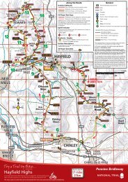
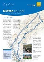
<strong>The</strong> <strong>Lower</strong> <strong>Ouseburn</strong> <strong>Valley</strong> & Jesmond Vale 41/2 miles / 7km Suggested starting point: Quayside/Glasshouse<br />
Bridge or Cradlewell<br />
Scale of map<br />
Kilometres<br />
Miles<br />
This walk can be linked with the<br />
Jesmond Dene route Lord<br />
Armstrong’s Back Garden to make<br />
a circular walk of 6 1 /2 miles / 11km.<br />
Gradients<br />
Glasshouse<br />
Bridge City Stadium<br />
Coulson’s<br />
Armstrong<br />
Bridge<br />
Statue<br />
Jesmond Vale<br />
2 3<br />
1<br />
4<br />
5<br />
Kilometres<br />
Miles<br />
1<br />
2 3<br />
1 2<br />
0.5<br />
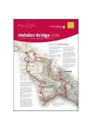
6 Former site of mill dam at Greenwater Pool<br />
5 <strong>The</strong> remains of the Jesmond Vale flint<br />
mill can be seen here. Flint was brought<br />
into the Tyne as ballast on ships, and<br />
was ground in the mill for use as glaze<br />
in the pottery industry.<br />
Picture: Ad Infinitum<br />
Picture: Newcastle City Council<br />
Picture: Newcastle City Libraries<br />
2<br />
Colonel Coulson’s<br />
statue (originally<br />
erected 1914) has<br />
two fountains, one<br />
for humans & the<br />
other for animals.<br />
1<br />
4<br />
200 years of bridging<br />
the <strong>Ouseburn</strong> – Byker<br />
Metro Bridge towers<br />
over the 18th century<br />
Crawford’s Bridge.<br />
Glasshouse Bridges old and new – the former<br />
packhouse bridge in the 19th century, and the<br />
river mouth as it is today.<br />
Picture: Newcastle City Council<br />
WARWICK ST.<br />
Heaton<br />
Park<br />
6<br />
DINSDALE RD.<br />
NEWINGTON RD.<br />
Jesmond<br />
Vale<br />
SPRINGBANK RD.<br />
CHELMSFORD RD.<br />
City<br />
Stadium<br />
••• • ••••• • •• • •••••••• ••• ••<br />
• • • ••<br />
•• • •• • • •• • • • •<br />
Seven Stories<br />
the Center for<br />
<strong>The</strong> Childrens Book<br />
CRADLEWELL BYPASS<br />
1/2<br />
River Tyne<br />
4 5 6 7<br />
3 4<br />
•••••<br />
Glasshouse<br />
City Stadium Bridge<br />
<strong>Lower</strong><br />
<strong>Ouseburn</strong><br />
7<br />
5<br />
METRO BRIDGE<br />
STRATFORD GR. W.<br />
CITY ROAD<br />
4<br />
HORATIO ST.<br />
Armstrong<br />
Bridge<br />
BENTON BANK<br />
HOTSPUR ST.<br />
NEWINGTON RD.<br />
BYKER BRIDGE<br />
LIME ST.<br />
BYKER<br />
FARM<br />
THE<br />
CLUNY<br />
BLUE BELL<br />
PUB<br />
VIADUCT<br />
CUT BANK<br />
3<br />
Links to the North/<br />
City Orbital<br />
SCHOOL<br />
•••••••• ••••••••• • • • • ••<br />
OUSE ST.<br />
2<br />
• • • • • • •• • • •• • •• • • • • •• • • •• • •<br />
FOUNDRY LANE<br />
VICTORIA<br />
TUNNEL<br />
LANSDOWNE GARDENS<br />
JESMOND VAL E<br />
GLASSHOUSE<br />
BRIDGE<br />
•• • • • • •• •• ••<br />
6<br />
• • • •<br />
• • •• • • •• • • • • • •<br />
• • • • •• • •• •<br />
Armstrong<br />
Park<br />
Heaton<br />
Park<br />
• • • • •• • • • •• • •• ••• • • ••• • • • •• • ••••<br />
BYKER BANK<br />
HUME ST.<br />
A1058<br />
A<br />
FORD ST.<br />
O USEB URN RD.<br />
ok<br />
MALING ST.<br />
1<br />
OUSEBURN RD.<br />
BENTON BANK<br />
BRIDGE<br />
CITY ROAD<br />
TYNE<br />
PUB<br />
OUSEBURN<br />
WATER<br />
SPORTS<br />
A186<br />
8<br />
A1058 COAST ROAD<br />
•• • • • • • •<br />
N<br />
W E<br />
3 <strong>The</strong> Sailor’s Bethel was a Danish<br />
Seaman’s Church & was renovated<br />
in 1992 to be used as offices.<br />
7<br />
HEATON PARK VIEW<br />
HORATIO ST.<br />
WALKER ROAD<br />
LIME ST.<br />
River Tyne<br />
3<br />
Picture: Newcastle Document Services<br />
S<br />
CUT BANK<br />
7<br />
This leaflet can be used in<br />
conjunction with Ordnance<br />
Survey Explorer Map 316<br />
Newcastle Upon Tyne<br />
Close to the east entrance of<br />
Heaton Park, once part of the Ridley<br />
family’s Heaton Estate, a temple<br />
like building was constructed and<br />
presented to Sir Matthew White<br />
Ridley by his tenants & admirers.<br />
OUSE ST.<br />
VICTORIA<br />
TUNNEL<br />
2<br />
LANE<br />
••••• • • • • ••<br />
BYKER BANK<br />
HUME ST.<br />
GLASSHOUS<br />
E<br />
8 Ballast from sailing ships was<br />
dumped here at Ballast Hills. <strong>The</strong><br />
area later became a non-conformist<br />
burial ground, and many of the<br />
gravestones have been used to flag<br />
the paths.<br />
Key to map<br />
A<br />
FORD ST.<br />
MALING ST.<br />
1<br />
TYNE<br />
PUB<br />
OUSEBURN<br />
WATER<br />
SPORTS<br />
A186<br />
Main route<br />
Alternative route<br />
(welly walk)<br />
Alternative route<br />
Hadrian’s Way<br />
Slope<br />
Steps<br />
Parking<br />
Information Board<br />
Public Art<br />
8