The Lower Ouseburn Valley
The Lower Ouseburn Valley
The Lower Ouseburn Valley

Create successful ePaper yourself
Turn your PDF publications into a flip-book with our unique Google optimized e-Paper software.
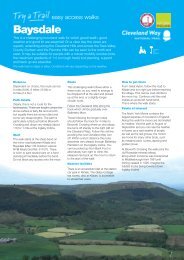
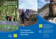
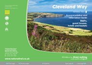
Exploring Hadrian’s Way<br />
<strong>The</strong> <strong>Lower</strong> <strong>Ouseburn</strong><br />
<strong>Valley</strong> & Jesmond Vale<br />
Up to 4 1/2 miles / 7km<br />
Newcastle’s Historic <strong>Valley</strong><br />
In terms of its history, the<br />
<strong>Ouseburn</strong> <strong>Valley</strong> is one of the<br />
gems of northern England.<br />
Along the steep valley sides you<br />
will find evidence of the<br />
industries for which Newcastle<br />
was famous even before the<br />
days of railways and<br />
shipbuilding. Lead products,<br />
ironware, glass, pottery, lime and<br />
soaps were all manufactured<br />
along the <strong>Ouseburn</strong>.<br />
<strong>The</strong> <strong>Lower</strong> <strong>Ouseburn</strong> is tidal up<br />
to Crawford’s Bridge, and so<br />
small boats could transfer their<br />
cargoes directly to and from the<br />
warehouses which lined the<br />
river. Most of these industries<br />
used the river as a drain to carry<br />
away their waste products.<br />
Because of this pollution, 200<br />
years ago the <strong>Lower</strong> <strong>Ouseburn</strong><br />
<strong>Valley</strong> would not have been a<br />
healthy place to live and work.<br />
However, many people did live in<br />
the <strong>Lower</strong> <strong>Ouseburn</strong>. In the 19th<br />
century terraced streets clung to<br />
the valley sides and houses<br />
clustered along the river itself.<br />
Many of these survived until the<br />
1960s when much of the area<br />
was cleared for redevelopment.<br />
Front cover: <strong>Lower</strong> <strong>Ouseburn</strong> – Ad Infinitum<br />
Bridges over Bridges<br />
<strong>The</strong> River Tyne is renowned for<br />
its bridges, but the <strong>Ouseburn</strong><br />
<strong>Valley</strong> has some magnificent<br />
examples of its own. <strong>The</strong> <strong>Lower</strong><br />
<strong>Valley</strong> is dominated by three<br />
huge structures.<br />
<strong>The</strong> <strong>Ouseburn</strong> Viaduct carries<br />
the railway and was originally<br />
built partly of timber. It was later<br />
widened and rebuilt in cast-iron.<br />
<strong>The</strong> Byker Road Bridge is<br />
supported on impressive brickarched<br />
piers. It was originally<br />
used to carry the tram-lines from<br />
the city out to Byker and beyond<br />
and now carries cars.<br />
<strong>The</strong> Metro Bridge, 4 opened 20<br />
years ago, has a box concrete<br />
construction which is immensely<br />
strong but relatively light.<br />
Crawford’s Bridge 4 sits<br />
beneath these huge structures.<br />
It was built in the18th century<br />
and is now one of the oldest<br />
bridges in Newcastle.<br />
At the mouth of the <strong>Ouseburn</strong> is<br />
Glasshouse Bridge. An earlier<br />
packhouse bridge was<br />
demolished when the Quayside<br />
Railway was extended in 1908.<br />
Based upon the 2000 Ordnance Survey map<br />
with permission of the Controller of H.M.S.O<br />
Crown Copyright Reserved LA 076244<br />
ı ı ı ı ı ı ı ı<br />
A1 WESTERN BY-PASS<br />
Location of walk<br />
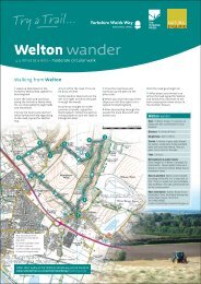
Discover one of Newcastle’s<br />
lesser known corners on this<br />
varied and fascinating 41/2 mile /<br />
7 km walk in the <strong>Lower</strong><br />
<strong>Ouseburn</strong> <strong>Valley</strong>. From the<br />
colourful boats at the mouth of<br />
the <strong>Ouseburn</strong> to the quiet<br />
tranquillity of Jesmond Vale, this<br />
is a walk with something for<br />
everyone.<br />
<strong>The</strong> route can be joined at any<br />
point and can be followed in<br />
either direction.<br />
Frequent bus services run to<br />
Byker Bridge and Benton Bank,<br />
and the walk can also be<br />
reached from the Metro stations<br />
at Manors and Byker.<br />
Designated parking areas are<br />
indicated on the map.<br />
Victoria Tunnel<br />
A186 WEST ROAD<br />
A191<br />
Gosforth<br />
TOWN<br />
MOOR<br />
A167<br />
ı ı ı ı ııı ı ı ı ıı ıı ı ı ı ı ı ı ı ı ı ı ı ı ı ı ı ı ı ı ı ı ı ı ı ı ı ı ı ı ı ı ı ı ı ı ı ı ı ı ı ı ı ı ı ı ı ı ı ı ı<br />
In 1839 work started on a tunnel<br />
that would carry coal from the<br />
Spital Tongues colliery in the<br />
North West of Newcastle, down<br />
to the river Tyne. <strong>The</strong> tunnel was<br />
built to avoid coal being<br />
transported through the busy<br />
city streets.<br />
Victoria Tunnel was opened in<br />
1842. It was 2 miles long and the<br />
total descent of the tunnel from<br />
the colliery to the Tyne was<br />
68m/222ft.<br />
<strong>The</strong> tunnel was an efficient way<br />
of transporting coal. Wagons<br />
travelled down to the Tyne under<br />
the force of gravity and a steam<br />
engine at the colliery pulled the<br />
empty trucks back up to Spital<br />
Tongues.<br />
<strong>The</strong> tunnel was closed in 1860.<br />
During the Second World War<br />
the tunnel was reopened as an<br />
air-raid shelter.<br />
ı ı ı ı ı ı ı ı ı ı ı ı ı ı ı ı ı ı ı ı ı ı ı ı ı ı ı ı ı ı ı ııı ı ı ı ı ı ı ı ı ı ı ı ı ı<br />
ı ı ı ı ı ı ı ııııııı ı ı ı<br />
Contact details:<br />
Traveline<br />
Tel: 0870 608 2608<br />
www.traveline.org.uk<br />
Hadrian's Wall Information Line<br />
Tel: 01434 322002<br />
www.hadrians-wall.org<br />
Newcastle Tourist<br />
Information Centre<br />
Tel: 0191 2778000<br />
To give feedback on these &<br />
other strategic routes in and<br />
around Newcastle,<br />
please contact:<br />
John Robertson,<br />
Newcastle City Council<br />
Planning & Transportation<br />
Tel: 0191 232 8520<br />
A Lost Village<br />
<strong>The</strong> old village of Jesmond Vale<br />
used to sit amongst fields in the<br />
bottom of the <strong>Ouseburn</strong> <strong>Valley</strong>, a<br />
tranquil haven away from the<br />
bustle of the city.<br />
<strong>The</strong> village had three pubs, a<br />
farm and a mill beside the river.<br />
<strong>The</strong> remains of the mill 5 can<br />
still be seen, and the leat which<br />
fed it can be traced back to the<br />
mill dam at Greenwater Pool 6 .<br />
Originally a corn mill, it was later<br />
adapted to grind flint for use as<br />
glaze in the pottery industry. Flint<br />
was brought into the Tyne as<br />
ballast on cargo ships and was<br />
then carted up to the mills on the<br />
<strong>Ouseburn</strong>, hence Ballast Hills 7 .<br />
<strong>The</strong> bulk of the old village was<br />
demolished in the 1960’s when<br />
the Vale was earmarked for<br />
redevelopment. Of the three<br />
pubs only the Bluebell Inn<br />
survived.<br />
Designed by Ad Infinitum, Rothbury. Published by Newcastle City Council © 2002<br />
GREAT NORTH ROAD<br />
ST. JAMES’<br />
PARK<br />
Newcastle<br />
M<br />
M<br />
M<br />
ı ı ı ı ı ı ı ı<br />
ı ı ı ı ı ııııı ı ı ı ıı ı ı ıııı ı ı<br />
M<br />
M<br />
ı ı ı ı<br />
ı ı ı ı ı ı ıı ı ı ı<br />
Jesmond<br />
M<br />
ı ı<br />
A1058<br />
ı ı ı ı ı ı ı ı ı ı ıı ı ı ııı ı ı ı ı ı ı ı ı ı ıııı ı ı ı ı ı ı ı ı ı ı ı ı ı ı ı ı ı ı<br />
A191<br />
M<br />
M<br />
ı ı ı ı ı ı ı ı ı ı ı ı ı ı ı ı ı ı ı ı ı ı ı ı ı ı ııı ııı ı ı ı ı ı ı ı ı ı ı ı ı ı ı ı ı ı ı ı ı ı ı ı ı ı ı ı ı ı ı<br />
Heaton<br />
M<br />
A1058 COAST ROAD<br />
ı ı ı ı ıı ı ı ı ı ı ı ı ı ı ı ı ı ı ı ı ı ı ı ı ı ı ı ı ı ı ı ı ı ı ı ı ı ı ı ı ı ı ı ı ı ı ı ı ı ı ı ı ı ı ı ı ı ı ı ı ı ı ı ı ı ı ı ı ı ı ı ı ı ı ı ı ı ı ı ı ı ı ı ı ı ı ı ı ı ı ı ı ı ı ı ı ı ı ı ı ı ı ı ı ı ı ı ı ı ı ı<br />
TYNE<br />
BRIDGE<br />
FREEMAN<br />
HOSPITAL<br />
A186<br />
N<br />
ı ı ı ı ı ı ı ı ı ı ı ı ı ı ı ı ı ı ı ı ı ı ı ı ı ı ı ı ı
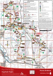
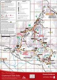
<strong>The</strong> <strong>Lower</strong> <strong>Ouseburn</strong> <strong>Valley</strong> & Jesmond Vale 41/2 miles / 7km Suggested starting point: Quayside/Glasshouse<br />
Bridge or Cradlewell<br />
Scale of map<br />
Kilometres<br />
Miles<br />
This walk can be linked with the<br />
Jesmond Dene route Lord<br />
Armstrong’s Back Garden to make<br />
a circular walk of 6 1 /2 miles / 11km.<br />
Gradients<br />
Glasshouse<br />
Bridge City Stadium<br />
Coulson’s<br />
Armstrong<br />
Bridge<br />
Statue<br />
Jesmond Vale<br />
2 3<br />
1<br />
4<br />
5<br />
Kilometres<br />
Miles<br />
1<br />
2 3<br />
1 2<br />
0.5<br />
6 Former site of mill dam at Greenwater Pool<br />
5 <strong>The</strong> remains of the Jesmond Vale flint<br />
mill can be seen here. Flint was brought<br />
into the Tyne as ballast on ships, and<br />
was ground in the mill for use as glaze<br />
in the pottery industry.<br />
Picture: Ad Infinitum<br />
Picture: Newcastle City Council<br />
Picture: Newcastle City Libraries<br />
2<br />
Colonel Coulson’s<br />
statue (originally<br />
erected 1914) has<br />
two fountains, one<br />
for humans & the<br />
other for animals.<br />
1<br />
4<br />
200 years of bridging<br />
the <strong>Ouseburn</strong> – Byker<br />
Metro Bridge towers<br />
over the 18th century<br />
Crawford’s Bridge.<br />
Glasshouse Bridges old and new – the former<br />
packhouse bridge in the 19th century, and the<br />
river mouth as it is today.<br />
Picture: Newcastle City Council<br />
WARWICK ST.<br />
Heaton<br />
Park<br />
6<br />
DINSDALE RD.<br />
NEWINGTON RD.<br />
Jesmond<br />
Vale<br />
SPRINGBANK RD.<br />
CHELMSFORD RD.<br />
City<br />
Stadium<br />
••• • ••••• • •• • •••••••• ••• ••<br />
• • • ••<br />
•• • •• • • •• • • • •<br />
Seven Stories<br />
the Center for<br />
<strong>The</strong> Childrens Book<br />
CRADLEWELL BYPASS<br />
1/2<br />
River Tyne<br />
4 5 6 7<br />
3 4<br />
•••••<br />
Glasshouse<br />
City Stadium Bridge<br />
<strong>Lower</strong><br />
<strong>Ouseburn</strong><br />
7<br />
5<br />
METRO BRIDGE<br />
STRATFORD GR. W.<br />
CITY ROAD<br />
4<br />
HORATIO ST.<br />
Armstrong<br />
Bridge<br />
BENTON BANK<br />
HOTSPUR ST.<br />
NEWINGTON RD.<br />
BYKER BRIDGE<br />
LIME ST.<br />
BYKER<br />
FARM<br />
THE<br />
CLUNY<br />
BLUE BELL<br />
PUB<br />
VIADUCT<br />
CUT BANK<br />
3<br />
Links to the North/<br />
City Orbital<br />
SCHOOL<br />
•••••••• ••••••••• • • • • ••<br />
OUSE ST.<br />
2<br />
• • • • • • •• • • •• • •• • • • • •• • • •• • •<br />
FOUNDRY LANE<br />
VICTORIA<br />
TUNNEL<br />
LANSDOWNE GARDENS<br />
JESMOND VAL E<br />
GLASSHOUSE<br />
BRIDGE<br />
•• • • • • •• •• ••<br />
6<br />
• • • •<br />
• • •• • • •• • • • • • •<br />
• • • • •• • •• •<br />
Armstrong<br />
Park<br />
Heaton<br />
Park<br />
• • • • •• • • • •• • •• ••• • • ••• • • • •• • ••••<br />
BYKER BANK<br />
HUME ST.<br />
A1058<br />
A<br />
FORD ST.<br />
O USEB URN RD.<br />
ok<br />
MALING ST.<br />
1<br />
OUSEBURN RD.<br />
BENTON BANK<br />
BRIDGE<br />
CITY ROAD<br />
TYNE<br />
PUB<br />
OUSEBURN<br />
WATER<br />
SPORTS<br />
A186<br />
8<br />
A1058 COAST ROAD<br />
•• • • • • • •<br />
N<br />
W E<br />
3 <strong>The</strong> Sailor’s Bethel was a Danish<br />
Seaman’s Church & was renovated<br />
in 1992 to be used as offices.<br />
7<br />
HEATON PARK VIEW<br />
HORATIO ST.<br />
WALKER ROAD<br />
LIME ST.<br />
River Tyne<br />
3<br />
Picture: Newcastle Document Services<br />
S<br />
CUT BANK<br />
7<br />
This leaflet can be used in<br />
conjunction with Ordnance<br />
Survey Explorer Map 316<br />
Newcastle Upon Tyne<br />
Close to the east entrance of<br />
Heaton Park, once part of the Ridley<br />
family’s Heaton Estate, a temple<br />
like building was constructed and<br />
presented to Sir Matthew White<br />
Ridley by his tenants & admirers.<br />
OUSE ST.<br />
VICTORIA<br />
TUNNEL<br />
2<br />
LANE<br />
••••• • • • • ••<br />
BYKER BANK<br />
HUME ST.<br />
GLASSHOUS<br />
E<br />
8 Ballast from sailing ships was<br />
dumped here at Ballast Hills. <strong>The</strong><br />
area later became a non-conformist<br />
burial ground, and many of the<br />
gravestones have been used to flag<br />
the paths.<br />
Key to map<br />
A<br />
FORD ST.<br />
MALING ST.<br />
1<br />
TYNE<br />
PUB<br />
OUSEBURN<br />
WATER<br />
SPORTS<br />
A186<br />
Main route<br />
Alternative route<br />
(welly walk)<br />
Alternative route<br />
Hadrian’s Way<br />
Slope<br />
Steps<br />
Parking<br />
Information Board<br />
Public Art<br />
8