State Park - Texas Parks & Wildlife Department
State Park - Texas Parks & Wildlife Department State Park - Texas Parks & Wildlife Department
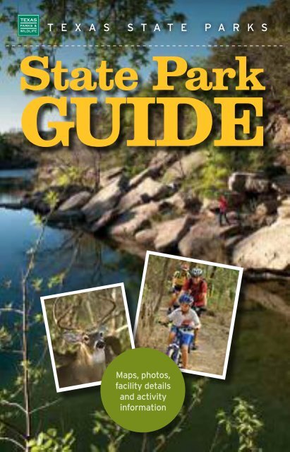
T E X A S S T A T E P A R K S State Park GUIDE Maps, photos, facility details and activity information
- Page 2 and 3: 2012 TOYOTA TUNDRA LOSE THE MAPS. F
- Page 4 and 5: CONTENTS 6 Day Tripper When it come
- Page 6 and 7: THINGS TO DO Outdoor Family Fun in
- Page 8 and 9: PLACES TO GO Day Tripper WHEN IT CO
- Page 10 and 11: Houston Area Great fishing and wild
- Page 12 and 13: San Antonio Area Government Canyon
- Page 14 and 15: Austin Area Canoe rental at Inks La
- Page 16 and 17: THINGS TO BRING Packing it Up A bas
- Page 18 and 19: PLACES TO STAY Enjoy the Softer Sid
- Page 20 and 21: THINGS YOU MIGHT SEE Meet the Local
- Page 22 and 23: STATE PARKS DIRECTORY 23 31 45 55 6
- Page 24 and 25: S T A T E P A R K D I R E C T O R Y
- Page 26 and 27: P A N H A N D L E P L A I N S R E G
- Page 28 and 29: P A N H A N D L E P L A I N S R E G
- Page 30 and 31: Operations or access has changed at
- Page 32 and 33: S T A T E P A R K D I R E C T O R Y
- Page 34 and 35: Devil’s Sinkhole State Natural Ar
- Page 36 and 37: Garner State Park 234 R.R. 1050, Co
- Page 38 and 39: Hill Country State Natural Area 106
- Page 40 and 41: Lake Brownwood State Park 200 State
- Page 42 and 43: Lyndon B. Johnson State Park and Hi
- Page 44: South Llano River State Park 1927 P
- Page 47 and 48: B I G B E N D C O U N T R Y R E G I
- Page 49 and 50: B I G B E N D C O U N T R Y R E G I
- Page 51 and 52: Wish you were HERE. Monahans SP FRE
T E X A S S T A T E P A R K S<br />
<strong>State</strong> <strong>Park</strong><br />
GUIDE<br />
Maps, photos,<br />
facility details<br />
and activity<br />
information
2012 TOYOTA TUNDRA<br />
LOSE THE MAPS.<br />
FIND SOME<br />
ADVENTURE.<br />
The 2012 Tundra is big, it’s bold, and it’s J.D. Power<br />
and Associates’ Most Dependable Large Pickup,<br />
7 years running. So get in, or get out of the way.<br />
OFFICIAL VEHICLE OF<br />
THE TEXAS PARKS AND<br />
WILDLIFE FOUNDATION<br />
OFFICIAL VEHICLE OF<br />
THE TOYOTA TEXAS<br />
BASS CLASSIC
The Toyota Tundra received the lowest number of problems per 100 vehicles among large pickups in<br />
the proprietary J.D. Power and Associates 2006-2012 Vehicle Dependability Studies SM . 2012 study<br />
based on 31,325 consumer responses measuring problems consumers experienced in the past 12<br />
months with three-year-old vehicles (2009 model-year cars and trucks). Proprietary study results<br />
are based on experiences and perceptions of consumers surveyed October-December 2011. Your<br />
experiences may vary. Visit jdpower.com.
CONTENTS<br />
6<br />
Day Tripper<br />
When it comes to escaping the city for a quick<br />
day trip or a relaxing weekend, many <strong>Texas</strong><br />
state parks are just a skip away.<br />
21<br />
<strong>State</strong> <strong>Park</strong>s Regional<br />
Directory<br />
23<br />
31<br />
45<br />
61<br />
81<br />
91<br />
99<br />
55<br />
110<br />
Panhandle Plains<br />
Hill Country<br />
Big Bend Country<br />
Prairies and Lakes<br />
Gulf Coast<br />
South <strong>Texas</strong> Plains<br />
Pineywoods<br />
<strong>State</strong> <strong>Park</strong> User Fees<br />
Facilities & Activities Index<br />
56 <strong>State</strong> <strong>Park</strong>s Map<br />
Cover photo: Dinosaur Valley <strong>State</strong> <strong>Park</strong>, Chase Fountain<br />
<strong>Texas</strong> <strong>State</strong> <strong>Park</strong> Guide Ninth Edition © 2012 TPWD PWD BK P4000-000A (05/12)<br />
Features<br />
Things to Do<br />
Places to Go<br />
Things to Bring<br />
Places to Stay<br />
Things You Might See<br />
TEXAS PARKS AND<br />
WILDLIFE DEPARTMENT<br />
Carter P. Smith Executive Director<br />
Brent Leisure Director of <strong>State</strong> <strong>Park</strong>s<br />
Lydia Saldaña Communications Director<br />
TPW COMMISSION<br />
T. Dan Friedkin, Chairman, Houston<br />
Ralph H. Duggins,Vice-Chairman, Fort Worth<br />
Antonio Falcon, M.D., Rio Grande City<br />
Karen J. Hixon, San Antonio<br />
Dan Allen Hughes, Jr., Beeville<br />
Bill Jones, Austin<br />
Margaret Martin, Boerne<br />
S. Reed Morian, Houston<br />
Dick Scott, Wimberley<br />
Lee M. Bass, Chairman-Emeritus, Fort Worth<br />
Special thanks to Toyota and advertisers, whose<br />
generous support made this guide possible.<br />
TPWD receives federal assistance from the U.S. Fish and <strong>Wildlife</strong> Service and other federal agencies and is subject to Title VI of the Civil Rights Act<br />
of 1964, Section 504 of the Rehabilitation Act of 1973, Title II of the Americans with Disabilities Act of 1990, the Age Discrimination Act of 1975, Title<br />
IX of the Education Amendments of 1972, and state anti-discrimination laws which prohibit discrimination the basis of race, color, national origin, age,<br />
sex or disability. If you believe that you have been discriminated against in any TPWD program, activity or facility, or need more information, please<br />
contact Civil Rights Coordinator for Public Access, U.S. Fish and <strong>Wildlife</strong> Service, 4401 N. Fairfax Drive, Mail Stop: MBSP-4020, Arlington, VA 22203.<br />
In accordance with <strong>Texas</strong> <strong>State</strong> Depository Law, this publication is available at the <strong>Texas</strong> <strong>State</strong> Publications Clearinghouse and/or <strong>Texas</strong><br />
Depository Libraries.<br />
4<br />
6<br />
14<br />
16<br />
18<br />
Meet some of the<br />
diverse residents of<br />
<strong>Texas</strong> <strong>State</strong> <strong>Park</strong>s.
STATE PARKS UPDATE<br />
An important message<br />
for <strong>State</strong> <strong>Park</strong> Visitors<br />
from Brent Leisure, <strong>State</strong> <strong>Park</strong>s Director<br />
<strong>Texas</strong> <strong>State</strong> <strong>Park</strong>s are unique and beautiful places<br />
with rich stories to share and a wide range of outdoor<br />
opportunities to enjoy. During your visit, I encourage<br />
you to take an interpretive tour or attend a scheduled<br />
activity to experience what makes our land, resources<br />
and history so special.<br />
I also want to inform you of some recent changes. We are pleased to report that many<br />
park improvement and repair projects that were funded from previous legislatures are<br />
now complete or almost finished. This includes upgrades and renovations to cabins,<br />
campsites, restrooms, group facilities, playgrounds, roads and other amenities at dozens<br />
of parks.<br />
However, as you are undoubtedly aware, the entire country continues to experience<br />
difficult economic times. These challenges have affected all levels of government as<br />
well as families. Even so, our state parks remain affordable, safe and family-friendly<br />
destinations. As part of our belt-tightening, we have modified or reduced hours of<br />
operation at some parks. These sites have been denoted with a special icon in this<br />
publication; we encourage everyone to check www.texasstateparks.org/access<br />
or call our Customer Service Center for updates at (512) 389-8900 in advance of<br />
your trip.<br />
There are also ways that you can help us keep parks open and maintained. You<br />
can make a donation online, or when renewing your vehicle, boat or trailer registration.<br />
In addition, your entrance, camping and park pass fees, and your park<br />
store purchases also help directly fund parks. Find out more about how you can<br />
help at www.texasstateparks.org/help<br />
On behalf of all of our dedicated and professional staff, welcome to <strong>Texas</strong> <strong>State</strong> <strong>Park</strong>s.<br />
We hope you thoroughly enjoy your stay and leave with wonderful memories, and a<br />
greater appreciation for the natural and cultural resources we are preserving for you<br />
and future generations.
THINGS TO DO<br />
Outdoor Family Fun<br />
in <strong>Texas</strong> <strong>State</strong> <strong>Park</strong>s<br />
<strong>Texas</strong> <strong>State</strong> <strong>Park</strong>s are great places for family outdoor fun, and<br />
research shows that spending time in nature is good for your<br />
children’s mental and physical well being. This prescription for<br />
better health is one of the best values for your money. Plus<br />
we’ve introduced several programs that make enjoying the<br />
outdoors easier than ever.<br />
No License Needed<br />
Did you know that no one needs a fishing<br />
license or stamp to fish inside the boundaries<br />
of a <strong>Texas</strong> <strong>State</strong> <strong>Park</strong>? Regardless of<br />
age, or where you’re from, the Free Fishing<br />
in <strong>State</strong> <strong>Park</strong>s program makes it possible<br />
to fish anytime you like, once you’ve<br />
entered the park, no license required. Some<br />
parks have equipment you can borrow<br />
through our Tackle Loaner Program.<br />
Go Fish!<br />
Learn-To-Fish events provide all the necessary<br />
instruction and equipment (including<br />
bait!) to get you started. Children can even<br />
win prizes, including fishing equipment<br />
and other outdoor<br />
gear. The events are<br />
free to all park visitors<br />
who have paid park<br />
entrance fees.<br />
Telephone Reservations / 4 / (512) 389-8900<br />
<strong>Texas</strong><br />
Outdoor Family<br />
The <strong>Texas</strong> Outdoor Family program is<br />
designed to teach you and your family<br />
basic outdoor skills needed to enjoy a<br />
great overnight camping experience.<br />
Workshops are hosted at state parks<br />
for hands-on experience with camping,<br />
outdoor cooking, orienteering and<br />
various outdoor activities such as kayaking,<br />
fishing or wildlife watching. No<br />
experience or equipment is necessary!<br />
Our highly skilled outdoor specialists and<br />
trained volunteers offer the experience<br />
and the equipment.<br />
You just<br />
bring the food<br />
and enthusiasm!
Geocache Challenge<br />
Combine the thrill of treasure hunting with the precision of global positioning devices,<br />
and you’ve got geocaching! The <strong>Texas</strong> <strong>State</strong> <strong>Park</strong>s Geocache Challenge brings this<br />
popular pastime to participating state parks. All you’ll need is a GPS unit (or mobile<br />
phone that has a global positioning feature), the coordinates for the hidden treasure<br />
(or caches), and a free <strong>Texas</strong> <strong>State</strong> <strong>Park</strong> Geocache Challenge<br />
Passport Book (downloadable from the TPWD website). Each cache<br />
is hidden somewhere within the park; inside it you’ll find small prizes,<br />
a logbook, a special orienteering punch, and facts about the park.<br />
Don’t know how to geocache? Selected state parks host “how-to<br />
geocache” workshops throughout the year. GPS units are provided.<br />
<strong>Texas</strong> state parks belong to you and future generations to experience.<br />
To help take care of the park, here are some things to remember: leave no<br />
trace; if you pack it in, then pack it out; stay on trails and tread lightly;<br />
don’t take anything from the park<br />
(rocks, leaves, wood, etc.) as it is<br />
a crime to remove or damage any<br />
state property or resource; pick<br />
up litter; keep your dog on a leash<br />
and pick up after it.<br />
Kids Play Free!<br />
Admission to <strong>Texas</strong> <strong>State</strong> <strong>Park</strong>s is free for kids<br />
age 12 and younger. It’s more affordable than<br />
going to movies or amusement parks.<br />
Discovery and Interpretive Centers<br />
Dozens of state parks and historic sites have<br />
interpretive centers with fascinating exhibits that<br />
engage and educate visitors (shhhh, don’t tell<br />
the kids they’re learning!). Nature centers and<br />
living history museums illustrate the diversity of<br />
<strong>Texas</strong>’ wildlife, environment, and culture—past<br />
and present. And our newest discovery centers<br />
at Guadalupe River and Davis Mountains offer<br />
hands-on activities that will bring out every<br />
child’s inner explorer!<br />
texasstateparks.org<br />
Learn more—and start<br />
making priceless memories!<br />
Hours, Activities & Reservations / 5 / www.texasstateparks.org<br />
facebook.com/texasparksandwildlife
PLACES TO GO<br />
Day Tripper<br />
WHEN IT COMES TO ESCAPING THE CITY FOR A QUICK DAY TRIP<br />
OR A RELAXING WEEKEND, MANY STATE PARKS ARE RIGHT NEARBY.<br />
Dallas/Fort Worth Area<br />
Cedar Hill<br />
<strong>State</strong> <strong>Park</strong><br />
Located in the city limits<br />
of the metro suburb of<br />
Cedar Hill and inside<br />
Dallas County is an 1,800acre<br />
park and nature<br />
preserve that sits along<br />
the shoreline of 7,500-acre<br />
Joe Pool Reservoir. With<br />
two large boat ramps and<br />
Great water access at Cedar Hill SP.<br />
its own marina, Cedar<br />
Hill provides quick<br />
access to big water, but<br />
is quaint enough for a<br />
kayak. Cedar Hill is also<br />
a renowned biking park,<br />
with more than 12 miles<br />
of biking trails, and<br />
another 4.5 miles of<br />
hiking trails. The park<br />
also boasts an impressive<br />
350 developed campsites.<br />
Possum<br />
Kingdom<br />
FORT WORTH<br />
Dinosaur<br />
Valley<br />
287<br />
Fort<br />
Richardson<br />
Lake<br />
Mineral Wells<br />
Cleburne<br />
Lake Whitney<br />
Ray Roberts<br />
Lake <strong>State</strong> <strong>Park</strong><br />
“Ray Rob” is close enough<br />
to the metroplex to hit the<br />
water by lunchtime, and<br />
big enough to take the<br />
whole gang. With three<br />
park units, and five addi-<br />
Beautiful Lantana Lodge at<br />
Ray Roberts Lake SP.<br />
35<br />
Cedar<br />
Hill<br />
35W<br />
Ray Roberts Lake<br />
DALLAS<br />
Telephone Reservations / 6 / (512) 389-8900<br />
35E<br />
Eisenhower<br />
Cooper Lake<br />
Bonham<br />
30<br />
Lake Bob Sandlin<br />
Lake Tawakoni<br />
20<br />
Purtis Creek<br />
Tyler<br />
tional satellite park entry<br />
points, the sprawling park<br />
is located near the towns<br />
of Pilot Point and Sanger<br />
(about an hour to the<br />
north of DFW), and grants<br />
access from all sides to<br />
the 30,000 surface acres of<br />
fishing and skiing delight<br />
on this U.S. Corp of<br />
Engineers impoundment.<br />
The park has a marina, as<br />
well as overnight accommodations<br />
at Lantana<br />
Lodge. Or, camp if you<br />
want, in the more than<br />
200 developed campsites.
Eisenhower SP offers access to 70,000acre<br />
Lake Texoma north of DFW.<br />
Eisenhower<br />
<strong>State</strong> <strong>Park</strong><br />
Not to be overlooked,<br />
Eisenhower <strong>State</strong> <strong>Park</strong> to<br />
the north near Denison<br />
is located on the huge,<br />
74,000-acre Lake Texoma<br />
just up Highway 75 bordering<br />
the <strong>Texas</strong>-Oklahoma<br />
state line, and is legendary<br />
for its water fun. The park<br />
also has its own marina<br />
and yacht club, and lots of<br />
hiking trails to boot.<br />
Lake Tawakoni<br />
<strong>State</strong> <strong>Park</strong><br />
One of the newest state<br />
park units in the DFW<br />
area, the park is located<br />
just outside the town of<br />
Wills Point (an hour east<br />
of Dallas). In its entirety,<br />
the reservoir covers 36,000<br />
acres with some 200 miles<br />
of shoreline. The park rests<br />
on 376 acres and can make<br />
for a perfect day at the lake<br />
with its swim beach,<br />
a four-lane boat ramp and<br />
40 picnic sites.<br />
Cooper Lake<br />
<strong>State</strong> <strong>Park</strong><br />
Not far from the<br />
Metroplex to the east,<br />
Cooper Lake is located<br />
just north of I-30, near<br />
Sulphur Springs. The<br />
gateway to a 19,000-acre<br />
lake, the park offers miles<br />
of trails, a sandy beach<br />
and even cabins available<br />
for rent. Cooper is also<br />
considered a great fishing<br />
lake for largemouth and<br />
hybrid-striped bass.<br />
Lake Mineral<br />
Wells <strong>State</strong> <strong>Park</strong><br />
Lake Mineral Wells SP and Trailway<br />
features a 645-acre reservoir.<br />
West of Fort Worth, Lake<br />
Mineral Wells offers an<br />
intimate lake environment<br />
at 645 surface acres<br />
of water which can make<br />
for some great fishing.<br />
The park offers miles of<br />
trails for hiking, horseback<br />
riding, numerous<br />
campsites and even rock<br />
climbing as well.<br />
Possum<br />
Kingdom<br />
<strong>State</strong> <strong>Park</strong><br />
Lakeside camping at Possum Kingdom SP.<br />
“Ol’ P.K.”remains almost<br />
folkloric to this region<br />
of <strong>Texas</strong>, and beckons<br />
anglers, boaters, even<br />
scuba divers to its 17,000plus<br />
surface acres of clear,<br />
Hours, Activities & Reservations / 7 / www.texasstateparks.org<br />
deep-blue expanse, as<br />
it has for more than 50<br />
years. Visitors to Possum<br />
Kingdom <strong>State</strong> <strong>Park</strong> can<br />
also choose to camp or<br />
stay in one of the park’s<br />
seven cabins.<br />
Purtis Creek<br />
<strong>State</strong> <strong>Park</strong><br />
For bass fishing, check<br />
out this 1,500-acre park,<br />
southeast of Dallas near<br />
Eustace. Although the<br />
lake is only 355 acres, the<br />
angling action—which<br />
is catch-and-release for<br />
bass—can be outstanding.<br />
Fish from the bank, pier or boat at<br />
Purtis Creek SP.<br />
And since the lake is fully<br />
contained within the state<br />
park, no one ever needs a<br />
fishing license to fish anywhere<br />
at Purtis Creek.<br />
Fort Richardson<br />
<strong>State</strong> <strong>Park</strong><br />
Situated near a 385-surfaceacre<br />
lake, Fort Richardson<br />
features a restored frontier<br />
outpost—circa 1860s and<br />
1870s—in addition to its<br />
many recreational offerings.<br />
Quarry Lake at Fort Richardson SP.
Houston Area<br />
Great fishing and wildlife viewing at<br />
Brazos Bend SP.<br />
Brazos Bend<br />
<strong>State</strong> <strong>Park</strong><br />
Less than 30 miles southwest<br />
of the Houston<br />
skyline, Brazos Bend<br />
seems a world away. A<br />
preserve for more than<br />
300 adult American<br />
alligators and more than<br />
1,000 less than 6 feet in<br />
length, the 5,000-acre park<br />
features several lakes for<br />
fishing, a visitor center,<br />
huge live oak trees, and<br />
more than 30 miles of<br />
multiuse trails in addition<br />
to its water and electric<br />
campsites, primitive sites<br />
and screened shelters.<br />
Sheldon Lake<br />
<strong>State</strong> <strong>Park</strong><br />
Just east of Houston’s<br />
downtown is Sheldon<br />
Lake, a unique day-use<br />
park that features a unique<br />
educational facility, opportunities<br />
for nature study, a<br />
reservoir, and great<br />
fishing ponds for kids.<br />
San Jacinto<br />
Battleground<br />
and Battleship<br />
TEXAS <strong>State</strong><br />
Historic Sites<br />
Further to the southeast<br />
in La Porte, Battleship<br />
TEXAS and the San<br />
Lake Somerville<br />
Washington-on-the Brazos<br />
Brazos Bend<br />
Huntsville<br />
Monument Hill<br />
Kreische Brewery<br />
Stephen F. Austin<br />
Battleship TEXAS is the last remaining<br />
Dreadnought-type ship in the world.<br />
Jacinto Battleground<br />
stand as sentinels along<br />
the bay. Folks can tour the<br />
TEXAS—the only surviving<br />
Dreadnought to have<br />
served in World War I and<br />
World War II—as well as<br />
tour the famed battlefield<br />
site where <strong>Texas</strong> troops<br />
defeated Mexican forces<br />
under General Santa Anna<br />
in 1836.<br />
Stephen F. Austin<br />
<strong>State</strong> <strong>Park</strong><br />
To the west just off<br />
Interstate 10, Stephen F.<br />
Austin, near Sealy, pays<br />
homage to the “Father of<br />
<strong>Texas</strong>,” who established the<br />
first Anglo-American settlement<br />
in <strong>Texas</strong> in 1828.<br />
The park includes fullhookup<br />
campsites and the<br />
former town site of San<br />
Felipe, which was burned<br />
by the <strong>Texas</strong> army fleeing<br />
advancing Mexican troops<br />
in 1836.<br />
Fanthorp Inn<br />
HOUSTON<br />
10<br />
45<br />
San<br />
Jacinto<br />
Battleground<br />
Monument<br />
Hours, Activities & Reservations / 8 / www.texasstateparks.org<br />
Martin Dies, Jr.<br />
Lake Livingston<br />
Village Creek<br />
Sabine Pass<br />
Sheldon Lake<br />
Battleship<br />
<strong>Texas</strong><br />
Galveston Island<br />
Sea Rim<br />
Huntsville and<br />
Lake Livingston<br />
<strong>State</strong> <strong>Park</strong>s<br />
To Houston’s north, two<br />
pineywood retreats offer<br />
camping, hiking, horseback<br />
riding and great fishing.<br />
Huntsville has group facilities<br />
built by the Civilian<br />
Conservation Corp, while<br />
Livingston has a swimming<br />
pool and access to a giant<br />
84,000-surface-acre reservoir.<br />
Village Creek<br />
<strong>State</strong> <strong>Park</strong><br />
Just north of Beaumont<br />
and east of Houston,<br />
Village Creek offers great<br />
paddling along the creek or<br />
hiking among the nearly<br />
2,500 acres of huge pine<br />
and magnolia trees in the<br />
heart of the Old <strong>Texas</strong> Big<br />
Thicket. Enjoy primitive<br />
camping, water and electric<br />
campsites and even an<br />
eight-person cabin.<br />
Village Creek SP is famous for paddling.
Let’s Get Outside ®<br />
Whole Earth Provision Co.<br />
Since 1970<br />
Outfitting <strong>Texas</strong> for<br />
Travel, Adventure, and FUN!<br />
2410 San Antonio Street Austin 512-478-1577<br />
1014 North Lamar Austin 512-476-1414<br />
South Lamar at Westgate Austin 512-899-0992<br />
5400 East Mockingbird Ln. Dallas 214-824-7444<br />
Preston Forest Center Dallas 972-861-5700<br />
2934 South Shepherd Dr. Houston 713-526-5226<br />
2501 Post Oak Blvd. Houston 713-526-5440<br />
The Quarry Market San Antonio 210-829-8888<br />
WholeEarthProvision.com
San Antonio Area<br />
Government<br />
Canyon <strong>State</strong><br />
Natural Area<br />
Government Canyon <strong>State</strong> Natural Area<br />
has more than 40 miles of scenic trails.<br />
Just a stone’s throw beyond<br />
northwest San Antonio’s<br />
Loop 1604, in Helotes, is<br />
a premier hike-and-bike<br />
day-use park. With more than<br />
8,600 acres and more than<br />
40-plus miles of trails, this<br />
rugged park also protects<br />
some of the precious Edwards<br />
Aquifer recharge zone.<br />
Guadalupe<br />
River <strong>State</strong> <strong>Park</strong><br />
Guadalupe River <strong>State</strong><br />
<strong>Park</strong> is located north up<br />
Hwy. 281 between Boerne<br />
and New Braunfels. The<br />
park stretches along four<br />
scenic miles of river frontage<br />
and provides access to<br />
the Guadalupe River—long<br />
Scenery, fishing and tubing are great at<br />
Guadalupe River SP.<br />
South Llano River<br />
Guadalupe River/<br />
Lost Maples Honey Creek<br />
Hill Country<br />
Garner<br />
Choke Canyon<br />
considered the premier<br />
place for summertime<br />
tubing in <strong>Texas</strong>. Honey<br />
Creek <strong>State</strong> Natural<br />
Area is also located<br />
within the park. With its<br />
huge bald cypress trees, it<br />
is accessible only through<br />
guided tours, and preserves<br />
more than 2,000<br />
acres of pristine woods.<br />
South Llano<br />
River <strong>State</strong> <strong>Park</strong><br />
Farther out west is South<br />
Llano River <strong>State</strong> <strong>Park</strong>,<br />
another tubing hot spot<br />
along the South Llano<br />
River just off Interstate 10,<br />
near the town of Junction.<br />
Garner<br />
<strong>State</strong> <strong>Park</strong><br />
Despite its somewhat<br />
remote location near the<br />
small town of Leakey,<br />
Garner is one of the most<br />
frequently visited state<br />
parks in <strong>Texas</strong> and for<br />
decades has been considered<br />
great for camping,<br />
swimming, tubing and<br />
kayaking—and don’t forget<br />
the famous Garner <strong>State</strong><br />
<strong>Park</strong> dance during warm<br />
summer evenings.<br />
Telephone Reservations / 10 / (512) 389-8900<br />
10<br />
87<br />
Government<br />
Canyon<br />
290<br />
1604<br />
281<br />
35 37<br />
AAUUSSTIN A<br />
290 290<br />
183<br />
Lockhart<br />
SAN ANTONIO<br />
Goliad<br />
Palmetto<br />
Lake<br />
Corpus Christi<br />
Find great hiking trails at CCC-built<br />
Palmetto SP.<br />
Palmetto<br />
<strong>State</strong> <strong>Park</strong><br />
Near the towns of Luling<br />
and Gonzales, Palmetto<br />
<strong>State</strong> <strong>Park</strong>—named for the<br />
unique dwarf palmetto<br />
plant which gives the park<br />
a tropical, almost Jurassic<br />
feel—beckons with access<br />
to the San Marcos River,<br />
and is located just downstream<br />
from the Luling<br />
Zedler Mill Paddling Trail.<br />
The park is also great for<br />
wildlife viewing and has<br />
miles of renovated and<br />
boardwalk trails.<br />
Lockhart<br />
<strong>State</strong> <strong>Park</strong><br />
Just outside the town of<br />
Lockhart, the quaint park<br />
features a swimming pool,<br />
golf course, and CCCbuilt<br />
group facilities.<br />
10
Goliad SP’s Mission Espíritu Santo,<br />
beautifully reconstructed, provides visitors<br />
with history and outdoor recreation.<br />
Goliad<br />
<strong>State</strong> <strong>Park</strong><br />
A little farther to the southeast,<br />
Goliad preserves rich<br />
<strong>Texas</strong> history and landmark<br />
Mission Espíritu Santo,<br />
near the historic Fannin<br />
Battleground site and<br />
Zaragoza Birthplace <strong>State</strong><br />
El Paso Area<br />
Franklin<br />
Mountains<br />
<strong>State</strong> <strong>Park</strong><br />
Within El Paso’s city limits<br />
is the nation’s largest park<br />
within an urban environment,<br />
at more than 24,000<br />
acres. The Franklin<br />
Mountains overlook the<br />
Rio Grande border along<br />
the historic Paso del<br />
Norte, and this desert<br />
mountain park features<br />
miles and miles of multiuse<br />
trails for day use.<br />
Wyler Aerial<br />
Tramway<br />
High atop Ranger Peak<br />
inside Franklin Mountains<br />
<strong>State</strong> <strong>Park</strong>, folks can take a<br />
four-minute ride in unique,<br />
Swiss-made cable cars, called<br />
sky gondolas, traversing<br />
2,600 feet and overlooking a<br />
steep canyon more than 200<br />
feet below. From the peak<br />
Historic site. The park also<br />
features a swimming pool<br />
and campsites near the San<br />
Antonio River.<br />
Lake Corpus<br />
Christi<br />
<strong>State</strong> <strong>Park</strong><br />
This 21,000-acre lake sits<br />
just outside of Mathis. Great<br />
for camping, boating and<br />
fishing, Lake Corpus Christi<br />
also offers screened shelters<br />
in addition to water and<br />
electric hookup campsites.<br />
Choke Canyon<br />
<strong>State</strong> <strong>Park</strong><br />
If it’s big water you want,<br />
head south to Choke<br />
Inside Franklin Mountains SP, the Wyler<br />
Aerial Tramway provides visitors a unique<br />
view high above the El Paso area while<br />
riding in sky gondolas.<br />
visitors get an unobstructed<br />
view for 7,000 square miles<br />
that encompasses three<br />
states and two countries.<br />
There’s also a great store for<br />
souvenirs.<br />
Hueco Tanks<br />
<strong>State</strong> <strong>Park</strong> and<br />
Historic Site<br />
About 30 miles northeast of<br />
El Paso lies some of the<br />
best rock climbing anywhere<br />
in the Southwestern<br />
U.S., as well as amazingly<br />
well preserved rock art pictographs.<br />
Hueco Tanks is<br />
Franklin<br />
Mountains<br />
EL PASO<br />
Hours, Activities & Reservations / 11 / www.texasstateparks.org<br />
Canyon near Three Rivers,<br />
located on the shore of<br />
a 26,000-acre reservoir.<br />
Choke Canyon routinely<br />
rates as one of the best<br />
largemouth bass lakes anywhere<br />
in <strong>Texas</strong>.<br />
Choke Canyon SP offers world-class<br />
bass fishing.<br />
Hueco Tanks<br />
Wyler Aerial Tramway<br />
10<br />
named for the large pockets<br />
of rainwater that pool<br />
among the rock basins,<br />
called “huecos.” In addition<br />
to great interpretive history<br />
tours, visitors can also<br />
enjoy hiking and camping.<br />
Access is controlled to<br />
ensure that these valuable<br />
resources are protected.<br />
62<br />
Balmorhea<br />
Hueco Tanks SP and SHS offers great rock<br />
climbing and amazingly preserved rock art<br />
dating back thousands of years.<br />
54
Austin Area<br />
Canoe rental at Inks Lake SP<br />
Inks Lake<br />
<strong>State</strong> <strong>Park</strong><br />
This popular stop located<br />
west of Austin, just off<br />
Hwy. 281 near Burnet along<br />
the Colorado River’s famed<br />
Highland Lakes chain, is<br />
renowned for clear, open<br />
water, scenic landscapes,<br />
wildflowers and more than<br />
200 campsites and cabins.<br />
At 830 surface acres, Inks<br />
Lake is big enough for<br />
most any watercraft, yet<br />
small enough to allow for<br />
quiet canoe trips below its<br />
granite cliffs.<br />
Blanco<br />
<strong>State</strong> <strong>Park</strong><br />
This favorite summer<br />
retreat, located on Hwy.<br />
281 near the town of<br />
Blanco, is dissected by<br />
the Blanco River. This is<br />
the perfect place to swim,<br />
tube, fish or just relax<br />
under the trees.<br />
Swim or fish near the falls at Blanco SP.<br />
Colorado Bend<br />
Old Tunnel<br />
Inks Lake<br />
Enchanted<br />
Rock<br />
290<br />
Lyndon B.<br />
Johnson<br />
87 Blanco<br />
Pedernales<br />
Falls<br />
Pedernales Falls<br />
<strong>State</strong> <strong>Park</strong><br />
Located near Johnson<br />
City off Hwy. 290, the park<br />
encompasses 5,200 acres<br />
of tree-covered hills, and<br />
access to the Pedernales<br />
River. “P-falls” is also<br />
popular with birders, who<br />
can use the park’s birding<br />
blinds to look for the rare<br />
golden-cheeked warbler.<br />
Lake Somerville<br />
<strong>State</strong> <strong>Park</strong><br />
Just beyond the town of<br />
Giddings and northeast of<br />
Austin, the park features<br />
more than 11,000 surface<br />
acres of open water. The<br />
Nails Creek Unit is prime<br />
for trail biking and equestrian<br />
use with 13 miles of<br />
trailway that connects to<br />
the Birch Creek Unit.<br />
Telephone Reservations / 12 / (512) 389-8900<br />
281<br />
281<br />
River access and lots of trails at<br />
Pedernales Falls SP.<br />
183<br />
Longhorn<br />
Cavern<br />
290<br />
Mother Neff<br />
35<br />
AUSTIN<br />
290<br />
McKinney M Falls<br />
183<br />
Bastrop/Buescher<br />
Lake Somerville<br />
McKinney Falls<br />
<strong>State</strong> <strong>Park</strong><br />
McKinney Falls <strong>State</strong> <strong>Park</strong><br />
is near the heart of everything<br />
in Austin. Located<br />
on the city’s southeast<br />
side, it’s within the city<br />
limits, yet it seems miles<br />
away. With its paved and<br />
unpaved hiking trails,<br />
scenic creeks and waterfalls,<br />
and even an ancient<br />
volcano and historic<br />
Native American rock<br />
shelter, there’s something<br />
for everyone.<br />
Bastrop and<br />
Buescher<br />
<strong>State</strong> <strong>Park</strong>s<br />
To the east of Austin,<br />
along Hwy. 71, Bastrop<br />
and Buescher state parks<br />
beckon to road bikers,<br />
campers, anglers and<br />
those just wanting a quick<br />
getaway amid the lost<br />
pine forests. Both parks<br />
feature group facilities<br />
built by the Civilian<br />
Conservation Corps,<br />
fishing ponds and miles of<br />
hiking trails.
Rio Grande Valley Area<br />
Brilliantly colored green jays can be seen in<br />
any of the Rio Grande Valley <strong>State</strong> <strong>Park</strong>s.<br />
Bentsen-Rio<br />
Grande Valley<br />
<strong>State</strong> <strong>Park</strong><br />
As headquarters for the<br />
World Birding Center<br />
network, Bentsen-RGV<br />
<strong>State</strong> <strong>Park</strong>’s 750-plus acres<br />
also represent a significant<br />
remnant of the<br />
ever-vanishing riparian<br />
floodplain forest land that<br />
once covered this fertile<br />
region of <strong>Texas</strong>. Known for<br />
birds like the plain<br />
chachalaca and colorful<br />
green jays that frequent<br />
the park, it also has primitive<br />
tent camping, miles of<br />
hike and bike trails, and a<br />
two-story high hawk tower.<br />
The headquarters facility<br />
boasts an interpretive<br />
museum, butterfly habitat<br />
garden and a fantastic<br />
state park store.<br />
Estero Llano<br />
Grande <strong>State</strong><br />
<strong>Park</strong><br />
Located in Weslaco and at<br />
the geographic center of the<br />
Rio Grande Valley network,<br />
this park features preserved<br />
Trails meander through the scenic wetlands of<br />
Estero Llano Grande SP .<br />
wetlands habitat in a more<br />
urban location. Many diverse<br />
bird species can be spotted<br />
along the park’s numerous<br />
boardwalks and three miles<br />
of trails. The park also features<br />
a bunk house and<br />
cabins for rent.<br />
Resaca de la<br />
Palma <strong>State</strong> <strong>Park</strong><br />
The newest and largest<br />
state park component of<br />
the World Birding Center,<br />
Resaca is only minutes<br />
outside of Brownsville.<br />
Named for the shallow<br />
oxbow ponds once formed<br />
by Rio Grande flooding, the<br />
park has wetland environments—attracting<br />
shorebird<br />
and waterfowl species such<br />
as black-bellied whistling<br />
ducks and herons—as well<br />
as traditional South <strong>Texas</strong><br />
scrub brush, which attracts<br />
everything from roadrunners<br />
to long-billed thrashers.<br />
The park also has hike-andbike<br />
trails for day use.<br />
Falcon<br />
Hours, Activities & Reservations / 13 / www.texasstateparks.org<br />
83<br />
281 77<br />
Resaca de la Palma<br />
Bentsen-<br />
Rio Grande<br />
Valley Estero<br />
Llano<br />
Grande<br />
BROWNSVILLE<br />
Falcon <strong>State</strong> <strong>Park</strong><br />
Considered the westernmost<br />
edge of the Rio<br />
Grande Valley, the state<br />
park consists of more than<br />
500 acres of parkland along<br />
Falcon International<br />
Reservoir—a huge, 60-milelong<br />
impoundment of more<br />
than 95,000 surface acres<br />
formed by a dam along the<br />
Rio Grande border with<br />
Mexico. The park offers a<br />
wide range of developed<br />
campsites with fire rings,<br />
including full RV hook-ups,<br />
and screened shelters with<br />
and without air conditioning.<br />
Most notably, Falcon<br />
<strong>State</strong> <strong>Park</strong> offers access to<br />
one of the most renowned<br />
largemouth bass fishing in<br />
the southwestern U.S.<br />
Falcon SP is widely recognized for its<br />
fishing, especially for largemouth bass.<br />
facebook.com/texasparksandwildlife
THINGS TO BRING<br />
Packing<br />
it Up<br />
A basic inventory of supplies for<br />
your next trip to a state park can<br />
ensure that you and your group have<br />
the essentials to make your visit as<br />
enjoyable, comfortable, and (most<br />
importantly) safe as possible. Below<br />
are a few suggested items to consider.<br />
So check your luggage before you<br />
leave, and make sure you have room.<br />
First-Aid Kit<br />
Always plan for minor<br />
emergencies, which will<br />
hopefully never occur.<br />
Bandages, over-thecounter<br />
medicines and<br />
pain relievers, tweezers,<br />
rubbing alcohol, gauze,<br />
scissors, pliers—these and<br />
other items should be<br />
packed and stored for easy<br />
access for every trip.<br />
Drinking Water<br />
It’s wise to include drinking<br />
water in your supplies, and<br />
plenty of it. The <strong>Texas</strong> sun<br />
is strong, and activities<br />
such as hiking or playing<br />
outdoors can drain your<br />
body of fluids. Always take<br />
a bottle of water or two in<br />
your backpack, even for<br />
short hikes. Many state<br />
park stores sell water and<br />
other beverages, but to be<br />
safe, bring your own as well.<br />
Insect<br />
Repellent<br />
Whether on the trail, out<br />
on the lake or even in<br />
the tent, mosquitos can<br />
disrupt an otherwise pleasant<br />
trip. Many of today’s<br />
Telephone Reservations / 14 / (512) 389-8900<br />
products are<br />
not only effective, but<br />
also gentle to skin and<br />
environmentally friendly.<br />
Flashlights<br />
and Batteries<br />
For cave tours, night hikes<br />
or just general safety<br />
and convenience at the<br />
campsite, a flashlight (at<br />
least one) can be invaluable.<br />
Make sure and bring<br />
along some extra batteries<br />
too, as chances are good<br />
that they’ll get a lot of use.
Rain Jacket<br />
and Tarp<br />
It’s never a bad idea to<br />
plan for weather changes<br />
in the Lone Star <strong>State</strong>, as<br />
they can happen quickly<br />
and without much notice.<br />
The tarp can be used in<br />
various ways, such as covering<br />
your camping area<br />
and supplies while gone<br />
from the campsite, or<br />
during inclement weather.<br />
Sunscreen,<br />
Hat and<br />
Sunglasses<br />
Sunscreen with a sun<br />
protection factor (SPF)<br />
of 30 or more is always<br />
recommended. Make sure<br />
to apply it throughout the<br />
day, especially in regions<br />
of direct sunlight or in<br />
and around water, which<br />
can reflect and intensify<br />
the effects of harmful rays.<br />
And a wide-brimmed<br />
hat or ball cap, and even<br />
sunglasses, can help keep<br />
your face shaded.<br />
Sturdy,<br />
Comfortable<br />
Shoes<br />
It’s important to keep<br />
your feet dry and comfy<br />
for hiking, bird watching,<br />
biking or other<br />
activities. Trails can often<br />
have rocks, loose gravel,<br />
tree roots, and steep<br />
inclines, so you’ll want<br />
good traction as well.<br />
Air Pump<br />
A small, inexpensive<br />
hand-held pump can save<br />
the day, whether you’re<br />
inflating an emergency<br />
bike tire in a pinch, an air<br />
mattress or even sports<br />
balls for recreation.<br />
Walking Stick<br />
or Pole<br />
For either a long hike<br />
or short walk, a walking<br />
stick—whether wood or<br />
metal—can really ease<br />
the stress and impact on<br />
knees and ankles, and can<br />
provide key extra balance<br />
while on steep or rugged<br />
hikes and climbs. Hiking<br />
and walking are great<br />
exercise, and a walking<br />
stick will allow you to<br />
last longer and hike more<br />
safely. Many state parks<br />
stores offer walking sticks<br />
for sale.<br />
Hours, Activities & Reservations / 15 / www.texasstateparks.org<br />
Fishing Gear<br />
You can’t use it if you<br />
don’t take it. Fishing is<br />
one of the most popular<br />
activities in America, and<br />
state parks offer great<br />
rivers, lakes and ponds<br />
in which to fish. Best of<br />
all, no one ever needs a<br />
fishing license or stamp to<br />
fish inside a <strong>Texas</strong> <strong>State</strong><br />
<strong>Park</strong> with the Free Fishing<br />
in <strong>State</strong> <strong>Park</strong>s program.<br />
Check with the park staff<br />
to find out the park property<br />
boundaries.<br />
Camera and<br />
Binoculars<br />
<strong>Park</strong> time is leisure<br />
time for most folks, and<br />
you’ll want to remember<br />
the time, places,<br />
people and events that<br />
make your trip special.<br />
Photography—for wildlife,<br />
people and landscapes—<br />
is a popular pastime, and<br />
state parks offer limitless<br />
opportunities.<br />
Emergency<br />
Information<br />
Last, but certainly not<br />
least, it is up to each<br />
park visitor to be familiar<br />
with park emergency<br />
procedures. Contact information<br />
for medical, law<br />
enforcement or urgent<br />
needs is available at each<br />
park headquarters office,<br />
should you ever need<br />
it. Make sure you know<br />
this information, or call<br />
ahead before your trip and<br />
obtain it.
PLACES TO STAY<br />
Enjoy the Softer<br />
Side of Camping<br />
Lodges<br />
To many folks, having a<br />
lodge or hotel in a wilderness<br />
setting is about as<br />
good as it gets. Lodges<br />
in <strong>Texas</strong> <strong>State</strong> <strong>Park</strong>s<br />
boast unique features and<br />
charm, letting you experience<br />
the best of outdoor<br />
recreation during the day<br />
while enjoying indoor<br />
comforts at night.<br />
Indian Lodge, located<br />
inside Davis Mountains<br />
<strong>State</strong> <strong>Park</strong> is a historic,<br />
full-service lodge with a<br />
restaurant and swimming<br />
pool. Built by the CCC<br />
in the 1930s, all 39 rooms<br />
have been fully restored<br />
and it remains a shining<br />
star in our park system.<br />
Lantana Lodge, located<br />
inside Ray Roberts Lake<br />
<strong>State</strong> <strong>Park</strong> north of the<br />
DFW Metroplex near<br />
Denton, is a full-service<br />
lodge, restaurant and<br />
marina on the shores of a<br />
30,000-acre reservoir. It is<br />
just far enough from city<br />
life to be a great retreat spot,<br />
and close enough to head<br />
into town when you need to.<br />
San Solomon Courts are<br />
Retro-style hotel at Balmorhea SP.<br />
located inside Balmorhea<br />
<strong>State</strong> <strong>Park</strong>. The retro-style<br />
rooms and architecture of<br />
the 18-room facility make<br />
for a unique getaway in<br />
a park developed by the<br />
CCC next to the world’s<br />
largest natural swimming<br />
Telephone Reservations / 16 / (512) 389-8900<br />
No matter what your<br />
idea of “roughing it” in<br />
the outdoors might be,<br />
<strong>Texas</strong> <strong>State</strong> <strong>Park</strong>s<br />
feature a variety of<br />
softer accommodations.<br />
Indian Lodge<br />
pool. Rooms feature two<br />
or three double beds and<br />
some also have kitchens.<br />
One-of-a-kind desert mountain scenery<br />
and comfort of the Big House at Big<br />
Bend Ranch SP.<br />
Nestled in the one-of-a-kind<br />
scenic backdrop of the<br />
desert mountains in Big<br />
Bend Ranch <strong>State</strong> <strong>Park</strong> is<br />
“The Big House.” This<br />
renovated, historic ranch<br />
house has three bedrooms<br />
and baths available for<br />
rent. Advanced arrangements<br />
can make for food<br />
service as well.
Screened<br />
shelters<br />
For some, the idea of<br />
having a screened shelter<br />
with walls, and a fire ring,<br />
picnic table and grill<br />
outside is the perfect<br />
combination. You get a<br />
near-camping experience<br />
by allowing the sights and<br />
sounds of the outdoors in,<br />
but protection from the<br />
outside elements under a<br />
roof. They’re also great<br />
for tossing a mattress on<br />
the inside floor.<br />
<strong>State</strong> parks that offer<br />
screened shelters:<br />
Abilene, Blanco, Brazos<br />
Bend, Buescher, Caddo<br />
Lake, Cleburne, Eisenhower,<br />
Falcon, Fort <strong>Park</strong>er, Fort<br />
Richardson, Garner, Goliad,<br />
Huntsville, Lake Bob<br />
Sandlin, Lake Brownwood,<br />
Lake Corpus Christi, Lake<br />
Livingston, Lake Mineral<br />
Wells, Lake Whitney, Martin<br />
Dies, Jr., Martin Creek Lake,<br />
McKinney Falls, Meridian,<br />
Stephen F. Austin, Tyler<br />
Limited service<br />
cabins and<br />
modified shelters<br />
A growing trend is to<br />
have the benefit of a<br />
cabin—air conditioning,<br />
microwave and bunk<br />
beds—but still have group<br />
restroom facilities and<br />
showers nearby. These are<br />
competitively priced and<br />
offer a great way to be in a<br />
park as a group.<br />
<strong>State</strong> parks with<br />
limited service cabins<br />
and modified shelters:<br />
Buescher, Choke Canyon,<br />
Cooper Lake, Falcon, Inks<br />
Lake, Lake Colorado City,<br />
Lake Bob Sandlin, Martin<br />
Creek Lake, Martin Dies, Jr.,<br />
Tyler, Palmetto, Palo Duro<br />
Canyon, San Angelo<br />
Group<br />
bunkhouses<br />
If you need group accommodations,<br />
some of our<br />
parks can offer barracks<br />
and bunkhouses, ranging<br />
in styles and sizes. Most<br />
have air-conditioning<br />
and restrooms, as well<br />
as beds, although linens<br />
may be needed. They’re<br />
great for family reunions<br />
or large gatherings.<br />
<strong>State</strong> parks with group<br />
bunkhouse facilities:<br />
Bastrop, Big Bend Ranch,<br />
Bonham, Cleburne,<br />
Daingerfield, Devils River<br />
<strong>State</strong> Natural Area, Estero<br />
Llano Grande, Fort <strong>Park</strong>er,<br />
Hill Country <strong>State</strong> Natural<br />
Area, Lake Brownwood<br />
Hours, Activities & Reservations / 17 / www.texasstateparks.org<br />
Palo Duro<br />
Beautiful, CCC-built Rim Cabins at Palo<br />
Duro Canyon SP.<br />
Cabins<br />
Cabins remain one of the<br />
most popular attractions in<br />
our parks, both among<br />
outdoor enthusiasts, and<br />
those who just want a<br />
secluded getaway but still<br />
have lots of indoor comfort.<br />
Our cabins, many of which<br />
were built by the Civilian<br />
Conservation Corps, feature<br />
air-conditioning and heat,<br />
bedrooms, kitchens, microwaves<br />
and restrooms.<br />
<strong>State</strong> parks<br />
with cabins:<br />
Bastrop, Caddo Lake,<br />
Cooper Lake, Daingerfield,<br />
Garner, Lake Brownwood,<br />
Palo Duro Canyon,<br />
Martin Creek Lake,<br />
Possum Kingdom,<br />
Village Creek<br />
Reservations for all<br />
accommodations are<br />
booked through state<br />
park customer service<br />
(512) 389-8900, or<br />
on our website.<br />
It’s a Yurt<br />
Found in Abilene <strong>State</strong> <strong>Park</strong>, these recent additions<br />
to the park system are actually an ancient-style<br />
canvas tent with a floor and furniture. Each yurt<br />
has a double/single bunk bed with mattresses,<br />
fold-out sofa, a microwave and a night stand.<br />
Outside is a picnic table, fire ring and water spigot.
THINGS YOU MIGHT SEE<br />
Meet the Locals<br />
While out and about experiencing <strong>Texas</strong> <strong>State</strong> <strong>Park</strong>s, here are some of the local<br />
residents—the four-legged, finned, feathered, and furry ones, that is—that you<br />
might encounter, depending on where you are in <strong>Texas</strong>.<br />
Prairies and<br />
Lakes Region<br />
<strong>Texas</strong> Bobcat<br />
This shy-natured,<br />
mostly nocturnal<br />
cat has small<br />
tufts on the tips of its<br />
ears. The bobcat’s ability<br />
to adapt to changing conditions<br />
has allowed this<br />
native cat species to thrive<br />
even in landscapes near<br />
urban areas.<br />
Scissor-Tailed Flycatcher<br />
These birds are unmistakable<br />
with a tail that<br />
doubles its body length.<br />
It feeds mainly on insects<br />
by “hawking,” waiting on<br />
a perch and flying out to<br />
catch them in flight.<br />
Big Bend Region<br />
Gray Fox<br />
This elusive,<br />
mostly nocturnal<br />
mammal has a unique<br />
ability to climb trees to hunt<br />
or escape danger.<br />
Javelina<br />
This small, pig-like animal<br />
has a white ring around<br />
its neck, where it gets its<br />
proper name—collared<br />
peccary.<br />
Telephone Reservations / 18 / (512) 389-8900<br />
Gulf Coast Region<br />
Bottle-Nosed Dolphin<br />
You may see one<br />
of these curious<br />
and intelligent<br />
animals leaping<br />
offshore or swimming<br />
in the bay near<br />
Mustang Island or Goose<br />
Island state parks.<br />
South <strong>Texas</strong><br />
Plains Region<br />
Greater<br />
Roadrunner<br />
An icon of the<br />
U.S. Southwest,<br />
this swift, cartoonlike<br />
bird gets its<br />
name because it<br />
often prefers to<br />
run rather than fly,<br />
whether chasing<br />
down food such<br />
as small reptiles<br />
(snakes and lizards)<br />
or fleeing from<br />
danger.
Pineywoods<br />
Beaver<br />
This sleek,<br />
streamlined<br />
swimmer assures<br />
its water supply<br />
and establishes its territory<br />
by building a dam<br />
and home of mud, rocks<br />
and wood.<br />
Woodpeckers<br />
The red-headed woodpecker<br />
is striking at rest<br />
and in flight, by showing<br />
its colors of red, black and<br />
white. Also look for the red<br />
crest and black body of the<br />
pileated woodpecker, one<br />
of the largest woodpeckers<br />
in North America.<br />
Hill Country Region<br />
Region Porcupine<br />
These shy and<br />
even docile<br />
rodents eat tree<br />
bark, are excellent<br />
tree climbers, and are<br />
known mostly for their<br />
sharp quill-tipped, bushy<br />
hair. Give them space<br />
from you and your pets.<br />
Panhandle Plains Region<br />
Mule Deer<br />
Found mostly<br />
in West and<br />
Northwest <strong>Texas</strong>, this<br />
hearty, hoofed animal<br />
will often appear to “hop”<br />
on all fours for a quick<br />
escape, rather than run.<br />
Black-Tailed Prairie Dog<br />
Look for their homes:<br />
large, bare patches of open<br />
ground with colonies of<br />
small dirt mounds atop<br />
their burrows, called<br />
“prairie dog towns.”<br />
Hours, Activities & Reservations / 19 / www.texasstateparks.org<br />
Wild Turkey<br />
This large upland game<br />
bird lives in tree-lined or<br />
brushy areas, often near<br />
streams and rivers, and<br />
although it roosts in the<br />
tops of tall trees, it nests<br />
on the ground.
STATE PARKS DIRECTORY<br />
23<br />
31<br />
45<br />
55<br />
61<br />
81<br />
91<br />
99<br />
110<br />
Panhandle Plains Region<br />
Hill Country Region<br />
Big Bend Country Region<br />
<strong>State</strong> <strong>Park</strong> User Fees<br />
Prairies and Lakes Region<br />
Gulf Coast Region<br />
South <strong>Texas</strong> Plains Region<br />
Pineywoods Region<br />
Facilities and Activities Index<br />
facebook.com/texasparksandwildlife<br />
Mustang Island <strong>State</strong> <strong>Park</strong>
Symbol Legend<br />
Use this legend as a reference for facilities and amenities<br />
at each of the parks listed in the <strong>State</strong> <strong>Park</strong>s Directory pages.<br />
CCC<br />
Day Use Only<br />
Hiking Trails<br />
Primitive Hiking<br />
Nature/Interpretive Trails<br />
Biking Trails<br />
Mountain Biking Trails<br />
Equestrian Trails<br />
Rock Climbing<br />
Golf<br />
Fishing<br />
Fishing Pier<br />
Fish Cleaning Shelters<br />
Tackle Loaner<br />
Swimming<br />
Water Skiing<br />
Picnic Tables<br />
<strong>Park</strong> Store<br />
Exhibit/Interpretive Center<br />
Historic Site/Museum<br />
Day Use Group Facility<br />
Operations<br />
or access has<br />
changed at<br />
this park.<br />
texasstateparks.org/<br />
access<br />
Overnight Group Facilities<br />
Primitive/Walk-in Campsites<br />
Tent Campsites<br />
Water and Electric Campsites<br />
Water, Electric and Sewer Sites<br />
Screened Shelter<br />
Shelters with A/C<br />
Cabins<br />
Full or Limited Cabins<br />
Equestrian Facilities<br />
Motel/Lodging<br />
Playground<br />
Boat Ramp<br />
Boat Rental<br />
Restaurant<br />
Swimming Pool<br />
Open Beach<br />
Restrooms<br />
Showers<br />
Dump Station<br />
Wheelchair Accessible<br />
<strong>State</strong> parks with schedule or operational changes<br />
have been denoted with this special icon; check<br />
www.texasstateparks.org or (512) 389-8900<br />
in advance of your trip.<br />
Hours, Activities & Reservations / 21 / www.texasstateparks.org
S T A T E P A R K D I R E C T O R Y<br />
PANHANDLE PLAINS REGION<br />
Special thanks to Toyota, whose generous<br />
support made this guide possible.
P A N H A N D L E P L A I N S R E G I O N<br />
Abilene <strong>State</strong> <strong>Park</strong><br />
150 <strong>Park</strong> Road 32, Tuscola 79562 (325) 572-3204<br />
GPS<br />
Latitude N 32 14 26.34 | Longitude W 99 52 44.65<br />
Awake to find a wooded oasis on the banks of Elm Creek in the midst of the<br />
<strong>Texas</strong> Midwest, located just south of the city of Abilene. Pecan, red oak, cottonwood<br />
and elm trees arch over the campground. A historic water tower and<br />
observation deck constructed by the CCC with rust-colored sandstone overlook<br />
the large swimming pool, a popular summertime attraction. White-tailed deer<br />
and other wildlife can be spotted along a wooded hiking trail. Fishing, hiking,<br />
boating and picnicking are available at adjacent Lake Abilene, the newest<br />
section of the park. A one-mile nature trail plus an ADA-compliant, 1/2-mile<br />
trail are also available at the main park area. Abilene <strong>State</strong> <strong>Park</strong> was opened<br />
and dedicated on May 10, 1934.<br />
Big Spring <strong>State</strong> <strong>Park</strong><br />
1 Scenic Drive, Big Spring 79720 (432) 263-4931<br />
GPS<br />
Latitude N 32 13 55.99 | Longitude W 101 29 26.48<br />
On the edge of the town of Big<br />
Spring, the park sits on a high bluff<br />
overlooking the vast Rolling Plains at<br />
this northern edge of the Edwards<br />
Plateau. Years ago, Comanches made<br />
camp here, and cattle drivers and<br />
immigrants moving west even carved<br />
“graffiti” into the stone outcropping.<br />
Today, a three-mile drive curves<br />
along the limestone rim rock ledge<br />
around Scenic Mountain and is enjoyed by joggers, walkers and those who<br />
come to see the variety of bird species that live here. Views at the top are quite<br />
dramatic from the individual picnic tables or from the group pavilion.<br />
Hours, Activities & Reservations / 23 / www.texasstateparks.org
P A N H A N D L E P L A I N S R E G I O N<br />
Caprock Canyons<br />
<strong>State</strong> <strong>Park</strong> and Trailway<br />
P.O. Box 204, Quitaque 79255 (806) 455-1492<br />
GPS<br />
Latitude N 34 24 48.31 | Longitude W 101 03 32.54<br />
In the red bluffs near Lake Theo, archeologists<br />
unearthed a collection of bison jawbones left by<br />
prehistoric hunters in a ceremonial arrangement.<br />
A replica of this arrangement is now displayed in<br />
the park. The spirit heart of the bison still beats<br />
proudly today in the caprock canyons, as descendants<br />
of the Charles Goodnight bison herd, dubbed<br />
the “Official <strong>Texas</strong> <strong>State</strong> Bison Herd,” are pastured<br />
and protected here. This park is also open to<br />
campers who can stay in developed sites below the<br />
canyon rim or venture out to backcountry sites. A<br />
full moon on a quiet night in the remote canyons of this 15,000-acre park is an<br />
experience that cannot be duplicated elsewhere.<br />
CAPROCK CANYONS TRAILWAY is another big draw. The trailway, a converted<br />
section of old railway, crosses abandoned railroad trestles, goes through<br />
Clarity Tunnel and takes hikers, bikers and equestrians overland for 64 miles of<br />
natural beauty through these rolling plains.<br />
Telephone Reservations / 24 / (512) 389-8900
Copper Breaks <strong>State</strong> <strong>Park</strong><br />
777 <strong>Park</strong> Road 62, Quanah 79252-7679 (940) 839-4331<br />
GPS<br />
P A N H A N D L E P L A I N S R E G I O N<br />
Latitude N 34 06 44.06 | Longitude W 99 44 34.94<br />
Operations<br />
or access has<br />
changed at<br />
this park.<br />
texasstateparks.org/<br />
access<br />
The Rolling Plains expand into the<br />
legendary wide-open spaces of North<br />
<strong>Texas</strong>, once home to huge grasslands,<br />
wild bison and native hunters. This<br />
arid land has been eroded by the Pease<br />
River into a place of gullies, mesas<br />
and juniper breaks filled with wildlife.<br />
Frogs, turtles, raccoons and an occasional<br />
horned lizard can be seen in<br />
the park. Two small lakes (60 and 10<br />
acres) offer fishing year round for bass,<br />
catfish, crappie and sunfish. Equestrian campers can take a 9.5-mile overland<br />
trail through the backcountry. Contact the park to request a schedule of events.<br />
facebook.com/texasparksandwildlife<br />
Hours, Activities & Reservations / 25 / www.texasstateparks.org
P A N H A N D L E P L A I N S R E G I O N<br />
Fort Richardson<br />
<strong>State</strong> <strong>Park</strong>, Historic Site and Trailway<br />
228 <strong>State</strong> <strong>Park</strong> Road 61, Jacksboro 76458 (940) 567-3506<br />
GPS<br />
Latitude N 33 12 22.14 | Longitude W 98 09 25.09<br />
This multi-purpose recreational park also<br />
preserves an important historic site. Settlers<br />
pushing into North <strong>Texas</strong> after the Civil<br />
War clashed with Comanche and Kiowa<br />
Indians, prompting the military to respond<br />
with a line of defensive frontier forts.<br />
Richardson was the northern anchor. The<br />
park features several restored post buildings,<br />
which hark back to a soldier’s life in<br />
the Old West. Surrounding the old fort<br />
grounds, the park offers camping and outdoor activities, including primitive<br />
tent sites, full hookup RV sites, wildlife viewing nature trails and fishing in two<br />
reservoirs. Guided tours are available during the week; self-guided tours are<br />
available on the weekend. Call for tour times or to schedule a group tour.<br />
LOST CREEK RESERVOIR STATE TRAILWAY, part of the Rails-to-Trails<br />
program, is a 10-mile hike, bike and equestrian trail with an improved surface<br />
that passes through open prairie and along Lost Creek, and circles two reservoirs.<br />
A day-use trailhead provides restrooms, a picnic pavilion and tables,<br />
a swimming beach, and a fishing pier, all with convenient parking near Fort<br />
Richardson and the town of Jacksboro.<br />
Telephone Reservations / 26 / (512) 389-8900
Lake Arrowhead <strong>State</strong> <strong>Park</strong><br />
229 <strong>Park</strong> Road 63, Wichita Falls 76310 (940) 528-2211<br />
GPS<br />
P A N H A N D L E P L A I N S R E G I O N<br />
Latitude N 33 45 30.132 | Longitude W 98 23 42.72<br />
Operations<br />
or access has<br />
changed at<br />
this park.<br />
texasstateparks.org/<br />
access<br />
On the gently rolling open plains near the city of Wichita Falls, the 16,400acre<br />
lake brings an influx of anglers eager to hook crappie, white bass, black<br />
bass, blue and channel catfish. A nine-lane boat ramp provides ready access<br />
to the lake, while a lighted pier and floating boat dock also accommodate<br />
anglers. Horseback riders and hikers will find five miles of mostly flat, grassy<br />
trails. The 18-hole disc golf course and active “prairie dog town” make this a<br />
unique state park.<br />
Life’s better outside. ®<br />
Stay in touch.<br />
<strong>Texas</strong> <strong>State</strong> <strong>Park</strong>s, at your fingertips.<br />
Sign up to receive <strong>Texas</strong> state park videos, photos,<br />
and magazine stories, the bi-monthly <strong>State</strong> <strong>Park</strong>s<br />
Getaways E-newsletter, and more!<br />
www.tpwd.state.tx.us/email<br />
Hours, Activities & Reservations / 27 / www.texasstateparks.org
Operations<br />
or access has<br />
changed at<br />
this park.<br />
texasstateparks.org/<br />
access<br />
P A N H A N D L E P L A I N S R E G I O N<br />
Lake Colorado City <strong>State</strong> <strong>Park</strong><br />
4582 F.M. 2836, Colorado City 79512 (325) 728-3931<br />
GPS<br />
Latitude N 32 19 05.80 | Longitude W 100 56 11.04<br />
The lake provides an ideal habitat<br />
for fish and waterfowl and attracts<br />
anglers, birdwatchers, waterskiers<br />
and even small sailboats in the<br />
West <strong>Texas</strong> wind. The newly quarried<br />
sandstone, limited-service<br />
cabins fit right in with the reddish<br />
and rocky landscape while providing<br />
a climate-controlled interior. A<br />
covered overhang on each cabin<br />
makes a front porch, sheltering the picnic table from the sun, and affords guests<br />
outdoor meals with a view.<br />
Palo Duro Canyon <strong>State</strong> <strong>Park</strong><br />
11450 <strong>Park</strong> Road 5, Canyon 79015 (806) 488-2227<br />
GPS<br />
Latitude N 34 59 04.84 | Longitude W 101 42 06.51<br />
Telephone Reservations / 28 / (512) 389-8900<br />
One of the most renowned destinations<br />
in <strong>Texas</strong>, this mysterious terra<br />
cotta badland, referred to as the<br />
“Grand Canyon of <strong>Texas</strong>,” calls out to<br />
the adventuresome to be explored.<br />
A daylong horseback ride or challenging<br />
hike will take you to this home of<br />
the famous Lighthouse rock formation.<br />
Or drive to the top of the canyon<br />
and take in the breathtaking view<br />
from the top of the overlook. The fullservice<br />
park offers primitive and<br />
developed campsites as well as newly<br />
renovated rock cabins and fully furnished<br />
CCC-constructed cabins.<br />
Longhorns still graze at the park, too.<br />
The popular outdoor musical “<strong>Texas</strong>”<br />
is performed in the park’s amphitheater<br />
every summer.
P A N H A N D L E P L A I N S R E G I O N<br />
Possum Kingdom <strong>State</strong> <strong>Park</strong><br />
P.O. Box 70, Caddo 76429 (940) 549-1803<br />
GPS Latitude N 32 52 25.17 | Longitude W 98 33 34.20<br />
Located in the rugged canyon country<br />
of the Brazos River Valley, Lake Possum<br />
Kingdom holds 20,000 surface-acres and<br />
makes for some of the clearest, bluest<br />
water in the Southwest. The clarity is especially<br />
good for scuba diving as well as<br />
swimming, boating, skiing and fishing.<br />
Anglers pull in largemouth bass, crappie,<br />
catfish, white bass and sunfish. Towering<br />
rock formations, called the Palo Pinto<br />
Mountains, give the shoreline near the dam and along the lower lake an<br />
unusual landscape. A marina and store in the park rents motor and non-motor<br />
boats and covered boat slips, and has motorboat fuel.<br />
San Angelo <strong>State</strong> <strong>Park</strong><br />
3900-2 Mercedes Road, San Angelo 76901 (325) 949-8935<br />
GPS<br />
Latitude N 31 27 16.45 | Longitude W 100 29 33.93<br />
The park is located at the transition of the<br />
Edwards Plateau ecoregion, the Rolling<br />
Plains natural region and the Trans-Pecos<br />
desert. It embraces a diverse mixture of<br />
vegetation including riparian bottomland<br />
trees such as pecan, hackberry and mesquite,<br />
which are more common in the arid<br />
plains. Its location on O.C. Fisher Reservoir<br />
provides access to fishing and other water<br />
sports. The heated and air-conditioned limited-service cabins, open-air group<br />
pavilions and equestrian campsites offer a range of options to complement the<br />
more than 50 miles of equestrian, hiking and biking trails.<br />
Fort Griffin <strong>State</strong> Historic Site<br />
1701 North U.S. Highway 283, Albany 76430 (325) 762-3592<br />
This park is under the operation of the <strong>Texas</strong> Historical Commission.<br />
Hours, Activities & Reservations / 29 / www.texasstateparks.org
S T A T E P A R K D I R E C T O R Y<br />
HILL COUNTRY REGION<br />
Special thanks to Toyota, whose generous<br />
support made this guide possible.
Blanco <strong>State</strong> <strong>Park</strong><br />
P.O. Box 493, Blanco 78606 (830) 833-4333<br />
Located four blocks from Blanco’s<br />
charming, historic town square, the<br />
park borders one mile of the spring-fed<br />
Blanco River and draws crowds from<br />
nearby Austin and San Antonio to<br />
relax in the sun, swim, tube, fish and<br />
camp. Bring your own volleyball and<br />
net, horseshoes and floats to make the<br />
most of the facilities. Spend a quiet<br />
weekend picnicking under the trees<br />
and watching stars at night. Shelters,<br />
campsites and a CCC-built group facility make this park popular with both tent<br />
campers and RVers, as does its proximity to Hwy 281. Rent tubes, kayaks and<br />
canoes at the <strong>State</strong> <strong>Park</strong> Store. Blanco <strong>State</strong> <strong>Park</strong> is well known as a small,<br />
peaceful, family-oriented park. Interpretive and educational programs are<br />
offered year round.<br />
Colorado Bend <strong>State</strong> <strong>Park</strong><br />
P.O. Box 118, Bend 76824 (325) 628-3240<br />
GPS<br />
H I L L C O U N T R Y R E G I O N<br />
GPS<br />
Latitude N 30 05 34.11 | Longitude W 98 25 25.57<br />
Latitude N 31 01 22.40 | Longitude W 98 26 32.67<br />
Get away to the rugged Colorado River country at<br />
this pristine wilderness location suited to primitive<br />
tent camping. The drive to this old fishing camp takes<br />
you through beautiful Hill Country landscapes and<br />
on a winding gravel road for the last seven miles<br />
down into the river canyon. From January to April,<br />
fishing on the river includes the legendary spawning<br />
run of the white bass. The park offers 30 miles of hike<br />
and bike trails, spring-fed creeks and swimming<br />
holes, limestone bluffs and canyons, and abundant<br />
wildlife. Hike to Gorman Falls, a breathtaking 65-foot<br />
travertine waterfall that cascades down to the<br />
Colorado River, or take the guided tour on Saturday afternoon. Reserve a<br />
weekend Crawling Cave and Karst Tour and explore the tight passages and<br />
large chambers found beneath this unique piece of the <strong>Texas</strong> Hill Country.<br />
Hours, Activities & Reservations / 31 / www.texasstateparks.org
Devil’s Sinkhole <strong>State</strong> Natural Area<br />
P.O. Box 678, Rocksprings 78880 (830) 683-3762<br />
GPS<br />
H I L L C O U N T R Y R E G I O N<br />
Latitude N 30 03 33.19 | Longitude W 100 06 35.17<br />
Peer into the depths of Devil’s Sinkhole, then watch as millions of bats emerge<br />
into the <strong>Texas</strong> evening sky during the warm-weather months. The natural area<br />
is home to the largest single-chambered and third-deepest cavern in the state.<br />
Evening flight tours are offered Wednesday through Saturday evenings during<br />
the summer to witness the bat emergence. Access to the natural area is limited<br />
to tours, and reservations are required. Birding tours are also available. Make<br />
reservations through the Devil’s Sinkhole Society: (830) 683-2287.<br />
Telephone Reservations / 32 / (512) 389-8900
Enchanted Rock <strong>State</strong> Natural Area<br />
16710 Ranch Road 965, Fredericksburg 78624 (830) 685-3636<br />
GPS<br />
H I L L C O U N T R Y R E G I O N<br />
Latitude N 30 29 45.45 | Longitude W 98 49 11.53<br />
Climb to the top of this unique pink granite dome that rises 425 feet above the<br />
surrounding countryside, 1,825 feet above sea level. Enchanted Rock <strong>State</strong><br />
Natural Area covers 640 acres and is one of the largest batholiths, or exposed<br />
underground rock formations, in the United <strong>State</strong>s. Tonkawa Indians named it,<br />
believing ghost fires flickered at the top and that a Spanish conquistador had<br />
cast a spell on it. Enchanted Rock was designated a National Natural Landmark<br />
in 1970 and was placed on the National Register of Historic Places in 1984. The<br />
park is very popular with rockclimbers, and for picnicking, geological study,<br />
birdwatching, stargazing, hiking and tent camping, especially on weekends.<br />
Occasionally the park fills to capacity and has to be closed, so call before you<br />
visit. Mid-week or off-season periods offer smaller crowds, and always try to<br />
reserve campsites months in advance.<br />
Hours, Activities & Reservations / 33 / www.texasstateparks.org
Garner <strong>State</strong> <strong>Park</strong><br />
234 R.R. 1050, Concan 78838 (830) 232-6132<br />
GPS<br />
Latitude N 29 34 54.48 | Longitude W 99 44 30.69<br />
Garner <strong>State</strong> <strong>Park</strong> is a summer ritual for so<br />
many families that now some represent the<br />
fifth generation to have spent part of their<br />
vacation on the Frio River. Some of the traditions<br />
began during the CCC period of the<br />
1930s when the “boys” constructed a stone<br />
dance pavilion and invited local girls to the<br />
dance. Now the park hosts the oldest<br />
outdoor dance in <strong>Texas</strong> with jukebox music<br />
filling the valley each summer evening.<br />
During the day, enjoy tubing in the cool<br />
waters among the cypress trees and many<br />
scenic views. Summer weekends are typically<br />
busy, filling the parking lot; and day users<br />
may be turned away. Best advice: Visit during mid-week or off-season periods.<br />
Reserve cabins, shelters and campsites months in advance. A visitor center, seasonal<br />
grocery store, miniature golf and pedal boats are also available.<br />
Government Canyon <strong>State</strong> Natural Area<br />
12861 Galm Road, San Antonio 78254 (210) 688-9055<br />
GPS<br />
H I L L C O U N T R Y R E G I O N<br />
Latitude N 29 33 08.31 | Longitude W 98 44 38.25<br />
Spend a day hiking and biking through a truly<br />
unique landscape dedicated to the recharge of<br />
the Edwards Aquifer. Feel connected to the<br />
past as you explore the rich ranching heritage<br />
of the area and the many live oak savannahs,<br />
old-growth Ashe juniper trees, and Spanish<br />
moss overhangs. Listen for the rare sound of<br />
the endangered golden-cheeked warbler.<br />
Located only 16 miles from downtown San<br />
Antonio, and within the city limits, the natural<br />
area is an 8,622-acre, undeveloped stretch of<br />
land protecting a portion of the aquifer’s recharge zone. Nearly 40 miles of trails<br />
range from remote rugged canyon lands to gentle rolling prairies. The visitor’s<br />
center complex includes a store, several classrooms, an exhibit gallery and a<br />
covered pavilion.<br />
Telephone Reservations / 34 / (512) 389-8900
H I L L C O U N T R Y R E G I O N<br />
Guadalupe River <strong>State</strong> <strong>Park</strong><br />
3350 <strong>Park</strong> Road 31, Spring Branch 78070 (830) 438-2656<br />
GPS<br />
Latitude N 29 51 11.23 | Longitude W 98 30 15.66<br />
In this Hill Country setting, visitors enjoy the spring-fed Guadalupe River<br />
above Canyon Lake Dam. It is one of the more scenic stretches of river in<br />
<strong>Texas</strong>, and popular for summertime tubing, with scenic landscapes of high<br />
limestone bluffs. Giant bald cypress, pecan, oak and elm trees, along with a<br />
wide variety of shrubs line the river. On a winding transit of the park, the river<br />
courses over natural rapids and is a favorite destination for swimming, fishing,<br />
hiking and picnicking. The park also provides an excellent put-in and take-out<br />
spot for float trips. Due to the potential for flash-flooding, campsites are located<br />
on the highlands above the river.<br />
HONEY CREEK STATE NATURAL AREA<br />
This protected natural area is accessible only by<br />
scheduled guided walks on Saturdays, or at other<br />
times by special arrangements. At Honey Creek,<br />
majestic sycamores and bald cypress trees laced<br />
with Spanish moss are abundant, and columbine<br />
and maidenhair ferns twine among the rocks.<br />
Access to Honey Creek SNA is through<br />
Guadalupe River <strong>State</strong> <strong>Park</strong>.<br />
Hours, Activities & Reservations / 35 / www.texasstateparks.org
Hill Country <strong>State</strong> Natural Area<br />
10600 Bandera Creek Road, Bandera 78003 (830) 796-4413<br />
GPS<br />
Latitude N 29 37 40.98 | Longitude W 99 10 50.48<br />
A scenic and largely undeveloped mosaic of<br />
rocky hills, flowing springs, oak groves, grasslands<br />
and canyons, the site is especially<br />
well-suited for equestrian camping and trail<br />
rides with walk-in camping and backpacking<br />
for non-equestrian park visitors. It covers 5,400<br />
acres of the former Merrick Bar-O Ranch near<br />
cowboy-centric Bandera. Overnight equestrian<br />
campsites have small corrals, water troughs,<br />
tables and fire rings. For those seeking more<br />
creature comforts, try the group lodge, a rustic<br />
ranch house that sleeps up to 12 people and features a commercial-sized barbecue<br />
pit. There is also a new park headquarters building. Horseback riding can<br />
be arranged with local dude ranches; call the Bandera County Convention and<br />
Visitor Bureau for information at (800) 364-3833, or bring your own mount.<br />
Inks Lake <strong>State</strong> <strong>Park</strong><br />
3630 <strong>Park</strong> Road 4 West, Burnet 78611 (512) 793-2223<br />
GPS<br />
H I L L C O U N T R Y R E G I O N<br />
Latitude N 30 44 14.67 | Longitude W 98 22 08.54<br />
Inks Lake is one in a chain of “Highland<br />
Lakes” created in the 1930s through a<br />
series of impoundments along the<br />
Colorado River, providing excellent water<br />
recreation access. The park boasts beautiful<br />
outcroppings of ancient, granite-like<br />
rock, called gneiss, that make the park one<br />
of the state’s best geological wonders.<br />
Guided canoe tours and nature hikes with<br />
park staff allow scenic views along lakeside cliffs and hilltop trails where whitetailed<br />
deer and other wildlife make themselves at home. Visitors can enjoy great<br />
fishing, swim or boat in the lake, rent canoes and kayaks or browse for unique<br />
gifts at the <strong>State</strong> <strong>Park</strong> Store, or hike along the 7-1/2 miles of trails. Also<br />
Longhorn Caverns is just a few miles away. Located within an hour of both<br />
Austin and San Antonio, Inks Lake is a popular park, so be sure to reserve<br />
campsites or cabins well in advance.<br />
Telephone Reservations / 36 / (512) 389-8900
Kickapoo Cavern <strong>State</strong> <strong>Park</strong><br />
P.O. Box 705, Brackettville 78832 (830) 563-2342<br />
GPS<br />
H I L L C O U N T R Y R E G I O N<br />
Latitude N 29 36 30.70 | Longitude W 100 28 27.84<br />
Operations<br />
or access has<br />
changed at<br />
this park.<br />
texasstateparks.org/<br />
access<br />
Containing nearly 6,400 acres in the southwestern Hill Country, the park is relatively<br />
undeveloped—a natural open space where visitors can find solitude—but<br />
offers great activities. This newly renovated park has a network of caverns,<br />
including one large enough for guided tours. It also boasts 20 limited campsites,<br />
great birdwatching and miles of undeveloped trails for hiking and biking,<br />
in addition to Stuart Bat Cave where folks can view spectacular Mexican freetail<br />
bat flights during evenings of warm weather months. Contact the park in<br />
advance to schedule a Wild Cave tour.<br />
Hours, Activities & Reservations / 37 / www.texasstateparks.org
Lake Brownwood <strong>State</strong> <strong>Park</strong><br />
200 <strong>State</strong> Highway <strong>Park</strong> Road 15, Brownwood 76801 (325) 784-5223<br />
GPS<br />
Latitude N 31 51 25.20 | Longitude W 99 01 42.85<br />
An atmosphere of rustic tranquility and beauty pervades this CCC park with its<br />
stone cabins, lodges and historic recreation hall. The locally quarried native<br />
rock cast in the outdoor patios and stairs taking visitors to the lake gives the<br />
park a timeless feel. Year after year, families return to hold their reunions here<br />
in the large group facilities. The 7,300-surface-acre lake attracts swimmers,<br />
boating enthusiasts and anglers.<br />
Longhorn Cavern <strong>State</strong> <strong>Park</strong><br />
P.O. Box 732, Burnet 78611 (830) 598-CAVE or (877) 441-CAVE<br />
GPS<br />
H I L L C O U N T R Y R E G I O N<br />
Latitude N 30 41 04.05 | Longitude W 98 21 3.24<br />
Telephone Reservations / 38 / (512) 389-8900<br />
This beautiful cave near Inks Lake was<br />
cut long ago by underground streams.<br />
Today it stays at a comfortable 68<br />
degrees. Cavern access is limited to tours<br />
and special programs, which are offered<br />
year-round. Wear comfortable shoes to<br />
take the 1-1/4-mile tour through the cave.<br />
For the more adventurous, the park offers<br />
a “wild” cave tour, an off-the-trail tour to<br />
test your physical and mental capabilities.<br />
Picnicking and hiking are also<br />
options on the surrounding park<br />
grounds, and the park offers a full-service<br />
deli, snack bar and gift shop.
Lost Maples <strong>State</strong> Natural Area<br />
37221 F.M. 187, Vanderpool 78885 (830) 966-3413<br />
GPS<br />
H I L L C O U N T R Y R E G I O N<br />
Latitude N 29 48 27.72 | Longitude W 99 34 14.26<br />
Along the course of the Sabinal River, springs flow through scenic and rugged<br />
limestone canyons, filling little ponds with grassy banks, which are perfect<br />
places to pitch a backpacker tent. <strong>Wildlife</strong> thrives everywhere, including the<br />
endangered golden-cheeked warbler and black-capped vireo. Hike along the<br />
11 miles of trails up steep canyon cuts to reach several dramatic overlooks. But<br />
the star of this 2,200-acre natural area remains a stand of uncommon Uvalde<br />
bigtooth maples, relics from the last Ice Age. Large weekend crowds journey<br />
here when the maples turn vivid reds and yellows in late October and early<br />
November, so it’s best to schedule a mid-week trip during this peak season.<br />
Hours, Activities & Reservations / 39 / www.texasstateparks.org
Lyndon B. Johnson<br />
<strong>State</strong> <strong>Park</strong> and Historic Site<br />
P.O. Box 238, Stonewall 78671 (830) 644-2252<br />
GPS<br />
H I L L C O U N T R Y R E G I O N<br />
Latitude N 30 14 15.82 | Longitude W 98 37 34.75<br />
This popular park<br />
is nestled along<br />
the banks of the<br />
Pedernales River<br />
in the beautiful<br />
<strong>Texas</strong> Hill<br />
Country. It honors the 36th president<br />
of the United <strong>State</strong>s and the influence<br />
he had on rural America. Visitors can<br />
view bison, white-tailed deer and<br />
<strong>Texas</strong> longhorn cattle, all of which are<br />
pastured within sight along the back roads of the park. The park offers a<br />
number of outdoor activities including fishing in the Pedernales River, birdwatching,<br />
nature trails and wildlife photography. During the summer, visitors<br />
can enjoy a swim in the Olympic-sized swimming pool, tennis or a family baseball<br />
game at the ball diamond. Rental facilities include a dining hall and group<br />
picnic area. The park is also legendary for its spring and summer wildflowers,<br />
which blanket many of the open fields. At the Visitors Center, a short film<br />
chronicling President Johnson on his ranch is shown throughout the day and<br />
presidential exhibits are on display. Visit the <strong>Texas</strong> <strong>State</strong> <strong>Park</strong> Store for unique<br />
<strong>Texas</strong> Hill Country gifts and presidential related items.<br />
THE SAUER-BECKMANN LIVING<br />
HISTORY FARM, also located at LBJ<br />
<strong>State</strong> <strong>Park</strong>, this working farm recreates Hill<br />
Country life as it would have appeared at<br />
the turn of the 20th century. Daily demonstrations<br />
include milking cows, gathering<br />
eggs, cooking on a wood-burning stove<br />
and tending livestock, all done by staff in<br />
period clothing using historical methods and tools. For groups of 15 or more<br />
wishing to have an hour-long interpretive tour of the living history farm, please<br />
call ahead for reservations.<br />
Visitors can obtain a permit to tour the ranch administered by the National<br />
<strong>Park</strong> Service at the LBJ <strong>State</strong> <strong>Park</strong> Visitors Center Complex; tour stops include<br />
Lyndon B. Johnson’s birthplace, the Junction School he attended as a child, the<br />
<strong>Texas</strong> White House, and the place of rest of our 36th president.<br />
Telephone Reservations / 40 / (512) 389-8900
H I L L C O U N T R Y R E G I O N<br />
McKinney Falls <strong>State</strong> <strong>Park</strong><br />
5808 McKinney Falls <strong>Park</strong>way, Austin 78744 (512) 243-1643<br />
GPS<br />
Latitude N 30 10 50.66 | Longitude W 97 43 18.84<br />
This former homestead of racehorse breeder Thomas<br />
McKinney — one of Stephen F. Austin’s “Old 300” — is only 13<br />
miles from the <strong>State</strong> Capitol in Austin. It offers mountain<br />
biking, hiking, fishing and camping beneath towering cypress<br />
on the banks of Onion Creek. Spring brings a profusion of<br />
bluebonnets and other wildflowers and an influx of people<br />
leaving urban pressures behind to enjoy the serene beauty and<br />
wildlife, such as white-tailed deer that roam the grounds. Swimmers find the pool<br />
beneath the falls a welcome treat.<br />
Old Tunnel <strong>State</strong> <strong>Park</strong><br />
102 E. San Antonio, Suite B, Fredericksburg 78624 (866) 978-2287<br />
GPS<br />
Latitude N 30.20 24 61 | Longitude W 98.83 07 03<br />
The newest and smallest state park in <strong>Texas</strong> at just over<br />
16 acres, this once-functioning railroad tunnel is now the<br />
seasonal home for up to 3 million Mexican free-tailed bats.<br />
While the bats are best viewed between May and October,<br />
other activities at this day-use park include birding,<br />
interpretive nature walks and stargazing.<br />
Pedernales Falls <strong>State</strong> <strong>Park</strong><br />
2585 <strong>Park</strong> Road 6026, Johnson City 78636 (830) 868-7304<br />
GPS<br />
Latitude N 30 18 29.08 | Longitude W 98 15 27.43<br />
A clear, spring-fed river flowing down gently sloping limestone<br />
creates the lovely “falls.” While the first three miles,<br />
including the falls, are closed to swimming, wading and<br />
tubing, other areas of this beautiful river are open to water<br />
play. Other spots beckon anglers, while trails through the<br />
tree-shaded hills pull birdwatchers and hikers away from<br />
the water. The park is home to the endangered goldencheeked<br />
warbler in the spring and the indigenous rufous-crowned sparrow year<br />
round. Birdwatchers can seclude themselves in a covered viewing and photography<br />
blind with feeders and a drip bath.<br />
Hours, Activities & Reservations / 41 / www.texasstateparks.org
South Llano River <strong>State</strong> <strong>Park</strong><br />
1927 <strong>Park</strong> Road 73, Junction 76849 (325) 446-3994<br />
GPS<br />
H I L L C O U N T R Y R E G I O N<br />
Latitude N 30 26 43.72 | Longitude W 99 48 14.79<br />
This delightful riverside park, known<br />
for water and wildlife, is located on the<br />
western edge of the Edwards Plateau<br />
just south of Junction. Visitors can hike,<br />
bike and go birding on the trail or experience<br />
the South Llano River, deemed<br />
by the Lower Colorado River Authority<br />
to be one the “most pristine water<br />
bodies in the state.” Come enjoy and<br />
relax along the riverbank and have a<br />
picnic, swim, tube, fish and take kayak/<br />
canoe trips. <strong>Wildlife</strong> watchers can sit in<br />
one of four observation blinds to see<br />
many varieties of birds and also traverse<br />
the park’s trails and into the<br />
2,200-acre wooded hills of the former<br />
Walter Buck <strong>Wildlife</strong> Management Area which is now a part of the park, for<br />
even more great places to see wild turkeys, jackrabbits, deer and numerous bird<br />
species. This small, peaceful and family-oriented park offers RV and tent<br />
camping and year-round interpretive and educational programs. <strong>Park</strong><br />
Headquarters are located in the historic Buck homestead, a restored home site<br />
circa the late 1800s.<br />
Fort McKavett <strong>State</strong> Historic Site<br />
P.O. Box 68, Fort McKavett 76841 (325) 396-2358<br />
This park is under the operation of the <strong>Texas</strong> Historical Commission.<br />
Kerrville-Schreiner <strong>Park</strong><br />
(830) 257-5392 or (830) 257-CAMP<br />
Former state park, now managed by the City of Kerrville, <strong>Texas</strong>.<br />
Landmark Inn <strong>State</strong> Historic Site<br />
402 East Florence Street, Castroville 78009 (830) 931-2133<br />
This park is under the operation of the <strong>Texas</strong> Historical Commission.<br />
Telephone Reservations / 42 / (512) 389-8900
S T A T E P A R K D I R E C T O R Y<br />
BIG BEND COUNTRY REGION<br />
Special thanks to Toyota, whose generous<br />
support made this guide possible.
B I G B E N D C O U N T R Y R E G I O N<br />
Balmorhea <strong>State</strong> <strong>Park</strong><br />
P.O. Box 15, Toyahvale 79786 (432) 375-2370<br />
GPS<br />
Latitude N 30 56 42.21 | Longitude W 103 47 11.79<br />
Dive into the cool waters of the world’s<br />
largest spring-fed swimming pool, which<br />
covers 1.75 acres and stays at 72–76<br />
degrees year round. Scuba divers love the<br />
clarity even at a 25-foot depth. In addition<br />
to swimming and camping, the San<br />
Solomon Courts offer motel-style retro<br />
lodging built by the CCC in the 1930s<br />
with a Southwestern adobe look; most<br />
units have kitchens. Canals along the<br />
Courts lead to a restored ciénega (wetland), where a window built below ground<br />
provides a fish-eye’s view of the underwater world.<br />
Hours, Activities & Reservations / 45 / www.texasstateparks.org
B I G B E N D C O U N T R Y R E G I O N<br />
Barton Warnock Visitor Center<br />
HC 70, Box 375, Terlingua 79852 (432) 424-3327<br />
GPS<br />
Latitude N 29 16 11.85 | Longitude W 103 45 14.83<br />
This modern visitor center showcases<br />
the Chihuahuan Desert with an English/<br />
Spanish bilingual exhibit called “Una<br />
Tierra – One Land,” while a two-acre<br />
botanical garden outside brings this<br />
desert story to life. Five biological landscapes<br />
converge in this vast desert that<br />
stretches from <strong>Texas</strong> into Mexico and<br />
reveals 570 million years of geological change. Shop the bookstore or just enjoy<br />
a cool break indoors.<br />
Big Bend Ranch <strong>State</strong> <strong>Park</strong><br />
P.O. Box 2319, Presidio 79845 (432) 358-4444<br />
GPS<br />
Latitude N 29 28 12.18 | Longitude W 103 57 29.08<br />
Deep in the mountainous desert wilderness, a 311,000-plus-acre park opens a<br />
spectacular landscape to the public. With more than 50 recently developed,<br />
primitive campsites and over 200 miles of multi-use trails, Big Bend Ranch<br />
<strong>State</strong> <strong>Park</strong> has become a premier destination for mountain biking, horseback<br />
riding, remote back-country camping, and 4x4 vehicle use. Drive into the park<br />
over a 27-mile gravel road that leads through rugged terrain and ends at the<br />
former owner’s ranch headquarters at Sauceda. Make reservations to stay in<br />
the old ranch house known as the “Big House,” where you can use the kitchen<br />
or prearrange for meals featuring regional cuisine. Larger groups can be<br />
accommodated at the casual bunkhouse, with separate sleeping areas for men<br />
and women.<br />
Telephone Reservations / 46 / (512) 389-8900
B I G B E N D C O U N T R Y R E G I O N<br />
Davis Mountains <strong>State</strong> <strong>Park</strong><br />
P.O. Box 1707, Fort Davis 79734 (432) 426-3337<br />
GPS<br />
Latitude N 30 35 56.83 | Longitude W 103 55 46.09<br />
Soothing breezes weaving through the mountain passes greet you on the drive<br />
to Davis Mountains <strong>State</strong> <strong>Park</strong> in the heart of the Davis Mountains, the most<br />
extensive mountain range fully contained in <strong>Texas</strong>. Find the coolest place in a<br />
hot state when you camp in mountains one mile high inside this park built by<br />
the CCC. Motor into a full hook-up site (all with cable TV), backpack to a high<br />
overlook or make camp under the trees, or check out Indian Lodge, located<br />
inside the park. While you’re here, visit nearby Fort Davis National Historic Site<br />
or attend a “star party” at the McDonald Observatory, where you can see the<br />
stars through giant telescopes.<br />
facebook.com/texasparksandwildlife<br />
Hours, Activities & Reservations / 47 / www.texasstateparks.org
Operations<br />
or access has<br />
changed at<br />
this park.<br />
texasstateparks.org/<br />
access<br />
B I G B E N D C O U N T R Y R E G I O N<br />
Devils River <strong>State</strong> Natural Area<br />
HCR 1, Box 513, Del Rio 78840 (830) 395-2133<br />
GPS<br />
Latitude N 29 56 22.84 | Longitude W 100 58 13.18<br />
Fed by clear springs that flow<br />
from seeps and streams within<br />
the region’s karst topography, the<br />
Devils River is one of the most<br />
ecologically intact rivers in <strong>Texas</strong>,<br />
giving life to diverse plants and<br />
wildlife. The <strong>State</strong> Natural Area’s<br />
large size and remoteness support<br />
day hiking, primitive camping,<br />
mountain-biking, horseback<br />
riding, and guided rock-art and<br />
bat-flight tours by appointment.<br />
The wild and scenic Devils River draws experienced kayakers, anglers and<br />
canoers. Advance preparation is a must, and all overnight reservations can<br />
only be made through the state park central reservation center for the limited<br />
primitive camping or rustic bunkhouse accommodations.<br />
Fort Leaton <strong>State</strong> Historic Site<br />
P.O. Box 2439, Presidio 79845 (432) 229-3613<br />
GPS<br />
Latitude N 16 05 4.32 | Longitude W 145 54 4.02<br />
Telephone Reservations / 48 / (512) 389-8900<br />
Picnic at this 1848 adobe fortress<br />
and trading post on a bluff overlooking<br />
the Rio Grande where Ben<br />
Leaton dominated trade with the<br />
Apaches, Comanches and<br />
Mexicans. Today the site is an<br />
active museum offering audiovisual<br />
programs, reenactments, tours<br />
and colorful events. This is the<br />
western gateway to Big Bend<br />
Ranch <strong>State</strong> <strong>Park</strong>. Enjoy the holidays<br />
with the annual reenacted<br />
posadas in December.
Wish you were HERE.<br />
Monahans SP<br />
FREE<br />
FISHING<br />
IN<br />
STATE<br />
PARKS<br />
Lake Somerville SP<br />
No fishing license required to fish in<br />
<strong>Texas</strong> <strong>State</strong> <strong>Park</strong>s.<br />
Everything you love about <strong>Texas</strong>.<br />
Call or make a reservation today. (512) 389-8900<br />
www.texasstateparks.org<br />
Tyler SP<br />
$<br />
ONLY<br />
70<br />
PER CARD<br />
MEMBERSHIP<br />
TEXAS STATE PARKS<br />
This year, experience all the great<br />
things to see and do at more<br />
than 90 state parks across <strong>Texas</strong>.<br />
Whether you’re visiting for the first<br />
time, or coming back to a family<br />
favorite, find out what makes this<br />
land so unique and our state so<br />
grand. Rediscover everything you<br />
love about <strong>Texas</strong> — visit a <strong>State</strong><br />
<strong>Park</strong> today.<br />
OR JUST<br />
$ 85<br />
No entry fee for a year for you<br />
and carload of guests with the<br />
FOR 2-CARD<br />
MEMBERSHIP <strong>Texas</strong> <strong>State</strong> <strong>Park</strong>s Pass!<br />
<strong>State</strong> <strong>Park</strong>s need<br />
your help, now<br />
more than ever.<br />
Record drought and devastating wildfires have<br />
created a critical situation for <strong>Texas</strong> <strong>State</strong> <strong>Park</strong>s.<br />
You can help keep state parks open by:<br />
<br />
<br />
<br />
<br />
<br />
texasstateparks.org/helpmyparks
B I G B E N D C O U N T R Y R E G I O N<br />
Franklin Mountains <strong>State</strong> <strong>Park</strong><br />
1331 McKelligon Canyon Road, El Paso 79930 (915) 566-6441<br />
GPS<br />
Latitude N 31 55 00.87 | Longitude W 106 31 10.20<br />
At the westernmost tip of <strong>Texas</strong>, where the<br />
mountains meet the sky and cities hug the Rio<br />
Grande, <strong>Texas</strong> boasts the largest state park in<br />
an urban setting at more than 24,000 acres in<br />
the city of El Paso. Hike rugged terrain in 40<br />
square miles of Chihuahuan desert wilderness,<br />
scrub vegetation and open space with 135 miles<br />
of multiuse trails that are especially popular<br />
with mountain bikers. Camp and picnic, too.<br />
While ground fires are not allowed, charcoal<br />
fires can be built in grills at the picnic sites.<br />
Telephone Reservations / 50 / (512) 389-8900
B I G B E N D C O U N T R Y R E G I O N<br />
Hueco Tanks <strong>State</strong> <strong>Park</strong> & Historic Site<br />
6900 Hueco Tanks Road No. 1, El Paso 79938 (915) 857-1135<br />
GPS<br />
Latitude N 31 55 33.78 | Longitude W 106 02 31.59<br />
This site is named for the natural rock<br />
basins in its granite outcroppings that<br />
capture rainwater, a precious resource<br />
in the Chihuahuan Desert environment.<br />
For millennia, people seeking life-giving<br />
water and the diverse plants and<br />
animals that could be found here left<br />
curious and beautiful paintings on the<br />
rocks. Today this ancient site preserves more than 2,000 pictographs that are a<br />
wonder to behold.<br />
Because of the sensitive nature of the site, visitation is limited and reservations<br />
are recommended for day use, camping and tours. Pictograph tours, hiking<br />
tours and bouldering tours in the guided area are available by advance request<br />
Wednesday through Sunday.<br />
Hours, Activities & Reservations / 51 / www.texasstateparks.org
B I G B E N D C O U N T R Y R E G I O N<br />
Indian Lodge <strong>State</strong> <strong>Park</strong><br />
P.O. Box 1707, Fort Davis 79734 (432) 426-3254<br />
GPS<br />
Latitude N 30 35 34.79 | Longitude W 103 56 38.4<br />
Telephone Reservations / 52 / (512) 389-8900<br />
Nestled in the Davis Mountains, within<br />
Davis Mountains <strong>State</strong> <strong>Park</strong>, this southwestern,<br />
pueblo style adobe lodge<br />
charms with its original handcrafted interiors<br />
and furnishings dating from its<br />
1930s construction by the CCC. In addition<br />
to the guest rooms with cable TV,<br />
telephones and private baths, the lodge<br />
has a full-service restaurant, a group<br />
meeting room and a swimming pool,<br />
making this truly a unique destination<br />
and mountain setting.
B I G B E N D C O U N T R Y R E G I O N<br />
Monahans Sandhills <strong>State</strong> <strong>Park</strong><br />
P.O. Box 1738, Monahans 79756 (432) 943-2092<br />
GPS<br />
Latitude N 31 37 08.00 | Longitude W 102 48 43.52<br />
Fun-loving travelers surf the sand dunes that rise<br />
as high as 70 feet in this geologic wonderland.<br />
These sand dunes are only a small part of a larger<br />
200-square-mile dune field that stretches into New<br />
Mexico. Rent sand disks, then visit exhibits that<br />
explain the dune dynamics and desert wildlife.<br />
Picnicking and camping are also popular at this<br />
park, located off I-20 west of Odessa, just east of<br />
the town of Monahans.<br />
Seminole Canyon<br />
<strong>State</strong> <strong>Park</strong> and Historic Site<br />
P.O. Box 820, Comstock 78837 (432) 292-4464<br />
GPS<br />
Latitude N 29 42 00.36 | Longitude W 101 18 47.01<br />
Ancient pictographs, rugged limestone terrain and spectacular canyons lure<br />
visitors to Seminole Canyon <strong>State</strong> <strong>Park</strong> and Historic Site. People of antiquity<br />
once lived in these natural rock shelters carved into the canyon walls. They<br />
painted distinctive ancient symbols that tell us of their passing. The park contains<br />
rock art dated more than 4,000 years old and considered to be some of<br />
North America’s oldest. Visitors can hike the rugged landscape, take a guided<br />
tour into the canyons to see the renowned pictographs in Fate Bell Shelter,<br />
camp in a tent or RV, or learn more inside the park’s interpretive museum.<br />
Seminole Canyon has many stories to tell. Guided rock art tours are available<br />
Wednesdays thru Sundays at 10 a.m and 3 p.m. (times may vary during the<br />
summer months). Contact the park for more information.<br />
Hours, Activities & Reservations / 53 / www.texasstateparks.org
Operations<br />
or access has<br />
changed at<br />
this park.<br />
texasstateparks.org/<br />
access<br />
B I G B E N D C O U N T R Y R E G I O N<br />
Wyler Aerial Tramway<br />
1700 McKinley, El Paso 79930 (915) 562-9899<br />
GPS<br />
Latitude N 31 48 36.50 | Longitude W 106 28 39.79<br />
Glide to the top of Ranger Peak inside Franklin Mountains <strong>State</strong> <strong>Park</strong> in an airborne<br />
Swiss gondola. From a mile-high seat in the sky, see Mexico, New Mexico<br />
and the City of El Paso unfold below you. Souvenirs, snacks, books and gifts are<br />
available at the Observation Deck on top. After dark, catch the panorama of El<br />
Paso and its gold- and silver-hued lights against a dramatic desert backdrop.<br />
Fort Lancaster <strong>State</strong> Historic Site<br />
P.O. Box 306, Sheffield 79781 (432) 836-4391<br />
This park is under the operation of the <strong>Texas</strong> Historical Commission.<br />
Magoffin Home <strong>State</strong> Historic Site<br />
1120 Magoffin Avenue, El Paso 79901 (915) 533-5147<br />
This park is under the operation of the <strong>Texas</strong> Historical Commission.<br />
Telephone Reservations / 54 / (512) 389-8900
STATE PARK USER FEES<br />
During a normal park visit, one or all of these fees may apply:<br />
Entrance Fee – a fee paid for day use that includes the opportunity to<br />
enjoy such activities as picnicking, wildlife viewing, hiking, swimming, boating,<br />
canoeing, fishing, tubing or participating in various park programs. Admission<br />
to <strong>Texas</strong> <strong>State</strong> <strong>Park</strong>s is free for kids 12 and under.<br />
Facility Fee – a fee paid to stay overnight at a campsite, in a cabin or guest<br />
room, or to use a group facility, meeting room or pavilion.<br />
Activity Fee – a fee paid to participate in a special activity, tour a historic<br />
site, or ride the ferry or tram.<br />
<strong>Texas</strong> <strong>State</strong> <strong>Park</strong>s Pass<br />
You can waive all entrance fees and get unlimited visits<br />
to more than 90 state parks for you and your carload<br />
of guests (good for 12 months). Plus get discounts on<br />
camping, park store merchandise and more. Each pass<br />
is $70, or a two-pass card option is available for $85.<br />
<strong>Park</strong>lands Passport “Bluebonnet Pass”<br />
The <strong>Texas</strong> Legislature has developed a passport program for qualifying<br />
seniors, persons with disabilities and disabled U.S. veterans. Individuals who<br />
qualify for this pass must present proof of qualifying benefit at any state<br />
park office to receive the <strong>Park</strong>lands Passport that entitles them to receive<br />
discounted or waived entrance fees to state parks where entrance fees are<br />
collected. The <strong>Park</strong>lands Passport is free and available only to those who qualify.<br />
Note: The <strong>State</strong> of <strong>Texas</strong> does not recognize the annual pass programs of other<br />
state parks systems or pass programs of the National <strong>Park</strong> Service.<br />
STATE PARK RESERVATIONS<br />
(512) 389-8900 *<br />
Or reserve online at www.texasstateparks.org<br />
* Important: Reservations must always be made directly with the park when there are fewer<br />
than 24 hours between the time you are making a reservation and your expected arrival time<br />
to the park. This <strong>State</strong> <strong>Park</strong> Directory has contact information for each park.<br />
facebook.com/texasparksandwildlife<br />
Hours, Activities & Reservations / 55 / www.texasstateparks.org
TEXAS STATE PARKS<br />
Franklin<br />
Mountains<br />
El Paso<br />
45<br />
23<br />
Wyler Aerial Tramway<br />
10<br />
31<br />
Hueco Tanks<br />
91<br />
62<br />
54<br />
New Mexico<br />
90<br />
67<br />
Barton Warnock Center<br />
61<br />
Balmorhea<br />
Davis Mountains<br />
Indian Lodge<br />
285<br />
170<br />
10<br />
20<br />
385<br />
54<br />
40<br />
180<br />
385<br />
Fort Leaton Big Bend Ranch<br />
81<br />
99<br />
87<br />
Amarillo<br />
60<br />
84<br />
Lubbock<br />
385<br />
380<br />
385<br />
385<br />
Midland<br />
28<br />
27<br />
27<br />
87<br />
180<br />
Odessa<br />
Monahans<br />
87<br />
Sandhills San Angelo<br />
285<br />
« See each region at the<br />
page numbers indicated.<br />
Telephone Reservations / 56 / (512) 389-8900<br />
90<br />
Seminole<br />
Canyon<br />
67<br />
Mexico<br />
84<br />
380<br />
40<br />
70<br />
277<br />
60<br />
Palo Duro Canyon<br />
Big<br />
Spring<br />
Devils<br />
River<br />
287<br />
277<br />
83<br />
Caprock<br />
Canyons<br />
83<br />
87<br />
Devil's<br />
Sinkhole<br />
Kickapoo<br />
Cavern<br />
277<br />
83<br />
277<br />
Lake<br />
Colorado City Abilene<br />
83<br />
83<br />
Laredo<br />
83<br />
90<br />
57<br />
C<br />
South Lla<br />
Riv<br />
Lo<br />
Map<br />
Garner C<br />
Bentsen-Rio Grand
opper Breaks<br />
35<br />
277<br />
380<br />
180<br />
190<br />
20<br />
84<br />
44<br />
281<br />
67<br />
San<br />
Antonio<br />
Choke Canyon<br />
83<br />
59<br />
Lake Casa Blanca<br />
e Valley<br />
359<br />
Falcon<br />
287<br />
Fort<br />
Richardson 35 Fort<br />
LakeWorth<br />
Dallas<br />
Possum<br />
Kingdom<br />
Lake<br />
Brownwood<br />
37<br />
Lake<br />
Arrowhead<br />
281<br />
281<br />
281<br />
181<br />
Lipantitlan<br />
82<br />
Ray Roberts Lake<br />
Brownsville<br />
Mineral<br />
Wells<br />
Mother<br />
Neff<br />
35<br />
Corpus<br />
Christi<br />
77<br />
183<br />
Lake Corpus<br />
Christi<br />
Eisenhower<br />
Dinosaur<br />
35W<br />
Valley Cleburne<br />
Meridian<br />
Lake Whitney<br />
Goliad<br />
35E<br />
77<br />
6<br />
75<br />
Cedar<br />
Hill<br />
45<br />
Fairfield<br />
Lake<br />
79<br />
Lake<br />
Texana<br />
Oklahoma<br />
59<br />
Mustang Island<br />
Bonham<br />
30<br />
Fort <strong>Park</strong>er<br />
20<br />
Purtis<br />
Creek<br />
Goose Island<br />
31<br />
79<br />
80<br />
82<br />
Lake<br />
Bob Sandlin<br />
Lake<br />
Tawakoni<br />
271<br />
Tyler<br />
Fort Boggy<br />
69<br />
87 Colorado<br />
77<br />
183<br />
Bend<br />
190<br />
Huntsville<br />
Enchanted<br />
Inks Lake<br />
79 6<br />
Lake<br />
no Rock<br />
Longhorn Cavern<br />
Livingston<br />
Old<br />
Lake Fanthorp Inn<br />
er<br />
Tunnel Pedernales Austin Somerville<br />
59<br />
Falls<br />
Washington-on- 45<br />
290<br />
Johnson<br />
the-Brazos<br />
Blanco McKinney<br />
Bastrop<br />
Monument<br />
90<br />
st 10<br />
Guadalupe Falls<br />
Hill<br />
River/<br />
Stephen F.<br />
les<br />
Honey Creek<br />
Kreische<br />
Austin Sheldon Lake<br />
Lockhart Brewery<br />
Hill Government<br />
Buescher<br />
10 Houston<br />
ountry Canyon 35<br />
Palmetto<br />
Brazos Bend<br />
Estero Llano Grande<br />
Resaca de la Palma<br />
Port Isabel Lighthouse<br />
259<br />
59<br />
59<br />
59<br />
96<br />
190<br />
96<br />
Mexico<br />
Mexico<br />
of of<br />
Gulf Gulf<br />
Cooper Lake<br />
Atlanta<br />
Daingerfield<br />
Caddo<br />
Lake<br />
Martin<br />
Creek Lake<br />
Sea Rim<br />
San Jacinto<br />
-Battleground<br />
-Monument<br />
Battleship TEXAS<br />
Galveston Island<br />
Mission Tejas<br />
Martin<br />
Dies, Jr.<br />
Village Creek<br />
Arkansas<br />
Louisiana<br />
Special thanks to Toyota, whose generous<br />
support made this guide possible.
Some discounts, coverages, payment plans and features are not available in all states or all GEICO companies. Motorcycle and ATV coverages are underwritten by G<br />
Inc. GEICO is a registered service mark of Government Employees Insurance Company, Washington, D.C. 20076; a Berkshire Hathaway Inc. subsidiary. GEICO Gecko
How could your hobby save you even more<br />
money with GEICO?<br />
At GEICO, we don’t just help cover motorcycles,<br />
ATVs, personal watercraft, boats and RVs.<br />
We’re enthusiastic about them – just like you.<br />
After all, when you’re out having fun, insurance<br />
should be the last thing on your mind. And<br />
don’t forget, we’ll also cover that car or truck<br />
you use to haul your toys around. You could<br />
save even more with a Multi-Policy Discount<br />
when you insure more than one vehicle with<br />
GEICO.<br />
See what it’s like to have real enthusiasts looking<br />
out for you – check out GEICO today.<br />
1-800-947-AUTO<br />
EICO Indemnity Company. Boat and PWC coverages are written through non-affiliated insurance companies and are secured through the GEICO Insurance Agency,<br />
image © 1999-2012. © 2012 GEICO
S T A T E P A R K D I R E C T O R Y<br />
PRAIRIES AND LAKES REGION<br />
Special thanks to Toyota, whose generous<br />
support made this guide possible.
P R A I R I E S A N D L A K E S R E G I O N<br />
Bastrop <strong>State</strong> <strong>Park</strong><br />
P.O. Box 518, Bastrop 78602 (512) 321-2101<br />
GPS<br />
Latitude N 30 06 36.61 | Longitude W 97 17 12.98<br />
Located just east of Austin, Bastrop is set<br />
among the “Lost Pines,” believed to have<br />
once been part of an extensive pine-oak<br />
forest in Central <strong>Texas</strong>. The fully<br />
equipped cabins and group facility were<br />
constructed by the CCC in the 1930s<br />
using local sandstone so that the structures<br />
seem to be a natural part of the<br />
landscape. In September 2011, the park<br />
was stricken by wildfire that affected 96<br />
percent of the park. However, firefighters were able to save the historic CCC<br />
structures. The park is recovering from the fire, and most trails, campsites and<br />
facilities have reopened to the public. In addition to the nature trails and fishing<br />
along the banks of the small park lake, there is an 18-hole golf course and a large,<br />
oval-shaped swimming pool.<br />
Hours, Activities & Reservations / 61 / www.texasstateparks.org
P R A I R I E S A N D L A K E S R E G I O N<br />
Bonham <strong>State</strong> <strong>Park</strong><br />
1363 <strong>State</strong> <strong>Park</strong> 24, Bonham 75418 (903) 583-5022<br />
GPS<br />
Latitude N 33 32 48.15 | Longitude W 96 08 40.27<br />
Escape to the laid-back atmosphere<br />
of this quiet park surrounding a<br />
65-acre lake, located just northeast of<br />
the Dallas metro area. Water activities<br />
include boating, canoeing,<br />
swimming and fishing. A fishing pier<br />
provides visitors with an added<br />
opportunity to fish. A gently rolling<br />
terrace is dominated by tall, mature<br />
trees that cover the area, making it<br />
perfect for hiking, walking, picnics or<br />
just relaxing. Developed campsites<br />
and a group complex enhance overnight stays. Raccoons, squirrels, rabbits and<br />
numerous songbirds are among the wildlife in the park. A newly renovated<br />
indoor complex sleeps 94 and includes a game room.<br />
Buescher <strong>State</strong> <strong>Park</strong><br />
P.O. Box 75, Smithville 78957 (512) 237-2241<br />
GPS<br />
Latitude N 30 02 20.90 | Longitude W 97 09 29.66<br />
Buescher <strong>State</strong> <strong>Park</strong> is joined to Bastrop<br />
<strong>State</strong> <strong>Park</strong> by a 12-mile road that is<br />
perfect for biking or a leisurely drive.<br />
Both parks are located in the “Lost<br />
Pines,” believed to have once been part<br />
of an extensive pine-oak forest in<br />
Central <strong>Texas</strong>. Rent canoes or hike<br />
along the 7.7-mile loop trail through the<br />
forest. Fishing is excellent in the small<br />
woodland lake that is stocked for<br />
anglers. Camp in the peaceful quiet along the lake or at campsites set back in<br />
the forest. A CCC-built group facility is also available for rent, as are three<br />
limited-service cabins.<br />
Telephone Reservations / 62 / (512) 389-8900
P R A I R I E S A N D L A K E S R E G I O N<br />
Cedar Hill <strong>State</strong> <strong>Park</strong><br />
1570 West F.M. 1382, Cedar Hill 75104 (972) 291-3900<br />
GPS<br />
Latitude N 32 37 18.19 | Longitude W 96 58 44.86<br />
Minutes southwest of downtown Dallas,<br />
this park has 10 lanes of boat ramps<br />
giving access to the 7,500-acre Joe Pool<br />
Reservoir. Crowds are easily accommodated<br />
at the more than 300 developed<br />
and walk-in campsites. The Dallas Off-<br />
Road Bicycle Association built 15 miles<br />
of biking trails that crisscross the<br />
varied terrain and suit novices and<br />
experts alike. Because the park was<br />
developed at the site of a 19th-century<br />
farm, a number of buildings have been restored to recreate the old Penn Farm<br />
farmstead and provide insight into the land as it was before the DFW<br />
Metroplex grew so large. Penn Farm is open daily for self-guided tours that take<br />
visitors through the old barns and outbuildings.<br />
Cleburne <strong>State</strong> <strong>Park</strong><br />
5800 <strong>Park</strong> Road 21, Cleburne 76033 (817) 645-4215<br />
GPS<br />
Latitude N 32 15 8.46 | Longitude W 97 32 58.63<br />
<strong>Wildlife</strong> abounds at this park, which<br />
is ideal for camping or day use,<br />
located just outside the city of<br />
Cleburne, southwest of the Fort<br />
Worth area. Animals scurry through<br />
the woods, and in early spring, bluebonnets<br />
blanket the open fields,<br />
creating picture-perfect picnic settings.<br />
Hike-and-bike trails zigzag<br />
through limestone hills, canyons<br />
and ruggedly beautiful wooded<br />
terrain. Enjoy the clear, spring-fed<br />
lake created by an earthen dam with a charming, three-level spillway or catch a<br />
glimpse of beavers as they build a dam.<br />
Hours, Activities & Reservations / 63 / www.texasstateparks.org
P R A I R I E S A N D L A K E S R E G I O N<br />
Cooper Lake <strong>State</strong> <strong>Park</strong><br />
Doctors Creek Unit, 1664 F.M. 1529 South, Cooper 75432 (903) 395-3100<br />
GPS<br />
Latitude N 33 20 57.08 | Longitude W 95 39 52.02<br />
South Sulphur Unit, 1690 F.M. 3505, Sulphur Springs 75482 (903) 945-5256<br />
GPS<br />
Latitude N 33 17.268 | Longitude W 95 39.469<br />
Cooper Lake offers a variety of<br />
both land- and water-based recreational<br />
opportunities. Visitors can<br />
enjoy the breathtaking sunsets<br />
and spectacular scenery by boat,<br />
foot or horseback. Or, picnic<br />
under towering oak trees, swim at<br />
the sandy beach, explore developed<br />
trails, or boat and fish on the 19,300-acre lake. Overnighters can choose<br />
from cabins, shelters and developed or primitive campsites, including equestrian<br />
sites for horses. Both the South Sulphur and Doctors Creek units offer<br />
limited-service cabins. <strong>Wildlife</strong> watchers are often rewarded with sightings of<br />
bald eagles, white pelicans, wild turkey, waterfowl, white-tailed deer, squirrels,<br />
raccoons and beavers. Together, both park units encompass 3,026 acres and<br />
some 31 miles of shoreline; canoe rentals have been added as well.<br />
Dinosaur Valley <strong>State</strong> <strong>Park</strong><br />
1629 <strong>Park</strong> Road 59, Glen Rose 76043 (254) 897-4588<br />
GPS<br />
Latitude N 32 14 46.50 | Longitude W 97 48 48.13<br />
Take the kids to put their little feet in the worldrenowned<br />
dinosaur footprints in the Paluxy<br />
riverbed. The trackway dates to the Cretaceous<br />
period 113 million years ago and was an important<br />
clue for paleontological theories about how and<br />
where dinosaurs walked. Since the riverbed tracks<br />
are only visible when the water is low, a replica<br />
in the park’s exhibit is also available for viewing.<br />
Great hiking and biking trails meander through<br />
the uplands with trailheads near the campgrounds. This park enjoys year-round<br />
popularity with mountain bikers, campers and RVers.<br />
Telephone Reservations / 64 / (512) 389-8900
P R A I R I E S A N D L A K E S R E G I O N<br />
Eisenhower <strong>State</strong> <strong>Park</strong><br />
50 <strong>Park</strong> Road 20, Denison 75020-4878 (903) 465-1956<br />
GPS<br />
Latitude N 33 48 37.11 | Longitude W 96 35 59.92<br />
The park’s heavily forested shoreline of rolling<br />
hills and limestone bluffs has been called the<br />
<strong>Texas</strong> North Coast. It overlooks Lake Texoma, the<br />
89,000-surface-acre watery playground for yachts,<br />
sailboats and every kind of splashing recreation.<br />
<strong>Park</strong> visitors have access to the lake via public<br />
boat ramps and a privately run, full-service marina<br />
with boat rentals. A seven-acre ATV area is<br />
popular with dirt bikers, four-wheelers and go-cart<br />
riders. Wooded campsites accommodate RVs and<br />
tents and offer screened shelters and group facilities.<br />
Eisenhower welcomes travelers coming from<br />
the north, as it’s located just across the <strong>Texas</strong>-Oklahoma state line but is also<br />
within an hour of the Dallas-Fort Worth Metroplex. The huge lake is also legendary<br />
for fishing, especially for striped bass, smallmouth and catfish.<br />
Hours, Activities & Reservations / 65 / www.texasstateparks.org
P R A I R I E S A N D L A K E S R E G I O N<br />
Fairfield Lake <strong>State</strong> <strong>Park</strong><br />
123 <strong>State</strong> <strong>Park</strong> Road 64, Fairfield 75840 (903) 389-4514<br />
GPS<br />
Latitude N 31 45 55.11 | Longitude W 96 04 23.37<br />
The waters of Fairfield Lake are warmed<br />
because they cool an electrical power plant,<br />
and that means fantastic winter fishing<br />
from November through February. The<br />
lake is stocked with red drum (redfish) and<br />
holds a state record for a 36.83-pound,<br />
44-inch, inland red drum. Within a few<br />
hours’ drive of Dallas/Fort Worth, Houston<br />
and Waco, the park offers lakefront<br />
camping and walk-in primitive campsites.<br />
In the winter, one can spot bald eagles diving for their favorite food.<br />
Telephone Reservations / 66 / (512) 389-8900
Fanthorp Inn <strong>State</strong> Historic Site<br />
P.O. Box 296, Anderson 77830 (936) 873-2633<br />
GPS<br />
P R A I R I E S A N D L A K E S R E G I O N<br />
Latitude N 30 28 58.62 | Longitude W 95 59 02.11<br />
Operations<br />
or access has<br />
changed at<br />
this park.<br />
texasstateparks.org/<br />
access<br />
The carefully restored Fanthorp Inn offers visitors an opportunity to walk<br />
through a historic inn that served as a stagecoach stop. A communal dining<br />
table is set for a meal, frozen in time, conveying a real sense of the traveler’s<br />
life in the 1850s. A replica of a Concord stagecoach completes the scene.<br />
Picnic tables are set under towering trees on the lawns surrounding the inn,<br />
ideal for an afternoon outing.<br />
Hours, Activities & Reservations / 67 / www.texasstateparks.org
Operations<br />
or access has<br />
changed at<br />
this park.<br />
texasstateparks.org/<br />
access<br />
P R A I R I E S A N D L A K E S R E G I O N<br />
Fort Boggy <strong>State</strong> <strong>Park</strong><br />
4994 Hwy. 75 South, Centerville 75833 (903) 344-1116<br />
GPS<br />
Latitude N 31 11 14.38 | Longitude W 95 58 28.77<br />
Spend the day picnicking, fishing or just<br />
taking in the natural beauty of this quiet<br />
and serene day-use park. Set beside a<br />
picturesque lake well-suited to canoes,<br />
kayaks or small boats, the park has a<br />
beautiful beach and nature trails, as well<br />
as an ADA-compliant, open-air picnic<br />
pavilion. The park is conveniently<br />
located just off IH-45 between Dallas and Houston.<br />
Fort <strong>Park</strong>er <strong>State</strong> <strong>Park</strong><br />
194 <strong>Park</strong> Road 28, Mexia 76667 (254) 562-5751<br />
GPS<br />
Latitude N 31 35 32.56 | Longitude W 96 31 35.79<br />
This beautiful wooded park on the Navasota River is a relaxing getaway within<br />
a few hours’ drive from major metro areas. It is conveniently located between<br />
Dallas-Fort Worth to the north and Houston or Austin to the south. The park<br />
has a fishing pier on a 700-acre lake, hike-and-bike trails, a nature center, and<br />
rental canoes and kayaks. Enchanting wildflowers, such as <strong>Texas</strong> bluebonnets,<br />
diamond petal primrose, wine cups and Indian blankets, abound from March to<br />
early June. The park is also quite popular with families and RVers, as there are<br />
screened shelters and a recreation hall that serves all kinds of groups. The<br />
group barracks sleep up to 96 people! Primitive campsites are also available.<br />
Telephone Reservations / 68 / (512) 389-8900
P R A I R I E S A N D L A K E S R E G I O N<br />
Lake Mineral Wells<br />
<strong>State</strong> <strong>Park</strong> and Trailway<br />
100 <strong>Park</strong> Road 71, Mineral Wells 76067 (940) 328-1171<br />
GPS<br />
Latitude N 32 48 53.28 | Longitude W 98 02 18.96<br />
In addition to the lake’s fishing and swimming, adventurers can climb and<br />
rappel on cliffs. Swimmers can cool off at the swimming beach, while anglers<br />
and others rent paddleboats, canoes and rowboats to cruise the wonderfully<br />
tranquil lake. Located within an hour’s drive of Fort Worth, the lake’s south side<br />
also offers 100 picnic sites for day use, as well as access to the trailway. Cowboy<br />
poetry and stargazing are some of the programs offered at the new Lone Star<br />
Amphitheater. Head for Penitentiary Hollow, where stone steps laid more than<br />
70 years ago wind through a lakeside labyrinth of giant boulders, rock walls and<br />
narrow canyons. An overlook on a nearby bluff affords stunning views of the<br />
646-acre lake.<br />
LAKE MINERAL WELLS<br />
STATE TRAILWAY<br />
A 20-mile-long, multi-use trail converted<br />
from an abandoned railroad right-of-way<br />
runs from just northwest of Weatherford to<br />
downtown Mineral Wells. Bring your bike,<br />
your horse or your own hooves!<br />
Hours, Activities & Reservations / 69 / www.texasstateparks.org
P R A I R I E S A N D L A K E S R E G I O N<br />
Lake Somerville<br />
<strong>State</strong> <strong>Park</strong> and Trailway<br />
Birch Creek Unit, 14222 <strong>Park</strong> Road 57, Somerville 77879 (979) 535-7763<br />
GPS<br />
Latitude N 30 18 35.82 | Longitude W 96 38 06.75<br />
Nails Creek Unit, 6280 F.M. 180, Ledbetter 78946 (979) 289-2392<br />
GPS<br />
Latitude N 30 17 26.59 | Longitude W 96 40 01.27<br />
Located between the cities of Austin and College Station, the two units of Lake<br />
Somerville <strong>State</strong> <strong>Park</strong> make for great family getaways. Roads and trails wind<br />
among meadows and woodland campsites. The shallow swimming area at Nails<br />
Creek unit is wonderful for small children, and canoes are also available to rent.<br />
The Birch Creek unit group trailer area offers a setting for families or friends<br />
traveling together. Birch Creek is known for its fishing and lake access, while<br />
Nails Creek is a favorite among equestrians.<br />
The Lake Somerville Trailway System connects the two units with 13 miles<br />
of trails suitable for hiking, mountain biking, horseback riding, backpacking,<br />
birding, outdoor photography and nature study. Campgrounds for equestrians<br />
and backpackers are located along the trailway. There are also wheelchairaccessible<br />
trails in both parks.<br />
Telephone Reservations / 70 / (512) 389-8900
P R A I R I E S A N D L A K E S R E G I O N<br />
Lake Tawakoni <strong>State</strong> <strong>Park</strong><br />
10822 F.M. 2475, Wills Point 75169 (903) 560-7123<br />
GPS<br />
Latitude N 32 50 31.12 | Longitude W 95 59 37.53<br />
This park is one of the newer overnight camping<br />
parks added to the <strong>Texas</strong> <strong>State</strong> <strong>Park</strong>s system. The<br />
351-acre park sits along the shores of the 36,700acre<br />
Lake Tawakoni reservoir with five miles of<br />
hike-and-bike trails, five miles of shoreline and a<br />
four-lane boat ramp located in a picturesque,<br />
hardwood sylvan setting, just east of the Dallas-<br />
Fort Worth area. The park features 78 campsites;<br />
two large picnic areas with tables and grills and<br />
more than eight miles of hike-and-bike trails. It<br />
also has a youth group area (primitive camping)<br />
that can be reserved for groups of up to 48. The park’s more than 40 acres of<br />
native prairie grassland is rare for East <strong>Texas</strong> and serves as habitat for some of<br />
the over 250 bird species identified in the park.<br />
Hours, Activities & Reservations / 71 / www.texasstateparks.org
P R A I R I E S A N D L A K E S R E G I O N<br />
Lake Whitney <strong>State</strong> <strong>Park</strong><br />
P.O. Box 1175, Whitney 76692 (254) 694-3793<br />
GPS<br />
Latitude N 31 55 52.60 | Longitude W 97 21 24.73<br />
Boating, water skiing, sailing, fishing, scuba diving and swimming take center<br />
stage at this 23,000 surface-acre reservoir with the park’s boat ramps, lakefront<br />
beach, shoreline fishing and record-size catfish, largemouth and smallmouth<br />
bass and striper. Camp at this lovely park and enjoy hiking or biking trails to<br />
catch sight of a variety of birds — some 194 species have been identified here.<br />
Lockhart <strong>State</strong> <strong>Park</strong><br />
4179 <strong>State</strong> <strong>Park</strong> Road, Lockhart 78644-9716 (512) 398-3479<br />
GPS<br />
Latitude N 29 51 19.58 | Longitude W 97 41 51.93<br />
This small rustic park is set in a rolling forested terrain. The large, secluded<br />
hilltop refectory — built by the CCC in the 1930s era — is a perfect setting for<br />
reunions, parties and weddings. For the golf enthusiast, there is a quaint ninehole<br />
golf course (club and cart rental available), a small campground popular<br />
with RVers, a swimming pool, a park store and a creek for avid anglers.<br />
Telephone Reservations / 72 / (512) 389-8900
P R A I R I E S A N D L A K E S R E G I O N<br />
Meridian <strong>State</strong> <strong>Park</strong><br />
173 <strong>Park</strong> Road 7, Meridian 76665 (254) 435-2536<br />
GPS<br />
Latitude N 31 53 26.73 | Longitude W 97 41 50.92<br />
This wooded 505-acre park prides itself on its<br />
relaxing atmosphere and outstanding fishing.<br />
The park surrounds a 72-acre lake that is excellent<br />
for catching largemouth bass, catfish,<br />
crappie and bream. Trails for hiking take birders<br />
out to search for additions to their lifetime lists,<br />
including the endangered golden-cheeked<br />
warbler. Complete group facilities with shelters<br />
host family reunions and special group outings<br />
throughout the year.<br />
Hours, Activities & Reservations / 73 / www.texasstateparks.org
P R A I R I E S A N D L A K E S R E G I O N<br />
Monument Hill and Kreische Brewery<br />
<strong>State</strong> Historic Sites<br />
414 <strong>State</strong> Loop 92, La Grange 78945-5733 (979) 968-5658<br />
GPS<br />
Latitude N 29 53 16.58 | Longitude W 96 52 34.50<br />
Visit the monument dedicated to the 1842<br />
Dawson and Mier Expeditions, famous for the<br />
legendary “black bean” incident in <strong>Texas</strong> history;<br />
Mexican President Santa Anna decreed that captives<br />
draw one of the 17 black beans from a pot<br />
that also contained 159 white beans. Those<br />
drawing black beans were executed. The monument<br />
is a tomb for Republic of <strong>Texas</strong> patriots, a<br />
place recognizing fallen heroes. A beautiful view<br />
from the bluff overlooking the winding Colorado<br />
River is one of the many stops on a nature trail<br />
that connects the monument and brewery historic<br />
sites. Heinrich Kreische, a master stonemason,<br />
immigrated to <strong>Texas</strong> in 1846 and purchased this<br />
property overlooking the Colorado River near La Grange. During the 1860s,<br />
Kreische changed his occupation to that of a brewer and started one of the first<br />
commercial breweries in <strong>Texas</strong>. Picnic on the beautiful park lawn and tour the<br />
Kreische House and the ruins of the brewery. Travel one mile south of La<br />
Grange on U.S. Hwy. 77, then 1/2 mile west on Spur 92.<br />
Mother Neff <strong>State</strong> <strong>Park</strong><br />
1680 <strong>Texas</strong> 236 Hwy., Moody 76557-3317 (254) 853-2389<br />
GPS<br />
Latitude N 31 18 57.63 | Longitude W 97 28 17.18<br />
Still recovering from 2007 flood damage,<br />
Mother Neff <strong>State</strong> <strong>Park</strong> currently has<br />
camping available on a limited basis.<br />
Sites with water and water/electric are<br />
available with portable toilets. Fullservice<br />
restrooms and showers are<br />
available, and a trailer dump station is<br />
available nearby. <strong>Park</strong> headquarters is<br />
located 1/3 mile north of the main park entrance, and a self pay station is<br />
available at the main entrance.<br />
Telephone Reservations / 74 / (512) 389-8900
P R A I R I E S A N D L A K E S R E G I O N<br />
Palmetto <strong>State</strong> <strong>Park</strong><br />
78 <strong>Park</strong> Road 11 South, Gonzales 78629 (830) 672-3266<br />
GPS<br />
Latitude N 29 35 48.91 | Longitude W 97 35 06.14<br />
Named for the dwarf palmetto plants found throughout the park, this 289-acre<br />
riparian refuge resembles the tropics more than the surrounding brush country.<br />
This botanical wonderland attracts more than 200 bird species. A historic pump<br />
forces artesian water into a 1930s-era cistern and water tower for release into a<br />
swampy woodlands along a nature trail. The San Marcos River flows through<br />
the park, making it a perfect take-out point for canoe trips that start in Luling 14<br />
miles upriver. The park also boasts a great network of trails and boardwalks.<br />
Purtis Creek <strong>State</strong> <strong>Park</strong><br />
14225 F.M. 316, Eustace 75124 (903) 425-2332<br />
GPS<br />
Latitude N 32 21 13.93 | Longitude W 95 59 36.88<br />
This large 1,582-acre park is known for its<br />
heavily-wooded, well-shaded campsites<br />
and its exceptional bass fishing. The<br />
clear-water impoundment was actually<br />
designed for trophy largemouth, with<br />
catch-and-release regulations for this<br />
species. The 355-surface-acre lake is<br />
limited to 50 boats at a time. Canoe and<br />
paddleboat rentals are also available at<br />
the park store.<br />
Hours, Activities & Reservations / 75 / www.texasstateparks.org
P R A I R I E S A N D L A K E S R E G I O N<br />
Ray Roberts Lake <strong>State</strong> <strong>Park</strong><br />
Set amid a mixed forest and prairie environment, this state park has numerous<br />
subunits with access to the 30,000-surface-acre reservoir. In addition to typical state<br />
park campsites, the sections include everything from boat ramps to a full-service<br />
marina, group pavilions, a lodge with hotel-type rooms, numerous mountain-bike<br />
trails, primitive and equestrian camping, and great fishing opportunities.<br />
Telephone Reservations / 76 / (512) 389-8900
P R A I R I E S A N D L A K E S R E G I O N<br />
<strong>Park</strong> Units of Ray Roberts Lake SP<br />
Isle du Bois<br />
100 PW 4137, Pilot Point 76258-8944 (940) 686-2148<br />
GPS<br />
Latitude N 33 21 54.43 | Longitude W 97 00 50.68<br />
A full-service park with a six-lane boat ramp. It also has equestrian and walk-in<br />
campsites, a swimming beach and a lighted fishing pier. The park store is open<br />
from spring break through November.<br />
Johnson Branch<br />
100 PW 4153, Valley View 76272-7411 (940) 637-2294<br />
GPS<br />
Latitude N 33 25 46.88 | Longitude W 97 03 23.29<br />
A full-service park with a four-lane boat ramp, campsites and accessible trails<br />
that are ADA compliant. The park store is open from spring break through<br />
November.<br />
Jordan <strong>Park</strong><br />
F.M. 1192, Pilot Point 76258 (940) 686-0261<br />
GPS<br />
Latitude N 33.41 | Longitude W 97<br />
Home to Lantana Lodge, a luxurious lodge overlooking the lake. The modern<br />
hotel has 30 rooms, a restaurant as well as a conference center that can accommodate<br />
up to 100 people. There’s also a four-lane boat ramp for lake access.<br />
Ray Roberts Greenbelt Corridor<br />
100 PW 4137, Pilot Point 76258-8944 (940) 686-2148<br />
GPS<br />
Latitude N 33 21 3.90 | Longitude W 97 2 6.51<br />
A 20-mile trail system meanders along the heavily wooded banks of the Elm<br />
Fork of the Trinity River. It is suited to hiking, equestrian trail riding and<br />
paddling. Canoe and kayak rentals are available at Greenbelt Canoe Rentals,<br />
(817) 228-9496.<br />
Sanger Marina Unit<br />
1399 Marina Circle, Sanger 76226 (940) 458-7343<br />
GPS<br />
Latitude N 33.22 | Longitude W 97.06<br />
A full-service marina, Lake Ray Roberts Marina, is located here and features<br />
four boat lanes, boat rentals, a fishing barge and courtesy dock.<br />
Hours, Activities & Reservations / 77 / www.texasstateparks.org
P R A I R I E S A N D L A K E S R E G I O N<br />
Stephen F. Austin <strong>State</strong> <strong>Park</strong><br />
P.O. Box 125, San Felipe 77473-0125 (979) 885-3613<br />
GPS<br />
Latitude N 29 48 43.09 | Longitude W 96 06 28.90<br />
Located in the birthplace of Anglo-American settlement in <strong>Texas</strong>, the park<br />
occupies moss-draped pecan bottoms along the Brazos River and the Mexican<br />
land granted to Stephen F. Austin, the “Father of <strong>Texas</strong>.” This historic 1823 settlement<br />
was also home to <strong>Texas</strong>’ first English-language newspaper, the first<br />
<strong>Texas</strong> postal system, and the original <strong>Texas</strong> Rangers. The park offers a wide<br />
variety of camping including 40 full hook-up sites, 40 water-only sites, 12<br />
walk-in primitive campsites, 20 screened shelters, group facilities and a day-use<br />
recreation hall. Opportunities abound for birding and wildlife viewing, fishing<br />
along the riverbank, and hiking and biking along five miles of trails. Plan on<br />
visiting nearby San Felipe de Austin Historic Site, operated by the <strong>Texas</strong><br />
Historical Commission. Come experience where it all started.<br />
Washington-on-the-Brazos<br />
<strong>State</strong> Historic Site<br />
P.O. Box 305, Washington 77880-0305 (936) 878-2214<br />
GPS<br />
Latitude N 30 19 32.77 | Longitude W 96 09 15.94<br />
While Santa Anna’s army besieged the Alamo<br />
in March 1836, Texians met in an unfinished<br />
building at Washington-on-the-Brazos to<br />
declare independence from Mexico. Two weeks<br />
later, the delegates adopted a constitution for<br />
the Republic of <strong>Texas</strong> in the middle of the<br />
night. Today, visitors enjoy the many exhibits<br />
at the Visitor Center and at the Star of the<br />
Republic Museum, which houses a collection of<br />
more than 20,000 artifacts. Visitors can also tour a replica of the building where<br />
Telephone Reservations / 78 / (512) 389-8900
P R A I R I E S A N D L A K E S R E G I O N<br />
the <strong>Texas</strong> Declaration of Independence was signed. A conference center, group<br />
meeting facilities and two pavilions are available by reservation. This picturesque<br />
park is also a favorite spot for picnics.<br />
BARRINGTON LIVING HISTORY FARM is a<br />
working 1850s cotton farm in the Brazos Valley.<br />
Using the home and journals of Dr. Anson Jones,<br />
the last president of the Republic of <strong>Texas</strong>,<br />
period costume interpreters work the farm as it<br />
was done long ago so folks can experience the<br />
sights, sounds and smells of the 19th century.<br />
Confederate Reunion Grounds<br />
<strong>State</strong> Historic Site<br />
194 <strong>Park</strong> Road 28, Mexia 76667 (254) 562-5751<br />
This park is under the operation of the <strong>Texas</strong> Historical Commission.<br />
Eisenhower Birthplace<br />
<strong>State</strong> Historic Site<br />
609 South Lamar, Denison 75021 (903) 465-8908<br />
This park is under the operation of the <strong>Texas</strong> Historical Commission.<br />
Sam Bell Maxey House<br />
<strong>State</strong> Historic Site<br />
812 South Church Street, Paris 75460 (903) 785-5716<br />
This park is under the operation of the <strong>Texas</strong> Historical Commission.<br />
Sebastopol House<br />
<strong>State</strong> Historic Site<br />
P.O. Box 900, Seguin 78156 (830) 401-2480<br />
A unique, concrete-like constructed home from the late 1840s,<br />
this site is now operated by the city of Seguin, <strong>Texas</strong>.<br />
facebook.com/texasparksandwildlife<br />
Hours, Activities & Reservations / 79 / www.texasstateparks.org
S T A T E P A R K D I R E C T O R Y<br />
GULF COAST REGION<br />
Special thanks to Toyota, whose generous<br />
support made this guide possible.
Battleship TEXAS <strong>State</strong> Historic Site<br />
3523 Independence <strong>Park</strong>way South, La Porte 77571 (281) 479-2431<br />
GPS<br />
G U L F C O A S T R E G I O N<br />
Latitude N 29 45 05.72 | Longitude W 95 05 23.64<br />
Located at San Jacinto Battleground, Battleship TEXAS is the last surviving<br />
Dreadnought-type ship in the world and is the only remaining battleship to<br />
have served in both World Wars. When she was commissioned in 1914, the<br />
vessel was considered the most advanced military weapon on the planet.<br />
During her service, TEXAS was modernized many times with the latest in cutting-edge<br />
technology and was the first U.S. battleship to launch an aircraft,<br />
mount anti-aircraft batteries and have radar installed.<br />
Hours, Activities & Reservations / 81 / www.texasstateparks.org
Brazos Bend <strong>State</strong> <strong>Park</strong><br />
21901 F.M. 762, Needville 77461 (979) 553-5101<br />
GPS<br />
Latitude N 29 22 15.16 | Longitude W 95 37 54.58<br />
Named one of America’s top state parks<br />
by National Geographic Traveler<br />
Magazine, this park includes almost<br />
5,000 acres of lakes, prairies and bottomland<br />
hardwood forests. Areas of huge<br />
live oak trees draped in Spanish moss<br />
provide shade to the park’s three day-use<br />
areas. Thirty-five miles of multi-use<br />
trails, spanning a diverse ecology, offer<br />
visitors prime viewing of alligators, whitetail deer and more than 300 species of<br />
birds. Three small lakes and a winding, tree-lined creek offer places to fish.<br />
Touch a “baby” alligator at the park’s nature center, which is open daily. Nature<br />
programs are offered every weekend and most holidays. The George<br />
Observatory is also located within the park and has four large telescopes for<br />
star parties on Saturday nights.<br />
Galveston Island <strong>State</strong> <strong>Park</strong><br />
14901 F.M. 3005, Galveston 77554 (409) 737-1222<br />
GPS<br />
G U L F C O A S T R E G I O N<br />
Latitude N 29 11 55.10 | Longitude W 94 57 23.40<br />
Galveston Island SP experienced extensive hurricane damage in 2008.<br />
Camping and day use has been restored to both the beach side and bay side.<br />
Both areas also have restroom facilities, and the beach side also has tables,<br />
grills and showers. Plans are to eventually rebuild a redesigned Galveston<br />
Island <strong>State</strong> <strong>Park</strong>.<br />
Telephone Reservations / 82 / (512) 389-8900
Goose Island <strong>State</strong> <strong>Park</strong><br />
202 S. Palmetto Street, Rockport 78382 (361) 729-2858<br />
GPS<br />
Latitude N 28 08 00.67 | Longitude W 96 59 03.44<br />
Brown pelicans, rare whooping cranes and fishing in the bountiful waters of<br />
Aransas, Copano and St. Charles Bays draw visitors to <strong>Texas</strong>’ first coastal state<br />
park. Protected from coastal storms, the park is located on the southern tip of the<br />
Lamar Peninsula and is dominated by dramatic wind-sculpted trees and is home to<br />
the “Big Tree,” a massive coastal live oak estimated to be more than 1,000 years old<br />
and one of the natural wonders of <strong>Texas</strong>. Goose Island features camping areas<br />
overlooking Aransas Bay or beneath the shade of live oak groves.<br />
Lake Corpus Christi <strong>State</strong> <strong>Park</strong><br />
P.O. Box 1167, Mathis 78368 (361) 547-2635<br />
GPS<br />
Latitude N 28 03 47.23 | Longitude W 97 52 20.20<br />
Swimming, boating, waterskiing and<br />
sailboarding fill summer hours on this<br />
large placid lake, while angling for black<br />
bass, striped bass, crappie and catfish are<br />
year-round pleasures. The CCC built an<br />
impressive caliche crete open-air refectory<br />
with arched walls and a tower that affords<br />
excellent views over the lake.<br />
Lipantitlan <strong>State</strong> Historic Site<br />
Day use only, c/o Lake Corpus Christi <strong>State</strong> <strong>Park</strong>. (361) 547-2635<br />
GPS<br />
G U L F C O A S T R E G I O N<br />
Latitude N 27 57 53.99 | Longitude W 97 49 4.79<br />
Named for the Lipan Apache and the 1835 battle between Texian insurgents and<br />
the Mexican Army, this historic site also offers picnicking and nature study.<br />
Hours, Activities & Reservations / 83 / www.texasstateparks.org
Lake Texana <strong>State</strong> <strong>Park</strong><br />
46 <strong>Park</strong> Road 1, Edna 77957 (361) 782-5718<br />
GPS<br />
Latitude N 28 57 16.56 | Longitude W 96 32 49.23<br />
A tranquil escape found halfway between Houston and<br />
Corpus Christi, the calming waters of Lake Texana offer<br />
complete water recreation activities from fishing,<br />
boating, and water skiing to an ADA-compliant fishing<br />
jetty, lighted fishing piers and even canoes and kayaks<br />
for rent. A six-mile hike-and-bike trail offers several<br />
access points to help provide a great outdoor adventure<br />
and allows you to choose the length of time you wish to<br />
be on the trail. Enjoy spacious campsites that provide<br />
great opportunities to view wildlife, or bring a picnic<br />
and take advantage of the tree-shaded day-use area.<br />
Mustang Island <strong>State</strong> <strong>Park</strong><br />
P.O. Box 326, Port Aransas 78373 (361) 749-5246<br />
GPS<br />
G U L F C O A S T R E G I O N<br />
Latitude N 27 40 24.13 | Longitude W 97 10 29.71<br />
Seaside beaches stretch for five miles along the open Gulf of Mexico, inviting a<br />
perfect summer-at-the-shore experience. This is truly one of the best places to<br />
see coastal marine life, from green sea turtles to blue herons. Reservations are<br />
recommended for campsites with water and electricity. Primitive beach<br />
camping is on a first-come, first-served basis. There are rinse showers, bulk<br />
water and portable toilets in convenience stations along the beach. Come take<br />
in the surf and the sun!<br />
Telephone Reservations / 84 / (512) 389-8900
Port Isabel Lighthouse<br />
<strong>State</strong> Historic Site<br />
421 East Queen Isabella Blvd., Port Isabel 78578 (956) 943-2262<br />
GPS<br />
G U L F C O A S T R E G I O N<br />
Latitude N 26 4 40.79 | Longitude W 97 12 25.19<br />
This coastal “light” was built in 1852 in<br />
response to requests from sea captains for<br />
help in navigating around the low-lying<br />
<strong>Texas</strong> coast. Technology changes, the<br />
coming of the railroad and the consequent<br />
drop in commercial shipping made lighthouses<br />
obsolete. At one time there were 16<br />
lighthouses on the <strong>Texas</strong> coast. Now, only<br />
two of the historic structures are open to<br />
the public. A museum, a replica of the lighthouse<br />
keeper’s cottage and picnic tables on the grounds sit in the shadow of the<br />
72-foot-high tower, which is operated by the City of Port Isabel.<br />
Hours, Activities & Reservations / 85 / www.texasstateparks.org
San Jacinto Battleground-Monument<br />
<strong>State</strong> Historic Site<br />
3523 Independence <strong>Park</strong>way South, La Porte 77571 (281) 479-2431<br />
GPS<br />
G U L F C O A S T R E G I O N<br />
Latitude N 29 45 05.72 | Longitude W 95 05 23.64<br />
The San Jacinto Battleground <strong>State</strong> Historic Site<br />
preserves the proud history of the state of <strong>Texas</strong><br />
and the United <strong>State</strong>s. The battle of San Jacinto,<br />
fought here on April 21, 1836, secured independence<br />
from Mexico. This site’s National Historic<br />
Landmark status attests to the battle’s importance<br />
to state, national and international history.<br />
Visit the battleground, and follow a trail and<br />
boardwalk through a wetland where native<br />
prairie grasses, marshes and bottomland forests<br />
are being restored to their 1836 appearance to<br />
provide habitat for a variety of wildlife. Tour the<br />
570-foot-tall San Jacinto Monument, one of the<br />
world’s tallest.<br />
Telephone Reservations / 86 / (512) 389-8900
Sea Rim <strong>State</strong> <strong>Park</strong><br />
P.O. Box 356, Sabine Pass 77655 (409) 971-2559<br />
GPS<br />
G U L F C O A S T R E G I O N<br />
Latitude N 29 40 31.36 | Longitude W 94 02 36.99<br />
“Sea Rim” refers to the portion of shoreline where marsh grasses meet<br />
the surf, formed here by silt deposits from the Sabinal River delta. The<br />
park is being restored following hurricane damage and continues to offer<br />
numerous day-use recreation opportunities within its more than 4,000 acres<br />
of marshland and five miles of Gulf of Mexico beach shorelines. Activities<br />
include fishing, birdwatching, nature study, hiking, wildlife viewing and<br />
beach access. Primitive camping is also available.<br />
Hours, Activities & Reservations / 87 / www.texasstateparks.org
Sheldon Lake <strong>State</strong> <strong>Park</strong><br />
and Environmental Learning Center<br />
15315 Beaumont Hwy., Houston 77049 (281) 456-2800<br />
GPS<br />
G U L F C O A S T R E G I O N<br />
Latitude N 29 51 28.04 | Longitude W 95 09 36.90<br />
Only 15 miles from downtown Houston, this 3,200-acre “green and blue island” is<br />
surrounded by the highways, railroads and industry of the Bayou City. Sheldon<br />
lake provides excellent wildlife viewing, paddling and fishing. Open for day use,<br />
the Environmental Learning Center features a fish hatchery “gone wild” plus<br />
mile of wheelchair-accessible trails and LEED-certified facilities demonstrating<br />
“green architecture” and alternative energy at work. This outdoor classroom for<br />
all ages provides programming for schools, groups and individuals by reservation.<br />
Free catch-and-release fishing is permitted on weekends at two stocked<br />
ponds. Finally, don’t miss taking a bird’s eye view of Sheldon Lake and the<br />
restored prairie and wetlands from the John Jacob Observation Tower.<br />
Telephone Reservations / 88 / (512) 389-8900
G U L F C O A S T R E G I O N<br />
Fulton Mansion <strong>State</strong> Historic Site<br />
P.O. Box 1859, Fulton 78358 (361) 729-0386<br />
This park is under the operation of the <strong>Texas</strong> Historical Commission.<br />
Lake Houston <strong>Park</strong><br />
22031 Baptist Encampment, New Caney 77357 (281) 354-6881<br />
Operated by the City of Houston <strong>Park</strong>s and Recreation.<br />
Sabine Pass Battleground<br />
<strong>State</strong> <strong>Park</strong> and Historic Site<br />
P.O. Box 356, Sabine Pass 77655 (409) 971-2559<br />
This park is under the operation of the <strong>Texas</strong> Historical Commission.<br />
Varner-Hogg Plantation<br />
<strong>State</strong> Historic Site<br />
1702 N. 13th Street, West Columbia 77486 (979) 345-4656<br />
This park is under the operation of the <strong>Texas</strong> Historical Commission.<br />
Walter Umphrey <strong>State</strong> <strong>Park</strong><br />
3897 MLK, Jr. Drive/Hwy. 82, Port Arthur 77640 (409) 985-4811<br />
This park is managed by Jefferson County.<br />
Free Fishing<br />
in <strong>State</strong> <strong>Park</strong>s!<br />
Fish without a license at more than 50 state parks<br />
across <strong>Texas</strong>! Grab your rod and reel and get out<br />
to enjoy one of America’s favorite pastimes!<br />
Some state parks have a “Tackle Loaner Program.”<br />
Many also offer free, fun, family-oriented fishing<br />
events. For a list of parks that provide loaner equipment<br />
and for upcoming Go Fish! Learn-to-Fish events,<br />
fishing derbies and “Fish with a Ranger” events, visit:<br />
www.texasstateparks.org<br />
Hours, Activities & Reservations / 89 / www.texasstateparks.org<br />
Life’s better outside. ®
S T A T E P A R K D I R E C T O R Y<br />
SOUTH TEXAS PLAINS REGION<br />
Special thanks to Toyota, whose generous<br />
support made this guide possible.
Bentsen-Rio Grande Valley<br />
<strong>State</strong> <strong>Park</strong><br />
2800 S. Bentsen Palm Drive, Mission 78572 (956) 584-9156<br />
GPS<br />
S O U T H T E X A S P L A I N S R E G I O N<br />
Latitude N 26 11 01.28 | Longitude W 98 22 49.80<br />
Serving as headquarters of a unique network<br />
of the nine World Birding Center sites in<br />
South <strong>Texas</strong>, Bentsen-Rio Grande Valley<br />
<strong>State</strong> <strong>Park</strong> features more than 325 species of<br />
birds and more than 200 species of butterflies<br />
on 760 acres of riparian woodland.<br />
Witness amazing hawk migrations, and<br />
enjoy bird walks and natural history tours at<br />
this key migratory stopover. The park features<br />
nature trails, a hawk tower, birding and<br />
wildlife viewing blinds, seasonal bird feeding stations, primitive campsites,<br />
tram tours and numerous opportunities for bird and wildlife photography.<br />
Access into the park is on foot, by bike or tram. Visitors can pick up the latest<br />
field guides or browse through a wide selection of souvenirs and nature-<br />
inspired merchandise at the Algunas Plumas gift shop. Stop by the La Familia<br />
Nature Center to see the latest nature displays or chat with park naturalists or<br />
volunteers about what wildlife is being seen within the park.<br />
Hours, Activities & Reservations / 91 / www.texasstateparks.org<br />
Operations<br />
or access has<br />
changed at<br />
this park.<br />
texasstateparks.org/<br />
access
S O U T H T E X A S P L A I N S R E G I O N<br />
Choke Canyon <strong>State</strong> <strong>Park</strong><br />
P.O. Box 2, Calliham 78007 (361) 786-3868<br />
This park complex includes two separate park units on the shores of the<br />
26,000-surface-acre reservoir, offering access to a wide expanse of water. That,<br />
coupled with mild weather, invites boating, waterskiing and fishing year round.<br />
Fishing at Choke Canyon reservoir is regarded as some of the finest in <strong>Texas</strong>.<br />
Largemouth bass, white bass, crappie, blue catfish, channel catfish, flathead<br />
catfish, bluegill and redear sunfish and alligator gar have healthy populations<br />
here. An abundance of wildlife abounds to offer visitors the chance to see whitetailed<br />
deer, wild turkey, javelina and even alligators. The park’s facilities also<br />
include a gymnasium, recreation hall, dining hall and group picnic pavilions.<br />
Calliham <strong>Park</strong> Unit<br />
GPS<br />
Latitude N 28 27 57.81 | Longitude W 98 21 14.58<br />
In addition to campsites and group pavilions, the park has a basketball court,<br />
tennis court and baseball diamond. An auditorium with dining hall, dressing<br />
rooms and a stage are available for rent. The park has nature trails that provide<br />
great birding opportunities to view a diverse variety of species.<br />
South Shore <strong>Park</strong> Unit (Day use only)<br />
GPS<br />
Latitude N 28 28 2.31 | Longitude W 98 14 47.11<br />
This day-use section has a two-lane and a six-lane boat ramp and a lighted fish<br />
cleaning table.<br />
Telephone Reservations / 92 / (512) 389-8900
Estero Llano Grande <strong>State</strong> <strong>Park</strong><br />
3301 S. International Blvd. (F.M. 1015), Weslaco (956) 565-3919<br />
GPS<br />
S O U T H T E X A S P L A I N S R E G I O N<br />
Latitude N 26 07 35.0796 | Longitude W 97 57 23.4648<br />
Water is the magic ingredient for attracting wildlife in South <strong>Texas</strong>, and Estero<br />
Llano Grande <strong>State</strong> <strong>Park</strong> offers something special as the largest wetlands environment<br />
in the World Birding Center network. At the geographic center of the<br />
Rio Grande Valley, this 200-acre refuge in Weslaco attracts a spectacular array<br />
of South <strong>Texas</strong> wildlife with its varied landscape of shallow lakes, woodlands and<br />
thorn forest. Explore the park’s many trails, boardwalks, pavilions and observation<br />
decks. While you are there, visit the park store, Humedales Alegres, which<br />
features unique souvenirs as well as wetland, butterfly, bird and other wildlife<br />
merchandise. A group camp facility with bunkhouse is also available.<br />
Hours, Activities & Reservations / 93 / www.texasstateparks.org<br />
Operations<br />
or access has<br />
changed at<br />
this park.<br />
texasstateparks.org/<br />
access
S O U T H T E X A S P L A I N S R E G I O N<br />
Falcon <strong>State</strong> <strong>Park</strong><br />
P.O. Box 2, Falcon Heights 78545 (956) 848-5327<br />
GPS<br />
Latitude N 26 34 58.54 | Longitude W 99 08 33.43<br />
On the shores of Falcon Reservoir, wild olive,<br />
wild oregano, hibiscus, mesquite thickets, huisache<br />
and prickly pear cactus give refuge to<br />
roadrunners, javelina, deer and jackrabbits.<br />
While park visitors enjoy the scenic views and<br />
abundant wildlife, they can kick back at this<br />
peaceful retreat where park hosts organize a<br />
variety of activities. Join us during the winter<br />
months for great birdwatching. The world-class<br />
bass fishing draws anglers from across the U.S.<br />
to the 98,960-surface-acre lake. Visitors can also enjoy a butterfly garden.<br />
Goliad <strong>State</strong> <strong>Park</strong><br />
108 <strong>Park</strong> Road 6, Goliad 77963-3206 (361) 645-3405<br />
GPS<br />
Latitude N 28 39 23.68 | Longitude W 97 23 13.66<br />
More than 250 years ago, Spanish<br />
missionaries and soldiers established<br />
Mission Espíritu Santo at<br />
Goliad on the San Antonio River.<br />
Cattle thrived on these rich grasslands,<br />
the origin of the great<br />
<strong>Texas</strong> ranching industry. Today,<br />
you can camp under massive<br />
oaks along the river, explore the<br />
museum, and in the summer<br />
months swim in a Junior<br />
Olympic-sized pool. Mission<br />
Espíritu Santo impresses with aging serenity, rising against a blue sky as an<br />
icon of the Spanish Colonial Era. General Ignacio Zaragoza (1829-1862),<br />
Mexican general and the hero of Cinco de Mayo, was born in Goliad when it<br />
was a sleepy village on Mexico’s northern frontier. The 1836 Battle of Coleto<br />
Creek was fought nearby, marking a distressing loss during the <strong>Texas</strong><br />
Revolution, and is remembered at the nearby Fannin Battleground <strong>State</strong><br />
Historic Site. Goliad <strong>State</strong> <strong>Park</strong> also features a park store.<br />
Telephone Reservations / 94 / (512) 389-8900
S O U T H T E X A S P L A I N S R E G I O N<br />
Lake Casa Blanca<br />
International <strong>State</strong> <strong>Park</strong><br />
P.O. Box 1844, Laredo 78044 (956) 725-3826<br />
GPS<br />
Latitude N 27 32 21.84 | Longitude W 99 26 54.81<br />
¡Bienvenidos! Welcome to the park in Laredo,<br />
a town known as the Gateway to Mexico! <strong>Park</strong><br />
your RV or pitch your tent and then cook up<br />
some hamburgers or cabrito on one of the<br />
park’s many barbecue pits. Four recreation<br />
halls and picnic pavilions invite gatherings<br />
for family fiestas with mariachis and piñatas.<br />
Fishing in the park’s lake is also great for<br />
largemouth bass. And, as the bilingual exit sign<br />
says, Regrese Pronto — Y’all Come Back Soon!<br />
Hours, Activities & Reservations / 95 / www.texasstateparks.org
Operations<br />
or access has<br />
changed at<br />
this park.<br />
texasstateparks.org/<br />
access<br />
S O U T H T E X A S P L A I N S R E G I O N<br />
Resaca de la Palma <strong>State</strong> <strong>Park</strong><br />
1000 New Carmen Street, Brownsville 78521 (956) 350-2920<br />
GPS<br />
Latitude N 25 59 13.19 | Longitude W 97 33 50.39<br />
Resaca de la Palma <strong>State</strong> <strong>Park</strong> boasts<br />
the largest tract of land within the<br />
World Birding Center network. It is<br />
located at the Rio Grande River Delta<br />
and features 1,200 acres of subtropical<br />
habitat containing wetlands, mature<br />
woodland and mesquite savannah, all of<br />
which provide one of the most well-preserved<br />
ecosystems in South <strong>Texas</strong>.<br />
Whether strolling alongside the resaca<br />
or relaxing on the tram, experience the<br />
great outdoors only minutes away from the urban environment of Brownsville.<br />
Hike to one of four observation decks and witness a diverse array of tropical<br />
wildlife. This unique site provides the ideal setting for outdoor recreation such<br />
as an early-morning bird count, interpretive plant tours, geocaching or biking.<br />
A park store has also been added to accommodate camping and souvenir needs.<br />
Casa Navarro <strong>State</strong> Historic Site<br />
228 South Laredo St., San Antonio 78207 (210) 226-4801<br />
This park is under the operation of the <strong>Texas</strong> Historical Commission.<br />
The World Birding Center<br />
The World Birding Center is a network<br />
of nine individual birding parks and<br />
sites throughout the Lower Rio Grande<br />
Valley, where some 500 different bird<br />
species can be observed. The network includes three <strong>State</strong><br />
<strong>Park</strong>s: Estero Llano Grande <strong>State</strong> <strong>Park</strong> in Weslaco, Resaca de la Palma <strong>State</strong> <strong>Park</strong> in Brownsville,<br />
and Bentsen-Rio-Grande-Valley <strong>State</strong> <strong>Park</strong> in Mission.<br />
www.theworldbirdingcenter.com<br />
Telephone Reservations / 96 / (512) 389-8900
Admit it. Camping looks like fun.<br />
You’d like to try it, but you have questions.<br />
We can help!<br />
The <strong>Texas</strong> Outdoor Family program is<br />
designed to teach you and your family the<br />
basic outdoor skills you need to enjoy a<br />
great overnight camping experience,<br />
no experience necessary!<br />
Starting at<br />
Workshops are hosted at state parks and partner sites for hands-on<br />
experience with basic outdoor skills such as camping, outdoor cooking,<br />
geocaching and (depending on the park) various activities such as<br />
kayaking, fishing or wildlife watching.<br />
To learn more, call (512) 389-8903, or visit<br />
texasstateparks.org/tof
S T A T E P A R K D I R E C T O R Y<br />
PINEYWOODS REGION<br />
Special thanks to Toyota, whose generous<br />
support made this guide possible.
Atlanta <strong>State</strong> <strong>Park</strong><br />
927 <strong>Park</strong> Road 42, Atlanta 75551 (903) 796-6476<br />
GPS<br />
P I N E Y W O O D S R E G I O N<br />
Latitude N 33 13 50.66 | Longitude W 94 14 58.77<br />
Located on Wright Patman Lake near<br />
Texarkana, this charming, wooded park has a<br />
west-facing shoreline that allows visitors to sit<br />
in the peaceful evening and watch brilliant red<br />
and deep blue sunsets over the water. The<br />
20,300-surface-acre reservoir invites waterskiing,<br />
boating and fishing. Beautiful hiking and<br />
biking trails meander through the woodlands<br />
and offer great opportunities for wildlife and<br />
bird viewing. The park’s natural setting is a wooded habitat that is considered<br />
home to many different species of birds. Visitors can also enjoy great fishing.<br />
Catfish and crappie are a common catch. Come stay for a night or two and have a<br />
unique “Pineywoods” experience. We offer RV and tent camping, fishing, swimming,<br />
boating, interpretive programs and many other recreational opportunities.<br />
Hours, Activities & Reservations / 99 / www.texasstateparks.org
Caddo Lake <strong>State</strong> <strong>Park</strong><br />
245 <strong>Park</strong> Road 2, Karnack 75661 (903) 679-3351<br />
GPS<br />
Latitude N 32 40 49.33 | Longitude W 94 10 34.75<br />
Caddo Lake, the only natural lake in <strong>Texas</strong>, was created by a mass of trees and flood<br />
debris known historically as the Great Raft of the Red River. It obstructed the river<br />
channel for more than 100 miles above Shreveport, Louisiana, until 1874, when it<br />
was successfully removed to clear the channel for navigation. But the lake slowly<br />
drained away, leaving a swamp. A modern dam maintains the lake, and today,<br />
canoeists, anglers and boaters can explore the picturesque maze of bayous — thick<br />
with ancient bald cypress trees. The park includes some lovely, fully-restored CCC<br />
pine-log cabins that make for an authentic “cabin in the woods” experience.<br />
Daingerfield <strong>State</strong> <strong>Park</strong><br />
455 <strong>Park</strong> Road 17, Daingerfield 75638 (903) 645-2921<br />
GPS<br />
P I N E Y W O O D S R E G I O N<br />
Latitude N 33 00 46.69 | Longitude W 94 41 26.62<br />
Stay in recently renovated CCC cabins, or camp beneath<br />
towering loblolly pines and dense oaks that edge the<br />
clear and calm, 80-acre lake in this picturesque park.<br />
Whether it’s a sandwich and beverage aboard a rented<br />
paddleboat or a picnic spread in the grass on a sunny<br />
day, food simply tastes better in this scenic and relaxing<br />
setting. The park’s facilities, restrooms and lodge have<br />
all been recently renovated. A park store has also been<br />
added to accommodate camping and souvenir needs.<br />
Telephone Reservations / 100 / (512) 389-8900
Huntsville <strong>State</strong> <strong>Park</strong><br />
P.O. Box 508, Huntsville 77342-0508 (936) 295-5644<br />
GPS<br />
P I N E Y W O O D S R E G I O N<br />
Latitude N 30 37 42.20 | Longitude W 95 31 33.09<br />
The Civilian Conservation Corps, which helped build state and national parks<br />
all over the U.S, accepted all citizens, a remarkable decision for the times. As a<br />
result, African American companies were formed to help develop parks and<br />
public lands, including Huntsville <strong>State</strong> <strong>Park</strong>. The park quickly became a favorite<br />
of tourists and outdoor enthusiasts. Located among loblolly and shortleaf<br />
pines, the park boasts an extensive trail system, and equestrian stables are conveniently<br />
located onsite. The park also has a 210-acre lake, Lake Raven, with<br />
canoes for rent, and plentiful wildlife and birds, as well as great fishing. A CCCbuilt<br />
group facility is available for rent for weddings, parties and reunions.<br />
Hours, Activities & Reservations / 101 / www.texasstateparks.org
A D V E R T I S I N G<br />
HELP TEXAS<br />
Rate a <strong>Texas</strong> park at<br />
<strong>Park</strong>Visitor.com<br />
by August 31, 2012.<br />
For EACH park you<br />
rate, YOU will be<br />
entered to win the<br />
new Apple ‰<br />
iPad 3 and<br />
<strong>Texas</strong> <strong>State</strong> <strong>Park</strong>s<br />
will receive a<br />
$ 1 donation *<br />
from <strong>Park</strong>Visitor.<br />
Scan to rate a park!
STATE PARKS!<br />
http://www.parkvisitor.com/parks/TX/bastrop-state-park/<br />
Matthew Rutledge<br />
* Up to $500 A P R O D U C T O F
Lake Bob Sandlin <strong>State</strong> <strong>Park</strong><br />
341 <strong>State</strong> <strong>Park</strong> Road 2117, Pittsburg 75686 (903) 572-5531<br />
GPS<br />
Latitude N 33 03 14.54 | Longitude W 95 05 56.76<br />
Foliage on the sweet gum,<br />
hickory, maple and other hardwood<br />
trees turns to red and gold<br />
here in the fall. The lake offers<br />
great bass fishing, for which East<br />
<strong>Texas</strong> is famous. And the park’s<br />
proximity to Interstate 30 makes<br />
it a popular destination from the<br />
DFW Metroplex. Visitors to the<br />
park enjoy a host of recreational<br />
activities, from fishing and<br />
boating to hiking and wildlife<br />
viewing of animals such as<br />
bobcats, white-tailed deer and<br />
bald eagles. Campers can choose from among water/electric sites, screened<br />
shelters or limited-use cabins.<br />
Lake Livingston <strong>State</strong> <strong>Park</strong><br />
634 <strong>Park</strong> road 48 South, Jasper 75951 (936) 365-2201<br />
GPS<br />
P I N E Y W O O D S R E G I O N<br />
Latitude N 30 39 23.65 | Longitude W 95 00 05.14<br />
Located on the shores of a huge 84,800-surfaceacre<br />
lake, this Southeast <strong>Texas</strong> park is an angler’s<br />
delight. The Trinity River white bass run in January<br />
attracts thousands. Catfish are plentiful, and in<br />
1976, a 114-pound flathead set a state record. Lake<br />
Livingston Stables offers a terrestrial alternative to<br />
water-based activities: horseback trail riding in the<br />
pines by the hour. Or take a packaged trip that<br />
includes meals. The park store offers boat rentals,<br />
gas for boating and camping supplies. The park<br />
has a wide range of campsites, including unique<br />
shelters, some of which are ADA compliant. An<br />
air-conditioned activity center for up to 100 is<br />
welcome in the summer heat, as is a cool plunge<br />
into the park’s crystal-clear swimming pool.<br />
Hours, Activities & Reservations / 104 / www.tpwd.state.tx.us
P I N E Y W O O D S R E G I O N<br />
Martin Creek Lake <strong>State</strong> <strong>Park</strong><br />
9515 County Road 2181D, Tatum 75691 (903) 836-4336<br />
GPS<br />
Latitude N 32 16 40.80 | Longitude W 94 33 57.56<br />
A small island in the lake, reached via a footbridge,<br />
has primitive campsites for<br />
backpackers wanting a quiet retreat. There<br />
are limited campsites available on the island,<br />
so be sure to make a reservation. Because the<br />
lake water cools a power plant, the water<br />
stays warm, making this an excellent channel<br />
cat and bass fishery, even during cold-weather<br />
months. Bluegill and redear sunfish are also present in high numbers. The<br />
park also has a lighted fishing pier and boat ramps. Stay overnight in this<br />
unique Pineywoods park in cabins, cottages or enclosed shelters as well. Enjoy<br />
tent camping, or park your RV for a spell and make yourself at home.<br />
Martin Dies, Jr. <strong>State</strong> <strong>Park</strong><br />
634 <strong>Park</strong> Road 48 South, Jasper 75951 (409) 384-5231<br />
GPS<br />
Latitude N 30 50 47.47 | Longitude W 94 09 56.48<br />
Pitch your tent or park your RV on the<br />
shores of this reservoir under lofty pine,<br />
oak and beech trees in the northern corner<br />
of the Big Thicket. The mix of habitats at<br />
this biological crossroads brings in arid<br />
country critters such as roadrunners, as<br />
well as swamp dwellers, like alligators.<br />
Boat ramps and rentals help get you to<br />
Lake B.A. Steinhagen, and a lighted fishing<br />
pier lets you fish from along the shore.<br />
Channel, blue and flathead catfish can all be caught here and spotted bass can<br />
be caught in the nearby Angelina River. Crappie fishing reigns in the spring.<br />
There’s a four-mile, beginner-level mountain biking trail, and for paddling<br />
enthusiasts, four marked paddling trails on the lake and river offer beginner<br />
and intermediate visitors access to the water. Both bicycles and canoes can be<br />
rented at the park. The park’s environmental education center is worth a visit,<br />
and the group hall hosts many family gatherings every year.<br />
Hours, Activities & Reservations / 105 / www.texasstateparks.org
Mission Tejas <strong>State</strong> <strong>Park</strong><br />
120 <strong>State</strong> <strong>Park</strong> Road 44, Grapeland 75844 (936) 687-2394<br />
GPS<br />
Latitude N 31 32 33.28 | Longitude W 95 13 55.56<br />
The park commemorates the first Spanish mission<br />
in East <strong>Texas</strong>. Fearing the French would claim New<br />
World dominion over lands that Spain wished to<br />
control, Spanish leaders in Mexico mounted an<br />
expedition to settle the Pineywoods in 1690. It was<br />
this pioneering effort at mission-building that<br />
resulted in the first contact with the Caddoanspeaking<br />
Hasinai people. Chancing upon an East<br />
<strong>Texas</strong> farming village, the Spanish explorers were<br />
greeted in the Caddoan language with a word that sounded like “tayshas.” It<br />
meant “friends” or “allies,” but it was recorded as a place name, becoming the<br />
Spanish word Tejas and the English word <strong>Texas</strong>. This 659-acre park provides a<br />
relaxing retreat in the Neches River uplands for campers, anglers, picnickers<br />
and hikers. El Camino Real Historic Trail traverses through the park, enabling<br />
visitors to walk in Davey Crockett’s footsteps.<br />
Tyler <strong>State</strong> <strong>Park</strong><br />
789 <strong>Park</strong> Road 16, Tyler 75706-9141 (903) 597-5338<br />
GPS<br />
P I N E Y W O O D S R E G I O N<br />
Latitude N 32 28 55.81 | Longitude W 95 16 59.91<br />
Camping, swimming, fishing, boating, hiking<br />
and biking — there are many ways to enjoy this<br />
quiet retreat that surrounds a clear spring-fed<br />
lake located in the relaxing beauty of East<br />
<strong>Texas</strong>, near the city of Tyler. Timeless craftsmanship<br />
in the stonework and wooden<br />
buildings built by the Civilian Conservation<br />
Corps (CCC) make the park a historic treasure.<br />
Hike and bike on approximately 14 miles of popular trails or rent a boat for a<br />
leisurely tour of the lake. While doing so, you might see deer, raccoon, squirrels,<br />
bobcats, coyote, opossum or many flowering plants, such as dogwood, redbud,<br />
standing cypress, coreopsis or purple coneflower. The clear water of the 64-acre<br />
lake is excellent for year-round fishing, swimming and scuba diving. Full RV<br />
hookups, tent sites, screened shelters and group facilities are available, and<br />
recently renovated limited-service cabins.<br />
Hours, Activities & Reservations / 106 / www.tpwd.state.tx.us
P I N E Y W O O D S R E G I O N<br />
Village Creek <strong>State</strong> <strong>Park</strong><br />
Physical address: 8854 <strong>Park</strong> Road 74 (off Alma Drive), Lumberton 77657<br />
Mailing address: P.O. Box 8565, Lumberton 77657<br />
(409) 755-7322<br />
GPS<br />
Latitude N 30 15 03.34 | Longitude W 94 10 40.15<br />
(FRONT GATES: Latitude N 30 14 47.5 | Longitude W 094 10 52)<br />
A beautiful overnight facility perfectly suited for families is available for rent at<br />
this park. Village Creek <strong>State</strong> <strong>Park</strong> reveals a primeval world of backwater sloughs<br />
and swamps, carnivorous plants, various mammals and water snakes, colorful<br />
birds and hundreds of species of flowering plants. They all thrive in this region<br />
known as the Big Thicket, a pine-and-hardwood forest so dense that the early<br />
pioneers barely attempted to settle it. This ecological splendor once comprised<br />
more than 3 million acres of dense forest and bottomland. A small portion is set<br />
aside as a park with eight miles of marked trails, interpretive programs,<br />
camping facilities and access to paddling on wide, slow-moving Village Creek.<br />
Caddoan Mounds <strong>State</strong> Historic Site<br />
1649 <strong>State</strong> Highway 21 West, Alto 75925 (936) 858-3218<br />
This park is under the operation of the <strong>Texas</strong> Historical Commission.<br />
Governor Hogg Shrine Historic Site<br />
100 Governor Hogg Pkwy., Quitman 75783 (903) 763-4411<br />
Operated by the City of Quitman.<br />
Starr Family Home <strong>State</strong> Historic Site<br />
407 West Travis Street, Marshall 75670 (903) 935-3044<br />
This park is under the operation of the <strong>Texas</strong> Historical Commission.<br />
facebook.com/texasparksandwildlife<br />
Hours, Activities & Reservations / 107 / www.texasstateparks.org
SAVING PEOPLE MONEY<br />
on more than just car insurance.<br />
Some discounts, coverages, payment plans and features are not available in all states or all GEICO companies. GEICO is a registered service mark<br />
of Government Employees Insurance Company, Washington, D.C. 20076; a Berkshire Hathaway Inc. subsidiary. © 2012 GEICO
SM<br />
How could your hobby save you even more money<br />
with GEICO?<br />
At GEICO, we don’t just help cover motorcycles, ATVs, personal<br />
watercraft, boats and RVs. We’re enthusiastic about them –<br />
just like you. After all, when you’re out having fun, insurance<br />
should be the last thing on your mind. And don’t forget, we’ll<br />
also cover that car or truck you use to haul your toys around.<br />
You could save even more with a Multi-Policy Discount when<br />
you insure more than one vehicle with GEICO.<br />
Go to geico.com or contact your local GEICO agent for a fast,<br />
free rate quote. Check out your coverage options, GEICO’s<br />
great rates, and see how much you could save.<br />
1-877-434-2678<br />
GEICO is proud to support <strong>Texas</strong> state parks.
FACILITIES & ACTIVITIES INDEX<br />
Directory Page Number Index<br />
LONGITUDE<br />
(degrees, minutes, seconds) W<br />
LATITUDE<br />
(degrees, minutes, seconds) N<br />
Motel/Lodge/Bunkhouse<br />
Canoe/Kayak Rentals<br />
Swimming<br />
Fishing<br />
Boat Ramp<br />
Swimming Pool<br />
Picnicking<br />
Equestrian<br />
Bicycle<br />
Nature/Interpretive<br />
Hiking<br />
Water, Electric and Sewer<br />
Water and Electric<br />
Tent<br />
Walk-in Tent<br />
Primitive/Backpacking<br />
Day Use Group Facility<br />
Overnight Group Facility<br />
Cabins<br />
Screened Shelter<br />
Equestrian Facilities<br />
Trailer Dump Station<br />
Showers<br />
Restrooms<br />
Exhibit/Interpretive Center<br />
Historic Site/Museum<br />
Day Use Only<br />
Some Accessible Facilities<br />
PARKS FACILITIES CAMPSITES TRAILS ACTIVITIES COORDINATES<br />
ABILENE SP 32 14 26.34 99 52 44.65 23<br />
ATLANTA SP 33 13 50.66 94 14 58.77 99<br />
BALMORHEA SP H 30 56 42.21 103 47 11.79 45<br />
BARTON WARNOCK 29 16 11.85 103 45 14.83 46<br />
BASTROP SP L 30 06 36.61 97 17 12.98 61<br />
BATTLESHIP TEXAS SHS 29 45 05.72 95 05 23.64 81<br />
BENTSEN-RIO GRANDE VALLEY SP 26 11 01.28 98 22 49.80 91<br />
BIG BEND RANCH SP K 29 28 12.18 103 57 29.08 46<br />
BIG SPRING SP 32 13 55.99 101 29 26.48 23<br />
BLANCO SP 30 05 34.11 98 25 25.57 31<br />
BONHAM SP K 33 32 48.15 96 08 40.27 62<br />
BRAZOS BEND SP K,L 29 22 15.16 95 37 54.58 82<br />
BUESCHER SP A L 30 02 20.90 97 09 29.66 62<br />
CADDO LAKE SP 32 40 49.33 94 10 34.75 100<br />
CAPROCK CANYONS SP AND TW K 34 24 48.31 101 03 32.54 24<br />
CEDAR HILL SP K 32 37 18.19 96 58 44.86 63<br />
CHOKE CANYON SP - Calliham A 28 27 57.81 98 21 14.58 92<br />
CHOKE CANYON SP - South Shore K 28 28 2.31 98 14 47.11 92<br />
CLEBURNE SP 32 15 8.46 97 32 58.63 63<br />
COLORADO BEND SP K 31 01 22.40 98 26 32.67 31<br />
COOPER LAKE SP - Doctors Creek A K 33 20 57.08 95 39 52.02 64<br />
COOPER LAKE SP - South Sulphur A K 33 17.268 95 39 .469 64<br />
COPPER BREAKS SP K 34 06 44.06 99 44 34.94 25<br />
DAINGERFIELD SP 33 00 46.69 94 41 26.62 100<br />
DAVIS MOUNTAINS SP 30 35 56.83 103 55 46.09 47<br />
DEVILS RIVER SNA K 29 56 22.84 100 58 13.18 48<br />
DEVIL’S SINKHOLE SNA Limited Access by Reservation or Tour 30 03 33.19 100 06 35.17 32<br />
DINOSAUR VALLEY SP K 32 14 46.50 97 48 48.13 64<br />
EISENHOWER SP K 33 48 37.11 96 35 59.92 65<br />
ENCHANTED ROCK SNA 30 29 45.45 98 49 11.53 33<br />
ESTERO LLANO GRANDE SP 26 07 35.0796 97 57 23.4648<br />
93<br />
Telephone Reservations / 110 / (512) 389-8900
Facility Indicators:<br />
Facilities/services provided<br />
Permitted but facilities<br />
not provided<br />
Shelter Abbreviations:<br />
A Shelters with A/C<br />
H Motel/Lodging<br />
HR Hotel and Restaurant<br />
Hours, Activities & Reservations / 111 / www.texasstateparks.org<br />
Site Abbreviations:<br />
SHS <strong>State</strong> Historic Site<br />
SNA <strong>State</strong> Natural Area<br />
SP <strong>State</strong> <strong>Park</strong><br />
TW Trailway<br />
FAIRFIELD LAKE SP K 31 45 55.11 96 04 23.37 66<br />
FALCON SP A K 26 34 58.54 99 08 33.43 94<br />
FANTHORP INN SHS 30 28 58.62 95 59 02.11 67<br />
FORT BOGGY SP K 31 11 14.38 95 58 28.77 68<br />
FORT LEATON SHS 16 05 4.32 145 54 4.02 48<br />
FORT PARKER SP K 31 35 32.56 96 31 35.79 68<br />
FORT RICHARDSON SP, SHS & TW 33 12 22.14 98 09 25.09 26<br />
FRANKLIN MOUNTAINS SP K 31 55 00.87 106 31 10.20 50<br />
GALVESTON ISLAND SP K 29 11 55.10 94 57 23.40 82<br />
GARNER SP L 29 34 54.48 99 44 30.69 34<br />
GOLIAD SP 28 39 23.68 97 23 13.66 94<br />
GOOSE ISLAND SP 28 08 00.67 96 59 03.44 83<br />
GOVERNMENT CANYON SNA 29 33 08.31 98 44 38.25 34<br />
GUADALUPE RIVER SP/<br />
29 51 11.23 98 30 15.66 35<br />
HONEY CREEK SNA<br />
HILL COUNTRY SNA K 29 37 40.98 99 10 50.48 36<br />
HUECO TANKS SP & SHS 31 55 33.78 106 02 31.59 51<br />
HUNTSVILLE SP K 30 37 42.20 95 31 33.09 103<br />
INDIAN LODGE HR 30 35 34.79 103 56 38.4 52<br />
INKS LAKE SP A 30 44 14.67 98 22 08.54 36<br />
KICKAPOO CAVERN SP K 29 36 30.70 100 28 27.84 37<br />
LAKE ARROWHEAD SP 33 45 30.132 98 23 42.72 27<br />
LAKE BOB SANDLIN SP A K 33 03 14.54 95 05 56.76 104<br />
LAKE BROWNWOOD SP 31 51 25.20 99 01 42.85 38<br />
LAKE CASA BLANCA INTL SP K 27 32 21.84 99 26 54.81 95<br />
LAKE COLORADO CITY SP 32 19 05.80 100 56 11.04 28<br />
LAKE CORPUS CHRISTI SP A 28 03 47.23 97 52 20.20 83<br />
LAKE LIVINGSTON SP K,L 30 39 23.65 95 00 05.14 104<br />
LAKE MINERAL WELLS SP & TW K 32 48 53.28 98 02 18.96 69<br />
LAKE SOMERVILLE SP & TW - Birch Creek 30 18 35.82 96 38 06.75 70<br />
LAKE SOMERVILLE SP & TW - Nails Creek 30 17 26.59 96 40 01.27 70<br />
LAKE TAWAKONI SP 32 50 31.12 95 59 37.53 71<br />
LAKE TEXANA SP K 28 57 16.56 96 32 49.23 84<br />
LAKE WHITNEY SP K 31 55 52.60 97 21 24.73 72<br />
LIPANTITLAN SHS 27 57 53.99 97 49 4.79 83<br />
LOCKHART SP 29 51 19.58 97 41 51.93 72<br />
LONGHORN CAVERN SP 30 41 04.05 98 21 3.24 38<br />
LOST MAPLES SNA 29 48 27.72 99 34 14.26 39<br />
LYNDON B. JOHNSON SP & SHS 30 14 15.82 98 37 34.75 40<br />
MARTIN CREEK LAKE SP K 32 16 40.80 94 33 57.56<br />
105<br />
K Mountain Biking<br />
L Surfaced
Directory Page Number Index<br />
LONGITUDE<br />
(degrees, minutes, seconds) W<br />
LATITUDE<br />
(degrees, minutes, seconds) N<br />
Motel/Lodge/Bunkhouse<br />
Canoe/Kayak Rentals<br />
Swimming<br />
Fishing<br />
Boat Ramp<br />
Swimming Pool<br />
Picnicking<br />
Equestrian<br />
Bicycle<br />
Nature/Interpretive<br />
Hiking<br />
Water, Electric and Sewer<br />
Water and Electric<br />
Tent<br />
Walk-in Tent<br />
Primitive/Backpacking<br />
Day Use Group Facility<br />
Overnight Group Facility<br />
Cabins<br />
Screened Shelter<br />
Equestrian Facilities<br />
Trailer Dump Station<br />
Showers<br />
Restrooms<br />
Exhibit/Interpretive Center<br />
Historic Site/Museum<br />
Day Use Only<br />
Some Accessible Facilities<br />
Facility Indicators:<br />
Facilities/services provided<br />
Permitted but facilities<br />
not provided<br />
Telephone Reservations / 112 / (512) 389-8900<br />
Shelter Abbreviations:<br />
A Shelters with A/C<br />
H Motel/Lodging<br />
HR Hotel and Restaurant<br />
Site Abbreviations:<br />
SHS <strong>State</strong> Historic Site<br />
SNA <strong>State</strong> Natural Area<br />
SP <strong>State</strong> <strong>Park</strong><br />
TW Trailway<br />
PARKS FACILITIES CAMPSITES TRAILS ACTIVITIES COORDINATES<br />
MARTIN DIES, JR. SP K 30 50 47.47 94 09 56.48 105<br />
McKINNEY FALLS SP K, L 30 10 50.66 97 43 18.84 41<br />
MERIDIAN SP 31 53 26.73 97 41 50.92 73<br />
MISSION TEJAS SP 31 32 33.28 95 13 55.56 106<br />
MONAHANS SANDHILLS SP 31 37 08.00 102 48 43.52 53<br />
MONUMENT HILL & KREISCHE BREWERY SHS 29 53 16.58 96 52 34.50 74<br />
MOTHER NEFF SP 31 18 57.63 97 28 17.18 74<br />
MUSTANG ISLAND SP 27 40 24.13 97 10 29.71 84<br />
OLD TUNNEL SP 30 08.367 98 49.153 75<br />
PALMETTO SP 34 59 04.84 101 42 06.51 75<br />
PALO DURO CANYON SP K 30 18 29.08 98 15 27.43 28<br />
PEDERNALES FALLS SP K 26 4 40.79 97 12 25.19 41<br />
PORT ISABEL LIGHTHOUSE SHS 32 52 25.17 98 33 34.20 85<br />
POSSUM KINGDOM SP 32 21 13.93 95 59 36.88 29<br />
PURTIS CREEK SP 33 21 54.43 97 00 50.68 75<br />
RAY ROBERTS LAKE SP - Isle du Bois K,L 33 25 46.88 97 03 23.29 77<br />
RAY ROBERTS LAKE SP - Johnson Branch K,L 33.41 97 77<br />
RAY ROBERTS - Jordan <strong>Park</strong> 25 59 13.19 97 33 50.39 77<br />
RESACA DE LA PALMA SP 31 27 16.45 100 29 33.93 96<br />
SAN ANGELO SP K 29 45 05.72 95 05 23.64 29<br />
SAN JACINTO B’GROUND & MON. SHS 29 40 31.36 94 02 36.99 86<br />
SEA RIM SP 29 42 00.36 101 18 47.01 87<br />
SEMINOLE CANYON SP & SHS K 29 51 28.04 95 09 36.90 53<br />
SHELDON LAKE SP 30 26 43.72 99 48 14.79 88<br />
SOUTH LLANO RIVER SP K 29 48 43.09 96 06 28.90 42<br />
STEPHEN F. AUSTIN SP 32 28 55.81 95 16 59.91 78<br />
TYLER SP K 30 15 03.34 94 10 40.15 106<br />
VILLAGE CREEK SP K 30 19 32.77 96 09 15.94 107<br />
WASHINGTON-ON-THE-BRAZOS SHS 31 48 36.50 106 28 39.79 78<br />
WYLER AERIAL TRAMWAY 54<br />
K Mountain Biking<br />
L Surfaced
2012 TOYOTA 4RUNNER<br />
GOES WHERE LESSER<br />
VEHICLES CAN’T AND<br />
LESSER PEOPLE WON’T.<br />
The 2012 4Runner is engineered with a 270 hp, 4-liter V6,<br />
because when you want to get out and explore, you want<br />
an SUV that won’t hold you back.<br />
OFFICIAL VEHICLE OF<br />
THE TEXAS PARKS AND<br />
WILDLIFE FOUNDATION<br />
OFFICIAL VEHICLE OF<br />
THE TOYOTA TEXAS<br />
BASS CLASSIC
2012 TOYOTA TACOMA<br />
ENJOYS BEING<br />
DRIVEN TO EXTREMES.<br />
With its legendary durability and unsurpassed reliability,<br />
the 2012 Tacoma will take whatever you throw at it<br />
and doesn’t mind getting a little dirty along the way.<br />
OFFICIAL VEHICLE OF<br />
THE TEXAS PARKS AND<br />
WILDLIFE FOUNDATION<br />
OFFICIAL VEHICLE OF<br />
THE TOYOTA TEXAS<br />
BASS CLASSIC


