The Lost Trail - Washington Trails Association
The Lost Trail - Washington Trails Association
The Lost Trail - Washington Trails Association

You also want an ePaper? Increase the reach of your titles
YUMPU automatically turns print PDFs into web optimized ePapers that Google loves.
Kim Brown<br />
Kim<br />
Brown &<br />
Jim<br />
Kuresman<br />
Kim and Jim are<br />
avid hikers from<br />
Seattle.<br />
June 2008 » <strong>Washington</strong> <strong>Trail</strong>s www.wta.org<br />
On <strong>Trail</strong><br />
Northwest Explorer »<br />
<strong>The</strong> <strong>Lost</strong> <strong>Trail</strong><br />
An easy hike has turned into a major expedition, thanks to washouts<br />
Why Hike a Washout?<br />
For years, George Winters, a ranger with<br />
the Darrington District of the Mount Baker-<br />
Snoqualmie National Forest, had been trying<br />
to save the old Kennedy Hot Springs Guard<br />
Station cabin from decay. It was slowly succumbing<br />
to gravity and age, and George could<br />
only do so much. He used his hands and brawn<br />
to brace the slumping walls with hand-cut<br />
logs, and kept the place in good order. But as<br />
time passed, he knew he was fighting a losing<br />
battle. Faced with having to dismantle this beloved<br />
structure that had stood there since the<br />
1930s, George was heavy hearted.<br />
On October 20, 2003, Mother Nature took the<br />
dreaded task off his hands. This storm, one<br />
of those increasingly common “one hundred-<br />
year flood events,” wiped out the Kennedy Hot<br />
Springs cabin, burying it under tons of rock.<br />
It also swept away the hot springs, the large<br />
bridge that led to the hot springs, the lower<br />
campground, the Whitechuck <strong>Trail</strong>, and the<br />
White Chuck Road. While these events did<br />
not make him particularly happy, at least now<br />
George did not have to tear down the cabin.<br />
<strong>The</strong> floods of November, 2006 added more<br />
damage to what was left in the Darrington<br />
district.<br />
WTA has worked steadily on the Suiattle<br />
trails of Darrington District for many years:<br />
Huckleberry Mountain, Green Mountain,
www.wta.org June 2008 » <strong>Washington</strong> <strong>Trail</strong>s On <strong>Trail</strong> «<br />
Downey Creek, Sulphur Hot Springs, Suiattle<br />
River <strong>Trail</strong> and Milk Creek. On the White Chuck<br />
River side, crews have worked on the White<br />
Chuck River <strong>Trail</strong> and White Chuck Bench.<br />
Other trails in the district—Circle Peak, Sulphur<br />
Mountain and the Meadow Mountain <strong>Trail</strong>—<br />
have been loved for generations.<br />
None of these trails are accessible today.<br />
If you want to get to Circle Peak and Meadow<br />
Mountain, you must work for it. It’s about<br />
as close to a frontier as can be had nowadays.<br />
For this trip, I solicited the advice and companionship<br />
of my friend, Jim Kuresman, who<br />
contributed heavily to this article.<br />
<strong>The</strong> White Chuck Road is pocked with<br />
seven major washouts. Boundary Bridge, off<br />
the Suiattle River Road, is now too short for<br />
the wide swath of riverbed the Suiattle has<br />
made for itself, rendering the Circle Peak <strong>Trail</strong><br />
inaccessible. Access to the area south of the<br />
Suiattle River and west of the White Chuck has<br />
been cut off.<br />
Jim enjoys a trip with a lot of bang for the<br />
buck; I’ll take anything. Jim is the king of<br />
the Teanaway; I love rain. Like anyone else,<br />
Jim likes good weather for solid views, a<br />
well-thought-out route, clear beta, and no big<br />
hassles. <strong>The</strong> trip I proposed promised none of<br />
these. Glacier Peak is known for poor weather,<br />
and there were no recent reports on the Meadow<br />
Mountain traverse. All I knew was that the<br />
Fire Creek <strong>Trail</strong> was reportedly choked with<br />
blowdown. (I have to admit I replaced the word<br />
“choked” with “quite a few” when I pitched the<br />
idea to Jim.)<br />
We were excited when we learned from the<br />
Darrington ranger station that the new trail<br />
from Crystal Lake to Circle Peak had been<br />
completed. One trail crew had hiked Meadow<br />
Mountain, but not much information on the<br />
route was known by our informant.<br />
A few days before the trip, Jim couldn’t contain<br />
the desire for Teanaway-like sunshine, and<br />
his jawbones began to jangle. This threatened<br />
to mar my plans, so I came up with an all-encompassing<br />
response that illustrated my blind<br />
determination for this trip.<br />
Jim: “<strong>The</strong> weather forecast is only so-so. Is<br />
there a backup plan?”<br />
Me: “No.”<br />
Day 1<br />
We peered down at washout number one on<br />
the White Chuck Road (FR 23) and exclaimed<br />
how glad we were that we decided against<br />
bringing our bikes. We started walking the<br />
lonesome road. (<strong>The</strong> weekend before, we had<br />
tested the reasonableness of using bikes on the<br />
road, but they made the washouts difficult to<br />
negotiate and not worth the extra effort.)<br />
We continued walking, and to circumvent<br />
washout number two, we turned right onto<br />
flagged road FR 2311 and followed it as it<br />
climbed above and around the washout. <strong>The</strong>re’s<br />
a flag to a good boot path leading back to the<br />
White Chuck Road.<br />
Washout number three (new in 2006!) is<br />
short, has the least elevation gain, but is fairly<br />
unstable. Washout number four exposed a nifty<br />
old wooden culvert and bridge. In September,<br />
this washout was an easy rock-hop across a<br />
creek.<br />
With those four washouts behind us, it was<br />
smooth sailing to the intact bridge over the<br />
White Chuck River. Here there’s a wonderful<br />
viewpoint that demonstrates how swollen the<br />
river was during the 2003 floods. <strong>The</strong> riverbed<br />
is very wide, yet the river now uses only a fraction<br />
of it.<br />
At 3.8 miles along the White Chuck Road, we<br />
took Straight Creek Road and walked approximately<br />
2.4 miles to the Meadow Road (FR 27),<br />
now a road-turned-trail. When Meadow Mountain<br />
Road was closed in the early 1980s, it added<br />
5 miles to the Meadow Mountain <strong>Trail</strong>, and<br />
visitation declined. <strong>The</strong>re is no trailhead sign;<br />
look for a small berm. <strong>The</strong> trail is overgrown,<br />
but not bad, as far as abandoned roads go.<br />
We reached Crystal Lake road-turned-trail<br />
(FR 2710), which is much more overgrown than<br />
Meadow Mountain Road. While the brush is<br />
nearly ten feet tall in some sections, the tread<br />
is clear. It’s as if the upper half of your body<br />
is dancing <strong>The</strong> Swim, while your lower half<br />
waltzes. After much cussing and thrashing,<br />
you’ll find yourself on the old fireline trail to<br />
Crystal Lake (4,485 feet), prettily nestled within<br />
a lush meadow.<br />
After 11 miles of road walking and and 3,600<br />
feet of elevation gain, battling washouts and<br />
fighting brush, we turned in. Soon afterwards,<br />
it began to rain and continued for several hours.<br />
That proved to be the last rain of the trip.<br />
Day 2<br />
Saturday morning we set out for Circle Peak.<br />
Northwest<br />
Explorer articles<br />
describe backpacking<br />
trips in<br />
the Northwest<br />
and beyond.<br />
Want to write<br />
about your trip?<br />
E-mail editor@<br />
wta.org.<br />
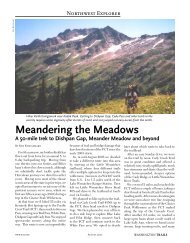
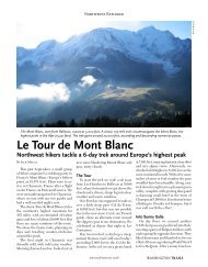
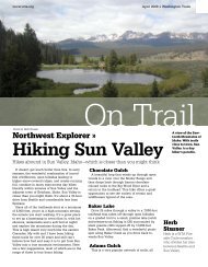
Kim Brown<br />
Opposite page:<br />
Glacier Peak and<br />
fields of false<br />
hellbore from the<br />
Meadow Mountain<br />
<strong>Trail</strong>. This magnificent<br />
hike in the<br />
Darrington Ranger<br />
District has become<br />
an arduous trek<br />
because of washouts<br />
on the White Chuck<br />
River Road.<br />
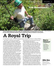
Above: Jim looks<br />
back at a sizeable<br />
washout on the<br />
White Chuck Road.
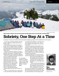
» On <strong>Trail</strong> June 2008 » <strong>Washington</strong> <strong>Trail</strong>s www.wta.org<br />
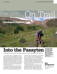
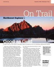
Kim Brown<br />
Jim literally skips<br />
down the trail on<br />
the Meadow Mountain<br />
Traverse. If you<br />
want solitude, now<br />
is the time to explore<br />
the Meadow Mountain<br />
area. Just be<br />
prepared for brushy<br />
trails and washouts<br />
that take an hour or<br />
more to navigate.<br />
<strong>The</strong> new trail is great! It was so new that the<br />
trail crew’s bootprints were still visible in the<br />
tread. <strong>The</strong> trail rounds a ridge and meets the<br />
original trail near the trailhead. This portion is<br />
being rebuilt, but some charming old puncheon<br />
remains there.<br />
We broke out of the trees and entered a lush<br />
meadow that rises to the summit of Circle Peak.<br />
<strong>The</strong> meadow theme of this trip was now firmly<br />
established and would continue until we exited<br />
our ridge hike the next day at Fire Creek, 11<br />
trail miles. We chose not to look for the exposed<br />
route to the true summit and enjoyed the<br />
view from an obvious stopping point.<br />
What views! Glacier Peak, White Chuck,<br />
Pugh, Sloan, Black, Green, Red, Buckindy and<br />
Dome. Plus, Three Fingers, Whitehorse, Baker<br />
and Shuksan. Wow. This is one of the best<br />
summit viewpoints we’ve been to, and it’s only<br />
5,983 feet high. We rested and soaked it in.<br />
<strong>The</strong> trail from Crystal Lake to Circle Peak<br />
and back is 8 miles, approximately 2,700 feet<br />
of gain. We returned to camp, packed up and<br />
relocated to Meadow Lake.<br />
<strong>The</strong> route from Crystal to Meadow has<br />
changed since 2003. It’s choked with downed<br />
trees—big, inconveniently-placed downed trees.<br />
Scrambling the perpendicular-to-slope, reclining<br />
trees was tough, but fun.<br />
Meadow Lake has a marshy shore and is not
www.wta.org June 2008 » <strong>Washington</strong> <strong>Trail</strong>s On <strong>Trail</strong> «<br />
a destination lake, yet it had received heavy use<br />
from campers. It needs this much-needed rest<br />
from humans.<br />
Day 3<br />
Today the hard work really paid off! We hit<br />
the Meadow Mountain Traverse at the site of a<br />
long-gone shelter, and Jim, lighthearted, began<br />
to skip (this was before he found out about the<br />
washout). <strong>The</strong> terrain alternates from meadows<br />
to forest, then meadows again. <strong>The</strong>re are many<br />
ups and downs, but none very steep. This is a<br />
well-constructed trail, and it’s in great shape. It<br />
has seen little use since the 1980s, and likely no<br />
users since the 2003 flood, save for Matt Riggin<br />
of the Darrington district, who hiked it a few<br />
days before we did.<br />
At 5,600 feet, the views return. Pugh, Whitechuck,<br />
<strong>Lost</strong> Creek Ridge, Sloan and an up-close<br />
view of Glacier Peak, over which hovered two<br />
lenticular clouds. Farther along, the forest thins<br />
and the meadows expand. Big meadows, bigger<br />
meadows and then huge meadows! <strong>The</strong>re are<br />
more shades of green here than imaginable.<br />
A view down the White Chuck River Valley<br />
shows a wide mass of brown mud surrounding<br />
a forest of dead trees; this is all that remains of<br />
the Kennedy Hot Springs area.<br />
We switchbacked up the largest meadows of<br />
the day to the high point of our trip, where the<br />
trail touches the ridge at 6,000 feet.<br />
<strong>The</strong> Monte Cristo peaks appear over <strong>Lost</strong><br />
Creek Ridge. Now we could see Baker, Buckindy,<br />
Green, Snowking and Dome. Across the<br />
valley was Lime Ridge, which looks even more<br />
meadow-draped than Meadow Mountain, if<br />
that’s possible.<br />
<strong>The</strong> trail rolls through many basins, crossing<br />
low ridges in between. Fire Mountain and Fire<br />
Creek come into view, named from a fire that<br />
raged through here in 1915. Unfortunately, this<br />
meant the end of our meadowy dreamland, and<br />
we prepared to descend into the trees.<br />
I reminded Jim that it had taken Matt Riggin<br />
about an hour to negotiate the Fire Creek washout<br />
on the White Chuck <strong>Trail</strong>.<br />
“[Expletive deleted]?!” Jim exclaimed.<br />
“Hmmm…” I thought. “Must’ve forgotten to<br />
tell him about that.”<br />
It was getting late, and since we had a logchoked<br />
trail ahead, we had to hustle to our own<br />
navigation of <strong>The</strong> Washout.<br />
We passed by the remains of the old Fire<br />
Chief shelter, and our 2,400-foot descent to the<br />
White Chuck <strong>Trail</strong> began. We entered forest<br />
and said good-bye to an amazing two days of<br />
meadows. This trail is in good shape, too: wellgraded,<br />
with no steep sections. We were glad<br />
the 57 downed trees on this 3.5-mile section<br />
of trail were no problem to get over, under, or<br />
around.<br />
<strong>The</strong>re is no bridge at the first Fire Creek<br />
crossing, but there are several logs that have<br />
been there for years. On the other side of the<br />
creek, the terrain flattens. <strong>The</strong> thick moss is<br />
absolutely incredible here. A second look at<br />
some biomass lumps in the trail revealed they<br />
weren’t just biomass lumps—they were puncheon<br />
bridges. <strong>The</strong> puncheon was so old we<br />
made footprints in it. This section of trail is<br />
rife with frogs and huge mushrooms, two more<br />
themes of this trip.<br />
At about 3,200 feet is a broad, flat area. On<br />
the left, at a sharp, right-turning switchback, is<br />
the faint tread of the long-abandoned Glacier<br />
Way <strong>Trail</strong>.<br />
Finally, we reached the intersection with my<br />
old friend, the White Chuck <strong>Trail</strong>. This once<br />
popular, meticulously maintained trail now lay<br />
silent and ravaged. To see it in this condition is<br />
heartbreaking. We crawled over and under log<br />
after log to the intact bridge over the second<br />
crossing of Fire Creek.<br />
Shortly after, we reached <strong>The</strong> Washout: a<br />
gaping, unstable maw. It was now 6:40 p.m.<br />
We followed the flagged route, up, up, up. We<br />
finally began to traverse, but the slope was<br />
choked with long, girthy downed logs to clamber<br />
around and over. <strong>The</strong> slope is steep, but<br />
there is soft duff that allows purchase. Progress<br />
was painstakingly slow. Jim managed to get<br />
wedged between two trees at one point, and<br />
the sound of our laughter echoed in the lonely<br />
forest. At times the only option was to jump<br />
from one tree branch to another.<br />
It took an hour to traverse <strong>The</strong> Washout.<br />
Later we discovered we had been following<br />
flags for a proposed new trail—it took Matt an<br />
hour because he was rearranging flag locations.<br />
<strong>The</strong>re is no flagged route around <strong>The</strong> Washout.<br />
We took photos of the trailhead register<br />
with names and comments hurriedly scratched<br />
thereon, then set up camp at the little campground<br />
at the quiet trailhead.<br />
Day 4<br />
<strong>The</strong> trailhead is poignant. <strong>The</strong> outhouse,<br />
installed around 2001, is now crowded with<br />
alders. Jim observed that it looks like an ancient<br />
Mayan ruin, and mused that in 10 years, a<br />
bushwhacking person might rediscover it.<br />
On any summer weekend before 2003, this<br />
parking lot would have been full. Today we<br />
were the only people within miles. We slowly<br />
walked the 8.3 miles back to the truck, marveling<br />
at three more easily-negotiated washouts<br />
and the silence of this beautiful, once-busy road.<br />
Of this trip, Jim said the meadows were sublime<br />
and the views were among the best he has<br />
ever had the pleasure of seeing.<br />
Thanks to Jim for agreeing to join me. It’s so<br />
remote here in this new frontier that I would<br />
not have gone alone. I very much wanted to<br />
visit Meadow Mountain—and to walk the White<br />
Chuck <strong>Trail</strong> again.<br />
<strong>The</strong> total trip was 41 miles, 9,900 feet of<br />
elevation gain. <br />
A <strong>Trail</strong><br />
at Risk<br />
<strong>The</strong> Circle<br />
Peak/Meadow<br />
Mountain <strong>Trail</strong><br />
is included in<br />
<strong>Washington</strong> <strong>Trail</strong>s<br />
<strong>Association</strong>’s 2008<br />
list of Endangered<br />
<strong>Trail</strong>s. You can<br />
find out more on<br />
page 14 about<br />
this report on<br />
trails threatened<br />
by flood and fire<br />
damage, lack of<br />
funding and other<br />
problems.<br />
<strong>The</strong> U.S. Forest<br />
Service recently<br />
released a scoping<br />
letter on repair of<br />
the White Chuck<br />
River Road (FR 23)<br />
in May.<br />
You can read<br />
the letter and<br />
learn about the<br />
proposed repairs<br />
online at www.<br />
fs.fed.us/r6/mbs/<br />
projects/ and then<br />
click on “White<br />
Chuck Road 23<br />
Scoping Letter.”