Kshipra Sub Basin - Asian Development Bank
Kshipra Sub Basin - Asian Development Bank
Kshipra Sub Basin - Asian Development Bank

You also want an ePaper? Increase the reach of your titles
YUMPU automatically turns print PDFs into web optimized ePapers that Google loves.
Support to the National Water Mission NAPCC<br />
Appendix 3 <strong>Kshipra</strong> <strong>Sub</strong> <strong>Basin</strong><br />
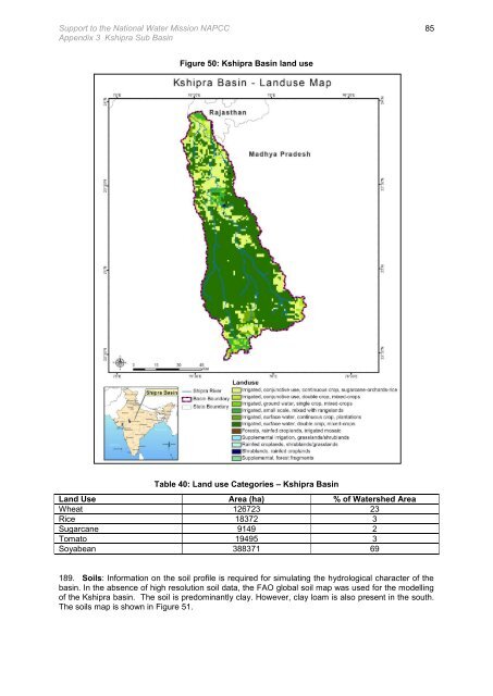
Figure 50: <strong>Kshipra</strong> <strong>Basin</strong> land use<br />
Table 40: Land use Categories – <strong>Kshipra</strong> <strong>Basin</strong><br />
Land Use Area (ha) % of Watershed Area<br />
Wheat 126723 23<br />
Rice 18372 3<br />
Sugarcane 9149 2<br />
Tomato 19495 3<br />
Soyabean 388371 69<br />
189. Soils: Information on the soil profile is required for simulating the hydrological character of the<br />
basin. In the absence of high resolution soil data, the FAO global soil map was used for the modelling<br />
of the <strong>Kshipra</strong> basin. The soil is predominantly clay. However, clay loam is also present in the south.<br />
The soils map is shown in Figure 51.<br />
85