Newlands Parks & Open Space - Quality Assessment Report
Newlands Parks & Open Space - Quality Assessment Report
Newlands Parks & Open Space - Quality Assessment Report

You also want an ePaper? Increase the reach of your titles
YUMPU automatically turns print PDFs into web optimized ePapers that Google loves.
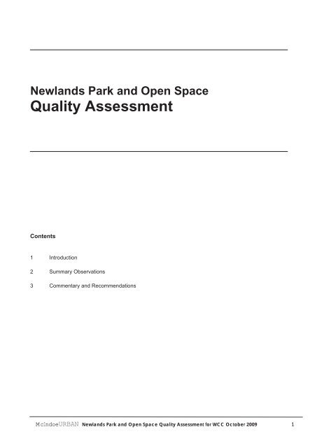
<strong>Newlands</strong> Park and <strong>Open</strong> <strong>Space</strong><br />
<strong>Quality</strong> <strong>Assessment</strong><br />
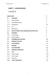
Contents<br />
1 Introduction<br />
2 Summary Observations<br />
3 Commentary and Recommendations<br />
<br />
McIndoeURBAN<strong>Newlands</strong> Park and <strong>Open</strong> <strong>Space</strong> <strong>Quality</strong> <strong>Assessment</strong> for WCC October 2009 1
1 Introduction<br />
<br />
This is a systematic assessment of the quality of the<br />
Council parks and reserves in <strong>Newlands</strong> with rating<br />
against the criteria in a Park and <strong>Open</strong> <strong>Space</strong> <strong>Quality</strong><br />
rating table. The report includes a short commentary<br />
and recommendations for each space. This<br />
assessment does not cover detailed technical issues<br />
such as adequacy of servicing and lighting.<br />
This report is ordered around types of space, with<br />
parks and playgrounds distinct from reserves.<br />
However, several spaces have a dual function, being<br />
both reserves and local parks. These have been<br />
placed in the group which best categorises their<br />
function. This classification does not impact on their<br />
assessment, as the same assessment criteria,<br />
informed by the known functions of each space, have<br />
been applied to all spaces.<br />
The field study was carried out in July and August<br />
2009 by Graeme McIndoe (McIndoeUrban) and<br />
Thomas Hickey (WCC Playgrounds Officer). Naomi<br />
Witham (WCC <strong>Parks</strong> and Gardens GIS Officer) also<br />
assisted.<br />
McIndoeURBAN<strong>Newlands</strong> Park and <strong>Open</strong> <strong>Space</strong> <strong>Quality</strong> <strong>Assessment</strong> for WCC October 2009 2
2 Summary Observations<br />
<strong>Parks</strong> and Playgrounds<br />
2.1 Seven of the 13 local parks reviewed are well-located,<br />
and offer a high level of amenity and a range of<br />
activities. These high quality parks are:<br />
Grenada Village<br />
Salford Street<br />
Kenmore Street<br />
Helston Park Play Area<br />
Brandons Rock<br />
Lyndfield Lane<br />
Cheyne Walk<br />
Nevertheless, some minor modifications relating<br />
variously to signage, access, seating, location of<br />
furniture and equipment, and kickabout areas could be<br />
implemented to further enhance these successful<br />
spaces.<br />
2.2 Several spaces are of notably lesser quality, lacking in<br />
a significant number of ways, but still offering some<br />
amenity. Usually these contribute visual relief and<br />
openness, and sometimes a flat open space within a<br />
hilly neighbourhood. These can continue to contribute<br />
to the local area as long as some significant issues are<br />
addressed, and it is accepted that for various reasons<br />
their contribution is restricted. Public engagement is<br />
needed to better understand their use and value, and<br />
to inform their future function and management. These<br />
spaces include:<br />
Ring Lane<br />
Ceres Street<br />
Jay Street<br />
Lynda Avenue<br />
Spenmoor Street<br />
Jay Street is the only one of these spaces with play<br />
equipment, and none of these are sufficiently centrally<br />
placed for play equipment to be justified.<br />
2.3 One space rates as poor or extremely poor against the<br />
majority of assessment criteria, and its future should be<br />
reconsidered. This is:<br />
Chapman Street<br />
2.4 One space, William Hardgrave, although designated as<br />
a local park and reserve rates relatively poorly as a<br />
reserve. It is small, and undeveloped, but appears<br />
optimally located at the centre of the neighbourhood<br />
and opposite the entrance to a primary school to<br />
become a highly successful local park and play area.<br />
This has good potential and should be investigated<br />
further.<br />
Reserves<br />
2.5 The very large reserves which extend over significant<br />
parts of the periphery of <strong>Newlands</strong>, and along the<br />
harbour-edge escarpment, successfully contribute to a<br />
green belt effect. These have significant visual and<br />
ecological benefits and also offer recreational potential.<br />
This group includes:<br />
<br />
McIndoeURBAN<strong>Newlands</strong> Park and <strong>Open</strong> <strong>Space</strong> <strong>Quality</strong> <strong>Assessment</strong> for WCC October 2009 3
Kentwood Drive<br />
Waihinahina<br />
Seton Nossiter Park<br />
Gilberd Bush<br />
Brandons Rock Walkway<br />
Several of these have well developed walking trails,<br />
and there are opportunities with the newest reserves to<br />
extend those trails.<br />
2.6 Successful links to reserves invite both viewing over<br />
and provide generous connection between the reserve<br />
and public space. Gilberd Bush Reserve and<br />
Kentwood Drive are example of reserves which have<br />
good connections with their local neighbourhoods.<br />
2.7 Trees and planting are often distributed across the<br />
small green areas within reserves, and can prevent<br />
these being used for a kick-about area. An example is<br />
the top area within the otherwise excellent Kentwood<br />
Drive Reserve. While these spaces are not playing<br />
fields, and some visual intricacy and interest is<br />
desirable, elements might be placed for spatial<br />
enclosure, or visual effect while still allowing a<br />
reasonable small kickabout area.<br />
2.8 Other reserves offer a distinctly lesser degree of<br />
amenity, but still contribute in various ways. This group<br />
includes:<br />
79 Kentwood Drive<br />
Glanmire Road<br />
White Pine Avenue<br />
Henly Estate<br />
William Hardgrave<br />
2.9 Four small reserves provided in new subdivisions offer<br />
little or nil amenity and are of extremely poor quality:<br />
Tamworth Crescent<br />
Dungarvan Road (2 reserves)<br />
Sheridan Terrace<br />
These areas are the only open spaces in the<br />
subdivisions, often occupy residual space that would<br />
not be suitable for any other activity, and are<br />
inaccessible. They fail to meet the objectives of<br />
Council’s Subdivision Design Guide. This calls into<br />
question the process which approved their designation.<br />
Sports Fields<br />
2.10 The highest-rated sports field, <strong>Newlands</strong> Park is<br />
attractive, in a good state of repair and offers good<br />
surfaces, but critically, it is both suitable for and<br />
welcomes a range of uses.<br />
2.11 Mark Avenue and Pinkerton Park (categorised in this<br />
study as a sports field given its primary use) are also of<br />
generally high quality, even though there are issues to<br />
address with each which could lead to improve these.<br />
2.12 Helston Park is the least successful sports field. It is<br />
characterised by mono-functionality, a location that<br />
does not invite a range of users, a poor entrance<br />
experience, and relatively drab, ill-maintained facilities.<br />
McIndoeURBAN<strong>Newlands</strong> Park and <strong>Open</strong> <strong>Space</strong> <strong>Quality</strong> <strong>Assessment</strong> for WCC October 2009 4
3 Commentary and Recommendations<br />
Grenada Village Play Area<br />
Primary role and functions<br />
Local park and play area<br />
Summary assessment<br />
An exemplary local park, very well located at the centre of<br />
Grenada Village.<br />
Recommendations<br />
Work with Grenada Village Community Association to<br />
maximise use of the tennis courts.<br />
Relation to context<br />
Located at an intersection on the main route through the<br />
neighbourhood, this park is both visible and readily accessible.<br />
Located at a bus stop and with good parking adjacent.<br />
Image and ambience<br />
Swathe of grass and trees at the street edge create a pleasing<br />
first impression.<br />
Benefits from mature trees, landscaping, furniture, equipment<br />
and clubrooms all being attractive and in a good state of repair.<br />
Function, activity and occupation<br />
Well-overlooked by houses on all sides, this is likely to both feel<br />
safe and be safe.<br />
Provides high quality play equipment, with several places to sit,<br />
including under trees next to the play area.<br />
Sloping site precludes use for a kick-about area, however<br />
active recreation is provided for with the tennis courts. However<br />
these are not open to the general public. They appear to be for<br />
use of members only, so recreational benefits of this surface<br />
remains restricted.<br />
Environmental conditions<br />
Good sun, but exposed to northerly winds.<br />
<br />
All parts of the park and play area are prominent in<br />
view from adjacent houses.<br />
High quality play equipment provides multiple<br />
opportunities for challenging play<br />
Mature trees provide shelter, shade and spatial<br />
definition between the tennis courts and play area<br />
Clubrooms in very good condition next to tennis courts<br />
with moss and weeds beginning to grow through<br />
McIndoeURBAN<strong>Newlands</strong> Park and <strong>Open</strong> <strong>Space</strong> <strong>Quality</strong> <strong>Assessment</strong> for WCC October 2009 5
Salford Street Play Area<br />
Primary role and functions<br />
Local park and play area<br />
Summary assessment<br />
A very successful, highly visible park which offers a good range<br />
of recreational opportunities.<br />
Recommendations<br />
Investigate potential to develop the grassed amphitheatre for<br />
active play by slightly levelling the grassed surface at its base<br />
and providing a larger and more effective netting back stop.<br />
Relation to context<br />
Centrally located and highly accessible.<br />
Image and ambience<br />
Sweeping grassed contours and mature trees framing a view<br />
back out over the harbour assist in making this a very attractive<br />
park.<br />
Function, activity and occupation<br />
Well-overlooked from the street and from surrounding houses,<br />
promoting a strong sense of safety.<br />
Has a number of spaces on different levels that provide a range<br />
of settings for different groups and types of play.<br />
Environmental conditions<br />
While in a south facing valley, receives good sun, but likely to<br />
be exposed to southerly winds.<br />
Trees provide some wind shelter and shade.<br />
<br />
Play area provides a good range of equipment and<br />
has good informal surveillance from both adjacent<br />
houses and the street<br />
Park offers spectacular view to the south, and<br />
amphitheatre-like contours offer potential for active<br />
play<br />
Footpath winds along edge of park<br />
McIndoeURBAN<strong>Newlands</strong> Park and <strong>Open</strong> <strong>Space</strong> <strong>Quality</strong> <strong>Assessment</strong> for WCC October 2009 6
Kenmore Street Play Area<br />
Primary role and functions<br />
Local park and play area<br />
Summary assessment<br />
An attractive small local park and play area for young children.<br />
Recommendations<br />
Install signage to indicate the pedestrian link between Kenmore<br />
Street and Longcroft Terrace.<br />
Provide for wheelchair access at one of the two entry points.<br />
Relation to context<br />
Centrally located around 100 metres from the <strong>Newlands</strong> town<br />
centre, this is also on main routes to the town centre, and also<br />
can be accessed from Longcroft Terrace.<br />
The park can be accessed by a range of modes, with parking<br />
provided and bus routes passing close by.<br />
Image and ambience<br />
Park, vegetation and equipment are all in good condition, with<br />
the exception of the garden areas around the entrances where<br />
planting appears to have been replaced with bark chips. The<br />
high fence along the edge of the Plunket Room however<br />
creates an apparently unnecessary blank edge and precludes<br />
informal surveillance in both directions across the shared<br />
boundary.<br />
Function, activity and occupation<br />
Small and providing a playground suitable for young children.<br />
This is appropriate, complementing the immediately adjacent<br />
<strong>Newlands</strong> Plunket rooms.<br />
Trails through the small area of trees at the boundary show that<br />
this area is also used for children’s play, and it complements<br />
the formal playground.<br />
While there is very good access, neither of the two entry points<br />
allow for wheelchair access. This could be easily remedied.<br />
Environmental conditions<br />
Trees along the northern (Horokiwi Road West)and western<br />
boundary and location at a valley floor mean that this is<br />
sheltered from prevailing winds. Despite this enclosure, it still<br />
receives good mid-winter sun.<br />
<br />
Kenmore Street Play Area is well defined and<br />
sheltered by contours and mature planting, but<br />
remains open to the adjacent street<br />
Connection to Longcroft Terrace up to the right, with<br />
Plunket Rooms also at right.<br />
Carparking at entry<br />
McIndoeURBAN<strong>Newlands</strong> Park and <strong>Open</strong> <strong>Space</strong> <strong>Quality</strong> <strong>Assessment</strong> for WCC October 2009 7
Helston Park Play Area<br />
Primary role and functions<br />
Local park and play area<br />
Summary assessment<br />
A well situated, safe and attractive local park and playground<br />
with a very good range of equipment.<br />
Recommendations<br />
Install a third entry at the north-western corner of the park. This<br />
would be from Helston Road, connecting to the existing<br />
footpath and should provide for wheelchair access.<br />
Relation to context<br />
Prominent in view on a main thoroughfare, and located at the<br />
main entrance to Helston Park, this is central and highly visible.<br />
Image and ambience<br />
High quality play equipment in a good state of repair and some<br />
mature trees contribute to a pleasant environment.<br />
Function, activity and occupation<br />
Provides play opportunities for a range of ages, and includes<br />
half-court basketball for active play.<br />
Environmental conditions<br />
Good sun exposure.<br />
<br />
Prominently located at the edge of Helston Road, this<br />
provides play opportunities for a range of ages<br />
Challenging play equipment<br />
Edge to Helston Road is well-fenced, but lacks an<br />
entrance for users approaching from the north<br />
Proximity to Helston Park allows for shared use of car<br />
parking (across road at rear)<br />
McIndoeURBAN<strong>Newlands</strong> Park and <strong>Open</strong> <strong>Space</strong> <strong>Quality</strong> <strong>Assessment</strong> for WCC October 2009 8
Brandons Rock and Edgecombe Street Play Area<br />
Primary role and functions<br />
Local park and play area<br />
Summary assessment<br />
Small local park, which is highly memorable due to its unique<br />
location at the top of the escarpment, spectacular views and<br />
unique landform at its southern edge.<br />
Recommendations<br />
Consider how proposed replacement play equipment can be<br />
located to both provide for a small kick around area, and be<br />
sufficiently separated from the road for safety.<br />
Consider placement of a kerb crossing at southern end to<br />
assist entry into the park with buggies, prams and bicycles.<br />
Relation to context<br />
Highly accessible from the street.<br />
Image and ambience<br />
Highly memorable due to unique configuration and views.<br />
Function, activity and occupation<br />
Small, but open to view towards the street and community for<br />
very good informal surveillance.<br />
Combination of sloping grass, flat area, tree for climbing and<br />
proposed replacement play equipment makes this a very<br />
attractive small local park offering lots of play opportunities.<br />
Environmental conditions<br />
Sunny and in this potentially highly exposed ridge top location,<br />
reasonably sheltered as well as spatially defined by land form<br />
and trees.<br />
<br />
Southern end of playground is sheltered and enclosed<br />
by topography and mature trees<br />
Northern end opens to harbour views<br />
McIndoeURBAN<strong>Newlands</strong> Park and <strong>Open</strong> <strong>Space</strong> <strong>Quality</strong> <strong>Assessment</strong> for WCC October 2009 9
Lyndfield Lane Play Area<br />
Primary role and functions<br />
Local park and play area<br />
Summary assessment<br />
This is a very large, high quality park. Several small<br />
enhancements could lead to it being exemplary.<br />
Recommendations<br />
Locate new play equipment scheduled to be installed in<br />
October 2011 off to one side to allow for an excellent<br />
kickaround area.<br />
Provide all weather access (a path) to the new play equipment.<br />
Enhance seating opportunity at the lower part of the park close<br />
to the playground and kick-around area, considering<br />
particularly informal seating opportunities.<br />
Provide signage at both Lyndfield Lane and Black Rock Road<br />
to indicate pedestrian access between these streets.<br />
Provide a second connection to the lawn area at the top of the<br />
park to encourage use of this underutilised area. This would be<br />
short (in the order of 20 metres), would go along the contours<br />
through the bush area and should connect to the existing<br />
through-site paved path to provide for a circuit walk.<br />
Address removal of wind-blown rubbish.<br />
Relation to context<br />
The park is highly visible and open to Lyndfield Road with<br />
multiple entrances. However, while there is access from Black<br />
Rock Road, this is not obvious.<br />
Provides linkage between Black Rock Road and Lyndfield<br />
Lane, however this linkage is not developed or signposted.<br />
Offers potential to act as an important connector for<br />
pedestrians in an area where steep and complex contours and<br />
consequent lack of interconnection in the roading layout mean<br />
that connections are few. Link between Lyndfield Lane and<br />
Black Rock Road, crossing this very large block.<br />
Image and ambience<br />
Attractive area characterised by manageable changes in level,<br />
mature trees and bush.<br />
The space is compromised by apparently wind-blown rubbish<br />
that has collected along the path at the base of the bush by the<br />
lower lawn area.<br />
Function, activity and occupation<br />
The park provides for multiple functions – play areas, kickaround,<br />
tennis and hockey.<br />
An elevated lawn area behind the bush to the north of the<br />
tennis courts is defined by trees and bush, and offers<br />
spectacular views in several directions including to the harbour.<br />
It is however not visible, and accessible only by one path.<br />
The lower grassed area has excellent natural surveillance as it<br />
is overlooked from neighbouring houses.<br />
Environmental conditions<br />
Sunny and sheltered.<br />
<br />
Play equipment set within a large, sunny and<br />
sheltered, green open space. Neighbouring houses<br />
offer good informal surveillance<br />
A large, sunny, but currently relatively inaccessible<br />
lawn area at the top of the park offers views south to<br />
the harbour and central city<br />
McIndoeURBAN<strong>Newlands</strong> Park and <strong>Open</strong> <strong>Space</strong> <strong>Quality</strong> <strong>Assessment</strong> for WCC October 2009 10
Cheyne Walk Play Area<br />
Primary role and functions<br />
Local park and playground<br />
Summary assessment<br />
This is a very well-located, highly accessible, sheltered and<br />
sunny local park. It is however compromised by a large mound<br />
of grassed earth at its centre which, while providing some<br />
opportunities for play, splits the large green area into two<br />
smaller areas, neither really suitable for kick-about, and which<br />
screens views into the park. This could readily be modified.<br />
Recommendations<br />
Remove mound from centre of park to provide a large kickabout<br />
area, potentially creating elevation elsewhere at the edge<br />
of the park.<br />
Relation to context<br />
Very well located on the top of a broad ridge with easy flat<br />
access along and from surrounding streets.<br />
This is highly accessible to the local neighbourhood, with<br />
multiple access points including from Cheyne Walk and via a<br />
grassed lane, from Somes Crescent close to its intersection<br />
with Bayfield Drive.<br />
Image and ambience<br />
Boundary trees and a large, well maintained grassed area<br />
create a pleasant ambience.<br />
Furniture and play equipment is old, and while looking ‘tired’ is<br />
in good repair.<br />
Function, activity and occupation<br />
Large, with a good degree of natural surveillance this park<br />
offers considerable recreational potential. However, its use and<br />
safety is compromised by the large earth mound at its centre<br />
which precludes what would otherwise be a large kick-about<br />
area, and screens the rear of the park from view from the road.<br />
At the same time this mound provides scope for some types of<br />
children’s play. Contouring might be retained but in a different<br />
location (and probably necessarily to a lesser extent) at the<br />
edge of the park.<br />
Environmental conditions<br />
Sheltered and sunny.<br />
<br />
The large, sunny sheltered and flat grassed area<br />
subdivided by a grassed mound<br />
Second means of access into the park from Somes<br />
Crescent<br />
McIndoeURBAN<strong>Newlands</strong> Park and <strong>Open</strong> <strong>Space</strong> <strong>Quality</strong> <strong>Assessment</strong> for WCC October 2009 11
Ring Lane Park<br />
Primary role and functions<br />
Local park<br />
Summary assessment<br />
The primary benefit of this space is visual, providing a sense of<br />
green openness.<br />
Recommendations<br />
Tidy up existing low level planting on the northern bank and<br />
potentially plant some taller trees here to partially screen the<br />
northern boundary fence, and enhance the primary benefit of<br />
this space which is visual amenity.<br />
Install subsoil drainage to allow use of the grass surface during<br />
winter.<br />
Relation to context<br />
Location directly across the road from <strong>Newlands</strong> College<br />
places this reserve at the edge of the residential area.<br />
Proximity of high quality fields at the College is likely to limit the<br />
use of this space for kick-about.<br />
Image and ambience<br />
This space is undeveloped and residual with the elevated<br />
northern edge being prominent in view, and dominated by the<br />
rear of a boundary fence.<br />
Very well overlooked and likely to be very safe.<br />
Function, activity and occupation<br />
This park provides a narrow flat area however edges which<br />
drop away are likely to limit potential for kick-about.<br />
Turf, while appearing in good condition, is extremely wet and<br />
soft underfoot.<br />
The recreational potential of this park is currently limited, and<br />
its location at the edge of the residential area makes it difficult<br />
to justify locating play equipment here.<br />
<br />
The park occupies an elevated corner site opposite<br />
<strong>Newlands</strong> College<br />
Very good natural surveillance from adjacent houses<br />
McIndoeURBAN<strong>Newlands</strong> Park and <strong>Open</strong> <strong>Space</strong> <strong>Quality</strong> <strong>Assessment</strong> for WCC October 2009 12
Ceres Street Park<br />
Primary role and functions<br />
Local park<br />
Summary assessment<br />
Provides visual amenity for immediate neighbours and some<br />
recreational potential, which could be enhanced by formalising<br />
and signing an existing accessway.<br />
Recommendations<br />
Strengthen and signpost existing connection to and from<br />
Cheltenham Terrace in order to provide for a recreational<br />
walking loop, and enlarge the neighbourhood catchment of the<br />
park.<br />
Provide signage describing links through the park at both<br />
entrances.<br />
Relation to context<br />
Located at the south-west fringe of <strong>Newlands</strong> at the end of a<br />
cul-de-sac, this park nevertheless is connected with an<br />
undeveloped and unsigned access-way to the wider<br />
neighbourhood.<br />
Image and ambience<br />
These edges are typically (but not always) well maintained,<br />
giving a pleasing sense of local custodianship and safety. Most<br />
neighbours have not erected fences, instead installing<br />
generally high quality garden edges.<br />
Existing and recent planting along the northern edge<br />
contributes to visual amenity.<br />
Function, activity and occupation<br />
This is a reasonably steeply sloping grassed area with some<br />
planting along its northern edge. While not suitable for kickabout,<br />
it may provide for some types of active play. It does<br />
provide visual amenity for immediate neighbours.<br />
Potential to contribute to the neighbourhood network of<br />
walkways is not fully exploited. An existing accessway is<br />
unsigned and the path it provides is undeveloped.<br />
Environmental conditions<br />
Sloping directly to the north-west this grassed area receives full<br />
afternoon sun but is also fully exposed to north-westerly winds.<br />
<br />
Messy storage at the boundary of adjacent houses<br />
which nevertheless benefit greatly from views over the<br />
park<br />
Potential for existing accessway which links with<br />
Cheltenham Terrace to be enhanced to provide a<br />
circuit through the park<br />
McIndoeURBAN<strong>Newlands</strong> Park and <strong>Open</strong> <strong>Space</strong> <strong>Quality</strong> <strong>Assessment</strong> for WCC October 2009 13
Jay Street Park<br />
Primary role and functions<br />
Local park<br />
Summary assessment<br />
A currently overly-secluded flat green open space not well<br />
located at the margins of the residential area. This may<br />
continue to contribute limited recreational benefits following<br />
removal of play equipment and strategic thinning of edge<br />
planting.<br />
Recommendations<br />
Consult on future needs and options for this park space.<br />
Consider selective removal or trimming of some boundary<br />
planting to open the park into view from adjoining houses<br />
(including from houses on Jay Street), while still maintaining<br />
strong planting for shelter and spatial definition.<br />
Relation to context<br />
Located at the very edge of the residential area and therefore<br />
accessed only from one side, this also has very poor physical<br />
and visual connections to other places. The park is not visible<br />
from Jay Street.<br />
Image and ambience<br />
Boundary planting and large flat area of grass creates an<br />
attractive sense of enclosure. However, the seclusion means<br />
that caregivers with young children are unlikely to find this<br />
attractive.<br />
Function, activity and occupation<br />
Lack of connection with surroundings, and lack of informal<br />
surveillance makes this of limited value as a play area.<br />
While old, steel tube play equipment and a basketball hoop are<br />
provided, this is dispersed across the grass and apparently<br />
relatively unused.<br />
One primary function appears to be convenient means of<br />
access to the lower playing fields of <strong>Newlands</strong> College from the<br />
residential areas to the north-west. This access should be<br />
maintained.<br />
Environmental conditions<br />
Very well sheltered due to enclosing trees.<br />
Benefits from potentially good sun exposure, except that when<br />
sun is low, the surrounding trees and planting cast shadows<br />
over much of the park.<br />
<br />
Park provides a pedestrian link from Jay Street<br />
through to the rear of <strong>Newlands</strong> College<br />
A large flat green open space is provided, but this is<br />
not well overlooked<br />
Dispersed play equipment is outdated and uninviting<br />
McIndoeURBAN<strong>Newlands</strong> Park and <strong>Open</strong> <strong>Space</strong> <strong>Quality</strong> <strong>Assessment</strong> for WCC October 2009 14
Lynda Avenue Park<br />
Primary role and functions<br />
Local park<br />
Summary assessment<br />
Provides a pleasing outlook and open space for local residents,<br />
but offers limited recreational amenity.<br />
Recommendations<br />
Retain as a local open green area<br />
Consider placing a park bench in a sunny location at the edge<br />
of the park.<br />
Relation to context<br />
Located close to the western edge of <strong>Newlands</strong>, this is visible<br />
from and readily accessible to a relatively small catchment.<br />
Image and ambience<br />
Has good quality edge planting.<br />
<strong>Open</strong> to the street and overlooked by adjacent houses, this<br />
provides a sense of safety.<br />
Function, activity and occupation<br />
Too small and unevenly contoured to allow useful kick-about<br />
space, and lacking play equipment or furniture, this space does<br />
not offer significant recreational benefit.<br />
Environmental conditions<br />
Sunny and open to the north.<br />
<br />
Planting around the edge provides a pleasant green<br />
enclave.<br />
Water is ponding on a depression of this area which<br />
was once a tip site<br />
McIndoeURBAN<strong>Newlands</strong> Park and <strong>Open</strong> <strong>Space</strong> <strong>Quality</strong> <strong>Assessment</strong> for WCC October 2009 15
Spenmoor Street Reserve<br />
Primary role and functions<br />
Local park and dog exercise area<br />
Summary assessment<br />
While this appears to usefully serve the <strong>Newlands</strong> Scout Hall<br />
and potentially dog-owners, it is very poor when tested against<br />
the criteria applicable to local parks and relative to other local<br />
parks in <strong>Newlands</strong>. It is limited in functionality and benefit due<br />
to its relative inaccessibility, lack of informal surveillance and<br />
lack of flat area.<br />
Recommendations<br />
Given limited use and utility this should not be regarded as a<br />
local park, rather as a reserve with important but limited<br />
functionality which complements the nearby Lyndfield Lane<br />
local park.<br />
Consider potential to formalise a well signed, and safe link<br />
through the park. This would reduce walking distance from the<br />
entry of the new residential subdivision to the <strong>Newlands</strong> Road<br />
bus stop from the 725 metres required if walking along the<br />
street to 240 metres.<br />
Relation to context<br />
Located between Spenmoor Street and <strong>Newlands</strong> Road, and<br />
providing a not very well defined link between the two, this park<br />
could be developed with a formalised pedestrian path to give<br />
access from the new subdivision above to the bus stops on<br />
<strong>Newlands</strong> Road. A consideration in formalising a link would be<br />
whether there is sufficient natural surveillance to ensure it is<br />
acceptably safe.<br />
Image and ambience<br />
Poor image due to scruffy bush and trees around the edges of<br />
the space, and signs of disorder. At the time of site visit, there<br />
was a dumped stolen car at the bottom of the slope.<br />
Function, activity and occupation<br />
The steeply sloping lawn may provide for some types of active<br />
play by users of the <strong>Newlands</strong> Scout Hall at the Spenmoor<br />
Street entrance.<br />
Poor natural surveillance, with a few backs of lots edging the<br />
lower part of the park.<br />
The entrance from <strong>Newlands</strong> Road up through the bush is<br />
informal, and unlikely to be inviting. With lack of visibility of<br />
destination and lack of informal surveillance at edges, use is<br />
likely to be restricted to people who know the connection, and<br />
are confident. The path and bush area would however provide<br />
for active play for older children.<br />
While the park does connect <strong>Newlands</strong> Road and Spenmoor<br />
Street, the lack of a continuous pathway through will restrict its<br />
use as a pedestrian linkage, particularly when the sloping grass<br />
is wet.<br />
Environmental conditions<br />
Sunny, but potentially exposed to north-westerly winds.<br />
<br />
View from the footpath on Spenmoor Street over<br />
Spenmoor Street Park.<br />
Entrance from <strong>Newlands</strong> Road<br />
View up towards the scout hall and top of the park<br />
from the west<br />
McIndoeURBAN<strong>Newlands</strong> Park and <strong>Open</strong> <strong>Space</strong> <strong>Quality</strong> <strong>Assessment</strong> for WCC October 2009 16
Chapman Street Park<br />
Primary role and functions<br />
Local park<br />
Summary assessment<br />
A pair of small green fragments that offer no apparent<br />
neighbourhood benefit other than a sense of openness for a<br />
very few houses directly adjacent and across the road.<br />
Recommendations<br />
Consult on deleting the larger area from parks holdings.<br />
Retain and maintain small area (with transformer).<br />
Relation to context<br />
Located at the edge of an access-way linking down to Burgess<br />
Road and beyond towards Helston Park.<br />
Reasonably well-located at the centre of a residential area, but<br />
elevated above much of that area.<br />
Image and ambience<br />
A simple swathe of green grass, notable only for the view it<br />
opens out to the north from Chapman Street and nearby<br />
houses.<br />
Function, activity and occupation<br />
Largest grassed area is small and too sloping for useful<br />
kickabout.<br />
Small area accommodates a transformer, but also signals link<br />
down to Burgess Road<br />
Environmental conditions<br />
Sunny but, at the top of a north-facing escarpment, both highly<br />
exposed to northerly winds and lacking shelter.<br />
<br />
<br />
<br />
<br />
<br />
<br />
<br />
Park is split by an intervening house, and spaces are<br />
undeveloped, offering little visual amenity and no<br />
recreational potential<br />
Transformer dominates the westernmost segment<br />
Steps down to Burgess Road at edge of westernmost<br />
part of park<br />
McIndoeURBAN<strong>Newlands</strong> Park and <strong>Open</strong> <strong>Space</strong> <strong>Quality</strong> <strong>Assessment</strong> for WCC October 2009 17
Kentwood Drive Reserve<br />
Primary role and functions<br />
Local park and reserve<br />
Summary assessment<br />
Very high quality local park and reserve, located at the centre<br />
of the neighbourhood so is highly accessible and also offers<br />
significant potential to function as a well-located playground.<br />
Recommendations<br />
Locate the playground scheduled to be installed in 2010 close<br />
to and accessed from the lower main entry.<br />
Drain lower grassed area to allow this to function as a kickabout<br />
area.<br />
Remove some of the shrubs/trees at the centre of the upper<br />
entry, replacing with planting at the edges to allow for informal<br />
kick-about.<br />
Consider developing a walkway linking the upper and lower<br />
grassed areas to allow this to function as part of a recreational<br />
walking circuit.<br />
Install signs for wayfinding, and interpretation (related to the<br />
stream regeneration).<br />
Relation to context<br />
Located at the centre of a developing residential area where<br />
there are no recreational facilities, this offers potential for a<br />
local playground.<br />
Offers multiple, wide and open connections to the<br />
neighbourhood, and is accessible by a range of modes of<br />
transport.<br />
There is clear evidence of community ownership and<br />
involvement in the re-planting related to the stream.<br />
Image and ambience<br />
Comprises attractive regenerating bush and planting including<br />
a stream, and generous open grassed areas, compromised to<br />
only a minor extent by the overhead high-voltage power lines.<br />
Function, activity and occupation<br />
Wide open entrances are all associated with reasonably flat<br />
grassed areas of varying sizes. These provide for local<br />
recreational potential.<br />
Lower grassed area is wet and requires drainage.<br />
Kick-about potential of the upper entrance space is somewhat<br />
limited by placement of trees/shrubs through the centre of the<br />
space.<br />
Reserve lacks identifying signs.<br />
Environmental conditions<br />
<strong>Open</strong>s to the north/north-west so is very sunny, however is also<br />
exposed to the wind.<br />
<br />
Large open space at upper entry to Kentwood Drive<br />
Reserve<br />
Reserve opens to the north, with bus stop, parking and<br />
access to a large green open space<br />
Large green open space with reserve extending up<br />
valley to the south. Potential kick-about, but needs<br />
drainage<br />
McIndoeURBAN<strong>Newlands</strong> Park and <strong>Open</strong> <strong>Space</strong> <strong>Quality</strong> <strong>Assessment</strong> for WCC October 2009 18
Waihinahina Reserve (in memory of Dennis Duggan)<br />
Primary role and functions<br />
Reserve and dog exercise area<br />
Summary assessment<br />
A visually attractive reserve space, memorable in its spatial<br />
qualities and location as a plateau above the harbour, and<br />
satisfies an important recreational function.<br />
Recommendations<br />
Identify and install features to enhance this as a destination<br />
dog exercise park.<br />
Repair the potholes that are appearing in the car park, and<br />
remove the graffiti from the entry sign.<br />
There are some areas of standing water on the turf. These may<br />
or may not be problematic (and were observed to be attractive<br />
to frolicking dogs), however if a permanent feature, may be<br />
best drained and filled, or developed as wetlands.<br />
Relation to context<br />
Mainly comprising a large bush reserve, this contributes to the<br />
green belt effect that is being developed along the harbouredge<br />
escarpment.<br />
Location at the periphery of <strong>Newlands</strong>, with the flat grassed<br />
area 800 metres from Woodridge Drive and requiring a climb of<br />
10 metres then a drop of 35 metres, this will for most people be<br />
accessible only by car.<br />
Image and ambience<br />
An extraordinarily spectacular site with views down the Petone<br />
beach and across the harbour, Combination of steep bush-clad<br />
hills give strong spatial definition which in combination with the<br />
very large flat green open space in an unexpected hillside<br />
location, gives a memorable sense of place.<br />
Good state of repair indicate that this area is well respected.<br />
A variety of spaces and paths allows for multiple types of use.<br />
Function, activity and occupation<br />
Informal observation of use indicates this is well-used.<br />
This has been identified as a ‘destination dog park’ in the<br />
current Dog Policy Review<br />
While primarily a dog-exercise area, the spectacular setting<br />
and views obtained from this reserve also make it an attractive<br />
recreational destination.<br />
A large and well-landscaped carpark is provided to cater for the<br />
primary mode of access.<br />
<br />
Entrance view and approach to Waihinahina Reserve<br />
Large open area showing typical use and spectacular<br />
setting<br />
Pleasant, sunny and sheltered secondary space to the<br />
west of the parking area<br />
McIndoeURBAN<strong>Newlands</strong> Park and <strong>Open</strong> <strong>Space</strong> <strong>Quality</strong> <strong>Assessment</strong> for WCC October 2009 19
Seton Nossiter Park<br />
Primary role and functions<br />
Reserve and dog exercise area<br />
Summary assessment<br />
A very large reserve area that contributes significantly to the<br />
green network of <strong>Newlands</strong>, and provides good recreational<br />
potential with a number of spaces and walkways.<br />
Recommendations<br />
Consider quality of edge planting along Mark Avenue,<br />
encouraging replacement of gorse and weeds with native<br />
shrubs and trees, and for providing a view down into the valley.<br />
Upgrade faded sign at Bushland Road entrance.<br />
Relation to context<br />
Makes a significant contribution to the developing network of<br />
reserves around the perimeter of <strong>Newlands</strong>.<br />
This makes positive use of the valley between <strong>Newlands</strong> and<br />
Grenada North and provides for recreational walking.<br />
Due to the open space of the nearby <strong>Newlands</strong> College playing<br />
fields and associated heavy planting, contributes to a very large<br />
green open area in this part of <strong>Newlands</strong>.<br />
This reserve provides an attractive outlook from neighbouring<br />
houses, in particular being open to Colchester Crescent. It also<br />
has physical connection from its southern end at two points<br />
(Fernwood Court and Colchester Crescent).<br />
Image and ambience<br />
Planting is relatively mixed, with gorse dominant on northfacing<br />
valley walls, and typically regenerating bush elsewhere.<br />
Entrances are well-signed and generally attractive.<br />
The sunny valley with walls clad in a consistent carpet of<br />
regenerating bush that extends north from Colchester Crescent<br />
is very attractive.<br />
Function, activity and occupation<br />
Provides a network of trails for walking and dog exercise as<br />
well as a series of flat green open spaces.<br />
Environmental conditions<br />
Generally sunny, given orientation to the north of several<br />
valleys.<br />
Parts of the valley with an east-west orientation are likely to be<br />
reasonably sheltered from prevailing winds.<br />
<br />
Entry signposting (with faded graphics)at Bushland<br />
Grove entrance<br />
Bushland Grove entrance is wide, sunny and<br />
welcoming<br />
Scout hall with kick-about area and car parking at<br />
northern entry from Mark Avenue<br />
View from Mark Avenue showing the grassed areas<br />
and track along the valley floor<br />
McIndoeURBAN<strong>Newlands</strong> Park and <strong>Open</strong> <strong>Space</strong> <strong>Quality</strong> <strong>Assessment</strong> for WCC October 2009 20
Mark Avenue edge is relatively poor<br />
The southern end of Seton Nossiter Park is a very<br />
large, heavily planted valley<br />
The two walkway entries at the southern end – near<br />
left (from Fernwood Court) and distant mid-upper left<br />
from Colchester Crescent<br />
McIndoeURBAN<strong>Newlands</strong> Park and <strong>Open</strong> <strong>Space</strong> <strong>Quality</strong> <strong>Assessment</strong> for WCC October 2009 21
Gilberd Bush Reserve<br />
Primary role and functions<br />
Reserve<br />
Summary assessment<br />
This attractive swathe of regenerating bush extends the green<br />
belt, is large enough to offer ecological benefits, and provides<br />
for recreational use with its network of well-signed walking<br />
tracks.<br />
Recommendations<br />
Examine possible encroachment at the southernmost entry off<br />
Fernhaven Grove.<br />
Relation to context<br />
Well-connected to adjoin streets at three points.<br />
Image and ambience<br />
Well-maintained, wide and open connections to adjoining<br />
streets allow the park to be enjoyed by street users as well as<br />
residents who look across into the reserve.<br />
Function, activity and occupation<br />
The reserve is large enough to have an important ecological<br />
function, provides an attractive outlook for adjoining residential<br />
areas and recreational walkways.<br />
Wide and open connections and well-maintained pathways<br />
allow walkway users a view into the reserve before entry.<br />
Entry points are well signposted.<br />
Environmental conditions<br />
Largely comprising an south-east facing valley this reserve,<br />
while opening to the harbour, is reasonably sheltered.<br />
<br />
Overview of the Gilberd Bush Reserve, with houses<br />
along its west edge<br />
Paths are visible and well sign-posted<br />
McIndoeURBAN<strong>Newlands</strong> Park and <strong>Open</strong> <strong>Space</strong> <strong>Quality</strong> <strong>Assessment</strong> for WCC October 2009 22
Brandon’s Rock Walkway<br />
Primary role and functions<br />
Public walkway<br />
Summary assessment<br />
A successful recreational walkway with a valuable<br />
neighbourhood connection function.<br />
Recommendations<br />
Consider either expanding the extent of planting at walkway<br />
entrances such as this to relate to the scale of the walkway, or<br />
deleting such planting.<br />
Relation to context<br />
While providing for recreational walking, this also provides<br />
excellent neighbourhood connection.<br />
Brandon’s Rock is an historic local landmark, now made more<br />
accessible to the neighbourhood.<br />
Image and ambience<br />
This gains its character from its exposed ridge-top location and<br />
spectacular views afforded across the harbour.<br />
The small area of planting at the southern entry appears<br />
domestic in scale, and fragmentary.<br />
Function, activity and occupation<br />
Excellent natural surveillance from neighbouring houses is<br />
possible over most of the walkway.<br />
Environmental conditions<br />
Highly exposed to both prevailing winds, this is a recreational<br />
walkway where users can experience the extremes of<br />
Wellington weather. This, in combination with spectacular<br />
views, will make for a memorable experience.<br />
<br />
Western entrance<br />
Walkway follows the ridge, offering spectacular views<br />
over the harbour and is overlooked by adjoining<br />
houses<br />
McIndoeURBAN<strong>Newlands</strong> Park and <strong>Open</strong> <strong>Space</strong> <strong>Quality</strong> <strong>Assessment</strong> for WCC October 2009 23
79 Kentwood Drive Reserve<br />
Primary role and functions<br />
Reserve<br />
Summary assessment<br />
While comprising residual and inaccessible land, it is very close<br />
to Kentwood Drive reserve, and therefore contributes to the<br />
continuity of reserves in <strong>Newlands</strong> as well as visual amenity for<br />
neighbouring residents.<br />
Recommendations<br />
Consider addressing informal encroachment.<br />
Relation to context<br />
Contributes in a minor but positive way to the developing<br />
network of reserves that mark the periphery of <strong>Newlands</strong>.<br />
Image and ambience<br />
Characterised by broken topography with some regenerating<br />
bush, but is largely gorse covered. Nevertheless, this provides<br />
some visual amenity for residents but is compromised to an<br />
extent by the overhead high-voltage power lines.<br />
Function, activity and occupation<br />
Except for the lawn area which joins to Kentwood Drive, this is<br />
physically inaccessible to the public.<br />
There are signs of encroachment by householders at the<br />
edges. This demonstrates custodianship of an otherwise<br />
inaccessible part of the reserve, but establishes a precedent for<br />
use of public land for private benefit.<br />
<br />
Sloping grassed space at the top of the reserve, with<br />
some amenity planting<br />
McIndoeURBAN<strong>Newlands</strong> Park and <strong>Open</strong> <strong>Space</strong> <strong>Quality</strong> <strong>Assessment</strong> for WCC October 2009 24
Glanmire Road Reserve<br />
Primary role and functions<br />
Reserve<br />
Summary assessment<br />
Undeveloped area of land, well-located in the centre of a<br />
residential area and with excellent orientation to the north.<br />
Offers potential for intensification of reserve planting, and/or<br />
development as a well-located, high quality local park.<br />
This appears as ‘fallow’ land with currently no apparent<br />
function.<br />
Recommendations<br />
Consult on the future potential of this space as part of the<br />
reserves network.<br />
Relation to context<br />
Central location, very good access, with potential for footpath<br />
along the edge of Glanmire Road.<br />
Image and ambience<br />
Undeveloped, and characterised by scrubby re-growth which<br />
includes some mature native shrubs.<br />
Function, activity and occupation<br />
Undeveloped visual amenity value.<br />
Presents opportunity for intensive reserve planting, with new<br />
planting supporting some semi-mature planting already in<br />
place.<br />
Has size, qualities, contours and accessibility which would also<br />
allow it to be developed as a high quality local park, however it<br />
is very close to the Edgecombe Street play area.<br />
The steep escarpment at the south end of the park spatially<br />
defines the area and would provide a good green backdrop to a<br />
park here.<br />
Environmental conditions<br />
Sheltered from the south, orientated to the north so this space<br />
is very sunny, but exposed to north-westerly winds.<br />
<br />
The reserve is a small, residual piece of land, but is<br />
readily accessible and well-located at the centre of the<br />
neighbourhood.<br />
Bus stop located at north-west corner of reserve<br />
<br />
Back of reserve adjoins a residential cul-de-sac<br />
McIndoeURBAN<strong>Newlands</strong> Park and <strong>Open</strong> <strong>Space</strong> <strong>Quality</strong> <strong>Assessment</strong> for WCC October 2009 25
White Pine Avenue Reserve<br />
Primary role and functions<br />
Local park and reserve<br />
Summary assessment<br />
A large open area of gorse dominated newly regenerating bush<br />
that enlarges the major swathe of reserves in this part of<br />
<strong>Newlands</strong>. Its major benefits currently are openness and visual<br />
amenity for neighbouring residents.<br />
Recommendations<br />
Remove weeds and scrub from upper grassed area,<br />
considering potential to install fewer better trees and other<br />
planting in a way that will contribute to this becoming an<br />
attractive local park and kick-about area.<br />
Consider potential for connection up to White Pine Avenue of<br />
the walkway system that runs through Seton Nossitor Park.<br />
Relation to context<br />
Contributes positively to the developing network of reserves<br />
that mark the periphery of <strong>Newlands</strong> by connecting to and<br />
extending the already large area of Seton Nossitor Park.<br />
Image and ambience<br />
The park space off White Pine Avenue appears residual and<br />
relatively uninviting, being characterised by scruffy planting.<br />
Planting along the valley walls is largely scrub and gorse with<br />
some regeneration of native trees.<br />
Function, activity and occupation<br />
The large flat open space on White Pine Avenue offers<br />
potential for kick-about, but this potential is restricted by<br />
placement of weed-dominated planting.<br />
Function of the majority of the reserve is limited to visual<br />
amenity, however there is potential to explore connection to the<br />
existing network of paths through Seton Nossitor Park.<br />
<br />
Flat open space on White Pine Avenue<br />
Southern and western edges of space adjoining White<br />
Pine Avenue<br />
Bush covered gully, connecting to Woodridge Reserve<br />
to the west<br />
McIndoeURBAN<strong>Newlands</strong> Park and <strong>Open</strong> <strong>Space</strong> <strong>Quality</strong> <strong>Assessment</strong> for WCC October 2009 26
Henly Estate Reserve<br />
Primary role and functions<br />
Reserve<br />
Summary assessment<br />
This reserve performs a useful visual and potentially ecological<br />
function.<br />
Recommendations<br />
Consider control of invasive weeds that are dominant along the<br />
lower edge of the park.<br />
Relation to context<br />
Image and ambience<br />
Has a high landscape value at the top end of the Ngauranga<br />
Gorge and along the main entrance route into <strong>Newlands</strong>.<br />
Presents a generally attractive swathe of green vegetation, with<br />
native species having apparently emerged through underlying<br />
gorse.<br />
Closer inspection shows the trees along the lower (<strong>Newlands</strong><br />
Road) edge of the reserve are being smothered by a climbing<br />
weed.<br />
Function, activity and occupation<br />
Has ecological value, as a large area of regenerating bush,<br />
with many fine specimens of native shrubs and trees.<br />
Being a very steep, south facing slope, this offers little apparent<br />
benefit for occupation.<br />
Environmental conditions<br />
South facing and shady.<br />
<br />
View from Spenmoor Street Park of part of the Henly<br />
Estate Reserve<br />
McIndoeURBAN<strong>Newlands</strong> Park and <strong>Open</strong> <strong>Space</strong> <strong>Quality</strong> <strong>Assessment</strong> for WCC October 2009 27
William Hardgrave Reserve<br />
Primary role and functions<br />
Local park and reserve<br />
Summary assessment<br />
A small and somewhat overgrown reserve area which, located<br />
at the centre of the existing residential area and across the<br />
street from a primary school entrance, offers potential for a<br />
small local play area.<br />
Recommendations<br />
Consider potential for a play area on the small but sunny flat<br />
area accessed off Tree Top Lane.<br />
Trim and thin trees and undergrowth to allow a view in from<br />
Padnell Crescent and along Tree Top Lane.<br />
Clear and reinstate the walkway extending through the reserve<br />
and crossing the small residual stream at its base.<br />
Relation to context<br />
Located on Padnell Crescent directly opposite a primary<br />
School, and at the centre of a large residential neighbourhood,<br />
this offers potential to establish a useful play area.<br />
Review of maps shows that this is located at the centre of the<br />
residential area, some distance from existing play areas.<br />
Image and ambience<br />
Appears as an overgrown road verge at the edge of Padnell<br />
Crescent.<br />
Generally characterised in part by overgrown vegetation, in<br />
other parts by openness and amenity.<br />
Function, activity and occupation<br />
Current benefit is limited to the visual amenity from a sheltered<br />
sunny grassed area at the edge of Tree Top Lane.<br />
A short walking track, now substantially overgrown links<br />
Padnell Crescent to the area by Tree Top Lane. This might be<br />
developed in conjunction with possible stream restoration,<br />
vegetation thinning and construction of a play area.<br />
Environmental conditions<br />
The flat area off Tree Top Lane is sunny and sheltered.<br />
<br />
There is no sign of local park space in the view from<br />
the road<br />
Intriguing view into Tree Top Lane<br />
Lane opens out to reveal a sunny sheltered flat<br />
area<br />
Northern edge of the reserve, by the flat grass area is<br />
edged with houses<br />
McIndoeURBAN<strong>Newlands</strong> Park and <strong>Open</strong> <strong>Space</strong> <strong>Quality</strong> <strong>Assessment</strong> for WCC October 2009 28
Tamworth Crescent Reserve<br />
Primary role and functions<br />
Reserve<br />
Summary assessment<br />
While the northern part of this small reserve is a bush clad<br />
knoll, and makes a positive contribution to the landscape effect,<br />
the southern part comprises inaccessibly steep, weed covered<br />
fill deposited at the end of Tamworth Crescent. This area,<br />
comprising close to half the reserve area, offers no amenity.<br />
Recommendations<br />
Examine Reserves Contribution standards, particularly<br />
regarding the quality of space provided in order to avoid what<br />
has been treated as waste land being designated as reserve.<br />
If extending a walkway system through the reserve to the west,<br />
connect it through or close to this reserve to the end of<br />
Tamworth Crescent.<br />
Relation to context<br />
By retaining vegetation rather than building on a prominent<br />
local landform, the bush clad knoll, contributes to the wider<br />
landscape.<br />
Image and ambience<br />
Varies between good (to the north) and extremely poor (at the<br />
south end).<br />
Function, activity and occupation<br />
Primarily visual function, but is partially successful in this.<br />
A parking area at the end of Tamworth Crescent provides for<br />
good vehicle access, however there is no entrance to the<br />
reserve beyond that.<br />
<br />
Looking towards Tamworth Crescent at the top of the<br />
reserve, showing the gorse covered steep bank<br />
dropping off to the right<br />
Gorse covered south-facing fill comprises close to half<br />
of the reserve area<br />
McIndoeURBAN<strong>Newlands</strong> Park and <strong>Open</strong> <strong>Space</strong> <strong>Quality</strong> <strong>Assessment</strong> for WCC October 2009 29
Dungarvan Road Reserves<br />
Primary role and functions<br />
Reserve<br />
Summary assessment<br />
These two residual land areas contribute to a minor extent to<br />
the maintenance of regenerating bush on the escarpment<br />
above the Hutt Road. The easternmost triangular-shaped area<br />
appears physically inaccessible, and individually or together,<br />
these do not offer any appreciable recreational benefit.<br />
The treatment and location of these particular reserves is<br />
inconsistent with the intent and direction of the Subdivision<br />
Design Guide (refer Plan Change 46):<br />
Provide parks and other public open spaces close to and<br />
well connected with concentrations of activity such as<br />
neighbourhood centres, in locations that serve a<br />
substantial population within close walking distance, and<br />
in keeping with any applicable structure plans.<br />
<strong>Parks</strong> should receive reasonable year-round<br />
sunshine and will be in full view and directly<br />
accessible from the main streets in the<br />
neighbourhood. ....<br />
Except for areas of bush, streams and wetlands<br />
preserved for ecological reasons, public parks<br />
should not comprise residual land which is<br />
inaccessible, predominantly steep or southfacing,<br />
or otherwise unsuitable for recreation.<br />
Recommendations<br />
Avoid creating or adopting reserves of this size, type and<br />
quality.<br />
Relation to context<br />
While in steep topography it is acceptable and often desirable<br />
to maintain inaccessible land areas as reserves, and these<br />
have important landscape (visual and ecological) functions,<br />
recreational spaces should be close to the centre and<br />
accessible from the street to allow for recreational use.<br />
Image and ambience<br />
These have some local visual value but do not contribute<br />
significantly to the wider landscape, being small fragments on a<br />
large green escarpment.<br />
Function, activity and occupation<br />
Neither connected to other reserves nor large enough and<br />
sufficiently accessible, these offer no social or functional<br />
benefit. They will however contribute to a minor degree to<br />
maintaining the regenerating bush cover and ecosystems on<br />
this part of the harbour escarpment.<br />
Due to their solid planting they are of no benefit for recreational<br />
purposes.<br />
<br />
Reserve on slope in middle background<br />
Reserve behind and beyond telegraph pole,<br />
inaccessible from the public street which is behind the<br />
ridge to at the top right of this image<br />
McIndoeURBAN<strong>Newlands</strong> Park and <strong>Open</strong> <strong>Space</strong> <strong>Quality</strong> <strong>Assessment</strong> for WCC October 2009 30
Sheridan Terrace Reserve<br />
Primary role and functions<br />
Reserve<br />
Summary assessment<br />
This space is residual, offers no amenity to surrounding areas<br />
and serves only a minor ecological role.<br />
Recommendations<br />
Review subdivision and reserves acquisition processes to<br />
ensure that areas of this residual type and extremely poor<br />
quality are not accepted as reserves.<br />
Relation to context<br />
An isolated fragment of reserve in an area that is so steep and<br />
inaccessible that it is likely to remain largely in regenerating<br />
bush.<br />
Inaccessible and not visible from Sheridan Terrace.<br />
Image and ambience<br />
Provides a patch of green in views from the top of the<br />
Ngauranga Gorge and would, if joined to the nearby Henly<br />
Estate Reserve, contribute to the planted escarpment.<br />
However, the slopes here and all around are so steep that<br />
access is precluded, and this area is almost certain to remain in<br />
re-growth/bush even if in private ownership<br />
Function, activity and occupation<br />
Offers no potential for any kind of use or occupation.<br />
Environmental conditions<br />
Steeply south facing so poorly orientated to the sun, and<br />
exposed to southerly winds.<br />
<br />
<br />
<br />
<br />
<br />
<br />
<br />
<br />
<br />
<br />
<br />
<br />
<br />
Undefined entrance to reserve<br />
Reserve comprises mainly steeply sloping south facing<br />
fill overlooking the Ngauranga Gorge, and included<br />
apparently abandoned earthmoving equipment<br />
McIndoeURBAN<strong>Newlands</strong> Park and <strong>Open</strong> <strong>Space</strong> <strong>Quality</strong> <strong>Assessment</strong> for WCC October 2009 31
<strong>Newlands</strong> Park<br />
Primary role and functions<br />
Community park and sports field<br />
Summary assessment<br />
An attractive multi-purpose sports field, well-located close to<br />
the centre of <strong>Newlands</strong>, but with potential for enhancement.<br />
Recommendations<br />
Explore possibilities of achieving a more welcoming and open<br />
connection between the lower north-west corner of the park<br />
and <strong>Newlands</strong> Road, including more carparking.<br />
Extend the path from <strong>Newlands</strong> Road to the skatepark further<br />
up towards the field.<br />
Investigate means of obtaining formal or informal access from<br />
Robert Street to the south-western corner of the park.<br />
Investigate potential to install a new community park or<br />
playground.<br />
Remove rubbish from behind the sports pavilion, and consider<br />
restricting access to this area.<br />
Repair the cricket nets, in particular addressing drainage.<br />
Relation to context<br />
Very well-located at the centre of <strong>Newlands</strong>, however not<br />
formally accessible from the south and west<br />
Image and ambience<br />
Attractive entrance from <strong>Newlands</strong> Road.<br />
Sweeping grass lawns and trees complement the fields. In<br />
places trees and slopes provide shelter and space for<br />
spectators.<br />
The park is well maintained with the exception of around the<br />
cricket nets and at the back of the pavilion.<br />
Function, activity and occupation<br />
Multi-purpose sports fields for summer and winter sports.<br />
Car parking provision seems low, given that immediately<br />
adjacent parts of <strong>Newlands</strong> Road do not allow for street-side<br />
parking.<br />
Environmental conditions<br />
Good sun, as well as exposure to the northerly. However,<br />
planting along the northern and western edge of the fields<br />
provides some shelter.<br />
<br />
Path to the skatepark from <strong>Newlands</strong> Road should also extend<br />
further up towards the field<br />
Attractive and well-maintained entry from <strong>Newlands</strong><br />
Road<br />
View of <strong>Newlands</strong> town centre and the skate park to<br />
the playing fields above<br />
Eastern edge is attractive and well maintained<br />
Tree lined edge northern edge provides seating, shade<br />
and shelter<br />
McIndoeURBAN<strong>Newlands</strong> Park and <strong>Open</strong> <strong>Space</strong> <strong>Quality</strong> <strong>Assessment</strong> for WCC October 2009 32
Mark Avenue Park<br />
Primary role and functions<br />
Sports field<br />
Summary assessment<br />
A pair of attractive sports fields with some minor potential for<br />
improvement.<br />
Recommendations<br />
Replace barred entry gates with bollards or other devices which<br />
allow better entry for pedestrians while still precluding vehicles.<br />
Re-contour path from Mark Avenue down to the field to reduce<br />
gradient and open views in and out.<br />
At northern end of the park:<br />
- Remove asphalt and kerbs, or alternatively retain and<br />
explore potential to extend and develop with a sealed path<br />
over the ‘hump’ for cyclists and skateboarders.<br />
- Consider potential to obtain additional sports fields space<br />
or training facility by reconfiguration of the northernmost<br />
area.<br />
- Return Kauri tree at north end of park to the vertical and fix<br />
with stays.<br />
- Remove some conifers, instead planting trees closer to the<br />
edge of the park in order to allow for better use of open<br />
space and avoid visibility and concealment related safety<br />
issues which are likely to arise as the trees mature.<br />
Relation to context<br />
Readily accessible being at the edge of the main access up to<br />
Grenada North, however being below the road, it is not readily<br />
in view.<br />
Image and ambience<br />
Both entrances are dominated by locked entry bar gates. This<br />
type of entry is not inviting. At Mark Avenue pedestrian entry<br />
has worn a track into the grass and is through a gap in the<br />
timber fence which is partly damaged.<br />
A hump in the path down to the fields from Mark Avenue is<br />
unnecessary, a minor inconvenience but more importantly<br />
screens views in and out.<br />
Carriageway and kerbing leading nowhere and related mound<br />
suggest a previous use of this area which has not been fully<br />
erased, nor usefully integrated into the park.<br />
There is extensive amenity planting particularly at the north end<br />
of the park, with many trees in good condition. However, the<br />
conifers here will tend to spread and both claim and screen<br />
open space, leading to potential safety problems in the future.<br />
Function, activity and occupation<br />
An apparently successful formal sports field. However, not<br />
being highly visible, this is unlikely to attract extensive<br />
alternative use.<br />
The contours and open space at the northern end might be<br />
developed to allow for other recreational activities.<br />
Area of grass to the north of the northernmost field is large and<br />
may be suitable for use as a small junior sportsfield or training<br />
area, but is very wet in parts.<br />
<br />
View down over upper and lower fields<br />
Main entrance from Mark Avenue is barred, and<br />
pedestrians have worn a path into the adjacent grass,<br />
past the end of a damaged fence<br />
Access down to the park is not clear from the point of<br />
entry, with a requirement to climb up and over an<br />
intervening hump.<br />
Northern entry point is also barred, with carriageway<br />
and kerb ending at an earth mound – the buried<br />
remains of a building that was once here?<br />
McIndoeURBAN<strong>Newlands</strong> Park and <strong>Open</strong> <strong>Space</strong> <strong>Quality</strong> <strong>Assessment</strong> for WCC October 2009 33
Environmental conditions<br />
Good sun exposure and mature trees in combination with new<br />
planting help to provide some wind shelter in an area otherwise<br />
exposed to the north-west.<br />
<br />
Generous car parking at the northern end<br />
Planting to banks provides a pleasing ambience<br />
McIndoeURBAN<strong>Newlands</strong> Park and <strong>Open</strong> <strong>Space</strong> <strong>Quality</strong> <strong>Assessment</strong> for WCC October 2009 34
Pinkerton Park<br />
Primary role and functions<br />
Local park, sports field and reserve<br />
Summary assessment<br />
Functions best as a well-located local park and junior<br />
sportsfield.<br />
Recommendations<br />
Repair drainage and paths down from Horokiwi Road West.<br />
<strong>Open</strong> up view into park from street level at Pinkerton Grove<br />
entry.<br />
Install signs as required to signal all entries and indicate<br />
walking tracks.<br />
Relation to context<br />
Well-located at the centre of a residential area.<br />
Image and ambience<br />
Poor quality of wayfinding and poorly maintained entrances<br />
compromise what is otherwise an attractive local park.<br />
Lack of informal surveillance over the lower grassed<br />
playground area and damage to furniture suggest lack of<br />
safety.<br />
Function, activity and occupation<br />
The sportsfield provides a reasonable sheltered and sunny<br />
space for junior sport. This is attractive and well overlooked<br />
from neighbouring houses.<br />
Both entry paths from Horokiwi Road West are in a poor state<br />
of repair.<br />
Wayfinding is difficult for visitors with lack of signage from<br />
Horokiwi Road West.<br />
The play area at the lower part of the park is not overlooked,<br />
and subject to vandalism. Because of signs of disorder and<br />
seclusion, it is unlikely to be attractive to parents/caregivers<br />
with young children. At the time for field study it appeared to be<br />
providing a sunny area for secondary school truants to relax<br />
out of sight of neighbours.<br />
Environmental conditions<br />
Reasonably sunny and sheltered.<br />
<br />
Park is well-defined and sheltered and includes changing rooms<br />
Main entry off Pinkerton Grove<br />
Entries off Horokiwi Road West are saturated (upper<br />
photo) and overgrown (lower photo)<br />
Play area, complete with apparent truants relaxing<br />
unobserved from surrounding areas<br />
McIndoeURBAN<strong>Newlands</strong> Park and <strong>Open</strong> <strong>Space</strong> <strong>Quality</strong> <strong>Assessment</strong> for WCC October 2009 35
Helston Park<br />
Primary role and functions<br />
Sports field<br />
Summary assessment<br />
A mono-functional sports ground, this offers few benefits other<br />
than a sense of openness to the surrounding neighbourhood.<br />
Recommendations<br />
Encourage upgrade of the rugby clubrooms and surrounds.<br />
Install signage to all entrances.<br />
Relation to context<br />
Does not connect visually with surrounding areas, although<br />
there are there points of entry (two of which allow for vehicles).<br />
Image and ambience<br />
This space gives an impression of closure and is not overtly<br />
welcoming other uses.<br />
Buildings and grounds are neither attractive nor especially wellmaintained.<br />
Function, activity and occupation<br />
This is overtly and primarily a rugby ground for the Johnsonville<br />
Rugby Club. While a large green open space, this is not visible<br />
from surrounding streets, has a relatively uninviting image and<br />
is unlikely to attract many other uses.<br />
While there are three entrances, the two from the south are not<br />
signed, and the second means of access by vehicle (at the<br />
south off Helston Road) provides only minimal carparking.<br />
Environmental conditions<br />
Very good sun but also exposed to northerly winds. Appears<br />
reasonably sheltered from the south.<br />
<br />
Upper entrance from Stewart Drive is also unsigned, but<br />
provides convenient access to the south side of the field<br />
Overview of Helston Park from above, with play area<br />
in the background<br />
Clubrooms and surroundings are utilitarian and show<br />
signs of deferred maintenance<br />
Surfaces are neither attractive nor in especially good<br />
condition<br />
Pleasant entrance off Helston Road, which is<br />
compromised by being unsigned and providing only a<br />
small amount of carparking<br />
McIndoeURBAN<strong>Newlands</strong> Park and <strong>Open</strong> <strong>Space</strong> <strong>Quality</strong> <strong>Assessment</strong> for WCC October 2009 36