

Biodiversity of Wielangta Forest - Wild Wielangta - Edublogs
Biodiversity of Wielangta Forest - Wild Wielangta - Edublogs
Biodiversity of Wielangta Forest - Wild Wielangta - Edublogs

You also want an ePaper? Increase the reach of your titles
YUMPU automatically turns print PDFs into web optimized ePapers that Google loves.
Vegetation<br />
7<br />
<strong>Biodiversity</strong> <strong>of</strong> <strong>Wielangta</strong> <strong>Forest</strong><br />
Changes in natural vegetation type are largely reflective <strong>of</strong> the varying rainfall conditions but are also<br />
a response to local changes in soil topography and aspect.<br />
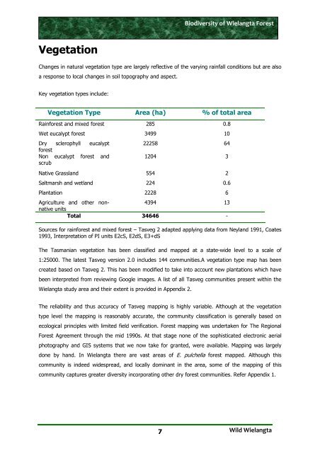
Key vegetation types include:<br />
Vegetation Type Area (ha) % <strong>of</strong> total area<br />
Rainforest and mixed forest 285 0.8<br />
Wet eucalypt forest 3499 10<br />
Dry<br />
forest<br />
sclerophyll eucalypt<br />
Non<br />
scrub<br />
eucalypt forest and<br />
22258 64<br />
1204 3<br />
Native Grassland 554 2<br />
Saltmarsh and wetland 224 0.6<br />
Plantation 2228 6<br />
Agriculture and other nonnative<br />
units<br />
4394 13<br />
Total 34646 -<br />
Sources for rainforest and mixed forest – Tasveg 2 adapted applying data from Neyland 1991, Coates<br />
1993, Interpretation <strong>of</strong> PI units E2cS, E2dS, E3+dS<br />
The Tasmanian vegetation has been classified and mapped at a state-wide level to a scale <strong>of</strong><br />
1:25000. The latest Tasveg version 2.0 includes 144 communities.A vegetation type map has been<br />
created based on Tasveg 2. This has been modified to take into account new plantations which have<br />
been interpreted from reviewing Google images. A list <strong>of</strong> all Tasveg communities present within the<br />
<strong>Wielangta</strong> study area and their extent is provided in Appendix 2.<br />
The reliability and thus accuracy <strong>of</strong> Tasveg mapping is highly variable. Although at the vegetation<br />
type level the mapping is reasonably accurate, the community classification is generally based on<br />
ecological principles with limited field verification. <strong>Forest</strong> mapping was undertaken for The Regional<br />
<strong>Forest</strong> Agreement through the mid 1990s. At that stage none <strong>of</strong> the sophisticated electronic aerial<br />
photography and GIS systems that we now take for granted, were available. Mapping was largely<br />
done by hand. In <strong>Wielangta</strong> there are vast areas <strong>of</strong> E. pulchella forest mapped. Although this<br />
community is indeed widespread, and locally dominant in the area, some <strong>of</strong> the mapping <strong>of</strong> this<br />
community captures greater diversity incorporating other dry forest communities. Refer Appendix 1.<br />
<strong>Wild</strong> <strong>Wielangta</strong>