Plate Tectonics Short Study Guide - Earth Science Review
Plate Tectonics Short Study Guide - Earth Science Review
Plate Tectonics Short Study Guide - Earth Science Review

Create successful ePaper yourself
Turn your PDF publications into a flip-book with our unique Google optimized e-Paper software.
Name: ________________________ Class: ___________________ Date: __________ ID: A<br />
<strong>Plate</strong> <strong>Tectonics</strong> <strong>Short</strong> <strong>Study</strong> <strong>Guide</strong><br />
Multiple Choice<br />
Identify the letter of the choice that best completes the statement or answers the question.<br />
____ 1. The existence of coal beds in Antarctica indicates that the continent once had ____.<br />
a. been part of Africa c. a cold, dry climate<br />
b. a temperate, rainy climate d. been farther from the equator<br />
____ 2. ____ is a fossil fern that helped support Wegener’s hypothesis of continental drift.<br />
a. Gondwanaland c. Mesosaurus<br />
b. Kannemeyerid d. Glossopteris<br />
____ 3. Many early mapmakers thought <strong>Earth</strong>’s continents had moved based on ____.<br />
a. plate boundary locations c. climatic data<br />
b. fossil evidence d. matching coastlines<br />
____ 4. Continental drift was not widely accepted when it was first proposed because ____.<br />
a. Wegener couldn’t explain why or how the continents moved<br />
b. continental landmasses were too big to move slowly over <strong>Earth</strong>’s surface<br />
c. magnetic and sonar data proved that Wegener’s hypothesis was incorrect<br />
d. mantle convection currents weren’t in motion at that time<br />
____ 5. Compared to ocean crust near deep-sea trenches, crust near ocean ridges is ____.<br />
a. younger c. the same age<br />
b. older d. magnetically reversed<br />
____ 6. Isochron maps of the seafloor indicate that ocean crust is ____.<br />
a. oldest near ocean ridges c. youngest near ocean ridges<br />
b. youngest at deep-sea trenches d. thinnest in subduction zones<br />
____ 7. Features found at divergent boundaries include ____.<br />
a. ocean ridges c. crumpled mountains<br />
b. deep-sea trenches d. island arc volcanoes<br />
____ 8. Subduction results in the formation of ____.<br />
a. a deep-sea trench c. a rift valley<br />
b. a magnetic reversal d. new continental crust<br />
____ 9. Crust is neither destroyed nor formed along which of the following boundaries?<br />
a. convergent c. transform<br />
b. divergent d. magnetic<br />
____ 10. The driving forces of tectonic plates are related to convection currents in <strong>Earth</strong>’s ____.<br />
a. crust c. inner core<br />
b. mantle d. outer core<br />
Completion<br />
Complete each sentence or statement.<br />
11. Wegener’s hypothesis of _________________________ stated that <strong>Earth</strong>’s continents had once been<br />
joined as a single landmass.<br />
1<br />
www.NewYork<strong>Science</strong>Teacher.org/review
Name: ________________________ ID: A<br />
Matching<br />
12. The transfer of thermal energy by the movement of heated matter is ____________________.<br />
13. The theory of _________________________ explains how new ocean crust is created at ocean<br />
ridges and destroyed in deep-sea trenches.<br />
14. <strong>Plate</strong>s come together at ______________________________.<br />
15. A change in <strong>Earth</strong>’s magnetic field is called a(n) _________________________.<br />
Match each item with the correct statement below.<br />
a. magnetometer e. Gondwanaland<br />
b. convection currents f. transform<br />
c. rift valley g. deep-sea trench<br />
d. plate tectonics h. ridge push<br />
____ 16. A device that measures changes in <strong>Earth</strong>’s magnetic field<br />
____ 17. A narrow, elongated depression in the seafloor<br />
____ 18. A narrow, long depression in continental crust<br />
____ 19. Type of boundary characterized by long faults and shallow earthquakes<br />
____ 20. Theory that states that <strong>Earth</strong>’s crust and upper mantle are broken into enormous slabs<br />
____ 21. The mechanisms thought to be associated with plate movements<br />
____ 22. The process that helps to move an oceanic plate toward a subduction zone<br />
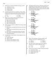
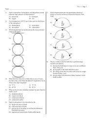
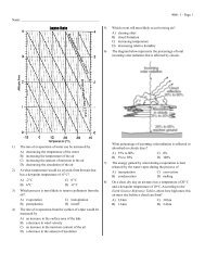
Match each letter that appears on the diagram with the appropriate feature below.<br />
____ 23. Subduction zone<br />
____ 24. Rift valley<br />
____ 25. Volcanoes<br />
<strong>Short</strong> Answer<br />
26. How did Wegener use glacial deposits to support his hypothesis of continental drift?<br />
2<br />
www.NewYork<strong>Science</strong>Teacher.org/review
Name: ________________________ ID: A<br />
27. Listed below are the steps involved in the process of seafloor spreading. Sequence the steps in the<br />
correct order.<br />
The seafloor contracts and sinks.<br />
Crust spreads along an ocean ridge and magma fills the gap that is<br />
created.<br />
New seafloor moves away from the ridge, cools, and becomes more<br />
dense than the material beneath it.<br />
Hot magma which is less dense than surrounding material, is forced<br />
toward the crust.<br />
New ocean floor forms as the magma hardens.<br />
28. Even Alfred Wegener acknowledged that the apparent fit of continents or “matching” of continental<br />
coastlines was crude at best. Propose an explanation for this inexact fit.<br />
29. About 200 million years ago, extensive tropical swamps existed in North America. At the same time,<br />
glaciers covered southern Africa, southeastern South America, much of India, portions of Australia,<br />
and nearly all of Antarctica. How does this information support Wegener’s idea of continental drift?<br />
3<br />
www.NewYork<strong>Science</strong>Teacher.org/review
Name: ________________________ ID: A<br />
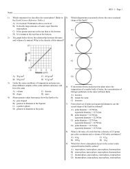
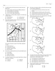
Scientists have studied the motions of <strong>Earth</strong>’s tectonic plates and recorded many of their findings as<br />
maps. Based on the assumption that the direction and rate of plate movement taking place today will<br />
continue for the next 50 million years, researchers have made predictions about the world’s future<br />
geography. The results of those predictions are presented in the diagram below, which shows the<br />
configuration of the continents 50 million years from the present. The shaded areas of the diagram<br />
represent the present positions of the continents.<br />
30. Locate the small strip of land off the northwestern coast of the North American plate. Describe<br />
where you think this land came from and how it got there.<br />
4<br />
www.NewYork<strong>Science</strong>Teacher.org/review
<strong>Plate</strong> <strong>Tectonics</strong> <strong>Short</strong> <strong>Study</strong> <strong>Guide</strong><br />
Answer Section<br />
MULTIPLE CHOICE<br />
1. B<br />
2. D<br />
3. D<br />
4. A<br />
5. A<br />
6. C<br />
7. A<br />
8. A<br />
9. C<br />
10. B<br />
COMPLETION<br />
11. continental drift<br />
12. convection<br />
13. seafloor spreading<br />
14. convergent boundaries<br />
15. magnetic reversal<br />
MATCHING<br />
16. A<br />
17. G<br />
18. C<br />
19. F<br />
20. D<br />
21. B<br />
22. H<br />
23. D<br />
24. A<br />
25. C<br />
SHORT ANSWER<br />
1<br />
ID: A<br />
26. Some areas of South Africa, India, South America, and Australia have glacial deposits. Wegener<br />
reasoned that in order for glaciers to have existed on these continents, the landmasses must have<br />
been closer to the south pole in the past. Over time, the continents drifted to their present locations.<br />
www.NewYork<strong>Science</strong>Teacher.org/review
2<br />
ID: A<br />
27. 5, 2, 4, 1, 3<br />
28. Possible response: <strong>Earth</strong> processes such as weathering, erosion, and deposition continuously change<br />
<strong>Earth</strong>’s landscape, including continental coastlines. Also, the tectonic processes involved in the<br />
formation and break up of Pangaea over 200 million years ago greatly changed <strong>Earth</strong>’s coastlines.<br />
Any such changes could make the fit of continents inexact.<br />
29. About 200 million years ago, Wegener’s supercontinent, Pangaea, was an enormous landmass made<br />
up of all of <strong>Earth</strong>’s present continents. At that time, the land making up present North America must<br />
have been near the equator, where swamps thrived in the tropical climate. Southern Africa,<br />
southeastern South America, much of India, portions of Australia, and nearly all of Antarctica must<br />
have been situated near the south pole, which would account for the presence of glacial deposits<br />
observed in that region of the landmass. Since that time, the continents have drifted to their current<br />
positions and their climates have changed.<br />
30. This small strip of land was once the slice of southern California that is presently west of the San<br />
Andreas Fault. From the map, it appears to have slid north along this transform boundary past the<br />
North American <strong>Plate</strong>.<br />
www.NewYork<strong>Science</strong>Teacher.org/review