

De I. VNER VEW D Forest Trees of the Pacific Slope
De I. VNER VEW D Forest Trees of the Pacific Slope
De I. VNER VEW D Forest Trees of the Pacific Slope

Create successful ePaper yourself
Turn your PDF publications into a flip-book with our unique Google optimized e-Paper software.
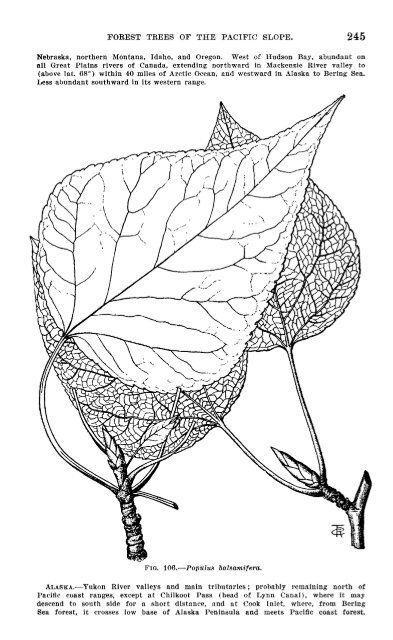
FOREST TREES OF THE PACIFIC SLOPE. 119<br />
extending down east slopes to 6,000 feet, and to 8,100 feet or over on highest peaks;<br />
also on west side in canyons; Kokeep Mountains (east side Warner Lake) only in <strong>De</strong><br />
Garno Canyon. Reported in Blue and Powder River mountains, nor<strong>the</strong>astern part <strong>of</strong><br />
State.<br />
CALIFORNIA.-Nor<strong>the</strong>rn coast ranges and southward on Sierras to sou<strong>the</strong>rn cross<br />
ranges. Nor<strong>the</strong>rn California eastward to Warner Mountains and westward to Siskiyous<br />
(west <strong>of</strong> railroad) ; westward in coast ranges to Russian Creek (west <strong>of</strong> Scott Valley),<br />
Salmon Summit southwest <strong>of</strong> forks <strong>of</strong> Salmon River, at 3,800 to 5,600 feet, Trinity Summit<br />
near meeting point <strong>of</strong> Siskiyou, Humboldt, and Trinity counties, and valley <strong>of</strong> Mad<br />
River west <strong>of</strong> South Fork Mountain. Klamath National <strong>Forest</strong>, at 5,o00 to 7,000 feet;<br />
very common between Horse Creek and Klamath River (T. 47 and 48 N., Il. 8 to 10<br />
W.). Locally noted west <strong>of</strong> Scott Valley between Etna Mills and Sawyers Bar; on<br />
east slope <strong>of</strong> Marble Summit Divide, at 7,400 to 5,500 feet, and westvard on Russian<br />
Creek; mountains north <strong>of</strong> Mount Shasta between Shasta Valley and Butte Creek,<br />
including Goosenest Mountain ; nor<strong>the</strong>ast slope <strong>of</strong> Glass Mountain (12 to 15 miles<br />
south), southwest <strong>of</strong> Tule tLako, and eastward into Modoc County alt tlappy Carmp.<br />
Warner Mountains, both sides, above 6,000 feet; heald <strong>of</strong> Cedarville Canyon, from 6,000<br />
feet up ; head <strong>of</strong> South <strong>De</strong>ep Creek, Sugar 11ill, and south side Fandango Valley (T.<br />
46 N., R. 14 and 15 E.), at 6,000 feet, Big Valley on East Creek, aind Blue Lake. Trinity<br />
Mountains, at 4,500 to 6,000 feet, and sometimes down to 3,000 feet, occurring<br />
throughout Trinity National <strong>Forest</strong> and nearly to Trinity River north <strong>of</strong> Yolabuli; noted<br />
on east slope <strong>of</strong> South Fork Mountain, at 3,500 feet to summit, fand on west side down<br />
into Mad River Valley, which it follows to below 3,000 feet; Yola Buli Ridge; Van Dusen<br />
Canyon ; Canyon Creek canyon, from near <strong>De</strong>drick northward 12 or 13 miles to about<br />
6.500 feet above Twin Lakes; Bully Choop Mountain and ridge. Stony Creek National<br />
<strong>Forest</strong>, at 4,505 to 6,500 feet southward on inner coast range to Clear Lake (sou<strong>the</strong>rn<br />
limit in <strong>the</strong>se ranges), and on Sanhedrin Range to Pine Mountain ; locally noted on<br />
Sheetiron Mountain, Grindstone Creek, St. Johns and Hull mountains, and Black Buttes.<br />
Shasta National <strong>Forest</strong>, at 4,000 to 7,000 feet ; here noted on Mount Shasta from base<br />
<strong>of</strong> Mount Eddy (3,400 feet) to 5,700 feet (Wagon Camp), and on warm slopes to 6,700<br />
or 7,000 feet; south <strong>of</strong> Mount Shasta, over greater part <strong>of</strong> Shasta County, and contimnously<br />
from Mount Shasta to Lassens Peak ; in nor<strong>the</strong>rn Shasta County, going eastward<br />
to Soldier Mountain (near Dana), and ridge between Dana in Fall River Vall-y;<br />
also Big Valley in Lassen County, and from Fall River Valley westwai-d in P'itt Liver<br />
region to point about 3 miles east <strong>of</strong> Montgomery. Occurs in northwestern corner <strong>of</strong><br />
Lassen County from about 5 miles west <strong>of</strong> Bieber, and on east side <strong>of</strong> Big Valley along<br />
Willow Creek 10 miles south <strong>of</strong> Adin and a little far<strong>the</strong>r south near hayden Hill in<br />
sou<strong>the</strong>rn Lassen County, from Susanville westward into Shasta and i'lumas coanties.<br />
Tehtima County, westward on Sierra foothills to about 10 miles east <strong>of</strong> Payne Creek<br />
post-<strong>of</strong>fice; in nor<strong>the</strong>rn Sierras, on both slopes, and on west slope at 3,500 to 7,500 or<br />
8,700 feet. Plumas County, in northwest corner <strong>of</strong> Sierra Valley (near Beckwith) wvestward<br />
on Fea<strong>the</strong>r River to Cromberg, and <strong>the</strong>nce generally distributed; sparingly around<br />
American Valley and westward into Butte County. here common in yellow pine belt from<br />
3 to 4 miles north <strong>of</strong> Bidwell Bar on Fea<strong>the</strong>r River at about 1,300 feet elevation northwestward<br />
along North Fork <strong>of</strong> Fea<strong>the</strong>r River, and nor<strong>the</strong>ashvard along Q-iincy Road to<br />
and beyond Quincy, in Plumas County. Tuba County: Oregon Hills, and eastward to<br />
Bullards Bar, Camptonville, and into Sierra County ; here common in western part<br />
from Camptonville to Downieville, especially from MNlount house down Woodruff Canyon<br />
to canyon <strong>of</strong> North Yuba River ; also along North Yuba to Sierra City and up North<br />
Fork <strong>of</strong> Yuba. Not in Yuba Pass, but begins again on east side at 5,800 feet, continuing<br />
to west border <strong>of</strong> Sierra Valley near Sattley post-<strong>of</strong>fice. Ih sou<strong>the</strong>astern Sierra County,<br />
on east slope <strong>of</strong> main Sierra Divide, and common from point several miles north <strong>of</strong> Prosser<br />
Creek into Nevada County; here abundant near Hobart Mill and Prosser Creek, and<br />
northward into Sierra County ; in Truckee Canyon, southward into Placer County, and<br />
westward to Donner Lake. General in yellow pine belt <strong>of</strong> Stanislaus National <strong>Forest</strong> at<br />
4,000 to 6,000 feet elevation, sometimes down to 3,800 feet and up to 7,500 feet. Placer<br />
County: About Lake Tahoe, northward into Nevada County, and southward into Eldorado<br />
County; mountains east <strong>of</strong> Glenbrook in Nevada ; along railroad from near Donner<br />
(summit) westward below 6,500 feet, and on upper South Fork <strong>of</strong> Yuba River;<br />
Summit Meadows westward to Emigrant Gap; far<strong>the</strong>r west in <strong>De</strong>vils Canyon between<br />
Colfax and <strong>Forest</strong> Hill, and from Iowa Hill eastward, southward, and southwestward to<br />
<strong>Forest</strong> Hill; along railroad between Dutch Flat and Towle Station. Eldorado County:<br />
Tallac; west and south sides <strong>of</strong> Lake Tahoe, into Glen Alpine Canyon, and southward<br />
beyond Grass Lake Valley; west slope Sierras (P'lacerville-Tahoe road), at 2,300 feet,<br />
to Echo, at 5,500 feet. Aspine County: Near Markleville and westward to Silver Creek;<br />
west Carson River canyon. Amador County: North side Mokelumne River above <strong>De</strong>fender;<br />
Pioneer to 3 miles east <strong>of</strong> Pine Grove. Calaveras County: Bigtrees, Gardiners, and


