3. a foot in both camps - Shropshire Walking
3. a foot in both camps - Shropshire Walking
3. a foot in both camps - Shropshire Walking

You also want an ePaper? Increase the reach of your titles
YUMPU automatically turns print PDFs into web optimized ePapers that Google loves.
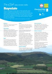
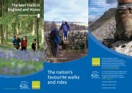
Offa’s Dyke Path Circular Walks<br />
<strong>3.</strong> a <strong>foot</strong> <strong>in</strong> <strong>both</strong> <strong>camps</strong><br />
Five walks on the <strong>Shropshire</strong> border - Llanymynech walk<br />
Straddle the border on this walk of wonders. Offa’s eng<strong>in</strong>eers took a<br />
short cut to meet their K<strong>in</strong>g’s demands, mark<strong>in</strong>g the m<strong>in</strong>eral wealth<br />
of Llanymynech as Mercian by build<strong>in</strong>g on the ramparts of a much<br />
earlier and massive Iron Age fort. The Romans were first to m<strong>in</strong>e<br />
here, pre-dat<strong>in</strong>g Offa’s eng<strong>in</strong>eers by some marg<strong>in</strong>. But Victorian<br />
eng<strong>in</strong>eer<strong>in</strong>g surpassed them all, cutt<strong>in</strong>g these steep cliffs and<br />
build<strong>in</strong>g canals and railways to remove their spoils.<br />
STaRT/FiNiSh POiNT<br />
OS Explorer 240<br />
Park<strong>in</strong>g: Llanymynech Limeworks<br />
Heritage Area (SJ 266210) or<br />
Llanymynech car park beh<strong>in</strong>d the<br />
Dolph<strong>in</strong> Inn and General Stores<br />
(SJ 266210).<br />
Walk ROuTe<br />
Distance: 10km (6¼ miles)<br />
Time: 3½ – 4 hrs<br />
DiFFiCulTY <br />
START <strong>in</strong> Llanymynech on the<br />
1<br />
canal bridge over the Montgomery<br />
Canal (No 92) on the A48<strong>3.</strong> Follow the<br />
canal tow path east (<strong>in</strong>to England), pass<strong>in</strong>g<br />
the bridge abutments where the old<br />
railway crossed the canal, onto the canal<br />
road bridge. Cont<strong>in</strong>ue under and straight<br />
on along what rema<strong>in</strong>s of the tow path,<br />
then up and over the embankment of the<br />
old railway. Then follow a better def<strong>in</strong>ed<br />
tow path over a stile to another stile <strong>in</strong><br />
front of the canal road bridge (No 90).<br />
This is the site of the Old Pant<br />
2<br />
Warf (details on a panel by the<br />
bridge). Follow the tow path for short<br />
distance then over two stiles. From here<br />
the canal and tow path bends around to<br />
the right to meet another canal road<br />
bridge. Do not go through the wooden<br />
wicket gate, but go up the side of the<br />
bridge onto the road and over the canal.<br />
The road bends to the left here,<br />
3<br />
but the walk bears right down and<br />
over the stile to cross the field towards a<br />
clump of trees and cross the stile <strong>in</strong> the<br />
hedge. Head up towards the trees and the<br />
stile and old gate. Cont<strong>in</strong>ue <strong>in</strong>to the lefthand<br />
corner of the field to the stile, and<br />
then follow the right-hand side of the<br />
hedge over the stile by a gate, past a<br />
natural mound on the right to a double<br />
stile by an electricity pole. Go across the<br />
field then over the stile <strong>in</strong> the l<strong>in</strong>e of oak<br />
trees. Cont<strong>in</strong>ue to the stile and gate by<br />
the houses and the road (B4398).<br />
Cross the road (with care) and<br />
4<br />
walk along the pavement towards<br />
the Llynclys term<strong>in</strong>us of the Cambrian<br />
Heritage Railway. Cont<strong>in</strong>ue over the<br />
bridge to the crossroads at the White<br />
Lion and go straight across the road<br />
(with care). Follow the pavement to the<br />
houses and the sign for Turner’s Lane.<br />
Cross over and go along the lane<br />
5<br />
to just past the Nature Reserve<br />
<strong>in</strong>formation board. Turn right along the<br />
bridleway and up the sunken track <strong>in</strong>to<br />
the Reserve to the fork <strong>in</strong> track.<br />
Bear left up the bank to the<br />
6<br />
next junction, turn left to the<br />
“T” junction and go right along the<br />
obvious track past the <strong>in</strong>formation board<br />
on the right. At the “T” junction head<br />
straight on then down to the house, past<br />
the <strong>in</strong>formation board on your right.<br />
Offa’s Dyke Path National Trail • T: 01597 827580<br />
E: odpnt@powys.gov.uk • www.nationaltrail.co.uk/offasdyke<br />
<strong>Shropshire</strong> Council Outdoor Recreation<br />
T: 0345 6789000 • E: countryside.access@shropshire.gov.uk<br />
Primary <strong>Shropshire</strong> Council logo, full colour.<br />
These guides and the podcasts are also downloadable from www.shropshirewalk<strong>in</strong>g.co.uk<br />
Light Blue Pantone 74 61EC<br />
Dark Blue Pantone 281EC<br />
Primary <strong>Shropshire</strong> Council logo, spot colour.<br />
Light Blue Pantone 74 61C<br />
Dark Blue Pantone 281C<br />
Bear right along the track to jo<strong>in</strong><br />
7<br />
the stone wall on the left. Take<br />
the m<strong>in</strong>or track on the right through the<br />
trees, keep<strong>in</strong>g right at the junctions until<br />
the entrance gates to a house. Turn right<br />
to the <strong>in</strong>formation board and steps at the<br />
edge of the escarpment.<br />
Go up the steps known as ‘Jacob’s<br />
8<br />
Ladder’ and follow the path to a<br />
good view po<strong>in</strong>t. Cont<strong>in</strong>ue along the<br />
edge, cross<strong>in</strong>g several stiles, and through<br />
a kiss<strong>in</strong>g gate to meet Offa’s Dyke Path.<br />
Follow the National Trail straight<br />
9<br />
on to the stile cross<strong>in</strong>g the<br />
England / Wales border. Cont<strong>in</strong>ue along<br />
the edge of the golf course and through<br />
the Nature Reserve to reach the old<br />
w<strong>in</strong>d<strong>in</strong>g house on the left.<br />
If you’ve downloaded the podcast,<br />
listen to it here.<br />
Cont<strong>in</strong>ue straight ahead through<br />
10<br />
the wooden kiss<strong>in</strong>g gate and<br />
leave the National Trail to drop down<br />
to the right. Follow the bridleway with<br />
the quarry face on the left to reach the<br />
reconstructed w<strong>in</strong>d<strong>in</strong>g house. Don’t miss<br />
the view po<strong>in</strong>t on the right.<br />
Turn right and walk down the<br />
11<br />
English <strong>in</strong>cl<strong>in</strong>ed plane, through<br />
the kiss<strong>in</strong>g gate to bear right through the<br />
tunnel under the road. Cont<strong>in</strong>ue, keep<strong>in</strong>g<br />
right to pass the Tally House on the left.<br />
Follow the track and then go left<br />
12<br />
between the old railway abutments<br />
follow<strong>in</strong>g the track to the Hoffmann Kiln.<br />
Go past the kiln down the steps<br />
turn<strong>in</strong>g right then left past the old 13<br />
stables build<strong>in</strong>g follow<strong>in</strong>g the track<br />
back to the start.<br />
Primary <strong>Shropshire</strong> Council logo, black.<br />
Black only
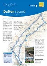
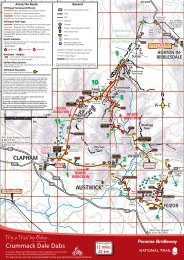
Offa’s Dyke Path Circular Walks<br />
1 mile<br />
1 kilometre<br />
N<br />
Ty-gwyn<br />
Porth-y-waen<br />
Blodwel<br />
Hall<br />
Fron-goch<br />
Llanymynech<br />
Hill<br />
White<br />
Rock<br />
Pen y<br />
Foel<br />
Pen-y-coed<br />
I I I I I I I I I I I I I I I I I I I I I I I I I I I<br />
The Mount<br />
START/FINISH 1<br />
Porth-y-waen<br />
Llanymynech<br />
Hill<br />
8<br />
START/FINISH 1<br />
9<br />
10 11<br />
Pen-y-coed<br />
Blodwel<br />
<strong>3.</strong> a <strong>foot</strong> <strong>in</strong> Hall <strong>both</strong> <strong>camps</strong><br />
Ty-gwyn<br />
Fron-goch<br />
White<br />
Rock<br />
Pen y<br />
Foel<br />
I I I I I I I I I I I I I I I I I I I I I I I I I I I I<br />
The Mount<br />
12<br />
Hoffman<br />
Kiln<br />
13<br />
7<br />
12<br />
Hoffman<br />
Kiln<br />
Crickheath<br />
Hill<br />
Llanymynech<br />
Crickheath<br />
Hill<br />
Five walks on the <strong>Shropshire</strong> 9 border - Llanymynech walk<br />
8<br />
10 11<br />
Whitehaven Pant<br />
6<br />
Pant<br />
Nuttree<br />
Farm<br />
Llynclys<br />
Hill<br />
Llanymynech<br />
5<br />
Plas<br />
cerrig<br />
Lower<br />
House<br />
Llynclys<br />
Farm<br />
Plas<br />
cerrig<br />
2<br />
Lower<br />
House<br />
Offa’s Dyke Path National Trail • T: 01597 827580 • E: odpnt@powys.gov.uk • www.nationaltrail.co.uk/offasdyke<br />
<strong>Shropshire</strong> Council Outdoor Recreation • T: 0345 6789000 • E: countryside.access@shropshire.gov.uk<br />
These guides and the podcasts are also downloadable from www.shropshirewalk<strong>in</strong>g.co.uk<br />
13<br />
2<br />
Tycoch<br />
Farm<br />
Tycoch<br />
Farm<br />
Waen<br />
Wen<br />
KEY<br />
Waen<br />
Wen<br />
Llynclys<br />
3<br />
3<br />
4<br />
New<br />
House<br />
New<br />
House<br />
Ma<strong>in</strong> walk route<br />
Roads<br />
Tracks / paths<br />
Offa’s Dyke<br />
Offa’s Dyke Path<br />
Bridleways<br />
Footpaths<br />
England/Wales<br />
border<br />
Access land<br />
I I I I I I I I I I I I I I I I I I I I I I I I I I I I Quarry rema<strong>in</strong>s<br />
LA Licence No. LA100049049.2010<br />
Primary <strong>Shropshire</strong> Council logo, full colour.<br />
Light Blue Pantone 74 61EC<br />
Primary <strong>Shropshire</strong> Council logo, spot co<br />
Light Blue Pantone 74 61C