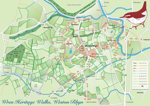
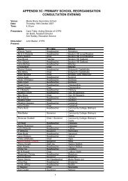
Lime Kilns Chapel Mount Wood Upper Craignant Fron Heulog Fron Rough Offa's Dyke Top Fron SELATTYN HILL Bronygarth To Selattyn Tynyrhos Dinas Tynycelyn Wern Mill CHIRK CASTLE ESTATE TELEPHONE BOX POST BOX Quinta Pontfaen Temple Woods Butcher's Arms New Mills RIVER CEIRIOG Quinta Sunday School Village Hall Weston Rhyn Mill The Last Inn Car Park <strong>Wren</strong> <strong>Heritage</strong> <strong>Walks</strong>, Weston Rhyn BRIDGE Weston Rhyn Weston Mill Upper Hengoed VIADUCT The Cross Keys The Lodge To Chirk AQUADUCT The Plough MORLAS BROOK Chirk Bank Poacher's Pocket Preesgweene CANAL A5 A5 To Oswestry To Wrexham Gobowen St Martin' CANAL
Walk 1 – TREHOWELL WOODS EASY WALK • Approximately 3 miles • TIME about 1 hour Park at the Cross Keys. Turn right out of car park, through village, over level crossing to Canal Bridge No 18, turn left onto tow path, with the canal on your left, continue to The Poacher’s Pocket, up the steps at Bridge No 19, left onto the lane (*1), continue to T-junction, turn left and quick right by a safety barrier, walk between conifer hedges to a road, turn left and quick right by lamp post and wooden fence, straight across the next road, through a metal kissing gate, follow conifer hedge, through the next kissing gate turn right. Over the railway bridge to T-junction, turn left, 250 metres turn left through a wooden gate into Trehowell Woods, turn right under the bridge (*2). At the end of the woods turn left into lane, past a small cemetery and bear left, passing the Quinta Sunday School on the right, this lane ends at the village shop, turn left and return to The Cross Keys. The Cross Keys Public House takes its name from the device on the shield of Renier, the Bishop of St Asaph. The village once belonged to his diocese. *1 By staying on the towpath you can walk along the canal and over the Aqueduct into Chirk. *2 This footpath is used by kind permission of the landowner. Walk 2 – ALONG THE CANAL EASY WALK • Approximately 2 1 ⁄2 miles • TIME about 1 hour Circular route with starting points at The Plough or The Poachers Pocket (both public houses serve food). Turn right out of Plough Car Park, over level crossing, down to Canal Bridge No 18, turn left onto tow path, with the canal on your left, continue to The Poacher’s Pocket, up the steps at Bridge No 19 and right into lane and up to T junction. ( ** This is also the starting point from Poacher’s Pocket). Straight across road, down lane to the left of white cottages. Continue under by-pass bridge onto green lane, turn right at T junction, continue to main road. Turn left, walk along pavement, TAKE CARE THIS ROAD CAN BE VERY BUSY, turn right at cross roads (mirror). Continue down this lane to canal bridge, turn right onto tow path, under by-pass bridge, to next bridge (No 18) leave tow path, turn right and return to the Plough, or stay on tow path to return to the Poacher’s Pocket. Rhyn means “promontory” in Welsh, the settlement of Wes (the farm of Wes) was established at about the time that Offa built his famous dyke and so the area became known as Weston Rhyn.