C O N T E N T S - Ministry of Home Affairs
C O N T E N T S - Ministry of Home Affairs
C O N T E N T S - Ministry of Home Affairs

Create successful ePaper yourself
Turn your PDF publications into a flip-book with our unique Google optimized e-Paper software.
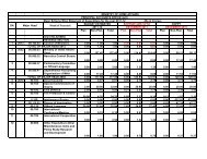
DEVELOPMENT INITIATIVES IN NORTH-EASTERN STATES THROUGH<br />
FIVE YEAR PLANS AND ANNUAL PLANS.<br />
(Source - Planning Commission)<br />
The Government has been resorting to various measures since independence for<br />
Socio-economic development <strong>of</strong> the people <strong>of</strong> the country and formulating schemes for<br />
development <strong>of</strong> infrastructure, education, culture, health, creating job opportunities etc. In<br />
the process, the special needs <strong>of</strong> particular sector in any State and State specific<br />
characteristics are also kept in view and exceptions wherever required have been made for<br />
ensuring balanced growth <strong>of</strong> the country including any region.<br />
Considering the geographical features and special characteristics <strong>of</strong> the NE States,<br />
Central Government Ministries have been resorting to formulating strategies/schemes even<br />
by making special concessions/dispensations in respect <strong>of</strong> the areas Administered by them.<br />
The programs/projects are aimed at improving the socio-economic infrastructure, creation<br />
<strong>of</strong> job opportunities, up gradation <strong>of</strong> culture, education, and creating economic base for<br />
bringing people to the mainstream.<br />
In this context, state specific position in respect <strong>of</strong> Meghalaya is as follows: -<br />
Meghalaya has a geographical area <strong>of</strong> 22,429 sq. km., shares 443 kms border with<br />
Bangladesh in the south and the west and is surrounded by Assam on the north-eastern<br />
side. Its surface area comprises mostly <strong>of</strong> hills and table lands with a small valley land.<br />
The State is endowed with rich natural resources, including forests, hydroelectric power<br />
potential and mineral deposits such as coal, limestone and uranium. The total area under<br />
forest cover is 75.08% <strong>of</strong> the total geographical area. Meghalaya has 7 districts and 5782<br />
villages. The population density was 103 persons per sq. km against the All-India density<br />
<strong>of</strong> 325 persons per sq. km. About 18.50 percent <strong>of</strong> the people in the State were below the<br />
poverty line in 2004-05 against all India level <strong>of</strong> 27.80 percent.<br />
The present road connectivity in the State is 37 Km/100Sq. Km which is much<br />
below the National Average (75 Km /100Sq. Km). About 51% <strong>of</strong> 5782 villages are<br />
connected by roads. The State is well endowed with mineral resources, with a coal reserve<br />
<strong>of</strong> about 560 MT and limestone reserve <strong>of</strong> about 12000 MT along with substantial deposits<br />
<strong>of</strong> industrial clay, kaolin, feldspar and uranium.<br />
Industrial development in the State especially in the SPIP, Byrnihat, industrial area<br />
near Umiam lake and Khliehriat sub station <strong>of</strong> Janitia Hills has taken place in the recent<br />
years.<br />
Meghalaya achieved a growth rate <strong>of</strong> 7.8% in the 9 th Plan. However, it fell to 6%<br />
during the 10 th Plan. The main reason is the inability <strong>of</strong> having infrastructure, particularly<br />
power to sustain and support high level <strong>of</strong> growth. For 11 th Plan, the growth target for the<br />
State is 7.3% against all India growth target <strong>of</strong> 9%. For achieving this growth target the<br />
State needs accelerated development <strong>of</strong> infrastructure especially power and road<br />
connectivity.<br />
2