M.Sc Hydrology - Andhra University, Visakhapatnam
M.Sc Hydrology - Andhra University, Visakhapatnam
M.Sc Hydrology - Andhra University, Visakhapatnam

You also want an ePaper? Increase the reach of your titles
YUMPU automatically turns print PDFs into web optimized ePapers that Google loves.
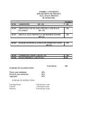
HS 401 ADVANCES IN REMOTE SENSING AND GIS<br />
Unit – 1 Microwave remote sensing: Remote sensing wavelength bands under microwave region;<br />
polarization HH. HV, VH and VV types; passive microwave radiometers, satellites<br />
carried and carrying passive microwave radiometers; advantages and disadvantages of<br />
passive microwave remote sensing; Active microwave remote sensing: side looking air<br />
borne radar (SLAR), synthetic aperture radar (SAR); spatial, range and azimuth<br />
resolutions; radar return and image signatures; dielectric constant; surface roughness and<br />
its impact on return radar signals; depression angle; radar image interpretation; satellites<br />
with active microwave sensors - SEASAT, SIR- A, B, C, ERS, ENVISAT, RADARSAT,<br />
JEIRS and others; characteristics of SAR on above satellites; advantages of microwave<br />
remote sensing; SAR interferometry and differential SAR interferometry and their<br />
applications<br />
Unit - 2 Digital image processing: image structure, conversion of photograph to digital form;<br />
image restoration, atmospheric/haze correction, geometric correction, image<br />
enhancement techniques, linear and non-linear stretch, spatial and directional filters and<br />
their applications on satellite remote sensing data; information extraction: arithmetic<br />
processing of digital data; logarithmic and exponential transforms, multi-spectral<br />
classification of digital data: unsupervised and supervised; parallelepiped, k-nearest<br />
neighbor and maximum likelihood methods.<br />
Unit – 3 Airborne Geophysics: Aeromagnetic methods and sensors; airborne gravity,<br />
electromagnetic and radiometric methods and their sensors; survey procedures in airborne<br />
geophysical investigations. Satellite Geophysics: Experimental satellites and sensors onboard<br />
for geophysical studies - OGO, MAGSAT, OERSTED, CHAMP, DMEIER<br />
LAGEOS-II, RADAR ALTIMETERS on GEOSAT, ERS, ENVISAT, TOPEX-<br />
POSEIDON and other future missions; Application of altimeter data to derive bouger<br />
gravity anomalies; scatterometer and its application.<br />
Unit – 4 Remote sensing applications: Application of aerial photography, satellite optical and<br />
microwave remote sensing data for meteorological, hydrological and geological studies;<br />
monitoring and exploration of renewable and non-renewable resources like groundwater,<br />
mineral and oil; monitoring bio-resources, delineation of environmental pollution like<br />
monitoring green house gases, water pollution, oil pollution of land and water etc.,<br />
natural hazard monitoring and management like earthquakes, land subsidence, land<br />
slides; planning of geophysical investigations etc.<br />
UNIT - 5 Geographical information systems (GIS): Introduction: functions of GIS, spatial data<br />
bases - position, attributes; data base structures; data base management; geographic data<br />
types - vector and raster; introduction to coordinate system and map projections;<br />
application of GIS in <strong>Hydrology</strong> and other earth sciences.<br />
Books :<br />
1. Remote Sensing: Principles and Interpretation , Floyd F. Sabins, JR., \V.H.. Freeman &<br />
Co.; San Francisco, 426 p<br />
2. Introduction to the Physics and Techniques of Remote Sensing ,y Charles Elachi,<br />
Johnwiley & Sons p.413<br />
3. Manual of Remote Sensing, Vol. I & Vol. 11, by American Society for photogrammetry<br />
and Remote Sensing<br />
4. Information Booklets from Various Satellite Agencies<br />
5. Remote Sensing in Sub-surface Exploration, Ed. K.R. Rao and S.K. Bhan, AEG<br />
Publication, p. 152<br />
6. Digital Image Processing by R..C. Gonzalez and R.E. Woods , Pearson Education<br />
(Singapore) Pvt. Ltd., 716 p<br />
7. Remote Sensing in <strong>Hydrology</strong> , E.T. Engman and R.J. Gumey, Chapman and Hall, 222 p.<br />
8. Geographic Information Systems , P. A. Burrough, 193 p<br />
9. Introduction to the Use of Geographic Information systems for practical <strong>Hydrology</strong> ,<br />
A.M.J. Meijerink, H.A.M. de Brower, Chris Mannaerts and Carlos R. Valenzeela, ITC<br />
Publication No. 23, 243 p