M.Sc Hydrology - Andhra University, Visakhapatnam
M.Sc Hydrology - Andhra University, Visakhapatnam
M.Sc Hydrology - Andhra University, Visakhapatnam

Create successful ePaper yourself
Turn your PDF publications into a flip-book with our unique Google optimized e-Paper software.
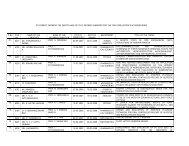
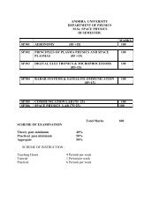
M.<strong>Sc</strong>. HYDROLOGY:<br />
Semester – I Semester - II<br />
Theory Theory<br />
Code Subject Marks Code Subject Marks<br />
HS 101 Geology – I 85+15* HS 201 Geology – II 85+15*<br />
HS 102 Hydrometeorology and 85+15* HS 202 Mathematics 85+15*<br />
Water Balance<br />
HS 103 Geohydrology 85+15* HS 203 Computer Programming 85+15*<br />
HS 104 Surface Water <strong>Hydrology</strong>-I 85+15* HS 204 Surface Water <strong>Hydrology</strong>-II 85+15*<br />
Practicals** Practicals<br />
HS 105 Geology – I 50 HS 205 Geology – II 50<br />
HS 106 Hydrometeorology and 50 HS 206 Computer Programming 50<br />
Water Balance<br />
HS 107 Geohydrology 50 HS 207 Surface Water <strong>Hydrology</strong> 50<br />
HS 108 Viva-Voce 50 HS 208 Viva-Voce 50<br />
Total 600 Total 600<br />
Semester – III Semester - IV<br />
Theory Theory<br />
Code Subject Marks Code Subject Marks<br />
HS 301 Optical Remote Sensing 85+15* HS 401 Advances in Remote Sensing &<br />
GIS<br />
85+15*<br />
HS 302 Hydrochemistry 85+15* HS 402 Environmental <strong>Hydrology</strong> 85+15*<br />
HS 303 Hydrologic Modelling 85+15* HS 403 Watershed Management 85+15*<br />
HS 304 Groundwater Geophysics 85+15* HS 404 Well Hydraulics and Water 85+15*<br />
Wells<br />
Practicals** Practicals<br />
HS 305 Optical Remote Sensing 50 HS 405 Advances in Remote Sensing &<br />
HS 306 Hydrochemistry 50 HS 406 Environmental <strong>Hydrology</strong> 50<br />
HS 307 Groundwater Geophysics 50 HS 407 Project Work 100<br />
HS 308 Viva-Voce 50 HS 408 Viva-Voce 100<br />
Total 600 Total 700<br />
Grand Total 2500<br />
Semester End Examination Marks: 85<br />
* Mid Semester Examination Marks: 15<br />
Theory and Practice Individual Paper Minimum Pass: 40%<br />
Viva-Voce Pass : 50%<br />
Theory, Practical and Viva-Voce Total Aggregate Pass : 50%<br />
** I, & III Semester Practical Examinations will be conducted along with II & IV semester end<br />
practical examinations respectively.<br />
M.<strong>Sc</strong> <strong>Hydrology</strong><br />
GIS<br />
50
HS-101 GEOLOGY I<br />
UNIT I: Basic assumptions in Geology, relation of geology with sciences-branches of geologyfigure<br />
and dimensions of earth, structure, composition and origin of earth-Envelops of the<br />
earth-crust, mantle, core, External dynamic process- weathering, geological work of<br />
wind-weathering, erosion and denudation, cycle of erosion, transportation and deposition<br />
agents-loess, relief. Desert types.<br />
UNIT II: Geological work of surface flowing water-streams, rivers, their development. River<br />
systems-meandering, oxbow lakes, flood plains, peneplains and deltas. Geological work<br />
of underground water-permeability of rocks, types of water in rocks-classification of<br />
underground water-springs. Minerals waters-carbonate, sulphide and radioactive waters.<br />
Karst-forms, landslides, lakes and swamps, estuaries. Internal dynamic process-tectonic<br />
dislocations, neotectonics, earthquakes. Magmatism-volcanoes. Geological work of the<br />
sea-marine basins-relief features of the world, ocean floor. Temperature, salinity of<br />
seawater. Destructive work of sea-near shore accumulation forms-sedimentation in<br />
various zones of sea. Distribution of marine sediments.<br />
UNIT III: Fundamental concepts in geomorphology-geomorphic processes-distribution of<br />
landforms-drainage patterns -development. Morphometric analysis of drainage basins,<br />
water sheds. Elements of hill slopes-pediment, bazadas. Landforms in relation to rock<br />
types, paleochannels, buried channels. Soils types and their classification. Evolution of<br />
major geomorphic process in India. Marine geomorphic processes, coastal<br />
morphological processes. Field and laboratory map scales, topographic maps, thematic<br />
maps, topographic and geomorphic profiles.<br />
UNIT IV: Structural, textural, and chemical classification and origin of igneous, metamorphic and<br />
sedimentary rocks- Petrogenisis, granitisation. Petrographic characters of pegmatites,<br />
kimberlites and gondites- Sedimentary structures- petrographic characters of<br />
conglomerate, sandstone, shale, limestones. Process of dolamitisation. Metamorphismstructural<br />
classification of shale, phyllite, schist, gneiss, marble quartzite and granulites.<br />
UNIT V: <strong>Sc</strong>ience of minerals, physical and optical properties of minerals. Classification, structure<br />
and chemistry of Feldspar, Mica, Pyroxenes, Amphiboles, Olivine, Quartz and Garnet<br />
groups. Clay minerals, genesis and chemistry of native elements. Elements of<br />
crystallography, crystallographic axes, symmetry form of crystals and classification of<br />
crystals.<br />
Books:<br />
l. Physical Geology, G.Gorshkov, A.Yakushova<br />
2. Physical geology, A.K.Datta<br />
3. A textbook of Geology, P. K Mukherjee.<br />
4. The principles of petrology, G.W.Tyrell.<br />
5. Rutleys mineralogy, H.M.Read<br />
6. Physical Geology, Arthur Holmes
HS 102 HYDROMETEOROLOGY AND WATER BALANCE<br />
UNIT-1: Elements of Meteorology:<br />
Hydrologic Cycle, Water Vapour, Atmospheric Humidity, Measurement of Humidity, Atmospheric<br />
Thermodynamics, Formation of clouds. Types of clouds, Air masses, Cyclones, Anti cyclones,<br />
Hurricanes, Tornado, convection, Extra tropical cyclones, Convective weather, Tropical disturbances and<br />
storms, Weather systems and regimes, Monsoons (12 Hours)<br />
UNIT-II: Precipitation;<br />
Condensation and precipitation, Precipitation processes, Forms of Precipitation, Measurement of rainfall,<br />
Types of gauges, Non recording and self-recording gauges, Storage gauges, Radar measurement of<br />
rainfall, intensity of rainfall, Rain gauge network. Distribution and measurement of snow, Standard and<br />
recording snow gauge, Seasonal storage, snow surveying, Radio isotope snow gauge, Intensity saturation<br />
frequency analysis, Spatial and temporal variations, Interpretation of precipitation data.<br />
(12 Hours)<br />
UNIT-III: Soil Moisture:<br />
Formation and mechanical composition of soils, Soil classification, Soil-Water, Water retention in soil,<br />
Water movement in saturated & unsaturated soils and ice lenses, Soil, Air, Soil temperature and soil<br />
structure, Field capacity, Measurement Techniques, Water Movement<br />
(12 Hours)<br />
UNIT-IV: Infiltration:<br />
Concept of Infiltration, Factors affecting Infiltration, Measurement of infiltration, Single ring and Double<br />
ring infiltrometers, Flood type infiltrometers, Rainfall Simulators, Hydrograph analyses to estimate<br />
infiltration, Relation of infiltration to run-off. (12 Hours)<br />
UNIT-V: Evaporation & Evapotranspiration:<br />
Definitions, Evaporation from free water surfaces, Factors effecting Evaporation, Measurement of<br />
evaporation. Estimation of evaporation, Evaporation reduction, Evaporation from soil surfaces,<br />
Transpiration Determination of transpiration, Evapotranspiration Methods of estimation. Soil moisture;<br />
sampling, Lysimeter measurements, Inflow outflow measurements, Integration method, Energy balance,<br />
Vapour transfer and Groundwater fluctuations, EvapoTranspiration equations, Pan evaporometer,<br />
Lysimeter, Thornthwaite approach, Potential and actual evapotranspiration, Energy budget and Penmann<br />
approach, Water Balance Studies, Forecast of climatic Parameters and World Water Balance.<br />
(12 Hours)<br />
Books:<br />
1. Hand book of Applied <strong>Hydrology</strong>,Ven Te Chow<br />
2. Applied <strong>Hydrology</strong> , R.K.Linsley, M.A.Kohler & Paulhus<br />
3. Engineering <strong>Hydrology</strong> , R.S.Varshney<br />
4. <strong>Hydrology</strong> and Water Resources Engineering , R.L.Sharma & T.K.Sharma<br />
5. A textbook of Geology,P.K.Mukherjee<br />
6. Handbook on Principles of <strong>Hydrology</strong> , Donald. M. Grey<br />
7. Groundwater , H.M.Raghunath<br />
8 Facets of <strong>Hydrology</strong> , John C Rodda<br />
9. A textbook of <strong>Hydrology</strong> , Dr. PJayaramiReddy<br />
10. Hydrometeorology and Water Balance , Prof. V.P.Subrahmanyam<br />
HS 103 GEOHYDROLOGY
Unit-1<br />
Geohydrology, Hydrogeology and Groundwater <strong>Hydrology</strong>, Groundwater in Hydrologic cycle,<br />
Occurrence of Groundwater: Aquifer, Aquiclude, Aquifuge and Aquitard, Porosity, Effective porosity,<br />
Vertical distribution of Groundwater; Zone of aeration, zone of saturation, Division of subsurface water.<br />
(12 Hours)<br />
Unit-11<br />
Specific retention, specific yield, Geologic formations as aquifers, Types of aquifers, Storage coefficient,<br />
Groundwater Basins and springs. Water movement in saturated soils, Darcy's law. Permeability, Intrinsic<br />
permeability. Hydraulic conductivity, Transmissivity, Determination of Hydraulic conductivity,<br />
Anisotropic aquifers, Groundwater flow directions, dispersion.<br />
(12 Hours)<br />
Unit-III<br />
Groundwater fluctuations: Secular, Seasonal and Short-term fluctuations due to stream flow,<br />
Evapotranspiration, Meteorological phenomena, tides, Urbanization, Earthquakes and External load, Land<br />
subsidence. (12 Hours)<br />
Unit-IV<br />
Artificial Recharge of Groundwater: Concept, Recharge methods, Basin method, Stream channel method,<br />
Ditch and Furrow method, Flooding method, Irrigation method, Pit method and Recharge well method,<br />
Incidental recharge, Water spreading, Waste water recharge, Recharge mounds and Induced recharge.<br />
(12 Hours)<br />
Unit-V<br />
Salt water intrusion of coastal aquifers: Occurrence of salt water intrusion, the Ghyben - Herzberg<br />
concept, the dynamic concept, Shape and Structure of the interface, Upconing of saline water, Fresh-Salt<br />
water relations in Oceanic Islands, Control of intrusion, Development of Groundwater in intrusion areas.<br />
(12 Hours)<br />
Books:<br />
1. Hand book of Applied <strong>Hydrology</strong>,Ven Te Chow<br />
2. Groundwater <strong>Hydrology</strong> , D.K.Todd<br />
3. Facets of <strong>Hydrology</strong> , John C Rodda<br />
4. Groundwater ,H.M.Raghunath<br />
5 Groundwater Mannual , U.S.Department of the Interior<br />
6 Hydrogeology , Davis & De weist<br />
7. Geohydrology , De weist<br />
8. Applied <strong>Hydrology</strong>, K.N.Mutreja<br />
9. A textbook of <strong>Hydrology</strong>, prof. PJayaramireddy<br />
10. Applied <strong>Hydrology</strong> , R.K.Linsley, M.A.KohIer & Paulhus
UNIT-1<br />
HS 104 SURFACE WATER HYDROLOGY-I<br />
'The main content of hydrology, <strong>Hydrology</strong> as a science, the relation of <strong>Hydrology</strong> to other sciences,<br />
Historical development of <strong>Hydrology</strong>. (4 Hours)<br />
The significance of water in different fields of anthropogenic human activities and its role in the<br />
development of civilization. Water resources of the earth. Global water budget. (4 Hours)<br />
Interrelation between hydrological processes and atmosphere, hydrosphere and lithosphere, Hydrologic<br />
cycle. (4 Hours)<br />
UNIT-II<br />
Formation of surface water resources; streams, rivers, lakes, swamps, caves, seas and oceans. Definition<br />
of river, river basin and water divide, formation of river valleys, flood plains, fluvial deposits, alluvial<br />
fans, meandering of rivers, formation of ox-bow or horse shoe lakes, deltas, solution valleys and karst<br />
topography ( 8 Hours)<br />
Sediment discharge, sediment transportation, sediment yield of watersheds, suspended load and bed load<br />
measurements. (4 Hours)<br />
UNIT-III<br />
Runoff, virgin flow, surface runoff, overland flow, sub surface runoff, groundwater runoff, direct runoff,<br />
base flow and total runoff. Precipitation excess, effective precipitation, disposition of total precipitation to<br />
total runoff, runoff phenomena, factors affecting runoff, disposition of storm rainfall and estimation of<br />
runoff, φ-index, W-index and W-minimum index.<br />
(12 Hours)<br />
UNIT-IV<br />
Definition of discharge, units of discharge measurement, objects of discharge measurement.<br />
Determination of stage, stage indicators, gauge site, essential requirements of gauge sites, types of<br />
gauges, selection of discharge sites, segmentation and depth measurements Stage<br />
discharge relationship and extension of rating curves (4 Hours)<br />
UNIT-V<br />
Current meter: Gurely current meter, Rotating cup current meter, Pigmi current meter and Optical current<br />
meter. Velocity measurements: Velocity distribution method, one point, two point, three point, six point,<br />
integration and surface velocity methods, velocity measurement by floats and velocity rod. Methods of<br />
discharge estimation: Colour velocity method, Salt velocity method, Hydraulic model method, Radio<br />
tracer method, Electronic method, Ultra sonic river gauge and Hydraulic structures. (12 Hours)<br />
Books:<br />
1. Hand Book of Applied <strong>Hydrology</strong> , Ven Te Chow (ed.)<br />
2. Applied <strong>Hydrology</strong> , R.K.Linsley, M. A. Kohler & Paulhus<br />
3. Engineering <strong>Hydrology</strong> ,R.S.Varshney<br />
4. Engineering <strong>Hydrology</strong> , E.M.Wilson<br />
5. <strong>Hydrology</strong> and Water Resources Engineering , R.K.Sharma & T.K.Sharma<br />
6. A Textbook of Geology , P.K.Mukherjee<br />
7. Applied <strong>Hydrology</strong>, K.N. Muthreja<br />
8. Handbook on the Principles of <strong>Hydrology</strong> , Donald M Grey<br />
9. Facets of <strong>Hydrology</strong> , John C Rodda<br />
10. A textbook of <strong>Hydrology</strong> , Dr. P. Jayaramireddy
HS-201 GEOLOGY II<br />
UNIT I: Objectives of structural geology-composition and resolution of forces-stress, strain.<br />
Description of folds. Classification, mechanics and causes of folding. Foliation and<br />
lineation. Classification of faults, brittle and ductile structures, shearing and shear zones.<br />
Classification of unconformities. Map patterns and their uses in determination of large<br />
scale structures. Tectonic evolution of Dharwars, Eastern Ghats, Aravalis, Singhbhum<br />
and Cuddapahs. Evolution of Himalayas and tectonics. Outlines of geological mapping.<br />
UNIT II: Earth and stratified rocks-importance of stratigraphy-geological cycle and time scale.<br />
Stratigraphic nomenclature and classification. Sargur, Dharwar, Singhbhum super<br />
groups, Aravalis and Eastern Ghat Mobile Belts, Cuddapahs, Vindyan and Kurnool<br />
systems, Deccan basalts, Cretaceous formations, and quaternary formations- boundary<br />
problems in stratigraphy.<br />
UNIT III: Geochemical cycle, geochemical exploration methods, classification of elements.<br />
Analytical techniques for geochemical analysis. Outlines of standards preparation.<br />
Instruments and their exposure. Elements of ore petrology, characteristic features and<br />
genesis of ferrous and non-ferrous ore deposits of India. Mettalogeny, origin, migration<br />
and entrapment of petroleum deposits. Properties of source and reservoir rocks.<br />
Petroliferous basins of India- an outline. Classification of coal, ranking, and grading of<br />
coal deposits of India.<br />
UNIT IV: Physiography and divisions of seas and world oceans. Properties of sea water-salinity,<br />
temperature, density. Littoral and sublittoral zones. Continental shelves, slopes, deep<br />
sea, aprons, seamounts and guyots, abyssal plains- Mid ocean ridge system, aseismic<br />
ridges. Coral reefs and their formation. Tectonic domains of oceans, island arcs, trenches,<br />
hotspot mechanism. Turbidity currents and deep sea sediments, placers on the beach and<br />
shelfs, conditions for formation of polymettalic nodules. Law of the seas.<br />
UNIT V: Orogency-continental drift hypothesis-breakup of continents-plate tectonics-convergent<br />
and divergent margins, eustatic changes of sea level, lithosphere. subduction, obduction<br />
and benioff zones, plate margins, mineralisation near plate margin, major and minor<br />
plates. Transform and transcurent faults, driving mechanism of the plates, convection<br />
currents, triple junction, movement of Indian subcontinent. Origin and evolution of life,<br />
fossils and their uses. Biomineralisation studies on fossils, pale ecology, oxygen and<br />
carbon isotopic studies on fossils, and analysis of paleontoiogical record for tracing plate<br />
tectonic process.<br />
Books :<br />
1. Sub marine geology, P.H.Kunen<br />
2. Submarine geology, F.P.Sheppard.<br />
3. Stratigraphy of India, M.S.Krishnan<br />
4. Structural Geology, M.P.Billings<br />
5. Geochemistry, Rankama and Sahama<br />
6. Economic mineral deposits, A-M.Bateman and M.N.Jenson<br />
7. Aspects of Tectonics, focus on south central India, K.S.Valdiya
HS-202 MATHEMATICS<br />
Unit I: Line Integrals, Green's theorem in two-dimensions. Complex Integration, Cauchy' s<br />
Integral theorem, Cauchys Integral formula, Types of Residues, Cauchy's Residue<br />
Theorem, Evaluation of certain improper integrals involving trigonometric functions.<br />
Unit II: Matrices: Principles and definitions, Single value decomposition method. Introduction to<br />
various generalized inversion techniques and their properties. Least square polynomial<br />
approximation: the principle of least squares, least square approximation over discrete<br />
sets of points, Chebysev Polynomial.<br />
Unit III: Numerical Analysis; finding the roots by numerical methods- bisection method, False<br />
position method, Newton-Raphson method. Interpolation: finite difference, symbolic<br />
relations. Interpolation by Newtons formula. Gauss's Central difference formula, Bessel’s<br />
formula, Lagrangian formula and Richardson's extrapolation. Numerical differentiation<br />
and Integration: Maximum and minimum of a tabulated function. Numerical<br />
Integration-Trapezoidal rule, Simpson' s rule, Romberg integration, Weddle's formula.<br />
Unit IV: Numerical solution of differential equations- Introduction, Solution by Taylor series,<br />
Picard's method of successive approximation, Eulers method, Runga-Kutta method.<br />
Finite element methods: Basic concept of the finite element method. Boundary and Initial<br />
value problem, Variational formulation of boundary value problem, Variational methods<br />
of approximation- The Ritz method. Introduction to finite element analysis of I-D and 2-<br />
D problems.<br />
Unit V: Introduction to Classical Optimisation Techniques, Introduction to Linear Programming<br />
and Non-linear Programming, One dimensional minimization methods- Introduction,<br />
Fibonacci method. Introduction to unconstrained optimisation techniques. Introduction<br />
of Steepest descent method, gradient techniques and Marquardt's method.<br />
Books :<br />
1. Higher mathematics for Engineering and <strong>Sc</strong>ience, M.K.Venkata Raman<br />
2. Engineering mathematics, M.K.Venkata Raman<br />
3. Complex Variables, R-C.Churchill<br />
4. Matrix theory for scientific and engineers, Jennings<br />
5. Generalized inverse of matrices and its application, C.K.Rao & S.R.Mitra<br />
6. An Introduction to Finite Element Method, J.N.Reddy<br />
7. Introduction to Numerical analysis, S.S.Sastry<br />
8. Introduction to Numerical analysis, F.B.Hiderbrand<br />
9. Optimisation theory and application, S.S.Rao<br />
HS 203: Computer programming
Unit I: Introduction: General architecture of a computer. Types of computers. Advantage of<br />
digital computers, structure of a computer, programming languages, object program,<br />
compilers and assemblers.<br />
Unit II : Computer Operating systems: Different types of operating systems: Single user<br />
operating system- MSDOS; Basic structure of DOS, DOS commands, Control-<br />
Function keys. DOS editing keys. Formatting etc.; Multi-tasking operating system-<br />
MS WINDOWS, Basic concepts of windows. Advantages of WINDOWS over<br />
MSDOS; Multi-user and multi-tasking operating systems- UNIX, File system in<br />
UNIX, File mangement, UNIX commands and Shell programming.<br />
Unit III: Programming Languages: Structure of FORTRAN-77, programming<br />
'preliminaries, compilation and execution; FORTRAN expressions-<br />
Arithmetic expressions, order of computation, use of parenthesis, value and mode of<br />
expression. Library functions-Flow Charts; Control statements - GOTO, Computed<br />
GOTO and Assigned GOTO statements; Logical expressions, different types of IF<br />
statements. DO statement. Nesting of Control statements, STOP, END and PAUSE<br />
statements; subscripted variables. Arrays and DIMENSION statement; Special<br />
statements - COMMON, DATA statements. Input and Output statements;<br />
Subprograms - Arithmetic statement functions. Function and Subroutine<br />
subprograms, Compilation and debugging.<br />
Unit IV : BASIC programming language: Introduction, Constants, variables and<br />
expressions in BASIC; Input of data. Conditional and loop structure, control<br />
statements, GO SUB functions<br />
UnitV: C programming language: Basic concepts of C; Symbolic and arithmetic<br />
constants and variables; Data types in C Decision control. Loop control and Case<br />
control structures in C; Functions; Pointers and Arrays; Input and Output; Interation<br />
with Hardware through C and Operations on Bits; Some selected Geophysical<br />
problems and their C programs.<br />
Books:<br />
1. Fortran programming. A.K. Jain & M.N.Kesava Rao<br />
2. Fortran 77 programming, V.Rajararnan ,<br />
3. Let us C, Yashavant Kanetkar<br />
4. UNIX shell programming , Yashavant Kanetkar<br />
HS 204 SURFACE WATER HYDROLOGY - II
Unit-I: Hydrographs: Discharge hydrograph, features of a hydrograph, factor affecting shape of<br />
hydrograph, components of hydrograph, base flow separation methods.<br />
(6 Hours)<br />
Unit II: Unit-hydrograph: Principle of unit hydrograph, application of unit hydrograph and its<br />
limitations and derivation of unit hydrograph from simple hydrograph and complex<br />
hydrograph. (6 Hours)<br />
S-hydrograph: Principle, derivation of unit hydrographs from S-hydrograph, synthetic<br />
unit hydrograph, construction of synthetic unit hydrograph for ungauged areas, synthetic<br />
unit hydrograph parameters for Indian catchments.<br />
(6 Hours)<br />
Dimensionless unit hydrograph, its computations, unit hydrograph for design flood<br />
computation, unit hydrograph for computations of inflow to major rivers, computation of<br />
design flood hydrograph instantaneous unit hydrograph.<br />
(6 Hours)<br />
Unit-III: Floods: flood elevation, Flood discharge, flood volume and duration of floods, Flood<br />
estimation, causes of flood, factors affecting flood flow, flood flow determination.<br />
(6 Hours)<br />
Peak discharge: flood formulae, floods of selected frequency, flood records, maximum<br />
probable flood, flood volume, floods from small basins.<br />
Flood frequency: methods of determining flood frequency. (6 Hours)<br />
Unit-IV: Design flood, standard project flood (SPF), standard project storm (SPS), SPS for small<br />
drainage basins, SPF estimates for small and large drainage basins.<br />
(6 Hours)<br />
Maximum probable flood, probable maximum storm, flood control, flood control works,<br />
flood control methods, limitations of flood control measures<br />
(6 Hours)<br />
Unit-V: Flood routing: Definition and scope, mathematics of flood routing, routing methods.<br />
Flood forecasting, functions of flood forecasting and flood warning, flood forecasting<br />
system, flood control methods, flood forecasting in India and other countries.<br />
(12 Hours)<br />
Books:<br />
1. Hand Book of Applied <strong>Hydrology</strong> , Ven Te Chow (ed.)<br />
2. Applied <strong>Hydrology</strong> ,R.K.Linsley, M.A.Koh1er & Paulhus<br />
3. Engineering <strong>Hydrology</strong> , R.S.Varshney<br />
4. Engineering <strong>Hydrology</strong> , E.M.Wilson<br />
5. <strong>Hydrology</strong> and Water Resources Engineering , R.K.Sharma & T.K.Sharma<br />
6. Applied <strong>Hydrology</strong> , K.N.Muthreja<br />
7. Hand book on the Principles of <strong>Hydrology</strong> , Donald M Grey<br />
8. Facets of <strong>Hydrology</strong> , John C Rodda<br />
9. A textbook of <strong>Hydrology</strong>, Dr. PJayaramireddy<br />
10. Hydrological Forecasting , Andersen, M.D, and T.P, Burt<br />
11. Applied Surface <strong>Hydrology</strong> , 0. Starosolszky<br />
12. Floods and drainage , R.C. Penning-Rowsell
HS 301 OPTICAL REMOTE SENSING<br />
UNIT-1 Fundamentals of Remote Sensing: Introduction: basic principles of remote sensing;<br />
electromagnetic spectrum; Planck’s law and wien's displacement law; concept of<br />
incoming short wave and outgoing long wave radiation: passive and active remote<br />
sensing, interaction of electromagnetic radiation with matter; interaction of<br />
electromagnetic radiation with atmosphere; selective and non-selective scattering; impact<br />
of scattering on remotely sensed data; atmospheric windows and absorption bands<br />
UNIT-2 Spectral reflectance properties and Sensors: interaction of electromagnetic radiation with<br />
solids and liquids of the earth's surface; spectral reflectance curves of water, snow,<br />
clouds, and vegetation. Soils/rocks/minerals. Sensors: imaging and non-imaging sensors:<br />
radiometers, spectrometers. Spectroradiometers; <strong>Sc</strong>anner dependent systems: line scan<br />
systems, array scanning systems, multispectral scanner systems: whiskbroom and<br />
pushbroom imaging systems; circular/conical/side scanning systems: sensor<br />
characteristics - spatial resolution, spectral resolution, radiometric resolution and<br />
temporal resolution.<br />
UNIT -3 Aerial photography: various types of aerial cameras and black and white films; scale,<br />
brightness, contrast of photograph; resolution of photograph - resolving power of film<br />
and camera lens; vertical and oblique aerial photographs; methods of aerial photographic<br />
surveys; parallax/relief displacement, stereophotography, mirror arid pocket stereoscopes,<br />
Photomosaic, low and high sun elevation angle photography. Color theory - primary and<br />
secondary colors; additive and subtractive color mixtures to generate colors, color code,<br />
working principle of normal and infrared color films and photographs; color composites -<br />
true, standard false color and false color composites; application of normal and infra red<br />
photographs.<br />
UNIT - 4 Satellite remote sensing: Various platforms used for remote sensing data acquisition; orbits of<br />
satellites; geo-synchronous and sun-synchronous orbits; OPTICAL REMOTE SENSING<br />
SATELLITES: environmental meteorological satellites (past and present) and their<br />
sensors - GOES, Meteosat, INSAT, GMS, NOAA etc.; earth resources observation<br />
satellites (past, present and future) and their sensors - NIMB US/coastal zone color<br />
scanner, Landsat, Spot, Mos, IRS-la, Ib, Ic, Id, p2, p3, p4, p5, p6 etc. Indian remote<br />
sensing activity; future remote sensing missions of ISRO for earth observation.<br />
UNIT-5 Thermal infrared remote sensing: Thermal processes and properties, radiant flux, heat<br />
transfer, atmospheric transmission, thermal properties of materials, thermal infrared<br />
signatures of various rocks and minerals, influence of water and vegetation on thermal<br />
inertia; thermal infrared sensors like infrared radiometers, working principle of thermal<br />
infrared scanner; TIMS etc.; satellites and sensors acquired and acquiring data under<br />
thermal infrared region - HCMM, NOAA-AVHRR, EOS-TERRA, EOS-AQUA,<br />
Geostationery satellite sensors etc.; characteristics of thermal infrared images, relative<br />
comparison of night and daytime thermal infrared imagery; advantage of thermal infrared<br />
remote sensing<br />
Books :<br />
1. Remote Sensing: Principles and Interpretation, Floyd F. Sabins, IR.. W.H.. Freeman & Co., San<br />
Francisco, 426 p<br />
2. Introduction to the Physics and Techniques of Remote Sensing, Charles Elachi: Johnwiley & Sons<br />
p. 413<br />
3. Information Booklets form various satellite agencies<br />
4. Manual of Remote Sensing, Vol. I & Vol. Ed, American Society for photogrammetry and Remote<br />
Sensing
HS-302 HYDROCHEMISTRY<br />
UNIT I: The water molecule, isotopic composition of waters-physical properties of water-latent<br />
heat, density, compressibility, coefficient of cubic expansion, viscosity, surface tension.<br />
Chemical properties-electrolytic dissociation, solubility product, hydrogen ion<br />
concentration, specific electrical conductance, water and electrolytes, organic<br />
constituents, dissolved gases. Law of mass action, chemical equilibrium-activity<br />
coefficient, ionic strength, Debye-Huckel principle, reporting equilibrium status of water<br />
and related norms, calacite, dolomite, fluorite equilibrium-dissolution of solid and<br />
liquids, factors causing solubility changes, solubility in aqueous solution, saturation<br />
index, pH and solubility, redox potential, stability diagrams, specific conductance of<br />
aqueous solutions.<br />
UNIT II: Geochemical processes-dissolution of salts, rock water interaction, role of contactsurface,<br />
residence time. Adsorption and ion exchange, ion selectivity, adsorption process<br />
in unsaturated and saturated zone, base exchange index, sorption and filter effect,<br />
biological processes, organism in ground water, sulphate reduction, influence of higher<br />
plants on chemistry of waters, mobility salts, mobility of ions.<br />
UNIT III: Geochemical classification of waters-magmatic, meteoritic, juvenile waters, oil field<br />
brines, thermal waters- their nature and chemistry. Subterranean waters in oil fields-case<br />
histories. Water associated with natural brines, saltdomes, geysers, and mud volcanoes,<br />
metaliferrous deposits. Groundwater in igneous, metamorphic, and sedimentary rocks.<br />
Unconsolidated aquifer material-clay, marl, silty rocks, gypsum, anhydrates, salt bearing<br />
rocks and limestone deposits. Hydrodynamic zones and geochemistry of water,<br />
metamorphism of waters, chemical relationship of major groups. Coefficient of<br />
Variation, coefficient of metamorphism, ionic ratios-role in interpreting hydrological<br />
problems. Mechanisms controlling the groundwater chemistry.<br />
UNIT IV: Chemical dissolved constituents-major, minor and traces in ground water-source<br />
mechanism. Insoluble constituents, organic substances, suspended matter, dissolved<br />
gases. Sampling of water-rivers, lakes, ponds, open wells, bore wells. Objective of<br />
sampling, plan, extent, frequency of sampling, precautions. Standard laboratory<br />
techniques-titrimetric, colorometric, and spectrophotometry. Instruments-visible and<br />
UV spectrophotometers, ion Selective electrodes, DO meters, pH and conductivity<br />
meters, flame photometers and atomic absorption Spectrophotometer, Inductively<br />
Coupled Plasma (ICP). Preparation of the standards-estimation and Reporting units. Insitu<br />
measurements-pH, conductivity, salinity and dissolved oxygen, chemical demand,<br />
biological demand. Bacteriological studies.<br />
UNIT V: Interpretation of physical and chemical data of water, methods of illustration-pictorial,<br />
bar, circular radial, multivariate schoeller diagrams, four coordinate diagram, stiffs<br />
diagram, horizontal and vertical scale diagram. Plotting on maps-Piper, Wilcox, SAR,<br />
and Gibbs representation, Durov plots. Statistical techniques in presenting hydrochemical<br />
data-correlation, discriminant analysis, factor analysis, principle component analysis,<br />
Exposure to Statistica Soft-ware. Outlines of global hydrochemical soft-ware-Wateq,<br />
Phreeq, Aquachem, MINTEQA2 and UNESCO hydrochemical soft water.<br />
BOOKS:<br />
1. Study and interpretation of the chemical characteristics of Natural wate, USGS Edition ,<br />
J.D.Hem<br />
2. The properties of groundwater, George Mathess<br />
3. Facet of <strong>Hydrology</strong>, J.C.Rodda.<br />
4. Advances in Hydrosciences Vol.2 , Ven te Chow.<br />
5. Physical and Chemical hydrology, Patrick A.Domenico and Franklin W.<strong>Sc</strong>hwartz.<br />
6. Standard methods for the examination of water and waste water, American Public Health<br />
Association, Ed. 1980.<br />
7. Hand Book of applied <strong>Hydrology</strong>, Ven te Chow.<br />
8. Applied Hydrogeology, C.W-Fetter.<br />
9. Groundwater <strong>Hydrology</strong>, D.K.Todd.
HS 303 HYDROLOGIC MODELLING<br />
Unit I: Introduction, Hydrological Prototype system, Conceptual and system representation of<br />
hydrological cycle and water Balance Parameters. Process of model development-Identification<br />
of objectives, system identification, Evaluation and analysis of available data, Stream flow<br />
synthesis; Methods of extending hydrological time series: MASS curve analysis, Random<br />
generation method, MARKOV generation Techniques. Model formulation-Verificationcalibration.Different<br />
Types of Hydrological models: Physical models, Mathematical models.<br />
Introduction to Continuous and Discrete models, Dynamic and Static, Lumped parameter and<br />
Distributed parameter models, Block-Box model, Conceptual model, Stochastic and<br />
Deterministic models. Physical models: Sand models, Tank model to simulate network of<br />
reservoirs; Laboratory tank models used in Electrical resistivity modelling Horizontal and<br />
Vertical HELESHAW (Viscous fluid) model, Electrical analog models, continuous systems:<br />
Conductive liquid and solid analogue models, Discrete systems: Resistance-Capacitance<br />
Networks, Resistance Networks. Application of analog models. Comparison of Analogue and<br />
application of Digital Models.<br />
Unit II: Mathematical models: Hydrological simulation, Classification of simulation models. Event<br />
simulation models, Continuous stream flow simulation models, Urban runoff models Steps in<br />
digital simulation. General components of Hydrologic simulation models, Data need for<br />
Hydrologic simulation. Limitation of simulation, Advantages in simulation.<br />
Unit III: Rainfall-Runoff event simulation models: HEC-1, TR-20, USGS, and SWMM. Continuous<br />
stream flow models: API, USPAHL, SWM-III, NWSRFS, SHE, MIKE 11, MIKE 21 models.<br />
Simulation snow <strong>Hydrology</strong>- Temperature index models, Energy budget models, Snowmelt<br />
runoff model, Model performance evaluation: NASH-SUTCLIFF coefficient, Volume<br />
deviation, Coefficient of determination.<br />
Unit IV: Urban runoff models- Chicago Hydrograph method (CHM), Road research Laboratory method<br />
(RRL), Storage Treatment, Overflow Runoff Model (STORM), SWMM, QUAL-1, DOSAG-1,<br />
PRMS-USGS, HSPF, WATEQ, PHREEQE ect. Water quality models: Surface water quality<br />
models, Non conservation, conservative, Groundwater quantity models: Groundwater flow<br />
equations-confined, leaky confined aquifers, mass balance equation, Dupuit assumption.<br />
Groundwater flow models, Boundary conditions.<br />
Unit V: Finite difference modeling, Iterative alternative direction implicit method. Calculation of heads<br />
with G and B arrays. Computer programme for two-dimensional steady state flow of<br />
groundwater-example. Finite element method-relative advantages and disadvantages of finite<br />
difference and finite element methods. Introduction to MODFLOW. Groundwater<br />
contamination modeling- Solute transport models, Advection models, Advection-Dispersion<br />
models, Advection-Dispersion-Chemical/Biological reaction models.<br />
Books: Groundwater Resources Evaluation, W.C.Walton<br />
Physical principles of water percolation and seepage, J. Bear et al<br />
Groundwater <strong>Hydrology</strong>, D.K.Todd<br />
Theory of Groundwater, A.Varrujt<br />
Advances in Hydro-sciences, Ven Te Chow<br />
Numerical methods in subsurface <strong>Hydrology</strong>, Irwin Remson et al<br />
Computer simulation Techniques in <strong>Hydrology</strong>, George Fleming<br />
Introduction to <strong>Hydrology</strong>, Terrence E Harbaugh<br />
Introduction to <strong>Hydrology</strong>, W. Viessman<br />
Environmental <strong>Hydrology</strong>, V.P.Singh<br />
Applied Hydrogeology , E.W.Fetter
HS-304 GROUNDWATER GEOPHYSICS<br />
UNIT I: Groundwater in Igneous, metamorphic, sedimentary rocks. Exploration Geophysics:<br />
Geological and Geochemical techniques. Importance Of geophysical techniques.<br />
UNIT II Gravity methods: principles, instruments-survey techniques and application to<br />
Groundwater location. Effect of groundwater levels on gravity readings. Magnetic<br />
methods: principles, instruments, and survey techniques, application to groundwater<br />
exploration. Seismic method; principles, instruments, refraction survey, reflection<br />
surveys, survey techniques, depth determination to aquifer boundaries and bed rocks.<br />
UNIT III Electrical methods: Direct current resistivity method specific resistance and apparent<br />
resistivity, Wenner, <strong>Sc</strong>hlumberger, Lee, Dipole-Dipole configurations. Resistivity<br />
profiling and instruments.<br />
Resistivity sounding: procedure, principles, and elementary theory. K, H, Q and A type of<br />
curves. Hydrological significance. Interpretation techniques: Empirical and Quantitative<br />
techniques. Direct and indirect techniques. Cumulative technique, auxiliary curve<br />
interpretation, construction of master curves, and application of computer techniques in<br />
interpretation, correction of electrical data.<br />
UNIT IV Geoelectrical parameters corresponding to hydrological zones (variation of electrical<br />
resistivity with moisture content and water quality). Application of resistivity in<br />
groundwater studies: Mapping stratigraphic units, buried stream channels, mapping fresh<br />
salt water interface, mapping clay layers, mapping water table and movement of<br />
groundwater. Electromagnetic methods: principles, instruments, survey techniques.<br />
Induced polarisation methods: principles, relationship between apparent chargeability and<br />
apparent resistivity.<br />
UNIT V: Induced polarization groundwater-surveys, telluric and magnetotelluric principles,<br />
instrumentation and survey, EM sounding - profiling-dipole and VLF techniques. Bore<br />
hole geophysics: Well logging, techniques- Electric log, Resistivity and density log, sp<br />
log, radiation logging, sonic logging.<br />
Books:<br />
1. Hydrogeology, S.N.Davis and RJ.M.Dewiest.<br />
2. Applied Geophysics, W.M.Telford et. al<br />
3. 0utlines of geophysical prospecting, M.B.Ramachandra Rao<br />
4. Applications of Surface Geophysics to Groundwater investigations, A.A.R.Zohdy et al.<br />
5. Introduction to Geophysical Prospecting , M.B.Dobrin and Savit.<br />
6. Direct current Geoelectric sounding principle and interpretation, P.K.Bhattacharya and<br />
H.P.Patra.
HS 401 ADVANCES IN REMOTE SENSING AND GIS<br />
Unit – 1 Microwave remote sensing: Remote sensing wavelength bands under microwave region;<br />
polarization HH. HV, VH and VV types; passive microwave radiometers, satellites<br />
carried and carrying passive microwave radiometers; advantages and disadvantages of<br />
passive microwave remote sensing; Active microwave remote sensing: side looking air<br />
borne radar (SLAR), synthetic aperture radar (SAR); spatial, range and azimuth<br />
resolutions; radar return and image signatures; dielectric constant; surface roughness and<br />
its impact on return radar signals; depression angle; radar image interpretation; satellites<br />
with active microwave sensors - SEASAT, SIR- A, B, C, ERS, ENVISAT, RADARSAT,<br />
JEIRS and others; characteristics of SAR on above satellites; advantages of microwave<br />
remote sensing; SAR interferometry and differential SAR interferometry and their<br />
applications<br />
Unit - 2 Digital image processing: image structure, conversion of photograph to digital form;<br />
image restoration, atmospheric/haze correction, geometric correction, image<br />
enhancement techniques, linear and non-linear stretch, spatial and directional filters and<br />
their applications on satellite remote sensing data; information extraction: arithmetic<br />
processing of digital data; logarithmic and exponential transforms, multi-spectral<br />
classification of digital data: unsupervised and supervised; parallelepiped, k-nearest<br />
neighbor and maximum likelihood methods.<br />
Unit – 3 Airborne Geophysics: Aeromagnetic methods and sensors; airborne gravity,<br />
electromagnetic and radiometric methods and their sensors; survey procedures in airborne<br />
geophysical investigations. Satellite Geophysics: Experimental satellites and sensors onboard<br />
for geophysical studies - OGO, MAGSAT, OERSTED, CHAMP, DMEIER<br />
LAGEOS-II, RADAR ALTIMETERS on GEOSAT, ERS, ENVISAT, TOPEX-<br />
POSEIDON and other future missions; Application of altimeter data to derive bouger<br />
gravity anomalies; scatterometer and its application.<br />
Unit – 4 Remote sensing applications: Application of aerial photography, satellite optical and<br />
microwave remote sensing data for meteorological, hydrological and geological studies;<br />
monitoring and exploration of renewable and non-renewable resources like groundwater,<br />
mineral and oil; monitoring bio-resources, delineation of environmental pollution like<br />
monitoring green house gases, water pollution, oil pollution of land and water etc.,<br />
natural hazard monitoring and management like earthquakes, land subsidence, land<br />
slides; planning of geophysical investigations etc.<br />
UNIT - 5 Geographical information systems (GIS): Introduction: functions of GIS, spatial data<br />
bases - position, attributes; data base structures; data base management; geographic data<br />
types - vector and raster; introduction to coordinate system and map projections;<br />
application of GIS in <strong>Hydrology</strong> and other earth sciences.<br />
Books :<br />
1. Remote Sensing: Principles and Interpretation , Floyd F. Sabins, JR., \V.H.. Freeman &<br />
Co.; San Francisco, 426 p<br />
2. Introduction to the Physics and Techniques of Remote Sensing ,y Charles Elachi,<br />
Johnwiley & Sons p.413<br />
3. Manual of Remote Sensing, Vol. I & Vol. 11, by American Society for photogrammetry<br />
and Remote Sensing<br />
4. Information Booklets from Various Satellite Agencies<br />
5. Remote Sensing in Sub-surface Exploration, Ed. K.R. Rao and S.K. Bhan, AEG<br />
Publication, p. 152<br />
6. Digital Image Processing by R..C. Gonzalez and R.E. Woods , Pearson Education<br />
(Singapore) Pvt. Ltd., 716 p<br />
7. Remote Sensing in <strong>Hydrology</strong> , E.T. Engman and R.J. Gumey, Chapman and Hall, 222 p.<br />
8. Geographic Information Systems , P. A. Burrough, 193 p<br />
9. Introduction to the Use of Geographic Information systems for practical <strong>Hydrology</strong> ,<br />
A.M.J. Meijerink, H.A.M. de Brower, Chris Mannaerts and Carlos R. Valenzeela, ITC<br />
Publication No. 23, 243 p
HS-402 ENVIRONMENTAL HYDROLOGY<br />
UNIT I: Man and environment-scope of environmental hydrology-relation with other sciences-<br />
Ecosystem, ecological stability, ecological imbalance and pollution. Global threat-EInino<br />
effect -Green House Effect-Ozone layer depletion and its impact on hydrological<br />
environment-Global Warming-precipitation and ecodistribution-aquatic ecosystems-<br />
anthropogenic impact on aquatic ecosystem- acid rain- its cause and impact on<br />
environment.<br />
UNIT II: Ground water pollution- its and sources and classification- nature of contaminant-point<br />
source and non-point source-municipal dumps-hospital waste-slumps-their impact on<br />
bacteriological contamination of water. Water sanitation-Epidomology and water borne<br />
diseases, Groundwater problems that originate on the land surface-agricultural, industrial,<br />
and atmospheric origin.High way traffic borne contaminants and its impact on<br />
groundwater.Groundwater quality problems that originate above and below water table.<br />
Natural inorganic constituents and their role in usage of water- bicarbonate, carbonate,<br />
calcium, and magnesium, chloride and sodium, potassium, sulphate, fluoride and its<br />
relation with other elements, iron, manganese, arsenic. Excess pumping on coastal areasits<br />
impact on groundwater quality-mining activity - mineral and hydrocarbons and their<br />
impact on quality of water. Aquaculture and its impact on groundwater quality.<br />
UNIT III: Utility of water, for drinking, agriculture, industry and recreation. Standards of water-<br />
Indian, World Health Organisation, Environmental Protection Agency. Water and its<br />
suitability norms for drinking -Using Piper classification, Suitability of water agricultural<br />
classification using-Kelly’s ratio. Sodium adsorption ratio, residual sodium carbonate,<br />
magnesium hazard, soluble sodium percent, Wilcox classification. Water logged areas<br />
and their impact on major ion concentration and nutrients-Bacteriological contamination,<br />
limits of MPN and E.Coli range for safe drinking, characteristics of water qualityhardness-its<br />
classification, pH, redox potential, specific electrical conductance, total<br />
dissolved solids. Norms for corrosion and scale formation characteristics, norms for<br />
identifying salt water intrusion through ionic ratios, groundwater-mixing plots. Reporting<br />
genesis of water through-Gibbs, Durov plots. Piper classification.<br />
Unit IV: Identification of contaminant and its movement- through hydrochemical methods, role of<br />
Geophysical strategies in identification of contaminant transport and extent- Electrical<br />
resistivity methods. Self potential methods, saltwater interface demarcation in coastal<br />
aquifers and water logged areas by electromagnetic method- Radioactive methods- radio<br />
isotope equipment, selection of radio active tracers, environmental isotopes, injected<br />
tracers, application of radio isotopes in environmental problems.<br />
Unit V: Control measures of contaminant into groundwater-prediction of migration, potential<br />
contaminants and travel times, problem of fluoride and arsenic. Defluorination-Nalgonda<br />
method, activated carbon method- Alternate source of supply-development of aquifer<br />
protection plan, emergency response plans, regulation for waste disposal-in and around<br />
human habitats. Control of Volatile Organic Substances in drinking water. Water<br />
treatment-UV method, reverse osmosis, in ground treatment, cutoff trenches,<br />
groundwater dams. Design and optimisation of groundwater monitoring networks for<br />
pollution studies-monitoring cyclic fluctuations in groundwater quality- Environmental<br />
Protection Laws.<br />
BOOKS:<br />
1. Concepts of Ecology, Edward.J.Kormondy<br />
2. Protection of public water supplies from groundwater contamination, US Environmental<br />
Protection Agency Publication 1985<br />
3. Study and interpretation of the chemical characteristics of Natural water- II USGS<br />
Edition by J.D. Hem<br />
4. The properties of groundwater, George Mathess<br />
5. Facet of <strong>Hydrology</strong>, J.C.Rodda.<br />
6. Advances in Hydrosciences Vol.2, Ven te Chow.<br />
7. Physical and Chemical hydrology, Patrick A.Domenico and Franklin W.<strong>Sc</strong>hwartz<br />
8. Groundwater resources evaluation, W.C.Walton<br />
9. Groundwater <strong>Hydrology</strong>, H.Bouwer<br />
10. Hydrogeology, K.R.Karanth.
HS 403 WATERSHED MANAGEMENT<br />
Unit-I: Watershed: Concept, Characteristics, Size, Shape, Physiography, Climate, Drainage, Landuse,<br />
Hydrological parameters. Basic data collection, Concepts of Integrated Study of<br />
Watershed Management. Conditions to develop watershed, Geological Considerations, Types<br />
of Watersheds, Integrated studies to develop watersheds. Rain water structures, design and<br />
Economic aspects. Soil and water consideration. Role of Remote sensing in establishing<br />
watersheds.<br />
Unit-II: Contour Demarcation, Levelling and shaping, Bunding, Hedging, Terracing, Gully control,<br />
Check dams, Mini percolation tanks, Percolation Sunken gully pits, Boundary Bunds, Contour<br />
Bunds, Dug wells, Bore wells, Continuous contour Trenches, sub-surface dams, Tanks,<br />
Diversion structures, Soak pits and Trenches in Urban areas. Public soak pits. Increasing<br />
recharge in heavily silted tanks, Recharge through existing dug wells, Recharge pits, Cover<br />
crops, Trees. Watersheds and its Impact on Environment, Socioeconomic, Water quality,<br />
Remedial measures in adverse conditions-Case histories.<br />
Unit-III: Pebble bunds, Water bunds, Water absorption Trench, Diversion drains, Vegetative Barriers,<br />
Sand bag structure, Brush wood dams, Stone check, Rock fill dam, Gabians, Sunken ponds,<br />
Farm ponds, Check walls, Check dams, pick up anicut, Nala bund.<br />
Unit- IV: Watershed and Agricultural Practices: Crop pattern, Soil enrichment, Field moisture,<br />
Seasonal variations, Biomass management, Sprinkler Irrigation, Drip Irrigation, Pot<br />
Irrigation, Microcatchment farming, Types of farming, Cropland Percolation losses. Wateruse,<br />
Afforestation, Social Forestry, Role of Women in Watersheds.<br />
Unit-V: National projects, Appropriate Technology and action plans, Postoperative problems of<br />
watersheds, chemical weathering in watersheds, Hydrochemical response of a forested<br />
watershed to storms, hill slope contribution to storm flow, upper watershed solute sources,<br />
lower watershed solute sources. Factors affecting the response of small watersheds to<br />
precipitation in humid areas, stream flow generation in a forested watershed. Impacts and<br />
Remedial measures, Isotope studies in estimating inputs to Ecosystems, influence of surface<br />
area, surface characteristics and solution composition and weathering rates. Acidification of<br />
Aquatic ecosystems.<br />
Books:<br />
1. Groundwater Resources Evaluation, W.C.Walton<br />
2. Hand book of Applied <strong>Hydrology</strong>, Ven Te Chow<br />
3. Ground Water, H.M.Raghunath<br />
4. Hydrogeology, Davis & De Wiest<br />
5.Watershed Management, J.V.S.Murthy<br />
6.Facets of <strong>Hydrology</strong>, John C Rodda<br />
7.Watershed Development, V.V.J.Sarma, C.Subba Rao and N.V.B.S.S.Prasad<br />
8.Watersheds Compherehensive Development, K.V.Seshagiri Rao<br />
9.<strong>Hydrology</strong> &Watershed Management, B.Venkateswara Rao
HS 404 WELL HYDRAULICS & WATER WELLS<br />
Unit – I : Groundwater movement; Basic flow equations. Steady flow, unsteady flow, and the analysis-<br />
Flow nets, refraction at permeable boundaries. (12 Hours)<br />
Unit – II : Well hydraulics: Steady undirectional flow and steady radial flow for confined and<br />
unconfined aquifers,<br />
Well in uniform flow. Unsteady radial flow for confined unconfined and leaky aquifers.<br />
(12 Hours)<br />
Unit-III : Multiple well system, partially penetrating wells, well losses.<br />
Well flow near aquifer boundaries: Image well theory, recharge boundary and barrier<br />
boundary and other boundaries. (12 Hours)<br />
Unit – IV : Pumping tests: Conducting pumping tests, Theis, Jacob, Chow and Papadopulous methods of<br />
determining aquifer parameters, recovery test: Determination of transmissivity, storage<br />
coefficient, specific yield and specific capacity, recovery test.<br />
(12 Hours)<br />
Unit – V : Water wells: Dug wells, Bored wells, Driven wells, Jetted wells, Methods for drilling deep<br />
wells, Well design, Well completion, Well development, pumping equipment, Protection of<br />
wells, Well rehabilitation and Horizontal well.<br />
(12 Hours)<br />
Books:<br />
1. Hand Book of Applied <strong>Hydrology</strong>, Ven Te Chow (ed.)<br />
2. Groundwater, D.K.Todd<br />
3. Analysis of pumping test data, G.P. Kruseman and N.A.De Ridder<br />
4. Groundwater resource evaluation, W.C.Walton<br />
5. Groundwater Manual, U.S. Department of the Interior<br />
6. Applied <strong>Hydrology</strong>, K.N.Mutreja