Garmin / GPS 12 series
Garmin / GPS 12 series
Garmin / GPS 12 series

You also want an ePaper? Increase the reach of your titles
YUMPU automatically turns print PDFs into web optimized ePapers that Google loves.
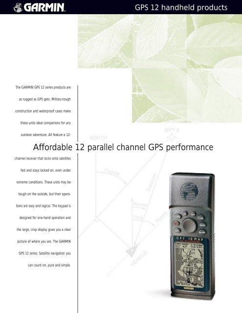
The GARMIN <strong>GPS</strong> <strong>12</strong> <strong>series</strong> products are<br />
as rugged as <strong>GPS</strong> gets. Military-tough<br />
construction and waterproof cases make<br />
these units ideal companions for any<br />
outdoor adventure. All feature a <strong>12</strong>-<br />
channel receiver that locks onto satellites<br />
fast and stays locked on, even under<br />
extreme conditions. These units may be<br />
tough on the outside, but their opera-<br />
tions are easy and logical. The keypad is<br />
designed for one-hand operation and<br />
the large, crisp display gives you a clear<br />
picture of where you are. The GARMIN<br />
<strong>GPS</strong> <strong>12</strong> <strong>series</strong>. Satellite navigation you<br />
can count on, pure and simple.<br />
<strong>GPS</strong> <strong>12</strong> handheld products<br />
Affordable <strong>12</strong> parallel channel <strong>GPS</strong> performance
<strong>GPS</strong> <strong>12</strong> <strong>series</strong> specifications<br />
Navigation features<br />
Routes: 20 reversible routes with up to 30 points<br />
each, plus MOB and TracBack modes<br />
TracBack : Automatic track log navigation<br />
Map datums: 107 including one User Datum<br />
Coordinates: Lat/Lon, UTM/UPS, plus other grids, including<br />
Maidenhead and User Grid<br />
Performance<br />
Receiver: <strong>12</strong> parallel channel receiver continuously<br />
tracks and uses up to <strong>12</strong> satellites to<br />
compute and update position<br />
Acquisition times: Approx. 15 seconds warm, 45 seconds cold,<br />
5 minutes with AutoLocate and 45 seconds<br />
with EZinit, easy initialization<br />
Update rate: 1/second, continuous<br />
Accuracy: 15 meters (49 feet) RMS*, 1-5 meters (3-15<br />
feet) RMS with GARMIN GBR 21 D<strong>GPS</strong><br />
receiver (optional) and up to 0.1 knot RMS<br />
steady state velocity<br />
Dynamics: 6g’s<br />
Interfaces: NMEA 0183 and RTCM 104 D<strong>GPS</strong> corrections<br />
Antenna: Internal patch<br />
Here’s how the units are different<br />
battery life<br />
waypoints/icons<br />
track log<br />
languages<br />
Loran TDs<br />
external ant. hookup<br />
voltage range<br />
proximity waypoint<br />
database or map<br />
0899<br />
Power<br />
Source: 4 AA batteries<br />
<strong>GPS</strong> <strong>12</strong> handheld products<br />
Physical<br />
Size: 2.1"W x 5.8"H x 1.2"D (5.3 x 14.7 x 3.1 cm)<br />
Weight: 9.5 ounces (269 g) with batteries<br />
Display: 2.2"H x 1.5"W (5.6 x 3.8 cm) high-contrast<br />
LCD with backlighting<br />
Case: Ultrasonically welded, waterproof<br />
to IPX-7 standards<br />
Temperature range: 5ºF to 158ºF (-15ºC to 70ºC)<br />
5ºF to <strong>12</strong>4ºF (-15ºC to 55ºC) on <strong>12</strong> CX<br />
Memory backup: Internal rechargeable lithium battery<br />
Accessories<br />
Standard: User’s manual<br />
Quick reference guide<br />
Wrist strap<br />
Batteries and carrying case<br />
standard on <strong>12</strong>XL and <strong>12</strong>CX<br />
PC interface cable<br />
standard on <strong>12</strong>MAP<br />
<strong>GPS</strong> <strong>12</strong> <strong>GPS</strong> <strong>12</strong>XL <strong>GPS</strong> <strong>12</strong>CX <strong>GPS</strong> <strong>12</strong>MAP<br />
24 hours<br />
500/yes<br />
1024 points<br />
9<br />
yes<br />
no<br />
5-8 volts<br />
yes<br />
no<br />
24 hours<br />
500/yes<br />
1024 points<br />
9<br />
yes<br />
yes<br />
10-32 volts<br />
yes<br />
city point database<br />
36 hours<br />
1000/yes, 4 colors<br />
2048 points<br />
9<br />
yes<br />
yes<br />
10-32 volts<br />
yes<br />
city point database<br />
36 hours<br />
500/yes<br />
1900 points<br />
English only<br />
no<br />
yes<br />
10-32 volts<br />
no<br />
detailed basemap;<br />
MapSource compatible<br />
M01-10099-00<br />
© 1999 GARMIN Corporation<br />
GARMIN International<br />
<strong>12</strong>00 East 151st Street<br />
Olathe, Kansas 66062, U.S.A.<br />
913/397.8200 fax 913/397.8282<br />
Graphic steering<br />
guidance keeps<br />
you onurse.<br />
Download streetlevel<br />
mapping<br />
detail from<br />
compatible CDs to<br />
the <strong>GPS</strong> <strong>12</strong>MAP.<br />
The color screen<br />
on the <strong>GPS</strong> <strong>12</strong>CX<br />
helps you sort<br />
out informationfilled<br />
pages.<br />
GARMIN (Europe) Ltd.<br />
Unit 5, The Quadrangle,<br />
Abbey Park Industrial Estate,<br />
Romsey, SO51 9AQ, U.K.<br />
44/1794.519944 fax 44/1794.519222<br />
GARMIN (Asia) Corporation<br />
3rd Floor, No.1, Lane 45, Pao-Hsing Road<br />
Hsin-Tien, Taiwan<br />
886/2.917.3773 fax 886/2.917.1758<br />
www.garmin.com<br />
Specifications are preliminary and subject to<br />
change without notice.<br />
* Subject to accuracy degradation to 100m<br />
2DRMS under the U.S. Department of Defense<br />
imposed Selective Availability Program.