- Page 1:
SDI Convergence Research, Emerging
- Page 4 and 5:
SDI Convergence. Research, Emerging
- Page 6 and 7:
An Integrated Framework for the Imp
- Page 8 and 9:
Peer Review Board for SDI Convergen
- Page 10 and 11:
domain are or may become important
- Page 12 and 13:
Services taking advantage of multip
- Page 14 and 15: changes that have taken place in th
- Page 17 and 18: The Potential of a National Atlas a
- Page 19 and 20: tion, the Royal Netherlands Geograp
- Page 21 and 22: challenge for the National Atlas Fo
- Page 23 and 24: experience 'instant satisfaction' u
- Page 25 and 26: data are found offered by the data
- Page 27: spread of flora and fauna, especial
- Page 30 and 31: Spatial Data Infrastructure of Spai
- Page 32 and 33: ecords managed through the services
- Page 34 and 35: esult of applying GUI production ru
- Page 36 and 37: 28 Table 1: Mapping between OGC Cap
- Page 38 and 39: 30 Figure 4: Online metadata editio
- Page 40 and 41: ACKNOWLEDGEMENTS This work has been
- Page 43 and 44: Public Sector Geo Web Services: Whi
- Page 45 and 46: Figure 1: Serving geo-information u
- Page 47 and 48: nue. With an increasing number of m
- Page 49 and 50: 3.2 Types of business models Malone
- Page 51 and 52: Not all revenue models described by
- Page 53 and 54: uses this model to finance large-sc
- Page 55 and 56: of web service (WMS, WFS/WCS, WIS,
- Page 57 and 58: REFERENCES Anderson, C. (2008). Fre
- Page 59: INTERVIEWS Jellema, M., DataLand, R
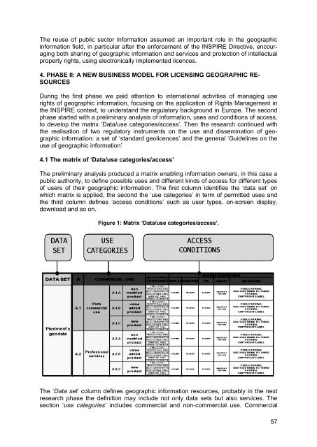
- Page 62 and 63: gion, aware of the INSPIRE context,
- Page 66 and 67: use happens when the final user wil
- Page 68 and 69: Geolicences implementation has draw
- Page 70 and 71: Spatial Information Council (2008).
- Page 72 and 73: make it hard for citizens and civil
- Page 74 and 75: 66 Figure 2: Prototype to test navi
- Page 76 and 77: ”Member States may limit public a
- Page 78 and 79: sor is dragged further into the pro
- Page 80 and 81: cause changes in Dutch and regional
- Page 82 and 83: Hoekstra, R., Winkels R.G.F. and Hu
- Page 84 and 85: The use of location-based informati
- Page 86 and 87: tion which does not measure a perso
- Page 88 and 89: important role (Dobson and Fisher,
- Page 90 and 91: camera surveillance on a public roa
- Page 92 and 93: Furthermore, the Court gave a numbe
- Page 94 and 95: ECtHR (2003a). Peck v. The United K
- Page 97 and 98: Harmonising and Integrating Two Dom
- Page 99 and 100: ing and integrating these two domai
- Page 101 and 102: Table 1: Differences in background
- Page 103 and 104: Figure 1: Examples of IMGeo data (c
- Page 105 and 106: Concept Table 4: Same concept, diff
- Page 107 and 108: Some differences are not clear from
- Page 109 and 110: Such homogenous classes will also a
- Page 111 and 112: BMT classes, which contain all info
- Page 113 and 114: phy, both illustrated with UML exam
- Page 115 and 116:
An Analysis of Technology Choices f
- Page 117 and 118:
The objectives of this article are
- Page 119 and 120:
3. THE COMPARTIMOS REFERENCE MODEL
- Page 121 and 122:
sufficiently simple to allow repres
- Page 123 and 124:
same implementation of a geospatial
- Page 125 and 126:
5. RESULTS Through the development
- Page 127 and 128:
Di L., Chen A., Yang W., Liu Y., We
- Page 129 and 130:
SDI and Metadata Entry and Updating
- Page 131 and 132:
A critical problem for metadata col
- Page 133 and 134:
2.1.8 Functionalities A MET must al
- Page 135 and 136:
Collection of related documents Sta
- Page 137 and 138:
well as more enhanced tools to impr
- Page 139 and 140:
access to geo-referenced databases,
- Page 141 and 142:
metadata and spatial data is new an
- Page 143 and 144:
Phillips, A. and Williamson, I. P.
- Page 145 and 146:
A Prototype Metadata Tool for Land
- Page 147 and 148:
data and grid computing infrastruct
- Page 149 and 150:
model elements it becomes possible
- Page 151 and 152:
Figure 2: Overview of the system co
- Page 153 and 154:
1. selection of a model; 2. provisi
- Page 155 and 156:
the tool is deployed more widely us
- Page 157 and 158:
Chan, T., Beverly C., Ebert, S., Ga
- Page 159 and 160:
Implementation of Recent Metadata D
- Page 161 and 162:
) definition of a metadata organisa
- Page 163 and 164:
3.2 Definition of a metadata schema
- Page 165 and 166:
This is just an example of how comp
- Page 167 and 168:
6. CONCLUSIONS The Public Administr
- Page 169 and 170:
An Integrated Framework for the Imp
- Page 171 and 172:
2.1 Six Sigma Six Sigma is one of t
- Page 173 and 174:
However, the traditional methods of
- Page 175 and 176:
The fifth element for BSC design is
- Page 177 and 178:
Table 2: Strengths and weaknesses o
- Page 179 and 180:
Camp, R. C. (1989). Benchmarking: T
- Page 181 and 182:
Nedovic-Budic, Z., Feeney, M.E.F.,
- Page 183 and 184:
The Value Chain Approach to Evaluat
- Page 185 and 186:
The definition of assessment strate
- Page 187 and 188:
There may be several activities per
- Page 189 and 190:
The complexity of work, which was r
- Page 191 and 192:
Figure 5: Secondary interface: orga
- Page 193 and 194:
on investments. More importantly, i
- Page 195 and 196:
Porter, M. (1985). Competitive Adva
- Page 197 and 198:
Evaluation of Spatial Information T
- Page 199 and 200:
fully digital nationwide spatial da
- Page 201 and 202:
satellite imagery, digital vector d
- Page 203 and 204:
lic) and the National Mapping Agenc
- Page 205 and 206:
- Secondary spatial data available,
- Page 207 and 208:
Figure 1: Technical progress of SDI
- Page 209 and 210:
Khan, J. (2007). Karachi Master Pla
- Page 211 and 212:
Philippines http://www.geoinfo.ait.
- Page 213 and 214:
Local Government and SDI - Understa
- Page 215 and 216:
Australia, like many developed coun
- Page 217 and 218:
Table 1: Structure of the LGA quest
- Page 219 and 220:
(p
- Page 221 and 222:
Table 3: Results of multiple regres
- Page 223 and 224:
The role of local government in bui
- Page 225 and 226:
McDougall, K., A. Rajabifard and I.
- Page 227 and 228:
Changing Notions of a Spatial Data
- Page 229 and 230:
Table 1: Differences between GeoWeb
- Page 231 and 232:
The concept of spatially enabled go
- Page 233 and 234:
applications field and also in term
- Page 235 and 236:
The discussion in the fifth section
- Page 237 and 238:
Cooperation - a Key Factor for Sust
- Page 239 and 240:
appears at low levels and can seek
- Page 241 and 242:
Many of the problems of a non-techn
- Page 243 and 244:
4.4 Important aspects As cooperatio
- Page 245 and 246:
level’ within and between organis
- Page 247 and 248:
Seamless SDI Model - Bridging the G
- Page 249 and 250:
tuaries and oceans (Plunkett, 2001)
- Page 251 and 252:
Figure 2: Seamless administration s
- Page 253 and 254:
Figure 5: Seamless platform. A seam
- Page 255 and 256:
4.2 Standards SDI must be based on
- Page 257 and 258:
One more concern linked to the esta
- Page 259 and 260:
structures that not only do not yet
- Page 261 and 262:
The RRR Toolbox: a Conceptual Model
- Page 263 and 264:
curring in the present must not com
- Page 265 and 266:
databases and web mapping services.
- Page 267 and 268:
Principles, Institutional Principle
- Page 269 and 270:
The commonalities between SDIs and
- Page 271 and 272:
Mooney, J. D. and Grant, D. M. (199
- Page 273 and 274:
Building SDI Bridges for Catchment
- Page 275 and 276:
approaches. TCM is a holistic appro
- Page 277 and 278:
hierarchy namely; the umbrella view
- Page 279 and 280:
tions and practices in South Africa
- Page 281 and 282:
Figure 2: Conceptual framework: App
- Page 283 and 284:
In the Murray Darling Basin, there
- Page 285 and 286:
REFERENCES Australian Bureau of Sta
- Page 287:
Rajabifard, A., M.-E.F. Feeney and