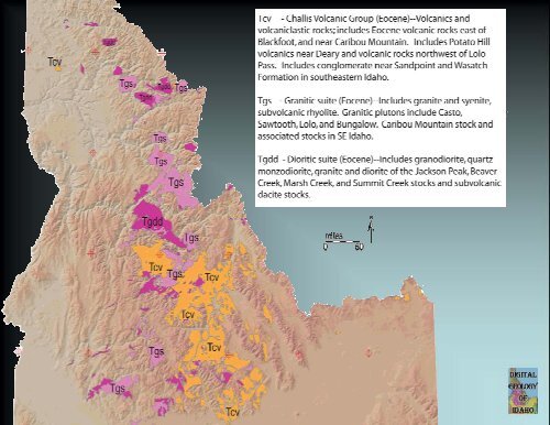
Challis Volcanics
Challis Volcanics
Challis Volcanics

Create successful ePaper yourself
Turn your PDF publications into a flip-book with our unique Google optimized e-Paper software.
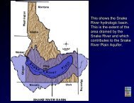
Digital Atlas of Idaho<br />
http://imnh.isu.edu/digitalatlas<br />
Parts of Blaine, Custer, and<br />
Lemhi Counties
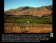
Aerial view of Fall Creek in Pioneer Mountains core complex. Note glaciated<br />
topography cut Eocene granite. Detachement is about halfway into the view,<br />
where the gray soft slopes change to the rocky cliffs.
Geologic map of the Wood River Valley and Smoky Mountains.
Tertiary Eocene granodiorite of the Smoky Mountains.
Upper part of Wood River. Rocks are <strong>Challis</strong> <strong>Volcanics</strong>.
West face of Boulder Mountains. White rocks low down are Eocene granite. Darker<br />
rocks above that include Eocene dacite porphry intrusive rocks and overlying<br />
<strong>Challis</strong> volcanic rocks. Also present are wall rocks of Paleozoic sedimentary rocks<br />
as chocolate chips. In foreground are glacial deposits. Boulder Creek is the<br />
prominent creek. View from the mouth of Baker Creek.
Cross section of Galena quad north of Ketchum,<br />
showing relations on west face of Boulder Mountains.
View of Sawtooth Range from Stanley Ranger Station. Photo by: Jim Cash, IGS
Historical Marker of Yankee Fork mines
Main Salmon River near Yankee Fork.
View of Pennal Gulch Tuff capped by Tuff of <strong>Challis</strong> Creek Outflow unit.
Outcrop of volcanic ash. Photo by: Jim Cash, IGS
View of dacitic / rhyodacitic lava flow
Close-up of <strong>Challis</strong> volcanic rock
View of Tuff of Ellis Cr. With mafic intrusion and K-rich lava flow-<br />
Proterozoic Sediments in foreground.
View of Twin Peaks.
View of <strong>Challis</strong> volcanics looking down Garden Cr. From Fluorspar Mine
Outcrop of dacitic or rhyodicitic lava with<br />
weathered out clasts along Garden Cr. Rd.
Outcrop of Pennal Gulch Tuff capped by Tuff of <strong>Challis</strong> Creek, talus<br />
of <strong>Challis</strong> Creek Tuff in foreground. Photo by Jim Cash, IGS
Closeup of Tuff of Pennal Gulch
Close-up of <strong>Challis</strong> volcanic rock showing texture.
View of Castle Rock - Copper Basin
Close-up of <strong>Challis</strong> volcanics along Big Lost River at Deep Creek.
View of rhyolite domes south of <strong>Challis</strong> (looking 220 deg from Highway 93)
Close-up of Tuff of Camas Cr-Black Mountain showing texture.
Close-up of mafic rock along Lick Creek showing texture. Photo by: Jim Cash, IGS
View of <strong>Challis</strong> volcanics from Cherry Creek Road looking 160 o . Photo by: Jim Cash, IGS
View of Sheep Mountain from Cherry Creek Road. Photo by: Jim Cash, IGS
View of northern Twin Peak. Photo by: Jim Cash, Idaho Geological Survey
View of southern Twin Peak. Photo by: Jim Cash, Idaho Geological Survey
Orofino<br />
Terrane<br />
250<br />
160-130<br />
90-100<br />
1850, 350<br />
Antler<br />
Belt<br />
60 to 80<br />
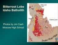
Bitterroot Lobe<br />
Belt 1650-1750<br />
1470-1420, 1500-1600<br />
1800-2000 720-670 480<br />
2400<br />
100-80<br />
Atlanta Lobe<br />
17-14<br />
150, 42-35,<br />
N. Nevada<br />
SRP<br />
17-0 Ma<br />
1370<br />
52-45<br />
<strong>Challis</strong><br />
25 to 40<br />
Rift Basin<br />
12-10<br />
BLT<br />
10-8<br />
Albion<br />
>2500,1800,<br />
720, 550, 350,<br />
32<br />
6-4<br />
1100-1000,<br />
Grenville<br />
via Neoprot-Pz<br />
Teton<br />
>2500<br />
720-670<br />
Over 6000<br />
detrital<br />
zircon analyses<br />
0-2 Y’stone<br />
1650-1750<br />
Belt + 70 via<br />
Cretaceous ss<br />
1100-1000,<br />
Grenville<br />
via Neoprot-Pz
Number<br />
Number<br />
Number<br />
30<br />
25<br />
20<br />
15<br />
10<br />
5<br />
0<br />
0 20 40 60 80 100 120 140<br />
Upper Big Lost River at Lost River Field Station (2PL02) n=39<br />
25<br />
20<br />
15<br />
10<br />
5<br />
0<br />
0 20 40 60 80 100 120 140<br />
Antelope Creek (15PL02) n=37<br />
100<br />
80<br />
60<br />
40<br />
20<br />
0<br />
0 20 40 60 80 100 120 140<br />
Lower Big Lost River (9JG96, 2PL00, T6-66-1,T6-12-1) n=183<br />
“Ghost” Neoproterozoic Grains<br />
A<br />
B<br />
C<br />
Number<br />
Number<br />
Number<br />
3<br />
2<br />
1<br />
0<br />
3<br />
2<br />
1<br />
Relative probability<br />
Relative probability<br />
Relative probability<br />
0 500 1000 1500 2000 2500 3000<br />
Upper Big Lost River at Lost River Field Station (2PL02) n=21<br />
0<br />
0 500 1000 1500 2000 2500 3000<br />
Antelope Creek (15PL02) n=16<br />
9<br />
8<br />
7<br />
6<br />
5<br />
4<br />
3<br />
2<br />
1<br />
0<br />
Big Lost River<br />
System<br />
Abundant Eocene Grains<br />
No Cretaceous Grains<br />
1800-1900 Ma Grains, recycled<br />
Through Miss. Copper Basin<br />
Group, Trans- Hudson derivation<br />
0 500 1000 1500 2000 2500 3000<br />
Lower Big Lost River (9JG96, 2PL00, T6-66-1, T6-12-1) n=50<br />
Relative probability<br />
Relative probability<br />
Relative probability
12<br />
10<br />
8<br />
6<br />
4<br />
2<br />
0<br />
Age ±2? fraction ±2?<br />
580 11 0.06 0.06<br />
637 10 0.14 0.11<br />
670 7 0.29 0.16<br />
703 7 0.32 0.16<br />
736 8 0.19 --relative<br />
misfit = 0.517<br />
500 550 600 650 700 750 800<br />
SHRIMP ages Late Neoproterozoic grains, Big Lost System , n=80
206 Pb<br />
238 U<br />
0.13<br />
0.11<br />
0.09<br />
540<br />
580<br />
620<br />
660<br />
500<br />
Intercepts at<br />
-23±81 & 692.3±5.2 [±6.9] Ma<br />
MSWD = 1.01<br />
0.07<br />
0.6 0.7 0.8 0.9 1.0 1.1 1.2<br />
700<br />
207 Pb/ 235 U<br />
data-point error ellipses are 68.3% conf.<br />
740<br />
780<br />
820
800<br />
760<br />
720<br />
680<br />
640<br />
600<br />
560<br />
520<br />
12KD06 Neoproterozoic orthogneiss<br />
box heights are 2σ<br />
Mean = 691.4±5.2 [0.75%] 95% conf.<br />
Wtd by data-pt errs only, 0 of 16 rej.<br />
MSWD = 0.88, probability = 0.58<br />
(error bars are 2σ)
Number<br />
30<br />
25<br />
20<br />
15<br />
10<br />
5<br />
0<br />
658 +/- 7 Ma<br />
670+/- 8 Ma<br />
677+/- 9 Ma<br />
684+/- 8 Ma<br />
Ghost Grains<br />
0 500 1000 1500 2000 2500<br />
Age (Ma)<br />
8PL02 Wildhorse Creek, Source of the 660 Ma Grains<br />
Number<br />
12<br />
10<br />
8<br />
6<br />
4<br />
2<br />
0<br />
Age of<br />
Intrusive<br />
Rocks in<br />
Pioneer<br />
core<br />
35 40 45 50 55 60 65<br />
Age (Ma)<br />
N=30
206 Pb<br />
238 U<br />
0.6<br />
0.5<br />
0.4<br />
0.3<br />
0.2<br />
0.1<br />
0.0<br />
600<br />
1000<br />
6PL05 Felsic gneiss<br />
Archean plutonic rock with<br />
discordance (zircon<br />
alteration) at 101 Ma (Cretaceous)<br />
FIRST ARCHEAN<br />
2200<br />
AGE IN<br />
PIONEERS!!!<br />
1400<br />
1800<br />
100 Ma<br />
metamorphism and<br />
Pb loss from zircons<br />
2600<br />
Intercepts at<br />
101 ± 15 & 2674.4 ± 9.1Ma<br />
MSWD = 4.8<br />
0 2 4 6 8 10 12 14<br />
207 Pb/ 235 U<br />
data-point error ellipses are 68.3% conf.<br />
Age of<br />
Zircons<br />
(magmatic) =<br />
2700 Ma<br />
Therefore, Archean crust<br />
extends north to Pioneers
6 PL 05 Archean gneiss<br />
6.1 = 2566 +/ 15 Ma<br />
6.2 = 2439 +/- 83 Ma
206 Pb<br />
238 U<br />
0.4<br />
0.3<br />
0.2<br />
0.1<br />
0.0<br />
200<br />
4PL05 Calc silicate gneiss<br />
(from the mafic gneiss)<br />
600<br />
1000<br />
1400<br />
1800<br />
0 2 4 6<br />
207 Pb/ 235 U<br />
data-point error ellipses are 68.3% conf.<br />
Oldest zircons are 1800 Ma<br />
Some rims are 1440 Ma<br />
Data are messy<br />
Rock is likely<br />
A Mesoproterozoic metasediment<br />
(with 1800 to 1440 Ma zircon rims,
30.1 = 1625+/- 7 Ma<br />
20.1 is 1465 Ma<br />
4PL05 Tiny zircon in a metamorphosed calc silicate?
47 Ma pluton<br />
2550 Ma pluton<br />
(orthogneiss)<br />
Metasediment (paragneiss)<br />
Belt Supergroup protolith<br />
695 Ma pluton<br />
From Dover, 1983