DETAILED PROJECT REPORT FOR IWMP‐I‐WAKRO CD BLOCK ...
DETAILED PROJECT REPORT FOR IWMP‐I‐WAKRO CD BLOCK ...
DETAILED PROJECT REPORT FOR IWMP‐I‐WAKRO CD BLOCK ...

Create successful ePaper yourself
Turn your PDF publications into a flip-book with our unique Google optimized e-Paper software.
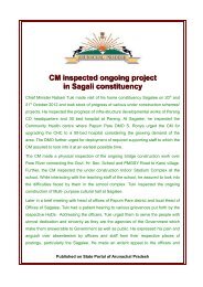
Horticulture<br />
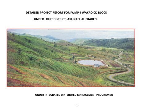
<strong>DETAILED</strong> <strong>PROJECT</strong> <strong>REPORT</strong> <strong>FOR</strong> <strong>IWMP‐I‐WAKRO</strong> <strong>CD</strong> <strong>BLOCK</strong><br />
UNDER LOHIT DISTRICT, ARUNACHAL PRADESH<br />
Forestry<br />
Agriculture on<br />
bench terraces<br />
Water Harvesting<br />
Pond<br />
Valley Land for<br />
Paddy<br />
UNDER INTEGRATED WATERSHED MANAGEMENT PROGRAMME<br />
‐ 1 ‐
INTRODUCTION:<br />
Chapter I<br />
Arunachal Pradesh is situated in the North Eastern Border of India stretching between longitude 90 0 to 30 ’ E and 97 0 30 ’ E and latitude<br />
26 0 28 ’ N and 29 0 31’ N. It spreads over an area of 83,743 sq. km touching the international boundary with Bhutan in the West, China in<br />
the North and Myanmar in the SouthEast. On the south, it is linked with Assam & Nagaland. The State consists of 16 District,45 SubDivisions<br />
and 172 administrative circles with population of is 10,97 ,968 as per 2001 census The State registered a decadal population growth rate<br />
of 27.0 during the decade 199101.<br />
Lohit district is the largest district of Arunachal Pradesh with an area of 5212 sq.km . This district is named after popular river, Lohit. It<br />
is situated between 27 0 30 ’ to 28 0 21’N & 94 0 18 ’ to 95 0 45’ E .It borders Lower Dibang Valley on West, Changlang on the East & China on<br />
the North. It has 2 subdivisions, 6 administrative circles with 5 <strong>CD</strong> Blocks with population of 1,25,086 as per 2001 Census. The district<br />
registered a decadal growth rate of 30.8 during the decade 199101. The district Hq is located at Tezu. Important places for tourists in the<br />
district are Parashuram Khund, Glow Lake & Lohit View etc.<br />
TOPOGRAPHY:<br />
Lohit District is a mountainous tract. On account of the existence of the hill ridges and the valleys its topography assumes typical<br />
character. The hill ridges are situated haphazardly. As soon as one ends the other ridge starts either parallel or in opposite direction. At these<br />
intervals the wide or narrow valleys get the foothills constituting 20 per cent to total geographical area of district. The wide and narrow<br />
valleys share 35 per cent each to total geographical area. The rest about 10 percent is the snow clad peaks. Due to typical topography the<br />
rivers are undulated. There are numerous streams and rivers and are drained by principal riverLohit, Naodihing etc. These principal rivers<br />
of the district are drained by the westerly flowing Brahmaputra. These rivers have rendered the human habitations into geographical<br />
isolations. At the same time these rivers possess high hydropower potential. It could be developed as a good industry. The vast natural<br />
resources have drawn the attention of the Government during recent years.<br />
POPULATION CHARACTERISTICS:<br />
‐ 2 ‐
Lohit under present reference is exclusively a tribal district. Major tribes are: Taraon Mishmis,Kaman Mishmis, Khamptis, Singphos &<br />
Zakhrings & other tribes of districts engaged as Govt. servant and floating population of of general category engaged exclusively on business<br />
& labour classes.<br />
LAND USE:<br />
The land – based enterprises support a large segment of population in the district. The landbased enterprises particularly the<br />
cultivation of field crops as well as horticulture crops is considered a critical determinate of the pace of overall economic development. The<br />
efficient use of land resource, therefore, assumes singular significance with respect to planning of economic activities.<br />
It is sparsely populated with 13 persons per sq.km. Plenty of land is available to the tribesman as natural gift although there is no<br />
land record, the land ownership can be classified under three broad heads: (1) community ownership (2) clan/Individual ownership<br />
and (3) Govt. Ownership.<br />
DRAINAGE SYSTEM:<br />
The drainage system of Arunachal Pradesh is still in an evolutionary stage and, therefore, is immature and is controlled by the main<br />
ranges of the Greater as well as Lesser Himalayas in the Western parts and the frontal ranges and Mishmi hills of the Eastern parts of the<br />
State. The main ranges, peaks, passes, escarpments of these mountains of the Greater Himalayas play a great role in developing the drainage<br />
patterns and acting as ‘water divide’ by following the National as well as International boundary between India and China (Tibet). There are<br />
five well –delineated boundary river system which are the part of Brahamputra system. The administrative boundaries at district level cincide<br />
with the riverbasin boundaries in the state. The Kameng, Subansiri, Siang, Dibang and LohitTellu river system cover most of the part of the<br />
State. But they have different characteristics. The Kurung & kumey rivers form also a part o<br />
The drainage pattern is radial specially in the upper parts of the Greater Himalayan zone of IndoTibetan border. The radial patterns<br />
evolve because of their conical hills and round mountan peaks.<br />
LOHIT RIVER BASIN:<br />
It also has a transitional character developed between the Tirap lineament of the eastern extension of the Himalayas and the Mismi<br />
thrust hills aligning in a NWSE direction through which Krawnaan river passes its water to the Brahmaputra river system. The Lohit river<br />
basin is well developed by the erosional activities of rivers. It is quite large in its size i.e. more than 10,000 sq.km and has a variety of<br />
‐ 3 ‐
topographic features with well drained eight subbasins and two interfluves as the Digaru, the Tiding, the Delei, the middle Lohit, the Upper<br />
Lohit, the Beiang, the Bara Tenga and the Lohit lowland which include two interfluves as the Lohit and the Tellu interfluves<br />
Tellu is main River which forms a well developed rriver system in the area. It flows in the Mismi thrust alongwith the Eastern border of<br />
the state. It enters into Arunachal Pradesh through Du pass of about 2,200, elevation and merges in Brahamputra only at 100m height from<br />
m.s.l. It has gentle slope in almost all its sections with a 2,100m vertical interval at 200 km of total length of the river section.<br />
Overview of the District:<br />
District Profile:<br />
1 2 3 4 5 6 7<br />
Sl.<br />
No.<br />
Name of<br />
District<br />
No. of<br />
Blocks<br />
Total<br />
no. of<br />
villages<br />
Total<br />
no. of<br />
Gram<br />
Panch<br />
ayats<br />
1. Lohit 5 223 761 521200<br />
Geogr<br />
aphical<br />
area in<br />
Ha. SC ST<br />
97<br />
3<br />
‐ 4 ‐<br />
Population (As per the 2001 Census)<br />
Male Female Total<br />
Ot<br />
her<br />
s<br />
SC ST<br />
20532 823 20020<br />
(Source: Directorate of Economics & Statistics/Rural Development / Panch ayat, Itanagar)<br />
Ot<br />
he<br />
rs<br />
SC ST<br />
179<br />
6<br />
Othe<br />
rs<br />
% of BPL<br />
to total<br />
popul<br />
ation<br />
40,552 63.16
Economic Development<br />
The developmental experience of the district has been full of challenges. Apart from its late start, geographical remoteness<br />
and inaccessibility, hilly terrain, lack of infrastructure, population composition, and scarce resource base, the district has indirect<br />
effect of continuous insurgency at two districts (Tirap & Changlang), spending much of its resources on administration and related<br />
costs at the expense of development. Despite the progress made in a span of 37 years. Lohit economy still confronts many<br />
developmental challenges. Foremost among them are the difficult terrain, and inaccessibility to the rest of the world and continued<br />
insurgency at Tirap & Changlang where huge chunk of resources are drained. These handicap the District’s endeavors towards<br />
industrial and entrepreneurial development, private sector partnership in spearheading development initiatives and all round<br />
planning.<br />
The Gross District Domestic Product for the year 200708 is estimated at Rs.46,635 lakhs with a per capita income of<br />
Rs.29,952 against state per capita income of Rs 24,264.The infrastructure Development Index (IDI) of the district is low with the<br />
state at 140.22 against the all India average of 138. It continues to confront with many inadequacies in the areas of physical and<br />
social infrastructure. The pattern of infrastructure elements for socioeconomic development in the district as on 200607 are<br />
Educational institutions: 174, No. of Medical (allopathetic): 55, Postal facilities: HeadpostNIL, subpost office5 & EDBPO’s29,<br />
Market/haat facilities: At Rural/Urban areas,Cooperative3 nos & others102 nos, no. of Commercial banks: 27 nos which includes<br />
SBI &Cooperative Apex Bank branches etc.<br />
For the development of such essential and critical areas, the district is constantly faced with acute financial and resource<br />
problems. One of the reasons for this state of affairs is the almost nonexistent Tax base of the state. The tribal traditions and<br />
customs of the inhabitants have also been protected by special provisions in the constitution of India as a result of which, the state<br />
does not own any land unless purchased from the people or on compensation for specific purposes by the government.<br />
Agriculture & Horticulture:<br />
Lohit district has a gross cropped area of 30,959 ha & net irrigated area of 1243 ha as per census 2001. Though there<br />
have been remarkable achievement in the field of agriculture but the target of growth rate (in terms of value added) envisaged for<br />
the Xth plan could not be achieved due to unfavorable rain and other factors in the form of excess rain or no rain and drought like<br />
situation over the years. The average annual growth during the 200708 was estimated much below targeted growth rates of 4%.<br />
‐ 5 ‐
The average annual plan growth of food grains production has shown a declining trend over the yeas on account of following<br />
reasons:<br />
• Recurring crop losses due to natual calamities in form of heavy rain, flood & moisture stress condition.<br />
• Low irrigation intensity.<br />
• Unavailability of terraced land in border and inaccessible areas.<br />
The cropping pattern of the district is charaterised by the dominance of foodgrain crops. Paddy is a prinicipal foodgrain<br />
which occupies a major share of GCA (48.99% in 200607). Maize and Millets are also important foodgrains which account for<br />
37.43 % and 0.40 % of the GCA in the district, while Wheat accounts for 1.96 % & Pulses at 7.78 % in the cropping pattern.<br />
Because of Subtropical climate condition and fertile alluvial wet soils in the Lohit plains, oilseeds make up 11.64 % of commercial<br />
crops with Potato as the major crops which are grown for fulfilling the domestic demand. Zinger is also a commercial crop which<br />
occupies more than 1.119 % area of GCA & Chillies in 200607 in the district. The District & the Wakro <strong>CD</strong> block has the cropping<br />
patternsingle/double/multiple as per statements issued by the authority of the Agriculture/ Horticulture departments as follows<br />
?<br />
&<br />
It recorded an average yield rate per hectare of 24.30 on HYV crops with Consumption of fertilizers 65.45 (NPK).It had a<br />
production of N.A MT (N.A hectare) of fruits & NA MT( in NA ha) of Species during 200607, which exhibited decline in production<br />
due to discontinuation of maintenance related schemes like rejuvenation of old orchard, manures & fertilizers, P.P measures etc<br />
In the light of growing economy, high population growth and food, nutritional and environmental security, priority in the<br />
coming years (XI th plan) will be concentrated to following objectives / development issues in order to achieve desire growth rate.<br />
• Productivity to profitability through diversification.<br />
• Subsistence to commercial agriculture.<br />
• Bring more area under assured irrigation by creating additional irrigation facility.<br />
• Commodity oriented to farming system approach.<br />
• Local markets to export oriented.<br />
‐ 6 ‐
Power:<br />
• Technology to ecotechnology.<br />
• Monocropping to crop diversity by enhancing cropping intensity.<br />
• Exploitative to sustainable agriculture.<br />
• Raw material to value additional by creating processing facilities.<br />
• Technology generation and dissemination.<br />
Lohit District has 2 town, 156 nos of villages electrified which comes to the tune of 71.49 % as per 2001 census.<br />
The state still suffers from shortfall in its generation of power. Against the present requirement of 105 MW, the state’s own<br />
generation is a mere 66.33 MW only with a shortfall of 38.67 MW. This shortfall is presently met through purchases from other<br />
neighbouring states. State has also launched the Hydropower policy’2008 for development of 56,151 MW potential in a very eco<br />
environment & peoplefriendly manner with no disturbance to ecology, avoiding submergence, displacement of people &<br />
consequent rehabilitation & resentment problems. The total number of villages electrified as on 20012002 was 2195 constituting<br />
56.82 % of the inhabited villages. Per capita consumption of electricity was 95.63 Kws during 199697, as compared to the<br />
minimum of 80.4 Kws by Tripura and maximum of 192.80 Kws by Meghalaya among the northeastern states<br />
Transport & Communication:<br />
During 200405 Lohit (Combined with Anjaw) had 424.314 km of road length constructed by PWD with 235.617 km black<br />
topped, 83.663 km Water bound macadam & unsurfaced road length of 105.034 km constituting around 6.31 % of state<br />
road length. The road density per thousand sq.km of geographical area was 3.3041 km. Whereas, the length of road<br />
constructed by BRTF / RWD / Forest Departments as on 200607 comes to 511.16 km ( B/T 222.10, WBM69.34,<br />
‐ 7 ‐
Gravelled40.31 km and unsurface – 190.54 km respectively). This gives additional road density per thousand Sq. KM of<br />
6.72 km thereby, the total density goes up by 13.03 km per thousand sq km.<br />
This is against total length of the roads in the state of Arunachal Pradesh during 200405 as 6724.140 Km. Of this, the total<br />
length of surface roads was 2081.122 Km, Water bound macadam was 1693.691 km and unsurfaced roads was 2916.805 Km<br />
constituting 30.95% and 25.188% & 43.37% respectively of the total road length in the state. The road density per thousand Sq.<br />
Km. of geographical area was 80.2 Km. The state has 32.522 Km. of National Highways The current status of road network in the<br />
state is very poor as on 31 st March 2009 which stands at 21066.36 km with lowest road density of 25.16 km per 100 sq km.<br />
The only means of intraDistrict movement being roads, paucity of all weather roads causes delay in supply of essential<br />
commodities leading to cost escalation particularly during monsoon. Connectivity to Administrative centres and farflung remote<br />
and inaccessible areas are established by maintaining helipads and ALGs. The Pawn Hans, jagson and army sortie services are<br />
pressed into for these jobs. There is heavy involvement on account of flying, upliftkeepment and maintenance of existence helipads<br />
by District administration.<br />
As of 200607, the district had only 45 nos of suspension bridges to water gap constructed by RWD with no of bridges<br />
constructed by PWD / BRTF but much more is still needed to be done. The Issues for concern are temporary bridges (log / Bailey/<br />
steel) water gaps require RCC bridges to facilitate movement for heavy vehicles which would boast development for tourism and<br />
exploration of mineral for the District.<br />
Quality of Drinking Water Supply:<br />
Initially potable water supply used to be provided to the villages by RWD & PWD to urban ares which contained<br />
impurities. As of now the rural & urban areas are provided potable water supply through gravity with purification by Public Health<br />
Engineering Deptt. Although the department has geared up to provide adequate supply without impurities but still lot more is yet<br />
‐ 8 ‐
to be done. As intimated by the PHE & WS department, the supply to project areas ( Wakro,Kathan, Cibi, Tilangkyong, Old<br />
Pukhuri, Towam,Tamliang & MawaiI Villages under wakro <strong>CD</strong> Block) are having sources at stream & the status of<br />
supplied water is as follows<br />
Irrigation:<br />
Lohit has 226 ha irrigation potential created with 7 nos of canals, 12 ha of area irrigated more than once,87 ha net area irrigated<br />
& 99 ha of gross area irrigation as as on 200607. District economy being largely agrarian, irrigation is to play vital input, increased<br />
agricultural output to keep pace with food requirement and population. Owing to frequent occurrence of natural calamities – heavy<br />
rainfall, land slides, flood etc. emphasis is to be given to creation of extensive irrigation facilities so that dependence on nature and<br />
uncertainty in agricultural production would be minimized. This is against State irrigation potential of 1.03 lakh hectare created<br />
since inception. Expansion of irrigation facilities and control of flood menace, utilization of ground water potential tapping thereof<br />
at higher scale and common area development works need be taken up in a big way to bridge the huge gap of above 60%<br />
between creation and utilization of irrigation potential in the State.<br />
The district in addition to the state has prioritized<br />
• Adaptation of technically advanced moisture conservation method of irrigation like sprinklar and Drip in water scare<br />
area for orchards, tea and vegetable garden.<br />
• Undertaking Ground water survey and exploitation of ground water for irrigation in the foothill areas of the State.<br />
• Maximizing utilization of created potential through augmentation, renovation and proper maintenance of irrigation<br />
projects and other Command Area Development works.<br />
• Peoples’ participation in the management of M.I. Projects for better utilization of potential.<br />
• Survey of flood zones for involving comprehensive flood management – long / short term.<br />
‐ 9 ‐
Large irrigation in a compact area for the district is not possible owing to undulating topography. However medium irrigation<br />
projects at foot hill belts are to be taken up. There is acute need of resource support of centre for reconstruction and rejuvenation<br />
of irrigation structures along with taping of ground water potential and appropriate centrally sponsored scheme is imperative<br />
Role of watershed management in the District:<br />
In Lohit District, the high prevalence of shifting cultivation, also known as Jhum, forms the major cause of wastelands. With<br />
the rapid increase in population, the jhum cycle has now been reduced to 58 years and the previously uncultivated and steep land<br />
is being taken into the jhum system. This results in accelerating both on site and off site degradation due to erosion, runoff,<br />
nutrient losses, siltation, loss of biodiversity and disruption in watershed hydrology. In spite of several attempts made in the past<br />
by the State Government to wean people away from this practice, majority of the people continue to practice jhum and the total<br />
area put under this system continue to increase rapidly, thereby causing natural resource degradation.<br />
Having realized the gravity of the problem of natural resource degradation and the urgency of evolving a strategy for<br />
management of the land, various Centrally Sponsored Schemes of Watershed Programme has been taken up in the district. With<br />
the implementation of Watershed Programmes, the vast jhum land which lies barren, are being reclaimed for afforestation,<br />
horticulture, cash crop cultivation thereby providing subsistence for the farmers and also various soil and moisture conservation<br />
measures are being incorporated in the programme. The programme being communitybased, a sustained community action for<br />
operation and maintenance of assets have been created and further development of the potential of the natural resources in the<br />
watershed is encouraged. The poorer sections of the society are also benefited by enrolling themselves as part of the Self Help<br />
Group, User group whereby various income generating activities are taken up.<br />
The DRDATezu with Block Development officers as PIAs under department of Rural Development has been implementing<br />
Centrally Sponsored Scheme of Integrated Wastelands Development Programme (IWDP) under which grantinaid is provided from<br />
the Ministry of Rural Development, Department of Land Resources, for development of wastelands on watershed basis directly to<br />
‐ 10 ‐
DRDAs. This is one of the major watershed programme implemented in the state. Under District Agriculture Department watershed<br />
projects have also been taken up, viz.,NWDPRA 9 nos (4500 ha) & WDPSCA NIL nos( NIL ha).<br />
A total of 5 projects have been sanctioned so far by the Government of India covering total watershed area of 24,500 ha.<br />
Out of which, two projects cover Wakro <strong>CD</strong> Block covering an area of 6000 ha.<br />
Chapter 2<br />
The expected outcomes as a result of the implementation of the watershed programmes are as follows :<br />
Agroclimatic zones :<br />
1. Increase in productivity of the land.<br />
2. Create employment opportunities<br />
3. Raise rural incomes and living standard<br />
4. Reduction in migration from rural areas<br />
5. Increase in water table in the area<br />
6. Restore ecological balance and overall environmental improvement.<br />
Lohit District Hq at Tezu at 690 km from Itanagar & situated at 210 m (Tezu) above mean sea level has a climate<br />
characterized by mild summers & moderate to Severe Winters. The mean annual precipitation ranges from 2700 to 4300 mm.<br />
Generally there is no period when the water requirement is more than the water supply (precipitation). The availability of moisture<br />
to the crops generally exceeds 270 days a year.The region is typified by ‘ Udic’ soil moisture regime. The mean annual soil<br />
temperature (MAST) varies between 18 degree centigrade to 22 degree centigrade, the region qualifies for ‘Thermic’ temperature<br />
regimes.<br />
The climate prevailing at the district experience subtropical at different administrative locations.At Wakro we come across<br />
Subtropical climate which affects the project area also. 50 % of the district falls under Thermic Humid (MidHills &<br />
‐ 11 ‐
Valleys& 30 % under Alpine & High Hills & 20 % under Prehumid hyperthermic (foothills) agroclimatic sub<br />
regions. It has summits & ridges,Steep side slope, moderately sloping side slope & narrow interhill valleys.<br />
Shifting cultivation is the traditional farming practice of tribal community in the region. Rice is the dominant crop grown in<br />
narrow valleys & hill terraces followed by maize, millet ,pea, beans, potato & vegetables.<br />
Rainfall Distribution:<br />
Precipitation is the most important element of climate which accelerates hydrological processes and also generates<br />
water resource in an area. Its seasonal variations and distributional pattern are of vital concern to assess the amount and quality of<br />
the available water for various users. The district with continuous supply of water in the main river channels with a more than<br />
threefourth share of annual rain precipitation during the Summer (may to September). As a result, there are significant seasonal<br />
imbalances recorded in the spatial distribution of rainfall.<br />
On account of complexity prevailing in the relief features and drainage systems, the distributional pattern of annual<br />
rainfall are also complex. The low land areas receive annual rainfall exceeding 2454.47 mm on an average. Even the close valley in<br />
the lower parts of Lohit receive more than 1105 mm of average annual rainfall.<br />
Soil:<br />
The district has soil strongly to moderately acidic in nature ( PH 4 to 7) which are loamy sandsandy loam, rich in organic matter<br />
content (0.3 to 3.31% OC) which declines sharply with depth. The soils of Summit to ridges are mostly shallow to deep, loamy<br />
skeletal to sandysketal excessively drained & subject to severe erosion hazards. Soil shows lack of profile development (A/C<br />
horizons) .On moderately steep side slopes of hills, moderately shallow to deep, well to somewhat excessively drained, loamy<br />
skeletal/clayey, fineloamy to fine particle classes with very severe to moderate erosion hazards. On moderate slopes are deep,<br />
well drained, fine/ fineloamy, clayey/loamy skeletal in particle size classes & moderately eroded. Soil are well developed.<br />
‐ 12 ‐
Due to excessive precipitation & low temperature, Steep hill slopes & tectonically disturbed in conjunction with human<br />
interference on vegetative cover for long, these soil suffer from 1). Soil erosion & landslides,2).Limiting soil depth in steep hill<br />
slopes,3).Soil acidity & 4). Low CEC & poor basestatus of the soil.<br />
These acidic soils are rich in organic matter with high rainfall & cold climate favour the plantation of different temperate & sub<br />
tropical fruits like pears, Peech, Plum, Apple, Tea & Pineapple cultivation at foothill in addition to vegetables<br />
Details of Agroclimatic zones in the District:<br />
1 2 3 4 5 6<br />
S.No<br />
Name of the Agroclimatic<br />
zone<br />
Area in<br />
Ha.(<br />
State)<br />
Area in<br />
Ha(<br />
Distt.)<br />
Major crops (200607)<br />
b)Area<br />
a)Name<br />
in Ha.<br />
1.<br />
2.<br />
3.<br />
Prehumid<br />
Hyperthermic (foothill)<br />
Thermic Humid(Mid<br />
Hills & Valley)<br />
Alpine & High Hills<br />
1508928<br />
1410436<br />
.7<br />
986775<br />
Lohit<br />
62,544<br />
Lohit<br />
2,60,600<br />
Lohit<br />
1,56,360<br />
Average<br />
rainfall in<br />
mm<br />
(preceding<br />
4 years<br />
average):<br />
2454.475<br />
Paddy<br />
Maize<br />
Millet<br />
Pulses<br />
Wheat<br />
Oilseeds<br />
Potato<br />
Ginger<br />
10500<br />
8023<br />
90<br />
1669<br />
420<br />
85<br />
80<br />
240<br />
Chillies<br />
Turmeric<br />
225<br />
(Source: Directorate of Agriculture, Naharlagun, Soils of AP by SLUB, Itanagar ,Statistical Abstract of<br />
‐ 13 ‐
Rainfall<br />
AP’2007,Resource Atlas of AP’1999.)<br />
Lohit falls within the range of heavy rainfall as compared to the average of the country. Usually the rain sets in from the<br />
month of March and lasts upto September. The month of December usually escapes rainfall. During January the rainfall is<br />
experienced. In the month of February there is comparatively more rainfall as compared to January. The months of June and July<br />
experience the highest rainfall. In this regard may be noted that 90% of total rainfall is experienced during the monsoon i.e. from<br />
May to September. The rest 10% rainfall is spread over from December to April.<br />
Details of average rainfall and altitude recorded at the District headquarters<br />
1 2 3 4<br />
S.No.<br />
Name of the<br />
District<br />
Average rainfall in<br />
mm (preceding 4<br />
years average)<br />
Altitude ( in m<br />
above sea<br />
level)<br />
1 Lohit(tezu) 2454.47 210<br />
(Source: D.E&S/ C.E., RWD,Itanagar.)<br />
‐ 14 ‐
Chapter 3<br />
Demography and land distribution – an overview<br />
The population of Lohit is 1,25,086 according to 2001 census and is scattered over 2 subdivisions, 5 administrative circles with 5 <strong>CD</strong><br />
Blocks and 223 villages. It has the density of 13 persons per sq. km. The population of the District had a decadal growth rate of 30.8 over<br />
the period 19912001. The sex ratio of the district is at 863 females to 1000 males is lower than the state average of 893. The literacy rate<br />
of is 58.7 as per 2001 census against 54.3 of the state. The rural population constitutes about 78.61 % against state average of 79.3 % in<br />
2001 indicating no migration taken place from rural to urban areas. The main reasons for migration observed in the recent past are better<br />
job opportunities, access to educational institutions and health care facilities. The total work force in various categories in the District is<br />
about 38,770 nos as per 1991 & density is 22.79 nos per sq.km with dependency ratio of 3.98 nos nonworkers per worker. There are many<br />
distinct tribes inhabiting the area comprising tribes from all 16 districts with Taraon Mishmis, Kaman Mishmis, Singhpos& zakhriangs as<br />
main local inhibitants of the district.<br />
Sl. No. Demographical features<br />
1 Population<br />
1981District<br />
1981Wakro<br />
Block<br />
1991 Distt.<br />
1981Wakro<br />
block<br />
2001Distt.<br />
2001Wakro<br />
‐ 15 ‐<br />
55,047<br />
3319<br />
92,517<br />
4745<br />
1,25,086<br />
6809<br />
2 Per capita availability of land 4.167 Ha.
3 Sex Ratio 863<br />
4 Population age group All ages for Distt :1,25,086<br />
(M67150 & F57,936)<br />
All Ages in block6809 (M<br />
3654 & F3155).<br />
5 Literacy 58.7<br />
Migration N.A.<br />
6 Work force available in different sectors of Main workers 36,417<br />
economy (1991)<br />
Marginal<br />
Workers<br />
2353<br />
NonWorkers 53,747<br />
Work force<br />
Density<br />
(workers/<br />
sq.km)<br />
22.79<br />
7 ST Population(Census 2001) 40,552<br />
8 BPL: Distt & Wakro 63.16% & 52.46%<br />
9 Landless families NIL but marginal farmers<br />
are available.<br />
(Source: Directorate of Economics & Statistics, Itanagar & Resource Atlas of A.P’1999.)<br />
Land reform measures & Operational land holdings in the disrict :<br />
In Lohit Distric Wakro <strong>CD</strong> Blocks in particular the problem of fragmentation of land holdings is not an issue on account of the<br />
peculiar pattern of landownership, tenure and land use prevalent. The ownership of land and the individual rights are governed by<br />
‐ 16 ‐
customary laws of the community. Due to the unique ownership and management system of the Arunachalees, there is little or no alienation<br />
of the people from their land and resources and therefore, even farmers, despite their poor economic condition can be considered resource<br />
rich. A comparatively low population pressure, high regeneration rate of natural resources, communitybased natural resource management<br />
initiatives and projects like the watershed programmes have all further created opportunities for other economic activities to take place and<br />
contribute to the overall development of the district.<br />
The cultivable land is the most valued form of property for its economic and symbolic significance. It is a productive, wealthcreating<br />
and livelihoodsustaining asset. It also provides a sense of identity and rootedness because it has durability and permanence, which no<br />
other asset possesses. Over and above this, the ancestral land has a symbolic meaning, which purchased land does not. Moreover, there<br />
are different rules for devolution of ancestral and selfacquired land. The society is based on patrilineal descent; hence children take their<br />
social identity from their father and are placed in his agnatic group and familial unit. A female child’s membership of her father’s agnatic unit<br />
is neither permanent nor complete. Gender differences in group membership and social identity are closely connected with the patterns of<br />
inheritance and resource distribution. Property is inherited by the male heirs and transmitted through them. They have legal rights in<br />
ancestral property. The women have no share in such inheritance although acquired properties can be gifted to daughters also. It is widely<br />
believed that the daughters after their marriage come under the care of the husband’s clan and family. Largely because of this, in practice,<br />
no landed property was gifted to women although most of the work on the land was done by the womenfolk. In recent times, through the<br />
pioneering initiatives undertaken by few private and official, women are being allowed to own land.<br />
Details of land holding pattern in the district:<br />
Sl. No Name of<br />
district<br />
Type of Farmers (No of Household) Total<br />
No.<br />
‐ 17 ‐<br />
No. of<br />
BPL<br />
Land Holding in Ha
district Large Medium Small Marginal Landless No. BPL<br />
household<br />
Irrigated Rainfed Total<br />
1. Lohit<br />
<br />
1068<br />
(State)<br />
5076 1244 1033.80 2277.80<br />
Chapter 4<br />
Land Use Pattern<br />
The land ownership and management systems of the Arunachalee are unique and different from the rest of the country, where local<br />
customary laws govern the land. Such laws are tribespecific where each tribe or even village has its own unique customary laws and<br />
traditions. These customary laws are usually not codified but have the constitutional sanction. The enforcement of these traditional laws and<br />
regulations rests on traditional village’s institutions such as village councils headed by Head Gaon Burah.<br />
In Lohit vast area of land is unclassified and are under the community ownership, which may fall under any one of the recognized<br />
categories Private land, Clan land and Common land. The state government owns just remaining area.<br />
Amongst tribe, the land either belongs to the community or individual as custodian. In most community land, all members have a<br />
right to use it freely but with prior consent of the custodians. There are, however, restrictions on transfer or even use of traditional land by<br />
outsiders. Outsiders are people who do not belong to the community or clan. Jhum lands are usually owned by the community/ Clan/private<br />
gifted down by forefaters but regulated by the respective village councils for any dispute on account of boundary/ownership where the<br />
village elders inspect & provide views based on their knowledge of boundary & then village council under Head gam give the final decision<br />
which is allowed under Assam Frontier Regulation Act of 1845 & ratified by the Judiciary.<br />
‐ 18 ‐
There is already increased privatization and individual ownership, especially of land under permanent cultivation such as wet rice<br />
cultivation, terraced lands, orchards, gardens, tree farming, bamboo grooves, etc., in the district. The practices and trends of land<br />
ownership differ largely depend on existing traditions, availability of land and interpersonal relationship with the traditional institutions .<br />
Land Use status in the District :<br />
1<br />
Sl.<br />
No. District<br />
The district has forest cover which may be either under forest Department, individual /clan /Community possession<br />
‐ 19 ‐<br />
(Area in Ha)<br />
2 3 4 5 6 7 8 9 10 11 12 13<br />
Geogr<br />
a<br />
phical<br />
Area<br />
Lohit 5212<br />
00<br />
Forest<br />
Area<br />
3,20,<br />
777.<br />
32<br />
Land<br />
under<br />
Non<br />
Agril.<br />
use<br />
616.<br />
556<br />
Total<br />
rainfed(Agri)<br />
area<br />
a)culti<br />
vated<br />
20,7<br />
52.0<br />
7<br />
b)culti<br />
vable<br />
waste<br />
251.2<br />
0<br />
Perm<br />
anent<br />
pasture<br />
s<br />
340.1<br />
74<br />
Land under<br />
miscellan<br />
eous tree<br />
crops and<br />
groves<br />
103720.4<br />
6<br />
Current<br />
fallow<br />
Oth<br />
er<br />
fallo<br />
w<br />
2596 35<br />
51<br />
(Source: Statistical Handbook of A.P2007, Directorate of Economics & Statistics, Itanagar)<br />
Net<br />
sown<br />
area<br />
19,1<br />
63<br />
Net area<br />
sown<br />
more<br />
than once<br />
12,742.<br />
22<br />
Net irrig<br />
ated<br />
area<br />
14<br />
Gross<br />
croppe<br />
d area<br />
1243 30,95<br />
9
Irrigated areas:<br />
Lohit is basically an agricultural district and all the resources depend upon the agricultural output. Water is evidently<br />
the most vital element in the plant life and is normally supplied to the plants by natural rain. However, the total rainfall in a<br />
particular area may be either inadequate or is illtimed. Therefore in order to get the maximum yield from a crop, it is<br />
essential to supply optimum quantity of water to the crop and to maintain correct timings of water. This is possible only<br />
through a systematic irrigation system by collective water during rainfall and from natural sources and to release it to the<br />
crops as and when it is needed.<br />
The district does not have major or medium irrigation project . The department of Water Resources Development in the<br />
district has undertaken the Minor Irrigation schemes which are most vital and very suitable for the district. The irrigation<br />
works are mostly meant to divert small hill streamlets to irrigate valleys used for rice cultivation. Most of the villages are<br />
scattered and perched on the hilltop and the cultivators traditionally cultivate the hill slopes either by making terraces or by<br />
jhumming. Irrigation is provided only in terraced fields wherever the facilities exist to bring water from the sources by<br />
gravity system through M.I. Channels. Due to nonavailability of well organized irrigation system, a vast area of land both<br />
under forest and jhumlands, which if brought under permanent irrigation, the food grain production in the district could be<br />
raised enormously.<br />
‐ 20 ‐
Irrigation Status (Area in Ha.) :<br />
1<br />
Sl.<br />
No.<br />
A comparative irrigation status of the district & source wise area irrigated in the state can be had as under<br />
2 3 4 5 6 7 8<br />
District<br />
Gross<br />
cultivated<br />
area<br />
Net<br />
cultivated<br />
area<br />
Gross<br />
irrigated<br />
area(Utilised)<br />
‐ 21 ‐<br />
Net irrigated<br />
area(Utilised)<br />
Net<br />
irrigated<br />
%<br />
Area<br />
Rainfed<br />
% of net<br />
cultivated<br />
area<br />
Lohit 33,547.5 12,460.67 8670.9522 2768.211 22.2 3973.30 77.78<br />
(Source: Statistical Abstract of Arunachal Pradesh ‘2007)<br />
Sourcewise Area Irrigated (Area in Ha.) :<br />
1<br />
Sl.<br />
No.<br />
2 3 4 5 6 7 8 9<br />
Distri<br />
ct<br />
1. Arunac<br />
hal<br />
Prades<br />
h<br />
Canal<br />
Tanks<br />
Open<br />
wells<br />
Bore wells Lift irrigation<br />
Others (Pl.<br />
specify)<br />
(Area)<br />
No<br />
Are<br />
a<br />
No Area No Area No Area No<br />
Are<br />
a<br />
8735 117 57 24 100 33336 3558<br />
(8375<br />
nos)<br />
6<br />
(Source: Statistical Abstract of Arunachal Pradesh ‘2007)<br />
Total<br />
No Area<br />
418<br />
52<br />
44478
Common Property Resources (CPR) :<br />
A major strength that Lohit society has inherited is the 'social capital'. There is strong social bonding and community spirit, and<br />
absence of caste and social discrimination. There is no landless household although the major proportion of land is held as either jhum land or<br />
community forestland which is regulated by the owner with village councils. The people have a strong bonding with the social institutions and<br />
resources which occupies the centrestage of their daily life. The community resources and institutions such as forests, woodlots,<br />
ponds/tanks, community halls, churches, community grounds, Schools, Healthcare units, power, etc., are maintained in each and every<br />
village. The resources and institutions are managed by separate representative committees empowered to lay down rules and regulations for<br />
effective management and development. The resources and institutions are for common use subject to prior consent of the owner within the<br />
ambit of traditional laws and regulations of the respective village/tribe. The Villages under the project ( Wakro, Kathan, Cibi, Tilangkyong,<br />
Old Pukhuri, Towam, Tamiliang & mawaiI) and Assam Frontier Regulation Act’1845 also strive to exploit the traditional administration<br />
abilities of Village Councils for decentralization of developmental responsibilities to the local bodies. As envisaged in the Act, the constitution<br />
of Village Council to take on these responsibilities was formalized. The Village Council in collaboration with the Panchayats & elders formulate<br />
development priorities for the village, prepare action plans and execute them, using the village community or other funds. The Village Council<br />
provide elderly advices to village PRI/leaders in formulation of various developmental works in addition to conflict resolution of any property<br />
individivual/community,social disputes etc & their decision is final & binding. The PRI is the authority to initiate steps for development works ,<br />
grantsinaid, matching cash grants, Jawahar Rozgar Yojana, NREGA, and other development and welfare programmes. In many places, the<br />
PRI/Village council’s performance has been exemplary. They have played a pivotal role in creation and maintenance of infrastructure in the<br />
villages– community halls, village roads, schools, water tanks, toilets, granaries, rice mills, community fishery ponds, community wells/tanks,<br />
culverts and suspension bridges, etc. Building on the rich social capital of the village communities and benefiting from this structural linkage,<br />
the Village council member and office bearers of traditional institutions can be involved in IWMP as they would be more devoted compared to<br />
elected/politically affiliated PRI members for pioneering microlevel development in imaginative, culturally appropriate and resourceefficient.<br />
‐ 22 ‐
Details of Common Property Resources in the State ( Area in Ha)<br />
2 3 4 5<br />
Name<br />
of<br />
District<br />
Arunac<br />
hal<br />
Prades<br />
h<br />
CPR particulars<br />
i. Wasteland/<br />
Degraded land<br />
Pvt.<br />
persons<br />
Total area owned/in possession of Area available for treatment<br />
Govt.<br />
(specify<br />
dept.)<br />
PRI Any<br />
other (pl.<br />
specify)<br />
7,27038 0 0 1090557.<br />
00<br />
Pvt.<br />
persons<br />
Govt.<br />
(specify<br />
dept.)<br />
‐ 23 ‐<br />
PRI Any<br />
other (pl.<br />
specify)<br />
727038 0 0 689595<br />
ii. Pastures 0 2056 0 1000 0 0<br />
iii. Orchards 1145 0 0 572 0 0<br />
iv. Village<br />
woodlot<br />
0 0 0 0 0 0 0<br />
v. Forest 1471457 22,49,152 0 1471457 735728 562288 0 70728<br />
vi. Village<br />
ponds/ tanks<br />
vii.<br />
Community<br />
buildings<br />
viii. Weekly<br />
markets<br />
ix. Permanent<br />
markets<br />
2550 0 0 0 0 1550 0 0<br />
2973.6 2478 2478 0 0 0 0<br />
1982.4 0 0 0 0 0<br />
0 0 0 0 0 0 0
x. Temples/<br />
places of<br />
worship<br />
0 0 0 0 0 0 0<br />
xi. Others 0 0 0 13,51,03<br />
2<br />
TOTAL 22,02,19<br />
0<br />
22,54,108 2478 39,15,52<br />
4<br />
1,60,000 0 0 2,76,433<br />
1622766 59410 0 1036756<br />
Details of Common Property Resources in the districts ( Area in Ha)<br />
1 2 3 4 5<br />
Sl.<br />
N<br />
o.<br />
Name<br />
of<br />
District<br />
1 Lohit<br />
CPR particulars<br />
i. Wasteland/<br />
Degraded land<br />
Pvt.<br />
persons<br />
Total area owned/in possession of Area available for treatment<br />
Govt.<br />
(specify<br />
dept.)<br />
PRI Any other<br />
(pl.<br />
specify)<br />
Pvt.<br />
persons<br />
23,188.04 25188.04 23,188.0<br />
4<br />
Govt.<br />
(specify<br />
dept.)<br />
‐ 24 ‐<br />
PRI Any<br />
other<br />
(pl.<br />
specify)<br />
15,600<br />
ii. Pastures 45,188.04 22,000 20,000 32000 11,550 14,660<br />
iii. Orchards 300 408.832<br />
iv. Village<br />
woodlot<br />
25,008 20,180.04 13,636
v. Forest 46,647.4 46,647.4 46,647.4<br />
vi. Village<br />
ponds/ tanks<br />
vii.<br />
Community<br />
buildings<br />
viii. Weekly<br />
markets<br />
ix. Permanent<br />
markets<br />
x. Temples/<br />
places of<br />
worship<br />
24,190.72 10,190.72 20,190<br />
17095.36 17095.36 15000<br />
34,190.7<br />
2<br />
24,190.72 10,000<br />
34,190.7<br />
2<br />
xi. Others 18,721.44. 4002.8 44,561.1 70809.0<br />
48<br />
Chapter 5<br />
Trends in agriculture and food productivity<br />
Lohit is an agricultural state. Agriculture falls in the priority sector in the district. Agriculture has traditionally been<br />
and continue to be the mainstay of the inhabitants. The numerous festivals are centered around agriculture and have their<br />
roots in cultivation practices. More than 80 % percent of the people are engaged in agriculture. Rice is the staple food. It<br />
‐ 25 ‐
occupies about 55.5 percent of the total cultivated area and constitutes about 75 percent of the total food grain production.<br />
Other crops include maize, Wheat, Milllet, linseed, potato, pulses, soyabean, sugarcane, jute, Ginger, Turmeric, chilly, etc.<br />
However, it is not selfsufficient in food and still depends on the import of food supplies from other states.<br />
Agriculture is one of the significant contributors to the net district domestic product and is the largest employer of the<br />
workforce. It was the mainstay of the people of during 1950s, when almost 96.5 percent of the population was dependent<br />
on agriculture which has come down to 60.36 % during 1991 of the state. Though the dependency for employment on<br />
agriculture has declined it continues to be the main source of livelihood. Shifting and terrace cultivations remain the<br />
dominant forms of land use practice.<br />
The widespread practice of Shifting/Jhum cultivation have caused the fallow, or idle period to be cut to a couple of<br />
years which has led to soil erosion and loss of soil fertility. Shifting cultivation covers over 50.03 percent of the total arable<br />
area of the State. It is concentrated in all the districts of the State except Tawang. In other areas, terraced rice cultivation<br />
(TRC) or combined Jhum and TRC are practiced in a limited scale. The food grain production in District has shown an<br />
upward trend with 39,826 MT in 20062007 with 1923.775 kg per hectare as against 604153 MT with 1612.2 kg /<br />
hectare of the state. Nontraditional crops such as barley, spices, rubber are also gaining popularity in recent years,<br />
promising to convert agriculture from subsistence farming to commercially viable activity.<br />
The land is extremely fertile and can produce the best quality of agrobased, horticulture and floriculture products<br />
through organic farming. The potential of the district becoming an ‘organic state’, and for exports and foreign exchange, is<br />
real. Strategic initiatives in the fields of animal husbandry, fishery and sericulture could result in generation of resources and<br />
overall development of the rural economy.<br />
The major cash crops in the district are paddy,maize,millet,pulses, oilseeds, potato, ginger, chilly. The marketing of<br />
the cash crops are through local markets, entrepreneurs and APMCs in the state.<br />
Crop production and productivity :<br />
1. 2 3 4 5 6<br />
Sl. Name of Name of Kharif Rabi Zaid<br />
‐ 26 ‐
No. the District. crops<br />
Area<br />
(ha)<br />
Average<br />
Yield (Qtl)<br />
per ha.<br />
Total<br />
Production<br />
(Qtl)<br />
‐ 27 ‐<br />
Area<br />
(ha)<br />
Average<br />
Yield per<br />
ha (qtl)<br />
Total<br />
production<br />
(qtl)<br />
Area<br />
(ha)<br />
Average<br />
Yield per<br />
ha (qtl)<br />
Total<br />
producti<br />
on (qtl)<br />
Irri Rf. Irri Rf. Irri Rf. Irri Rf. Irri Rf. Irri Rf. Irri Rf. Irri Rf. Irri Rf.<br />
1 Lohit Rice 10500 24.30 25515<br />
2 Wheat<br />
3 Pulses 1669 13.34 2228<br />
4 Maize 8023 13.98 11,221<br />
5 Millet 90 10 90<br />
6 Tur<br />
7 Potato 80 91.50 400<br />
8 Oil seed 85 8.73 50<br />
9 Ginger 240 91.50 1200<br />
10 Chillies 225 15.50 112<br />
11<br />
Sugarcane<br />
(Source: Details of 200607 as per Statistical Abstract of Arunachal Pradesh2007, Directorate of Economics & Statistics<br />
,Itanagar)<br />
Chapter 6<br />
Implementation of watershed programmes in the District at present<br />
a). Administrative structure for implementing watershed programmes in the District.
The Nodal agency for implementation of IWDP in the District level is headed by DCcumCEO with Project Director,<br />
DRDA assisted by Assistant Project Officers, Technical Assistants and other staffs. PIA is the BDO, <strong>CD</strong> Block assisted by<br />
Watershed Development Team Members.<br />
Watershed programmes of other Ministries are implemented by other line departments such as NWDPRA & WDPSCA.<br />
b). Area covered under watershed programmes in the District:<br />
Under IWDP, a total of 05 projects have been sanctioned so far by GOI covering 15 villages across 5 Blocks covering<br />
a total watershed area of 24,300 Ha.<br />
Status of district area covered under the watershed programme (ha)<br />
1 2 3 4<br />
Microwatersheds covered so far<br />
5<br />
Sl.<br />
No.<br />
Name of<br />
district<br />
Total microwatersheds<br />
in the<br />
District<br />
Dept. of Land<br />
Resources<br />
PreIWMP projects<br />
(DPAP +DDP +IWDP)<br />
Other Ministries/<br />
Depts.<br />
Any other watershed<br />
project<br />
Total<br />
watersheds<br />
covered<br />
Net watersheds to<br />
be covered<br />
1. Lohit 530 3,97,115.23<br />
No. Area (ha.) No. Area (ha.) No. Area (ha.) No.<br />
IWDP5<br />
Projects 24,300<br />
NWDPRA<br />
:<br />
9 nos<br />
(IX,X<br />
&XIth<br />
Plan)<br />
WDPSCA:<br />
‐ 28 ‐<br />
4500<br />
NIL<br />
15+<br />
9=2<br />
4<br />
Area<br />
(ha.)<br />
24300+4<br />
500=28,8<br />
00<br />
No. Area (ha.)<br />
530<br />
24=5<br />
06<br />
3,97,115.23<br />
<br />
28,800=3,6<br />
8,315.23
NIL nos Total<br />
4500<br />
(Note: The area delineated is less than the total geographical area as watershed boundaries cover less areas of<br />
districts)<br />
Details regarding the watershed projects sanctioned by DoLR in the district:<br />
1 2 3 4<br />
S.No. Item Total<br />
DPAP<br />
PreIWMP scheme details<br />
DDP IWDP<br />
1 Area sanctioned in ha. (as per<br />
column 4 of DoLR area in ha.)<br />
24,300 24,300<br />
2 Names of the District covered 1 Lohit<br />
3 No. of Blocks covered 05 05 (Wakro,Lekang,<br />
4 No. of watershed projects sanctioned<br />
by DoLR<br />
05<br />
Chowkham,Namsai & Tezu)<br />
05 nos<br />
5 No. of projects completed out of<br />
those taken at Row (4)<br />
NIL<br />
6 No. of projects foreclosed of Row (4) NIL<br />
7 No. of ongoing projects of Row (4) 13 13 nos<br />
8 Area already treated by completed<br />
projects of Row (5)<br />
NIL NIL<br />
9 Area for treatment by ongoing<br />
projects of Row (5)<br />
24,300 24,300 ha<br />
10 Total area treated and under 24,300+4500=28,800 24,300(IWDP)+4500(NWDPRA<br />
treatment (8)+ (9)<br />
& WPSCA)<br />
‐ 29 ‐
11 Area yet to be treated and proposed<br />
to be treated by DoLR<br />
(column 1column 10)<br />
NIL NIL<br />
Details of the watershed projects implemented in the Distric with the financial assistance other than DoLR<br />
1 2 3 4<br />
Watershed schemes of other Ministries<br />
S.<br />
No<br />
Item Total<br />
Ministry<br />
of<br />
Agricultur<br />
e GoI<br />
Ministry<br />
of E &<br />
F, GoI<br />
Planning<br />
Commission<br />
NABAR<br />
D<br />
State<br />
Govt. EAP<br />
#Others<br />
(Pl.<br />
Specify)<br />
1 Area sanctioned in ha. 4500 NWDPRA<br />
WDPSCA<br />
NA NIL NIL NIL NIL NIL<br />
2 Names of the districts covered 05 05<br />
3 No. of Blocks covered 05 05<br />
4 No. of watershed projects 09 09<br />
5<br />
sanctioned other than DoLR<br />
No. of projects completed out of<br />
those taken at Row (4)<br />
09 09<br />
6 No. of projects foreclosed of Row<br />
(4)<br />
<br />
7 No. of ongoing projects of Row<br />
(4)<br />
NIL NIL<br />
8 Area already treated by 4500 4500<br />
9<br />
completed projects of Row (5)<br />
Area for treatment by ongoing<br />
projects of Row (5)<br />
10 Total area treated and under<br />
treatment (8)+ (9)<br />
4500 4500<br />
11 Area yet to be treated and<br />
proposed to be treated by other<br />
than DoLR resources<br />
NA NA<br />
‐ 30 ‐
S.<br />
No.<br />
(column 1column 10)<br />
Details of pending UCs of the District as on 11/2009 :<br />
1 2 3 4 5 6 7 8 9 10 11<br />
District Project<br />
Instl<br />
l no.<br />
Financi<br />
al year<br />
of<br />
release<br />
of fund<br />
Amount<br />
release<br />
d (Rs.<br />
in lakh)<br />
Amount<br />
utilized<br />
(Rs.in<br />
lakhs)<br />
‐ 31 ‐<br />
Submission of<br />
UC<br />
Due<br />
date<br />
Amount<br />
(Rs. in<br />
lakhs)<br />
Date of<br />
submission of<br />
UC<br />
Date<br />
Amou<br />
nt<br />
(Rs. in<br />
lakhs)<br />
Reasons for<br />
not<br />
submitting/<br />
delayed<br />
submission of<br />
UC<br />
Pending UCs<br />
1 Lohit LohitIII 2 0708 97.97 MTE entrusted 0708 97.97<br />
2 Lohit LohitIV 2 0708 32.82 MTE entrusted 0708 32.82<br />
3 Lohit LohitV 2 0708 65.81 MTE entrusted 0708 65.81<br />
4 Lohit LohitVII 2 0708 65.81 MTE entrusted 0708 65.81<br />
Period<br />
Amo<br />
unt<br />
(Rs.<br />
in<br />
lakhs<br />
)
Details of Unspent balance as on Sept’ 2009 :<br />
S. No. District Project<br />
( Financial figures indicate cumulative releases made)<br />
Instal<br />
ment no.<br />
Financial year of<br />
release of fund (<br />
latest release)<br />
‐ 32 ‐<br />
Amount<br />
released<br />
(Rs. in<br />
lakh)<br />
Amount<br />
utilized<br />
(Rs.in lakhs)<br />
Unutilised<br />
funds (Rs. In<br />
lakhs)<br />
1 Lohit LohitI 0809 269.56 261.94 7.62<br />
2 Lohit Lohit III 0708 147.47 143.29 4.18<br />
3 Lohit LohitIV 0708 49.32 45.28 4.04<br />
4 Lohit Lohit V 0809 98.81 95.9 2.91<br />
5 Lohit Lohit VI 0809 98.81 95.83 2.98<br />
6 Lohit Lohit VII 0708 98.81 89.91 8.90
Chapter 7<br />
Strategy for implementation of Integrated Watershed Management Programme :<br />
(IWMP)<br />
a) Prioritization of available area based on the criteria as per the Operational Guidelines of DoLR<br />
Microwatershed delineation of Lohit District gave rise to total watershed area of 3,97,115.23 ha with<br />
530 nos of microwatersheds ( MWS) which ranged from microwatershed areas in hectares of > 500,<br />
>500100015002000 ha respectively.<br />
Based on the parameters envisaged in the guideline for implementation of Integrated Watershed Management<br />
Programme (IWMP), the available watersheds of the district were ranked according to priority. For determining the<br />
parameters, peoples participation, Scope for developing Water Harvesting Structures (WHS), availability of work<br />
force, numbers of people living Below Poverty Lines, Prevalence of wastelands, common land and Jhum lands and<br />
Jhumians etc. were taken into consideration.<br />
The net area available for treatment in the district is 2,45,811.9 ha and proposed accordingly for implementation<br />
under IWMP in the next 18 years in the State Perspective & Strategic Plan ( SPSP) duly approved by DOLR, GOI is shown<br />
as under :<br />
‐ 33 ‐
Sl.no Plan wise treatment to be<br />
taken up as per SPSP<br />
approved .<br />
1 XI Plan (20092010 to 2011<br />
2012)<br />
2 XII Plan (20122013 to 2016<br />
2017)<br />
3 XIII Plan(20172018 to 2021 <br />
2022)<br />
Area to be<br />
treated (ha).<br />
51,200<br />
‐ 34 ‐<br />
Remarks<br />
Block wise<br />
proposal for<br />
treatment<br />
available in<br />
the<br />
watershed<br />
map<br />
enclosed.<br />
76,800 do<br />
72,192 do<br />
4 XIV (20222023 to 20262027) 45,619.9 do<br />
Total for 18 years 2,45,811.9<br />
Out of 14,999 ha finalized & submitted for sanction during 20092010 at 2 nos of <strong>CD</strong> Block under the district same ,<br />
i.e.,14,999 ha (9955 ha at Wakro & 5044 ha under Namsai <strong>CD</strong> Block ) has been allowed for sanction in the<br />
Steering Committee Meeting Dated 28/10/2009 conducted at DOLR, GOI. The Steering Committee has reasoned non<br />
performance (delay in implementation, UCs not forth coming, need of closing prehariyali dormant projects etc) of the<br />
DRDAs in the State as the obstacles in allowing more projects. The SLNA has sanctioned the project vide NO.SLNA / ITA /01
Dated 05/11/2009 based on Minutes of the Eight Meeting of the Steering Committee on IWMP held on 28/10/2009<br />
circulated vide NO.Z11011/23/2009PPC Dated 03/11/2009 ( copies enclosed ) .<br />
The sanctioned project gives scopes of treatment of 12 nos of MWS (watershed polygon nos<br />
4149,4150,4168,4178,4193,4194,4212,4214,4228,4233,4241,4248) as indicated in the watershed map enclosed &<br />
strictly as per workplan & activities identified as annexed in the DPR. The activities are to be concentrated on compact basis<br />
at Wakro, Kathan, Cibi, Tilangkyong, Old Pukhuri, Towam, Tamiliang & mawaiI. Nature of activities to be for<br />
common use of people for income /employment generation of landowner & people also. The lists of SHGs & UGs are given<br />
in this DPR. The latitudesLongitude project sites are to be taken by the GPS instrument as a data base & deterrent to<br />
manipulation at the time of implementationwhich will commensurate to the identified areas & to be exercised in the<br />
presence of Watershed Committee & it’s Secretary with WDT representative. As the implementation will take place at<br />
cluster, the tentative areas (as watershed polygon areas may not conform) & costs thereof will be 9955 ha respectively<br />
with expenditure accordingly.<br />
The watersheds have been rationally & logically ranked in order of priority based on the parameters envisaged<br />
in the Common Programme Guidelines. For the hilly states in the NER, shifting cultivation is predominant. As the<br />
programme is meant for such areas, it also becomes a determining technical parameter for prioritization. Thirteen<br />
parameters have been formulated and weight ages are also conceptualized as hereunder<br />
‐ 35 ‐
Prioritized list of projects proposed for sanction during the financial year 0910*<br />
1 2 3 4 5 6 7 8<br />
S.<br />
o.<br />
Weightage under the criteria#<br />
District<br />
Name<br />
of the<br />
project<br />
No. of<br />
microwatersheds<br />
proposed<br />
to be<br />
covered<br />
Proposed<br />
project<br />
area (ha)<br />
Type of<br />
project<br />
(Hilly/<br />
Desert/<br />
Others)<br />
Proposed<br />
cost (Rs.<br />
In lakh) i ii iii<br />
i<br />
vii<br />
v vi vii ix x<br />
v i<br />
x<br />
xii<br />
i<br />
xii<br />
i<br />
Total<br />
. Lohit IWMP 12 nos Wakro, Hilly:9955 1493.25 7.5 10 5 5 0 0 5 5 15 10 0 5 10 77.5<br />
I <br />
Kathan,<br />
wakro<br />
Cibi<br />
<strong>CD</strong><br />
Tilang<br />
Block<br />
Kyong,<br />
Old<br />
Pukhuri,<br />
Towam,<br />
Lamliang<br />
& Mawai<br />
I:<br />
‐ 36 ‐
# Criteria and weightage for selection of watershed<br />
S.<br />
No<br />
Criteria<br />
.<br />
i Poverty index (% of poor<br />
to population)<br />
Maximum<br />
score<br />
‐ 37 ‐<br />
Ranges & scores<br />
10 Above 80 % (10) 80 to 50 % (7.5) 50 to 20 % (5) Below 20<br />
% (2.5)<br />
ii % of SC/ ST population 10 More than 40 % (10) 20 to 40 % (5) Less than 20 % (3)<br />
iii Actual wages 5 Actual wages are<br />
significantly lower than<br />
minimum wages (5)<br />
Actual wages are<br />
equal to or higher<br />
than minimum wages<br />
(0)<br />
iv % of small and marginal<br />
farmers<br />
10 More than 80 % (10) 50 to 80 % (5) Less than 50 % (3)<br />
v Ground water status 5 Over exploited (5) Critical (3) Sub critical (2) Safe (0)<br />
vi Moisture index/<br />
15 66.7 & below (15) 33.3 to 66.6 (10) 0 to 33.2 (0)<br />
DPAP/ DDP Block<br />
DDP Block<br />
DPAP Block<br />
Non DPAP/ DDP Block<br />
vii Area under rainfed<br />
15 More than 90 % (15) 80 to 90 % (10) 70 to 80% (5) Above 70<br />
agriculture<br />
% (Reject)<br />
viii Drinking water 10 No source (10) Problematic village Partially covered (5) Fully<br />
(7.5)<br />
covered<br />
(0)<br />
ix Degraded land 15 High – above 20 % (15) Medium – 10 to 20 % Low less than 10 %<br />
(10)<br />
of TGA (5)<br />
x Productivity potential of 15 Lands with low<br />
Lands with moderate Lands with high<br />
the land<br />
production & where production & where production & where<br />
productivity can be productivity can be productivity can be<br />
significantly enhanced enhanced with marginally enhanced<br />
with reasonable efforts reasonable efforts (10) with reasonable<br />
(15)<br />
efforts (5)<br />
xi Contiguity to another 10 Contiguous to previously Contiguity within the Neither contiguous to
watershed that has<br />
already been developed/<br />
treated<br />
xii Cluster approach in the<br />
plains (more than one<br />
contiguous micro<br />
watersheds in the project)<br />
Cluster approach in the<br />
hills (more than one<br />
contiguous micro<br />
watersheds in the project)<br />
treated watershed &<br />
contiguity within the<br />
microwatersheds in the<br />
project (10)<br />
15 Above 6 micro<br />
watersheds in cluster<br />
(15)<br />
Above 5 micro<br />
watersheds in cluster<br />
(15)<br />
‐ 38 ‐<br />
microwatersheds in<br />
the project but non<br />
contiguous to<br />
previously treated<br />
watershed (5)<br />
4 to 6<br />
microwatersheds in<br />
cluster (10)<br />
3 to 5<br />
microwatersheds in<br />
cluster (10)<br />
previously treated<br />
watershed nor<br />
contiguity within the<br />
microwatersheds in<br />
the project (0)<br />
2 to 4<br />
microwatersheds in<br />
cluster (5)<br />
2 to 3<br />
microwatersheds in<br />
cluster (5)
For assigning the weightages under different parameters for different projects quantitative data already compiled and<br />
tabulated in the previous chapters qualitative information provided by project implementation agencies and also obtained<br />
from local enquiries are used rationally and carefully.<br />
The status with regard to peoples’ participation and contribution are decided based on the present situation in Hariyali<br />
projects as well as other projects implemented in the village areas. Scope for water harvesting is decided from the stream<br />
network, flow available in the streams as well as feed back given by the WDTs of the project implementation agencies. The<br />
availability of safe drinking water to the concerned watershed community has been assessed from the data base of PHE<br />
Department and general views of the District Administrations and traditional institutions.<br />
The Census of India 2001 is utilized to know the workers population, agricultural labours and an understanding about<br />
the poverty level was made using such census data .<br />
Wasteland statistics is taken as the base for grading the watersheds which is amply explained and also provided in<br />
tables in the earlier chapters. Similarly the settlement areas mapped during wasteland survey was used to give weight ages.<br />
The wage rate in specific locations of the district is considered as per the information’s provided by the project<br />
implementing agencies, district authority and the local people. Need for wage employment is assessed from the above<br />
informations. The wage rate prevailing in some of the villages are Rs.80/ to 90/ for easy & tough places.<br />
The jhum area both current and abandoned is available in terms of hectares within the project boundaries. The<br />
weightages given linearly proportionate the area under jhuming. Scope for weaving away of jhumias from jhuming was<br />
given as feed back by the W<strong>CD</strong>C, DRDA,Tezu/PIA (BDO,Wakro <strong>CD</strong> Block) and these informations are used for<br />
assigning weight ages corresponding to the parameters.These information which are both quantitative and qualitative have<br />
been used for assigning the weight ages for different projects.<br />
‐ 39 ‐
S.No<br />
District<br />
1. Lohit<br />
Planwise phasing of physical (area in ha)<br />
& financial (Rs. in Crore) targets of IWMP for next 18 years<br />
Remaining period<br />
of XI Plan<br />
(200910 to 2011<br />
12)<br />
XII Plan<br />
(201213 to<br />
201617)<br />
‐ 40 ‐<br />
XIII Plan<br />
(201718 to<br />
202122)<br />
XIV Plan<br />
(202223<br />
to 2026<br />
27)<br />
Total for 18<br />
years<br />
Phy. Fin. Phy. Fin. Phy. Fin. Phy. Fin. Phy. Fin.<br />
51200 73.728 76800<br />
110.<br />
592 72192<br />
103.<br />
9565<br />
Yearwise phasing of physical (area in ha) &<br />
45619<br />
.9<br />
65.6<br />
926<br />
6<br />
24581<br />
1.9<br />
financial (Rs. in lakh) targets of IWMP for remaining period of XI Plan<br />
1 2 3<br />
Remaining period of XI Plan<br />
200910 201011 201112 Total<br />
Phy. Fin. Phy. Fin. Phy. Fin. Phy.<br />
S.<br />
No District<br />
1. Lohit<br />
No. of<br />
projects<br />
H&<br />
D<br />
Area<br />
O H&D O<br />
2 1 14000<br />
1<br />
0<br />
0<br />
No. of<br />
project<br />
s<br />
H<br />
Area<br />
&<br />
D<br />
O H&D O<br />
2220 2 2<br />
810<br />
0<br />
81<br />
00<br />
No. of<br />
projects<br />
Area<br />
H&D O H&D O<br />
218<br />
7 4 1<br />
160<br />
00<br />
40<br />
00<br />
No. of<br />
projects<br />
H&<br />
D<br />
288<br />
0 8 4<br />
353.<br />
9691<br />
Area<br />
O H&D O<br />
3810<br />
0<br />
Fin.<br />
13<br />
10<br />
0 7287
H&D Hilly & Difficult area; O Others<br />
0<br />
Details of Lohit and category‐wise<br />
area proposed to be taken up under IWMP during next 3 years i.e upto 11 th Five Year Plan.<br />
1 2 3 4 5 6<br />
S. No. District<br />
1. Lohit<br />
Year<br />
(2009 to<br />
2012)<br />
Total area<br />
available<br />
for<br />
treatment<br />
Total area<br />
proposed to take<br />
up under IWMP in<br />
the next 3 years<br />
60200 60200 41100<br />
‐ 41 ‐<br />
(Area in Ha.)<br />
Terrain of the proposed area Land use type of proposed area<br />
Hilly Desert<br />
Others<br />
(Pl.<br />
specify)<br />
cultivated<br />
rainfed area<br />
NIL 19100(P<br />
lain) 60200<br />
7<br />
Uncultivated<br />
Wasteland<br />
NIL
Details of Papum Pare and categorywise area<br />
proposed to be taken up under IWMP during next 3 years i.e upto 11 th Five Year Plan.<br />
‐ 42 ‐<br />
( Area in ha)<br />
8 9 10<br />
Ownership pattern of the proposed area No. of beneficiaries covered<br />
Identified DPAP/ DDP Blocks<br />
covered<br />
Private Commu<br />
nity<br />
17766 95256.0<br />
0<br />
Forest<br />
24180<br />
0.00<br />
Others<br />
(pl.<br />
specify)<br />
Total<br />
area<br />
MF SF LF<br />
35178.00 39000<br />
0 560 749 211<br />
( Ref: Statistical abstract of AP’2007)<br />
Land<br />
less<br />
Total<br />
DPAP<br />
No. of<br />
Area<br />
blocks<br />
DDP<br />
No. of<br />
Area<br />
blocks<br />
NIL 3991 NIL NIL NIL NIL
Public Private Partnership :<br />
Economic growth and human development are interlinked. Lohit by focusing on economic growth can expect to reap benefits through increased levels<br />
of income, employment generation and reduction in economic disparities within the different regions of the district and the populace. Government’s role in<br />
making the investments cannot be understated but the limited availability of financial resources with the Government necessitates that private investment,<br />
both from within and outside the State, is encouraged. Harnessing of the resources and potentials of watershed programme require not only investments but<br />
also policy interventions to encourage such investments.<br />
Out of the total geographical area of the district of 521200 Ha, about 1,80,752.16 Ha is degraded and 32,604.31 Ha is rain fed arable land. This<br />
includes degraded land not only under private ownership, but also with the clans. All these lands are prioritized for development projects under Integrated<br />
Watershed Management Programme (IWMP).<br />
The watershed area to be covered under IWMP programme is not sufficient to meet the required treatment demand of the district. The degraded areas<br />
which require immediate intervention for treatment cannot be executed by government alone within the plan period; therefore, innovative strategic planning is<br />
initiated with the simultaneous involvement of both government and private agencies. The integration of government and private agencies will results into<br />
maximum area coverage within plan period with substantial development in the microwatershed.<br />
The W<strong>CD</strong>C under DRDA,Tezu & PIA (BDO, wakro) & Watershed Committee under the guidance of SLNA will initiate public private partnership<br />
with private business houses with considerable expertise related to watershed development projects. The W<strong>CD</strong>C, DRDA (on advice of SLNA) and the private<br />
agencies can enter into agreement through a legally enforceable Memorandum of Understanding (MoU) between the partners with clear entitlements and<br />
obligations of each partner. The private agencies with better access to marketing and financial institution can play vital role in technological inputs and<br />
scientific planning with their long time tested experience in project management.<br />
Lack of marketing linkages has been one of the key disincentives to farmers in producing surplus. The private agencies can formulate marketing strategy<br />
to source out the products from the watershed areas to prospective markets, creating avenue for residual income.<br />
Watershed Committee (WC) formed in the microwatershed villages can be sensitized to implement the proposed projects and encourage for optimum<br />
utilization and management of resources in a sustainable manner.
However, the caution to be exercised while embarking on the path of economic development is to ensure that the resources available are used<br />
efficiently and in a sustainable and planned manner for equitable economic growth within a reasonable timeframe of 4 years which can be extended to a<br />
maximum period of 7 years subject to implementation as per provisions made in this DPR without any change once approved by SLNA.<br />
Planning Process Details of Scientific criteria/Inputs used in Planning<br />
(A) PLANNING<br />
Cluster approach:<br />
A cluster of 12 nos of MWS (watershed polygon nos3358,3361, 7923,7936,7941,7948,7952 & 7958 ) totaling to an area 9955 hectare<br />
as indicated in the watershed map enclosed has been earmarked for treatment under thre project. This cluster of watershed area are identified as per the land<br />
capability, classification for undertaking various activities such as afforestation; horticulture development, soil & water conservation measures, WHS, Livelihood<br />
component & so on. The approach taken is on sustainability mode and not project oriented.<br />
Technical Backstopping:<br />
The process of planning and management of microwatershed activities are implemented with the technical inputs from renowned institutions.<br />
Institutions providing technical supports are SIRD,Itanagar, ICAR,Basar, NERIST,Nirjuli, NESAC, Megalaya ,NIRD, Guwahati,KVK, Itanagar,KVIC,<br />
Itanagar,District Industrial Training Centre, Tezu etc.<br />
Baseline Survey:<br />
‐ 44 ‐
In all the microwatersheds, survey were conducted by the WDTs on demography, livelihood patterns, economic activities, major agricultural crops, soil<br />
types, climates and natural vegetations. The indigenous technical knowledge’s will be incorporated with modern technology in the process of planning and<br />
management.<br />
Hydrogeological survey:<br />
Hydrogeologically, the district is underlain by unconsolidated and semiconsolidated formations ranging in age from Upper Cretaceous to Recent. Some<br />
ofl the microwatersheds in the project are situated on plain areas & some on hill tops, the ground water resources cannot be tapped for various use. The<br />
main source of water is from rainwater and few perennial and seasonal rivers. The rainwater is harnessed for use by constructing water harvesting structures,<br />
which serves as source for both drinking and recharging groundwater. The water from perennial and seasonal rivers is use for minor irrigation by cutting<br />
channels through the ridges. Mechanism of harvesting water by mini storage tanks will be explored under the project.<br />
Contour mapping:<br />
Contour mapping will be done for all the Watershed areas as identified for implementation with the help of theodolite and dumpy level equipments. All<br />
the activities of the watershed will be carried out as per the contour mapping.<br />
Participatory Net Planning (PNP):<br />
Work Plan for IWMP is prepared on the basis of information generated from the baseline survey of the watershed areas and detailed PRA exercise.<br />
Assessment of needs of the watershed areas and the wishes and aspirations of the farmers/ village communities are taken into account. This programme being<br />
a bottom up planning is carried out in consultation with the village authority, Watershed Committee, Village Council and Watershed Association. While keeping<br />
in mind to adhere to the guidelines, in certain cases the need arose to exercise flexibility and adaptability to the local conditions, needs and social structure.<br />
Remote sensing dataespecially soil/ crop/ runoff cover:<br />
‐ 45 ‐
The remote sensing data on all the aspects of microwatershed planning will be sourced from North East Space Application Centre (NESAC), Shillong,<br />
SRSAC, Itanagar & under technical guidance of Indian Institute of Technology, New Delhi.<br />
Ridge to Valley treatment:<br />
Ridge to valley treatment approach proposed to be designed with the help of contour mapping and identification according to land capability<br />
classification. The top steep slopes will be treated with different tree species for both protective and productive purposes (afforestation) horticultural and<br />
fodder crops in the middle areas with contour bundings and half moon terraces and in the valley the land shall be developed for permanent farming of cereal<br />
crops and other perennial crops on a sustainable basis.<br />
Online IT connectivity:<br />
The SLNA will maintain IT cell through NIC which is in direct online connectivity with the Ministry of RD, GOI and the PIA/W<strong>CD</strong>C in all the district<br />
headquarters through CIC. Regular monitoring of the projects and effective dissemination of information to the PIA/DWDUs through high speed<br />
Intranet/internet access and email including proposal of uninterrupted connectivity through VSet.<br />
Availability of GIS layers:<br />
The GIS maps of cadastral, village boundaries, drainage, soil, land use, ground water status, and watershed boundaries of all microwatersheds were all<br />
sourced from GIS/Remote Sensing Application Centre, Govt. of Arunachal Pradesh, Itanagar, IIT Delhi, NESAC,Megalaya.<br />
(B) INPUTS<br />
Biopesticides:<br />
Locally available Biopesticide plants like neem, tobacco and chilly,Cucumber, ginger will be promoted along with Synthetic biopesticides such as<br />
nicotine, pyrethrum and rotenone and discourage the indiscriminate use of inorganic fertilizers and pesticides.<br />
‐ 46 ‐
Organic manures:<br />
The organic manure is derived from biological sources like plant, animal and human residues. It includes FYM, compost and Green<br />
manure. Some of the commonly use plants to prepare organic manures are sunhemp, dhaincha, cow pea, etc., and concentrated manures<br />
are also prepared from oilcakes, blood meal, fishmeal, meat meal and horn and hoof meal. The stakeholders shall be encouraged to use<br />
organic manures prepared locally as well as externally to generate organic farm produce.<br />
Vermicompost:<br />
It is organic manure produced by the activity of earthworms. It is a method of making compost with the use of earthworms that<br />
generally live in soil, eat biomass and excrete it in digested form. A vermicompost unit in every microwatershed shall be established to<br />
encourage organic farming.<br />
Biofertilizer:<br />
Biofertilizers like rhizobium, aztobacter, azospirillium, azolla and mycorhizae will be utilized wherever needed.<br />
Water saving devices:<br />
Water saving devices such as agrifilm/polythene, check dam, farm pond, gully plug, dry stone pitching, etc., will be employed according to the location<br />
and site of the watershed areas.<br />
Mechanized tools/ implements:<br />
Mechanized tools/implements shall be used to enhance the value of the farm produce and also to improve the efficiency and productivity of the land.<br />
The following tools like ginger, turmeric, chilly grinder, cardamom dryer, sugarcane crusher, power tiller, pumping set, etc.<br />
‐ 47 ‐
Biofencing:<br />
Agave Erythrina, Thysanolaena maxima, Euphorbia nerifolia, Hisbiscus rosasinensis, Lantana camara, etc.<br />
Nutrient budgeting:<br />
Deficiency of macro and micro nutrients shall be analyzed and supplemented by application of macro nutrients like NPK. and other essential nutrients.<br />
Automatic water level recorders & sediment samplers:<br />
District department of Irrigation & Flood Control shall be responsible for undertaking automatic water level recording and sediment sampling. The SLNA<br />
will also make it’s arrangement of rainfall gauging at state HQ.<br />
Chapter 8<br />
Livelihood concerns:<br />
Agriculture has traditionally been and continues to be the main source of livelihood of Lohit life. It is one of the significant contributors to the net<br />
district domestic product and is the largest employer of the workforce in the district. Majority of the total workforce in the district are engaged in agricultural<br />
activities. Rearing of livestocks like cattle, poultry, and piggery is another important livelihood. Traditional cottage industries like weaving, carpentry,<br />
handicrafts and blacksmith are also taken up.<br />
‐ 48 ‐
The district is not self sufficient in production of food grains which is managed through supply of Rice & Wheat by FCI & distributed by Airfed & road<br />
distribution centres. Nontraditional crops such as spices &rubber and sugarcane are also gaining popularity in recent years, promising to convert agriculture<br />
from subsistence farming to commercially viable activity. The land is extremely fertile and can produce the best quality of agrobased, horticulture and<br />
floriculture products through organic farming.<br />
Alike other district of Arunachal Pradesh it has followed the practice of raising crops under organic conditions since time immemorial. In the context of<br />
the globalization of agriculture, organic products have higher market value & the district is in a unique position to take advantage of this.<br />
Lohit has a highly congenial agroclimatic condition for cultivation of a wide range of fruits, vegetables, plantation crops and flowers. The area under<br />
horticulture is 3.526 % of the total cropped area. Among the commercial crops, nearly 11.64 % of the area is occupied by Oilseeds, Potato with 10.95%,<br />
Ginger (32.87 %) & Chillies (30.82%) as per 200607 are the major spices grown. Meanwhile, it has been estimated that the district imports 60% to<br />
70% of the vegetable requirements. Systematic harnessing of this environment for growing high value crops will open up new dimensions for improving the<br />
income and livelihood of the farmers.<br />
Livestock provides additional income and employment to the farmers. It is rich in its livestock population & has around 1,95,515 livestock population in<br />
2003 as per Live Stock census., out of which cattle population is 93329 , Goats37988,Pigs35102, Mithun7394, Horses/Ponies430, Dogs13767 with<br />
Poultry of 1,88,802 nos respectively. Dairy, milk production and sale of meat are the main activities related to livestock. Import of meat and meat products not<br />
only increases the cost of food but also results in outflow of resources. There are also 9 nos Veterinary Dispensary,14 nos Veterinary Aid centres , 16<br />
no cattle up grading centres with nil Cattle Breeding Farm, 2 nos Poultry Breeding Farms & nil Pig Breeding Farm. District witnessed Milk<br />
production of N.A litres during 200607.<br />
Local Fish & Fish Seed production is also done in the district which accounts for 2770 tonnes with fish seed ( fry) of 30 million nos & Fingerling10<br />
million nos during 200607 of the State. Fish production is also insufficient hence need be imported from nearby towns of Assam.<br />
Although agroproduce, handlooms and handicrafts enjoy recognition in both national l markets but have not been able to take full advantage of the<br />
potential and existing demand due to limited quantities, marketing linkages, quality and standardization concerns.<br />
Other raw materials and potentials available:<br />
‐ 49 ‐
• Lohit is richly endowed with unutilized and unexploited mineral resources Coal, Dolomite,Graphite, limestone, marble, FerroSilicon Quartzite, Oil &<br />
Natural Gas, Lead & Zinc. Department. of Geology & Mining is the highest revenue earning one in the State. It had achieved a royalty of Rs.17592.88<br />
crore from 199596 till 200809 as assessment in the annual plan 200910 of Planning Deptt, Itanagar.<br />
• Lohit has tremendous forest resources. Its forest cover is 3231.44 sq km & above 62 percent. As such, forests represent the richest natural resource.<br />
The District has a wealth of herbal, medicinal and aromatic plants with tremendous economic potentials. The rich forest cover holds tremendous<br />
potential for biotechnological manipulations and also indicates strength for a sustainable timber industry, especially through tree cultivation. Therefore,<br />
biotechnology, which also represents one of the sunshine sectors, presents with a unique opportunity. There is great urgency, therefore, in this age of<br />
globalization, for the government to immediately institute measures of protection for these riches and also to find adequate funding for research and<br />
documentation in order to reap benefits for the people.<br />
• Bamboo, the fastest growing and highest yielding renewable natural resource, growing extensively all over the State, constitutes one of the most<br />
important resources of Arunachal Pradesh, The State has set up a Bamboo Mission to exploit the resources.<br />
• The other sunshine sector, IT, also has potential for district. One of the advantages the State has is that its medium of instruction in schools is English.<br />
With adequate and appropriate training programmes, the district could take advantage of this sector.<br />
• With all the natural advantages and beauty of district, including cultural diversity of the tribes, eco and communitybased tourism presents great<br />
potential.<br />
• The district has a number of fascinating tourist spots scattered all over. But due to inadequate facilities yet to come up, only 1143 foreign tourists and<br />
50612 domestic tourists arrived as on 31032007.. The landscape and topography of the district offers ideal locations for developing mountaineering,<br />
trekking, adventure tourism, water sports, aero sports, rafting, gliding, hiking, skiing as well as mere site seeing facilities<br />
It is industrially backward region, compared to the rest of the country. There is no largescale industry of industrial unit and cottage and small scale<br />
industrial structures have craft and sericulture because of availability of raw material for handicraft development and favorable climate for the growth of silk<br />
worms feed plants. No. of Villages & SSI units registered in the district is 108 with total employment of 1500 nos as on 31/03/07 & with an investment Rs.2500<br />
lakhs during 0607.<br />
‐ 50 ‐
The developmental experience of district has been full of challenge. The geographical remoteness and inaccessibility, hilly terrain, lack of infrastructure,<br />
population composition, scarce resources base, disruption of road network due to frequent occurrences of landslides during summer season are the biggest<br />
problem hampering developments.<br />
Harnessing of the resources and potentials—mineral, forest, agriculture, land, industry—and the opportunities in trade, the new sectors of IT or<br />
biotechnology require not only investments but also policy interventions to encourage such investments. Government’s role in making the investments cannot<br />
be understated but the limited availability of financial resources with the Government necessitates that private investment, both from within and outside the<br />
district is encouraged. By focusing on economic growth, district can expect to reap benefits through increased levels of income, employment generation and<br />
reduction in economic disparities within the different regions of the district and the populace.<br />
The State Govt has initiated development of craft by establishment of craft centres, emporium, show room – cum sale counter in the district, State as<br />
well as out side the State. Last 25 years witnessed annual turn out of craft centres @ 37.26% from Rs. 3.493 lakhs (197071) to Rs. 36.03 lakhs (199596)<br />
with marketable sale increase at an average annual rate of 93.34% from its very low level of Rs. 2.891 lakhs (197071) to 70.35 lakhs of rupees (199596). It<br />
means sale of craft products has been rising very fast. The infrastructure created is 81(199556) which has gone up to 616 SSI units (200607) which provide<br />
employment in the rural areas. Sericulture development has 28 sericulture demonstration centres, 5 sericulture relling units, 79 weaving units in 226 villages.<br />
Varities of silk rearres like 3578 Eri, 620 Mulbarry, 120 Muga and 30 Oak Tasar which occupied 7464130 and 220 accars of land for development of these<br />
silkworm rears respectively.3 ITI, 14 Industrial estates at 211.5 accars of land have been raised for a development under the sector.<br />
During 2007–08, per capita net domestic product (at current prices) of the district was 42,149 lakh against per capita income during ’2001 as Rs.<br />
27,071 (at constant 1999–00 prices) as against Rs. 10,306 for the country as a whole.<br />
Details of livelihoods created for landless people:<br />
Lohit is inhabited by tribal population (S/T) with floating population who are businees man, labourers who have come from outside the state in search of<br />
employment & Govt. officials . A crosssection of tribal population inhahibiting the project area although possess small plot of land inherited from forefathers<br />
are very poor & marginal farmers who remain hand to mouth through out the year. They grow paddy & other crops which can sustain the family members for<br />
‐ 51 ‐
a maximum period of 6 months & remaining period by daily wages in other well todo farmers & thereby remain insufficient to feed their families throughout<br />
the year in terms of food requirements .<br />
The amount of livelihood available to the common masses are in use for these class of poor people with S/T population getting<br />
certain extra benefits under different progamme of central/state govt as BPL category. Certain subsidized rates of foodgrains/execution under different<br />
programme are allowed. The present labour rates as approved by Labour Deptt. is Rs.80/& Rs.90/ for Soft & hard areas respectively. Whereas,skilled<br />
labourers are not readily available for different categories of works. These manpower have to be paid exorbitantly for getting the jobs done & put along with<br />
local labourers. With the present watershed interventions it is expected that the household income is brought up to Rs.3345/ from Rs.2737/ per month.<br />
Chapter 9<br />
Institutional arrangements :<br />
The institutional model and implementation arrangements have been developed to ensure the achievement of the project objectives in efficient way.<br />
In view of common guidelines for watershed development projects the institutional arrangement at State, District, PIA and Panchayat level have been<br />
designed.<br />
STATE LEVEL NODAL AGENCY:<br />
State level<br />
Rural Development Directorate in Arunachal Pradesh has been declared as a Nodal department and State Level Nodal Agency (SLNA) has also been<br />
constituted on 03112008 under the chairmanship of Secretary & Commissioner (RD) to implement watershed projects under new Common Guidelines vide<br />
para28. The SLNA will be having an independent bank account. Central assistance for SLNA will be transferred directly to the account of SLNA. The SLNA will<br />
sign an MOU with the Departmental Nodal Agency setting out mutual expectations with regard to performance, timelines and financial parameters including<br />
conditions related to release of funds to SLNA. The SLNA will be required to review the programme and provide enabling mechanism to set up State Data Cell<br />
and ensure regular reporting to the Central Government/ Nodal Agency at the central level in the Department. There would be multidisciplinary professional<br />
support team at the State level to implement the programme. The State Level Nodal Agency is having a fulltime CEO who is a serving Government officer<br />
(Director, Rural Development) and a Secretary/Commissioner(RD) as Chairman with professional experts.<br />
‐ 52 ‐
The SLNA consists of one representative from the NRAA, one representative from the Central Nodal Ministry (DOLR), one representative from NABARD,<br />
one representative each from the State Department of Rural Development, Agriculture, Animal Husbandry, Works Deptt. and allied sector, one representative<br />
from Ground Water Board and .one representative from an eminent voluntary organization and two professional experts from research institutes / academia of<br />
the state. There is also representation from NREGA and other related implementing agencies at the state level.<br />
The SLNA will sanction watershed projects for the State on the basis of approved state perspective and strategic plan as per procedure in vogue and<br />
oversee all watershed projects in the state within the parameters set out in these Guidelines.<br />
State Level Monitoring / Evaluation Cell:<br />
As per 26 & 27 of common guideline for Watershed Development project a team of 4 to 7 professionals from disciplines like agriculture,Engineering,<br />
water management, capacity building social mobilization, economic information technology, administration and finance and accounts will be engaged to assist<br />
the State Level Nodal Agency. Requisite number of administrative staff will support this team of experts. The numbers of officers / officials to be engaged will<br />
be decided in view of the admissibility of the funds. Apart from above a State level data centre will be created for technical support to district watershed cell &<br />
data centre units all over the State and to ensure the regular and quality on line monitoring of Watershed projects. The State Level data Centre will be<br />
connected online with National Level data Centre<br />
The main functions of the SLNA :<br />
a) Prepare a perspective and strategic plan of watershed development for the state on the basis of plans prepared at the block and district level and<br />
indicate implementation strategy and expected outputs/outcomes, financial outlays and approach the Nodal Agency at the central level in the<br />
Department for appraisal and clearance.<br />
b) Establish and maintain a state level data cell from the funds sanctioned to the States, and connect it online with the National Level Data Centre.<br />
c) Provide technical support to District Watershed Development Units (DWDU)/watershed Cell cum Data centre at DRDAs of the state.<br />
d) Approve a list of independent institutions for capacity building of various stakeholders within the state and work out the overall capacity building<br />
strategy in consultation with NRAA/Nodal DOLR.<br />
e) Approve Project Implementing Agencies identified/selected by DWDU/ District Level Committee by adopting appropriate objective selection criteria and<br />
transparent systems.<br />
‐ 53 ‐
f) Establish monitoring, evaluation and learning systems at various levels (Internal and external/ independent systems).<br />
g) Ensure regular and quality online monitoring of watershed 'projects in the state in association with Nodal Agency at the central level and securing<br />
feedback by developing partnerships with independent and capable agencies.<br />
h) Constitute a panel of Independent Institutional Evaluators for all watershed projects within the state, get this panel duly approved by the concerned<br />
Nodal Agencies at the central level and ensure that quality evaluations take place on a regular basis.<br />
i) Prepare State Specific Process Guidelines, Technology Manuals etc in coordination with the Nodal Ministry/ NRAA and operationalise the same.<br />
Details of SLNA<br />
1 2 3 4 5<br />
S.<br />
No.<br />
Details of SLNA (Contd..)<br />
Date of<br />
Notification<br />
1, <strong>CD</strong>(RE)01/08<br />
09(IWMP) Dtd<br />
03/11/2008 (<br />
AnnexureI)<br />
Type of SLNA<br />
‐ 54 ‐<br />
Date of MoU<br />
with DoLR<br />
Govt. Department Yet to be<br />
signed.<br />
Total no. of<br />
members of<br />
SLNA<br />
15
6 7<br />
Chairperson CEO<br />
Name Designation # Name Designation<br />
Shri.<br />
Tape<br />
Bagra<br />
Commissioner<br />
& Secretary,<br />
Dept. of Rural<br />
Development.<br />
Details of functionaries in the SLNA :<br />
Shri.<br />
Jokey<br />
Angu<br />
Director,<br />
Rural<br />
Development<br />
Date of<br />
Appointment<br />
03112008<br />
Nature of<br />
appointment<br />
‐ 55 ‐<br />
Normal<br />
posting<br />
(SLNA is a<br />
State Govt.<br />
Department)<br />
1 2 3 4<br />
S.<br />
No.<br />
Total<br />
no.<br />
of<br />
pers<br />
ons<br />
work<br />
ing<br />
in<br />
the<br />
SLNA<br />
for<br />
IWM<br />
P<br />
Monthly<br />
emolume<br />
nts of all<br />
the<br />
persons<br />
working<br />
in the<br />
SLNA for<br />
IWMP<br />
1 9 nos Shall be<br />
borne by<br />
the state<br />
Govt. as<br />
Names &<br />
Designatio<br />
n<br />
Sri T. Bagra,<br />
IAS,<br />
Secy.<br />
/Commission<br />
Monthly<br />
remuner<br />
ation<br />
As per the<br />
status and<br />
scale<br />
Tenure<br />
(No. of<br />
years)<br />
Till<br />
transfer/<br />
retirement<br />
Contact Ph. No./ Fax/ Email<br />
Ph. No: 0360<br />
2212391/2290764/2291057<br />
Mobile:<br />
9436040225/9436058433/9436040943<br />
Details of the persons engaged in the SLNA funded by DoLR<br />
Date of<br />
Appointm<br />
ent<br />
Nature<br />
of<br />
appoint<br />
ment $<br />
240908 Through<br />
Govt.<br />
departme<br />
ntal<br />
posting<br />
Tenure<br />
(No. of<br />
years)<br />
Till<br />
Transfer<br />
/retirem<br />
ent<br />
Contact<br />
Ph.<br />
No./<br />
Fax/<br />
Email<br />
Chairma<br />
n<br />
0360/22<br />
12391(O<br />
&F)/094<br />
Subject<br />
of<br />
Expertis<br />
e<br />
Administ<br />
ration &<br />
Law<br />
Qualif<br />
i<br />
cation<br />
MA(Pol<br />
Sci),<br />
LLB<br />
Experien<br />
ce<br />
Served<br />
as<br />
Lecturer,<br />
Inducted<br />
Role<br />
Administ<br />
ration
2<br />
per their<br />
status and<br />
scale .<br />
er (RD)<br />
(Chairman)<br />
Jokey<br />
Angu,APCS,<br />
Director(RD<br />
)& Joint<br />
Secretary<br />
to HCM.<br />
(CEO)<br />
As per the<br />
status and<br />
scale<br />
240908 Through<br />
Govt.<br />
departme<br />
ntal<br />
posting<br />
‐ 56 ‐<br />
Till<br />
Transfer<br />
/retirem<br />
ent<br />
36o4022<br />
5(M),E<br />
mail:<br />
CEO<br />
0360/22<br />
90764(O<br />
& F)<br />
/094360<br />
58433(M<br />
)/09436<br />
040046(<br />
M) & E<br />
mail:<br />
Administ<br />
rative<br />
officer<br />
BA<br />
(Eng)<br />
into<br />
APCS<br />
(Sr) in<br />
the<br />
capacity<br />
of EAC,<br />
D.C,<br />
Secretar<br />
y, RC<br />
(Delhi)&<br />
presentl<br />
y as<br />
Commiss<br />
ioner(RD<br />
,RWD),<br />
Govt. of<br />
Arunach<br />
al<br />
Pradesh.<br />
Inducted<br />
into EAC<br />
through<br />
APPSC,<br />
served<br />
as<br />
administ<br />
rative<br />
officers,<br />
Project<br />
Administ<br />
ration
3 Minjom<br />
Padu, Joint<br />
Director<br />
(RE)cum<br />
SNO,IWDP/<br />
Hariyali,<br />
RD.<br />
(Member<br />
Secretary)<br />
As per the<br />
status and<br />
scale<br />
240908 Through<br />
Govt.<br />
departme<br />
ntal<br />
posting<br />
‐ 57 ‐<br />
Till<br />
Transfer<br />
/retirem<br />
ent<br />
0360/22<br />
91057/0<br />
9436040<br />
943<br />
Enginerin<br />
g<br />
BE(Civi<br />
l)<br />
Director,<br />
DRDA,<br />
D.C,<br />
Registrar<br />
Co<br />
operativ<br />
e<br />
Societies<br />
&<br />
presentl<br />
y as<br />
Joint<br />
Secretar<br />
y to HCM<br />
in<br />
addition<br />
to<br />
Director,<br />
RD.<br />
Assistant<br />
Engineer<br />
© in<br />
PWD<br />
through<br />
PSC,<br />
Arunach<br />
al<br />
Pradesh<br />
in 1989.<br />
Head<br />
,Subject<br />
Matter<br />
Specialist
‐ 58 ‐<br />
supervisi<br />
oed field<br />
works of<br />
various<br />
Bldg,<br />
roads &<br />
other<br />
infrastru<br />
ctures as<br />
site<br />
engineer<br />
,<br />
presentl<br />
y<br />
serving<br />
in<br />
Rural<br />
Develop<br />
ment<br />
Deptt.<br />
on<br />
deputati<br />
on since<br />
2004 &<br />
involved<br />
in<br />
planning<br />
,<br />
monitori
T. Ado,<br />
Joint<br />
Director,<br />
RD.<br />
(Member)<br />
Smti N.B.<br />
Doye, Dy.<br />
Director<br />
(RD)<br />
(Member)<br />
Shri S.<br />
Choudhury,<br />
Extension<br />
Officer (RE)<br />
(Member)<br />
As per the<br />
status and<br />
scale<br />
As per the<br />
status and<br />
scale<br />
As per the<br />
status and<br />
scale<br />
240908 Through<br />
Govt.<br />
departme<br />
ntal<br />
posting<br />
240908 Through<br />
Govt.<br />
departme<br />
ntal<br />
posting<br />
240908 Through<br />
Govt.<br />
departme<br />
ntal<br />
posting<br />
‐ 59 ‐<br />
Till<br />
Transfer<br />
/retirem<br />
ent<br />
Till<br />
Transfer<br />
/retirem<br />
ent<br />
Till<br />
Transfer<br />
/retirem<br />
ent<br />
0360/22<br />
91059/0<br />
0986291<br />
7758<br />
0360/22<br />
91059/0<br />
0986291<br />
7758<br />
0360/22<br />
91057/0<br />
0943605<br />
5854<br />
Economi<br />
st<br />
Women<br />
Develop<br />
ment<br />
Enginerri<br />
ng<br />
MA(Ec<br />
ol)<br />
BA<br />
(Eng)<br />
Diplom<br />
(Civil)<br />
ng &<br />
supervisi<br />
on of in<br />
IWDP/<br />
Hariyali<br />
as Nodal<br />
officers<br />
for the<br />
last 6<br />
years.<br />
Dealing<br />
with all<br />
RD<br />
Program<br />
mes<br />
Dealing<br />
with all<br />
RD<br />
Program<br />
mes<br />
Dealing<br />
with all<br />
RD<br />
Program<br />
mes for<br />
last 15<br />
years<br />
Subject<br />
Matter<br />
Specialist<br />
Subject<br />
Matter<br />
Specialist<br />
Subject<br />
Matter<br />
Specialist
*<br />
2nos @<br />
25,000=50<br />
,000.00<br />
Miss R.<br />
Pertin,<br />
Extension<br />
Officer (RE)<br />
(Member)<br />
2 nos<br />
member.<br />
As per the<br />
status and<br />
scale<br />
To be<br />
taken on<br />
contract/<br />
deputatio<br />
n.<br />
Details of State Level Data Cell (SLDC) functionaries:<br />
240908 Through<br />
Govt.<br />
departme<br />
ntal<br />
posting<br />
1 2 3 4<br />
S.<br />
No.<br />
Total no.<br />
of persons<br />
working in<br />
the SLDC<br />
for IWMP<br />
Monthly<br />
emoluments<br />
of all the<br />
persons<br />
working in<br />
the SLDC<br />
for IWMP<br />
1. 6 Shall be borne<br />
by the state<br />
Govt. as per<br />
the status and<br />
scale<br />
Names &<br />
Designation<br />
Sri Pankaj<br />
Das, UDC<br />
cum<br />
Computer<br />
On<br />
contract/<br />
Deputatio<br />
n.<br />
‐ 60 ‐<br />
Till<br />
Transfer<br />
/retirem<br />
ent<br />
As per<br />
terms of<br />
contract/<br />
deputati<br />
on.<br />
0360/22<br />
91057/0<br />
0961248<br />
4334<br />
To be<br />
intimate<br />
d later.<br />
Details of the persons engaged in the SLDC to be funded by DoLR<br />
Monthly<br />
remuneration<br />
Date of<br />
Appoint<br />
ment<br />
As per the<br />
status and scale Regular<br />
Govt<br />
Official .<br />
But Govt<br />
Nature<br />
of<br />
appoint<br />
ment $<br />
Tenure<br />
(No. of<br />
years)<br />
regular Till<br />
Transfe<br />
r/retire<br />
ment<br />
Contact<br />
Ph. No./<br />
Fax/<br />
Email<br />
0360<br />
2291057<br />
(o),<br />
0985657<br />
Qualifi<br />
cation<br />
Enginerri<br />
ng<br />
Agri &<br />
Horti<br />
BE<br />
(Civil)<br />
Minimu<br />
m<br />
Degree<br />
Experience Role<br />
B.com Worked as<br />
Computer<br />
operator &<br />
attached<br />
to JD(RE),<br />
Monit<br />
oring ,<br />
superv<br />
ision/<br />
online<br />
Dealing<br />
with all<br />
RD<br />
Program<br />
mes .<br />
Having<br />
thorough<br />
knowled<br />
ge about<br />
watershe<br />
d<br />
program<br />
me.<br />
Subject<br />
Matter<br />
Specialist<br />
Subject<br />
Matter<br />
Specialist<br />
s
Operator,<br />
RD Deptt.<br />
notificati<br />
being<br />
issued<br />
shortly<br />
‐ 61 ‐<br />
1800<br />
(M)<br />
RD as PA<br />
cum<br />
computer<br />
Operator<br />
for last 12<br />
years.<br />
Dealt with<br />
IWDP/Hari<br />
yali &<br />
other RD<br />
programm<br />
e as<br />
computer<br />
expert for<br />
last 7 <br />
2 T.Yami,UDC B.A. Working in<br />
IWDP/Hari<br />
yali cell of<br />
Directorate<br />
since 4<br />
3<br />
Sri Lige Ete 30000/ Apptt.<br />
Being<br />
issued<br />
shortly<br />
by State<br />
Govt.<br />
Contract Till<br />
comple<br />
tion of<br />
project<br />
.<br />
0360/22<br />
91795<br />
/094020<br />
43860.<br />
M.A(Pol<br />
Sc)<br />
years<br />
years.<br />
Worked<br />
in<br />
Insurance<br />
& private<br />
firms.<br />
Having<br />
Basic<br />
knowledg<br />
data<br />
entrie<br />
s.<br />
Data<br />
mana<br />
geme<br />
nt and<br />
analys<br />
is.<br />
do
4<br />
to<br />
6<br />
To be<br />
taken on<br />
Contract &<br />
support<br />
needed<br />
from DOLR.<br />
(1,20,000/)<br />
3 nos 30000/ each<br />
‐ 62 ‐<br />
To be<br />
intimate<br />
d later.<br />
Minimu<br />
m<br />
Degree<br />
in<br />
IT/Com<br />
puter<br />
Appl.<br />
/Agri/H<br />
orti<br />
backgro<br />
ung<br />
e of<br />
computer<br />
/ data<br />
entries.<br />
Should<br />
have<br />
knowledge<br />
of<br />
computer<br />
application<br />
The SLNA is yet to be registered under Society Registration Act 1860 for which the Department has processed the matters. It has started functioning<br />
with opening of SLNA Account in nationalized Bank against which the SLNA Administration fund has been transferred by DoLR, GOI. It has also requested the<br />
steering Committee held on 28 th Oct ‘2009 for placing the project funds at the SLNA account to ensure proper and timely implementation unlike the delays<br />
observed in the IWDP /Hariyali projects so that appropriate mechanism of speedy implementation can be made.<br />
Watershed cell cum data centre in DRDA:<br />
District Level Institutional arrangements<br />
• Arunachal Pradesh State Government has issued orders to establish the District Watershed Development Unit (DWDU) in each district with Project<br />
Director/District head of line departments as Project Manager (on specific approval of SLNA). In the instant project the DWDU as not approved by<br />
Union Cabinet & Watershed Cell cum Data Centre (W<strong>CD</strong>C of DRDA) allowed will oversee the implementation of watershed programme in each district<br />
do
and will have separate independent accounts for this purpose. W<strong>CD</strong>C will function in close coordination with the District Planning Committee. There<br />
will also be a representation in W<strong>CD</strong>C for NREGA implementing agencies at the district level.<br />
• W<strong>CD</strong>C would function as a separate unit under DRDA with full time officer well conversant, dealing with watershed programme for last 5 years<br />
minimum & not below the rank of Technical Assistant as subject specialist) identified with supporting staffs as admissible & allowed by DOLR/SLNA on<br />
contract/deputation/transfer etc. The arrangements for setting up/ strengthening the District Data Cell will be financially supported by the Government<br />
of India after review of available staff, infrastructure and the actual requirement.<br />
The main functions of W<strong>CD</strong>C will be :<br />
a) Identify potential Project Implementing Agencies (PIAs) in consultation with SLNA as per the empanelment process as decided by the respective<br />
state governments.<br />
b) Take up the overall responsibility of facilitating the preparation of strategic and annual action plans for watershed development projects in<br />
respective districts.<br />
c) Providing professional technical support to Project Implementing Agencies (PIAs) in planning and execution of watershed development projects.<br />
d) Develop action plans for capacity building, with close involvement of resource organizations to execute the capacity building action plans.<br />
e) Carry out regular monitoring, evaluation and learning.<br />
f) Ensure smooth flow of funds to watershed development projects.<br />
g) Ensure timely submission of required documents to SLNA / Nodal Agency of the Department at central level.<br />
h) Facilitate coordination with relevant programmes of agriculture, horticulture, rural development, animal husbandry, etc with watershed<br />
development projects for enhancement of productivity and livelihoods.<br />
i) Integrate watershed development projects/ plans into District Plans of the district planning committees. All expenditure of watershed projects<br />
would be reflected in district plans.<br />
j) Establish and maintain the District Level Data Cell and link it to the State Level and National Level Data Centre.<br />
District Watershed Development Unit as not approved by Union Cabinet but watershed cell cum data centre (W<strong>CD</strong>C) with one expert and data entry<br />
operators with an officer not below the rank of TA (Actively involved for the last to 6 10 years) is positioned in the DRDA level for over seeing Planning,<br />
‐ 63 ‐
Supervision and Monitoring at DRDA level. Separate correspondence is also being initiated to DoLR, GOI as the DRDA has already watershed ongoing projects<br />
covering more than 25,000 ha. and for financial support for infrastructure facilitating prompt MIS etc.<br />
• The DWDU / District Watershed Cell have been notified commonly for all District of Arunachal Pradesh with PD, DRDA / Districts Officers of<br />
Line Departments (EE of Works Department / DHO / DAO / DFO/DVO) subject to specific approval of SLNA / State Govt). For the purpose<br />
of this project the W<strong>CD</strong>C under DRDA, Tezu with an APO/TA designated as officer concerned under PD, DRDA, Tezu will function.<br />
1 2 3 4 5 6 7 8<br />
S.<br />
No.<br />
1<br />
Name<br />
of the<br />
District<br />
Lohit<br />
Name of<br />
the<br />
executing<br />
Agency#<br />
DRDA,<br />
Tezu (<br />
With a<br />
W<strong>CD</strong>C<br />
headed<br />
by an<br />
APO/TA<br />
as<br />
designate<br />
d officer<br />
under<br />
PD,<br />
DRDA,<br />
Tezu on<br />
Status of<br />
Chairman<br />
@<br />
PD,<br />
DRDA,<br />
Tezu to<br />
function<br />
as<br />
Project<br />
Manager<br />
under<br />
the<br />
guidance<br />
of<br />
designat<br />
ed officer<br />
at<br />
Date of<br />
signing of<br />
MoU with<br />
SLNA<br />
Total<br />
no. of<br />
persons<br />
working<br />
for<br />
IWMP<br />
Not Yet 5 nos at<br />
W<strong>CD</strong>C<br />
under<br />
DRDA,T<br />
ezu with<br />
the PD<br />
as<br />
Project<br />
Manager<br />
.(Staff<br />
details<br />
as per<br />
footnot<br />
e)<br />
Monthly<br />
emolu<br />
ments<br />
of all<br />
persons<br />
working<br />
for<br />
IWMP<br />
Rs.34,5<br />
00.00<br />
Details of the two personnel engaged in the Watershed Cell funded by DoLR<br />
Name<br />
and<br />
Designati<br />
on<br />
1.Mudang<br />
Tatum,<br />
Project<br />
Manager.<br />
2.APO/TA<br />
to be<br />
nominate<br />
d to do<br />
duties of<br />
Technical<br />
Expert on<br />
‐ 64 ‐<br />
Monthly<br />
Remun<br />
eration<br />
Date of<br />
Appoint<br />
ment<br />
w.e.f.01/<br />
Rs.15,0 12/2009.<br />
00.00<br />
for<br />
paymen<br />
t of<br />
honorar<br />
ium/TA<br />
/DA as<br />
per<br />
actual<br />
works<br />
done<br />
Nature<br />
of<br />
appoint<br />
ment $<br />
Contract<br />
/ As per<br />
Govt.<br />
transfer<br />
&<br />
posting.<br />
Tenure<br />
(No. of<br />
years)<br />
Till the<br />
completi<br />
on of the<br />
project.<br />
Contact<br />
Ph.<br />
No./<br />
Fax/<br />
email<br />
03788/<br />
225755<br />
R),222<br />
363(O)<br />
/09436<br />
068358<br />
Qualifi<br />
cation<br />
Degree<br />
Tech.<br />
Diplom<br />
a/Degr<br />
ee<br />
with<br />
Experienc<br />
e<br />
Role<br />
Have<br />
been in Overal<br />
involved l<br />
in contro<br />
Watershe l of<br />
d Water<br />
manage shed<br />
ment for progra<br />
last 6 yrs. mme.<br />
Planni<br />
ng /<br />
Super<br />
vision
approval columnof<br />
SLNA). 3.<br />
Staffs to work in W<strong>CD</strong>C under DRDA with rates of emoluments:<br />
approval<br />
of SLNA.<br />
‐ 65 ‐<br />
by<br />
Tech.<br />
Expert<br />
i/c<br />
hiring<br />
of other<br />
experts<br />
.<br />
Sl.no. Post Monthly rate Remarks<br />
1. Technical Expert Rs.15,000/P.M. An APO/TA , DRDA, Tezu to be<br />
Designated as Nodal officer, W<strong>CD</strong>C under<br />
DRDA & will perform duties of technical<br />
expert. Other tech. officers of DRDA &<br />
<strong>CD</strong> Block will also<br />
assist him & if needed can hire experts from<br />
outwise of DRDA/Block .The monthly rate<br />
earmarked will be utilized for disbursements<br />
experie<br />
nce<br />
inwater<br />
shed<br />
manag<br />
ement<br />
for last<br />
6<br />
years.<br />
and<br />
Monit<br />
oring(<br />
MIS) .
of remuneration /honorarium/TA/DA to<br />
experts hired .<br />
2. Accountant Rs.10,000/P.M. An Accounts background preferably retired staff to<br />
be preferred. Till then an accounts clerk in DRDA<br />
will perform the duties under supervision of<br />
Accounts officer of DRDA. The accounts clerk to<br />
Look after W<strong>CD</strong>C Accountant’s work will have to<br />
be approved by SLNA.<br />
3. Data Entry Operator 2 nos. Rs.6000/P.M. should be Computer trained.<br />
4. Office Assistant Rs. 3500/P.M For multipurpose usage as peon/ helper<br />
Role of Panchayati Raj Institutions at district and intermediate levels:<br />
The full responsibility of overseeing the watershed program within the district will lie with the W<strong>CD</strong>C which will work in close collaboration with the<br />
District Planning Committee (DPC). The DPC will provide full governance support to the programme , DPC will formally approve the perspective plan &<br />
integrate the watershed development plans approved by SLNA & agreed upon by DOLR with over all district plans and also oversee its ' implementation. W<strong>CD</strong>C<br />
will help the DPC in providing oversight and ensuring regular monitoring and evaluation of the programme. The District Panchayat / Zilla Parishad will have an<br />
important role of governance in matters relating to the coordination of various sectoral schemes with watershed development projects, review of progress,<br />
settling disputes etc.<br />
‐ 66 ‐
Similarly, Intermediate Panchayats have an important role in planning the watershed development projects at the intermediate level. They can also<br />
provide valuable support to PIAs and Gram Panchayats/ Watershed Committees in technical guidance with the help of their subject matter specialist.<br />
PROGRAMME IMPLEMENTING AGENCY (PIA) :<br />
Institutional Arrangements at Project Level:<br />
The implementation of watershed projects in different districts will be done through the Programme implementing Agencies (PIAs). As per common<br />
guidelines, these PIAs may include relevant line departments, autonomous organization under State / Central Government, Panchayat Samiti, Voluntary<br />
Organization (VOs). However, the selection of PIAs will be preferred on the basis of prior experience in watershed related aspects or management of<br />
watershed development and they should be prepared to constitute dedicated Watershed Development Team (WDT). In view of common guidelines the PIAs<br />
would be decided by the State Level Nodal Agency on the recommendation of District watershed cell cum data centre of DRDA. However, the following<br />
criteria will be followed in the selection of the PIAs.<br />
• PIA should preferably have prior experience in watershed related aspects or management of watershed development projects.<br />
• PIA should be prepared to constitute dedicated Watershed Development Teams.<br />
• Voluntary Organizations (VOs):<br />
Voluntary Organizations will have an important role in the program and their services will be utilized substantively in the areas of awareness<br />
generation, capacity building, IEC and social audit among others. As far as direct implementation of the programme is concerned, Voluntary Organizations<br />
(VOs) with established credentials may be chosen as PIAs on the basis of detailed criteria as enumerated below.<br />
The Voluntary Organizations (VOs) would need to satisfy the following criteria to be selected as PIA:<br />
• Should be a registered legal entity of at least 5 years standing.<br />
‐ 67 ‐
• Should have had at least 3 years of field experience in the area of community based Natural Resource Management and livelihood development.<br />
• Should not have been blacklisted by CAPART or any other Department of Government of India or State Government.<br />
• Should be equipped with a dedicated, multidisciplinary team with gender balance.<br />
• Should furnish three years balance sheet, audited statement of accounts and income returns. All accounts of the organization should be up to date.<br />
• Should furnish the profile of its Board of Directors. Should have successfully implemented projects independently.<br />
It will be subjected to the following conditions:<br />
i. At any point of time, one VO cannot be assigned more than 10,000 ha area in a district<br />
ii. At any point of time, one VO cannot be assigned more than 30,000 ha area in a State.<br />
iii. In any case, not more than 1/4th of the total Projects at a time in a State to be implemented by VOs.<br />
� Selected PIAs will sign a contract/MOU with the concerned W<strong>CD</strong>C, District Level Committee. It will spell out welldefined annual outcomes, against<br />
which the performance of each PIA will be monitored each year and evaluated on a regular basis by institutional evaluators from a panel approved by<br />
the SLNA / DOLR,GOI.<br />
� Each PIA must put in position dedicated watershed development team (WDT) with the approval of W<strong>CD</strong>C under DRDA. The WDT will be hired on<br />
contract / deputation / transfer etc for a term not exceeding the project period. The composition of the WDT will be indicated in the contract/ MOU. No<br />
programme funds for DPR and watershed works under any circumstances should be released to either the PIA or Watershed Committee (WC) unless<br />
the composition of the WDT has been clearly indicated in the MOU/ contract and the team members are fully in place.<br />
� Roles and Responsibilities of the PIA:<br />
‐ 68 ‐
The Project Implementing Agency (PIA) will provide necessary technical guidance to the Gram Panchayat for preparation of development plans for the<br />
watershed through Participatory Rural Appraisal (PRA) exercise, undertake community organization and training for the village communities, supervise<br />
watershed development activities, inspect and authenticate project accounts, encourage adoption of low cost technologies and build upon indigenous technical<br />
knowledge, monitor and review the overall project implementation and set up institutional arrangements for postproject operation and maintenance and<br />
further development of the assets created during the project period.<br />
The PIA, after careful scrutiny, shall submit the Action Plan for Watershed Development Project for approval of the W<strong>CD</strong>C and other arrangements. The<br />
PIA shall submit the periodical progress report to W<strong>CD</strong>C. The PIA shall also arrange physical, financial and social audit of the work undertaken. It will facilitate<br />
the mobilization of additional financial resources from other government programmes, such as NREGA, National Horticulture Mission, Tribal Welfare Schemes,<br />
Artificial Ground Water Recharging, Greening India, etc.<br />
The State Govt has approved BDO / line Departments / Voluntary Organization for nomination as PIA (for which specific approval has to be<br />
given by SLNA) under watershed projects. For the instant project the BDO, Wakro <strong>CD</strong> Block will be the PIAs, which will be officially ratified by SLNA.<br />
The parameters taken into consideration were based on the project area (Wakro, Kathan, Cibi, Tilangkyong, Old Pukhuri, Towam, Tamiliang &<br />
mawaiI & adjoining areas, whose MWS indicated with latitude longitude) being within the jurisdiction of the <strong>CD</strong> Block & since it’s under Rural<br />
Development Department , the SLNA being under same department Can exercise full control over implementation, judicious expenditure, supervision &<br />
monitoring with watershed cell cum data centre under DRDA ,Tezu . The PIA has a strong dedicated multidisciplinary team of experts with vast experience<br />
in the field of project implementation and management of watershed programme. The PIA has penetrated down to the grassroots level, with a major project<br />
benefits going directly to village communities of Darka with special emphasis to communities under project area. It will serve as a catalyst for district in<br />
encouraging and spreading new ideas in developing and improving land use system which ensure food security, enhance cash returns, generate new<br />
employment opportunities, and conserve the rich biodiversity of State.<br />
The PIAs will in addition to discharging responsibility / duties as envisaged in the Guideline constitute Watershed Development Team (WDT).<br />
WDT is an integral part of the PIA and will be set up by the PIA. Each WDT should have at least four members, broadly with knowledge and experience in<br />
agriculture, soil science, water management, social mobilisation and institutional building. At least one of the WDT members should be a woman. The WDT<br />
‐ 69 ‐
members should preferably have a professional degree. However, the qualification can be relaxed by the W<strong>CD</strong>C with the approval of SLNA in deserving cases<br />
keeping in view the practical field experience of the candidate. The WDT should be located as close as possible to the watershed project. At the same time, it<br />
must be ensured that the WDT should function in close collaboration with the team of experts at the district and state level. The expenses towards the<br />
salaries/remuneration of the WDT members shall be charged from the administrative support to the PIA. W<strong>CD</strong>C will facilitate the training of the WDT<br />
members.<br />
The WDT Team shall be hired on contract / deputation / transfer etc. Composition of WDT is also required to be indicated in MOU / Contract the PIA<br />
is to sign with the District level committee which shall be preferably headed by Deputy Commissioner –cum CEO DRDA/chairman, ZP. The composition of WDT<br />
for the instant projects shall be as follows<br />
Watershed Development Team fo IWMPIWakro <strong>CD</strong> Blocks:<br />
As the project areas at Wakro, Kathan, Cibi, Tilangkyong, Old Pukhuri, Towam, Tamiliang & mawaiI & adjoining areas<br />
with 9955 ha falls under Wakro <strong>CD</strong> Block, there may be only one WDT which is as follows<br />
Serial No. Name and designation Qualification Designation in<br />
WDT<br />
1 Sri Damka Gamlin,APO(RE),<br />
DRDA,Tezu<br />
2. Sri P.K. Rao EO(RE),Wakro<br />
<strong>CD</strong> Block<br />
B.Tech. Team Leader<br />
Diploma in civil<br />
engineering<br />
WATERSHED DEVELOPMENT TEAM (WDT)<br />
Member<br />
3. Sri Tabi Nguso,A.D.O., B.Sc.(Agri) Member<br />
‐ 70 ‐
Wakro <strong>CD</strong> Block<br />
4. Miss Migam Dirchi, EO(AH<br />
&V), Wakro <strong>CD</strong> Block<br />
B.V.Sc &A.H. Member<br />
( N.B: The process of selection of WDT Members is through Departmental proper screening based on requisite qualification and<br />
experiences which fulfills the criteria as a Subject Matter Specialist prescribed by the watershed guidelines issued by the Govt. of<br />
India. Moreover, the Blocks have subject wise experts already positioned at Block level i/c line Departments)<br />
Roles and responsibilities of WDT:<br />
The WDT will guide the Watershed Committee (WC) in the formulation of the watershed action plan. An indicative list of the roles and<br />
responsibilities of the WDT would include among others, the following<br />
• Assist Village Communities/Gram Panchayat / Gram Sabha in constitution of the Watershed Committee and their functioning.<br />
• Organizing and nurturing User Groups and SelfHelp Groups.<br />
• Mobilising women to ensure that the perspectives and interests of women are adequately reflected in the watershed action plan.<br />
• Conducting the participatory baseline surveys, training and capacity building.<br />
• Preparing detailed resource development plans including water and soil conservation or reclamation etc. to promote sustainable<br />
livelihoods at household level.<br />
• Common property resource management and equitable sharing.<br />
• Preparing Detailed Project Report (DPR) for the consideration of Gram Sabha ( which is out sourced in the instant case)<br />
• Undertake engineering surveys, prepare engineering drawings and cost estimates for any structures to be built.<br />
• Monitoring, checking, assessing, undertaking physical verification and ' measurements of the work done.<br />
• Facilitating the development of livelihood opportunities for the landless.<br />
• Maintaining project accounts.<br />
• Arranging physical, financial and social audit of the work undertaken.<br />
‐ 71 ‐
• Setting up suitable arrangements for postproject operation, maintenance and future development of the assets created during the project<br />
period.<br />
The PIA will also –<br />
a).Provide technical support toVillage communities/ GP in preparation of Development plan through PRA exercise, undertake community<br />
organization/training for village communities, supervise watershed development activities, inspect & authenticate project accounts, encourage low cost<br />
technologies ,build upon indigenous technical knowledge, monitor & review overall project implementation & set up institutional arrangements for postproject<br />
operation & maintenance & further development of assets created during project period including ensuring timely implementation of the project by providing<br />
all possible support to the watershed committee. The Action Plan as out lined in the instant DPR will have to be converted into reality under the leadership of<br />
PIA who will also ensure submission of data base for online transmission of information<br />
b). The Action Plan/watershed development plan as out lined in the instant DPR to be converted into reality under the leadership of PIA who will also<br />
ensure submission of data base, periodical progress reports for online transmission of information to W<strong>CD</strong>C of DRDA. The PIA will also initiate actions for<br />
formal approval of PRI/DRDA of Action plan without any modification.<br />
Local Level Institutions:<br />
WATERSHED COMMITTEE (WC):<br />
� The Village communities/Gram Sabha will constitute the Watershed Committee (WC) to implement the Watershed project with the technical support of<br />
the WDT in the village. The Watershed Committee (WC) has to be registered under the Society Registration Act, 1860. The Gram Sabha may<br />
elect/appoint any suitable person from the village as the Chairman of Watershed Committee. The secretary of the Watershed Committee.(WC) will be a<br />
paid functionary of the Watershed Committee (WC). The Watershed Committee (WC) will comprise of at least 10 members, half of the members shall be<br />
representatives of SHGs and User Groups, SC/ST community, women and landless persons in the village. One member of the WDT shall also be<br />
represented in the Watershed Committee (WC). Where the Panchayat covers more than one village, they would constitute a separate subcommittee for<br />
each village to manage the watershed development project in the concerned village. Where a watershed project covers more than one Gram Panchayat,<br />
separate committees will be constituted for each Gram Panchayat. The Watershed Committee (WC) would be provided with an independent rented<br />
office accommodation.<br />
‐ 72 ‐
� The Watershed Committee will open a separate bank account to receive funds for watershed projects and will utilise the same for undertaking its<br />
activities. The expenses towards the remuneration of the WDT members (as Govt. officers/officials) and salary of Secretary of Watershed Committee<br />
(WC) shall be charged from the administrative expenses under the professional support to the PIA.<br />
Secretary, Watershed Committee:<br />
The Secretary of the Watershed Committee, (WC) will be selected in a meeting of the Gram Sabha/village Communities. This person would be an<br />
independent paid functionary distinct and separate from the Panchayat Secretary. He would be a dedicated functionary with no responsibilities other than the<br />
assistance to the Watershed Committee (WC) and would work under the direct supervision of the Chairman/President of Watershed Committee (WC) and<br />
would be selected on the basis of merit and experience. The expenses towards the honorarium to be paid to Secretary of Watershed Committee (WC) will be<br />
charged from the administrative support to the PIA. The Secretary will be responsible for the following tasks:<br />
• Convening meetings of the Gram Sabha, Gram Panchayat, Watershed Committee for facilitating the decision making processes in the context of<br />
Watershed Development Project.<br />
• Taking followup action on all decisions.<br />
• Maintaining all the records of project activities and proceedings of the meetings of Gram Panchayat, Watershed Committee (WC) and other institutions<br />
for Watershed Development Project.<br />
• Ensuring payments and other financial transactions.<br />
• Signing the cheques jointly with the WDT nominee on behalf of the Watershed Committee.<br />
SELF HELP GROUPS (SHG):<br />
The Watershed Committee shall constitute SHGs in the watershed area with the help of WDT from amongst poor, small and marginal farmer<br />
households, landless/asset less poor agricultural labourers, women, shepherds and SC/ST persons. These Groups shall be homogenous groups having common<br />
identity and interest who are dependent on the watershed area for their livelihood. Each Self Help Group will be provided with a revolving fund of an amount to<br />
be decided by the Nodal Ministry.<br />
‐ 73 ‐
USER GROUPS (UG):<br />
The Watershed Committee (WC) shall also constitute User Groups in the watershed area with the help of WDT. These shall be homogenous groups of<br />
persons most affected by each work/ activity and shall include those having land holdings within the watershed areas. Each User Group shall consist of those<br />
who are likely to derive direct benefits from a particular watershed work or activity. The Watershed Committee (WC) with the help of the WDT shall facilitate<br />
resourceuse agreements among the User Groups based on the principles of equity and .sustainability. These agreements must be worked out before the<br />
concerned work is undertaken. It must be regarded as a precondition for that activity. The User Groups will be responsible for the operation and maintenance<br />
of all the assets created under the project in close collaboration with the Gram<br />
PANCHAYAT AND THE GRAM SABHA:<br />
The Gram Panchayat would perform the following important functions:<br />
• Supervise, support and advise Watershed Committee from time to time.<br />
• Authenticate the accounts/ expenditure statements of Watershed.<br />
• Facilitate the convergence of various projects/ schemes to institutions of watershed development project.<br />
• Maintain asset registers under watershed development projects with a view to retain it after the watershed development project.<br />
• Provide office accommodation and other requirements to Watershed Committee.<br />
• Allocate usufruct rights to deserving user groups/ SHGs over the assets created.<br />
This IWMP project is based on joint relationship among three entities: (i) village communities and GPs; (ii) W<strong>CD</strong>C/SLNA and (iii) PIA's. All these three<br />
stakeholders will fulfill their respective roles and responsibilities for the project to be successful.<br />
Specifically:<br />
Village community and GP:<br />
Will plan and implement the project<br />
‐ 74 ‐
W<strong>CD</strong>C/SLNA:<br />
PIA:<br />
Provide overall coordination and assist the village communities & GPs.<br />
Carry out social mobilization, may provide technical assistance and undertake other activities as agreed to with Village communities/ GPs and W<strong>CD</strong>C,<br />
ROLES AND RESPONSIBILITIES:<br />
A. Panchayat level Institutions <br />
Sl.<br />
No.<br />
Institution Compositio<br />
n<br />
Gram Sabha All adult<br />
voters of the<br />
Gram<br />
Panchayat<br />
Role Account<br />
• To facilitate in the constitution of<br />
WC.<br />
• To elect/ appoint any suitable<br />
person from the village as the<br />
chairman of Watershed Committee.<br />
• Ensure inclusion of disadvantaged<br />
able to<br />
Village<br />
communi<br />
ty<br />
‐ 75 ‐
2. Gram<br />
Panchayat<br />
Gram<br />
Panchayat<br />
Members<br />
groups such as women, poor,<br />
SC/ST, transhumant.<br />
• To approve the DPRs.<br />
• To approve / pass the rules for<br />
WDF.<br />
• Supervise / support and advise<br />
Watershed Committee.<br />
• Authenticate the accounts /<br />
expenditure statements of WC and<br />
other institutions of Watershed<br />
Project.<br />
• Facilitate the conversion of various<br />
projects / schemes to IWMP.<br />
• Maintain assets registers under<br />
IWMP with a view to retain it after<br />
the project.<br />
Gram<br />
Sabha,<br />
GP, PIA<br />
and<br />
W<strong>CD</strong>C<br />
‐ 76 ‐
3. Watershed<br />
Committee<br />
Chairman of<br />
WC to be<br />
elected/<br />
appointed by<br />
communities<br />
of project<br />
area /Gram<br />
Sabha<br />
should have<br />
atleast 10<br />
members<br />
half<br />
• Provide office accommodation and<br />
other requirements to WC.<br />
• Allocate usufruct rights to<br />
deserving user groups / SHGs over<br />
the assets created.<br />
• To operate the WDF bank account.<br />
• Assist in the preparation of DPRs.<br />
• Manage the SHGs Fund.<br />
• Manage the watershed<br />
development fund (WDF).<br />
• Implementation of the watershed<br />
project.<br />
• Maintain the accounts of the<br />
Watershed Project.<br />
‐ 77 ‐
of the<br />
members<br />
shall be<br />
representativ<br />
es of SHGs<br />
and user<br />
group, SC,<br />
ST<br />
community,<br />
women and<br />
marginal<br />
farmers. One<br />
member of<br />
WDT to be<br />
represented<br />
in the WC.<br />
• Prepare the rules for operation of<br />
WDF.<br />
• Submit timely monthly and annual<br />
financial reports to W<strong>CD</strong>C.<br />
• Ensure that the WC annual<br />
accounts are audited on timely<br />
basis and submitted to the W<strong>CD</strong>C<br />
‐ 78 ‐
4. Secretary<br />
Watershed<br />
Committee<br />
An<br />
independent<br />
paid<br />
functionary<br />
selected by<br />
Communities<br />
of project<br />
area/ Gram<br />
Sabha<br />
• Convening of all Mandatory and all<br />
required GP, Gram Sabha and WC<br />
meetings and upkeep of minutes of<br />
the meeting.<br />
• Act as cosignatory along with<br />
WDT to operate the Watershed<br />
Development Project account<br />
• Assist in the procurement process<br />
by being designated as Secretary<br />
of the Procurement Committee<br />
• Maintain and safe custody of all<br />
records Accounts and cash.<br />
• Timely submission of all returns ,<br />
reports and utilization certificates<br />
• Timely and satisfactory Audit of GP<br />
PIA for<br />
Project<br />
reporting<br />
system to<br />
W<strong>CD</strong>C.<br />
‐ 79 ‐
accounts.<br />
• Maintain all accounts books related<br />
to the project<br />
• Make all vouchers & prepare<br />
cheques<br />
• Collect dues from beneficiaries &<br />
issue receipts<br />
• Ensure that records are maintained<br />
for all labor contributions from<br />
beneficiaries.<br />
• Prepare all financial documentation<br />
& reports as required b the project<br />
‐ 80 ‐
B. Field level institutions.<br />
Sl.<br />
No.<br />
Institutio<br />
n<br />
Composition Role Accountable<br />
to<br />
1 WDT 45 experts • Assist Communities of project<br />
area /GP / GS in constitution of<br />
the WC and their functioning.<br />
• Organizing and nurturing user<br />
groups and self help group.<br />
• Mobilize women to ensure that<br />
their perspective and interests<br />
are reflected in the Watershed<br />
Plan.<br />
• Assist in conducting the<br />
participatory baseline surveys<br />
training and capacity building.<br />
• Preparing detailed resource<br />
development plans.<br />
PIA & W<strong>CD</strong>C<br />
‐ 81 ‐
• Common property resource<br />
mgt and equitable sharing.<br />
• Undertake engineering surveys<br />
prepared drawing and cost<br />
estimates of any structures to<br />
be built.<br />
• Preparation of DPR<br />
• Monitoring, checking,<br />
assessing, undertaking,<br />
physical verification and<br />
measurement of the works<br />
done.<br />
• Facilitating the development of<br />
livelihood opportunities.<br />
• Maintaining project accounts.<br />
• Arranging physical, financial<br />
‐ 82 ‐
2. Project<br />
Implement<br />
ation<br />
Agency<br />
(PIA)<br />
Appointed by<br />
the SLNA<br />
and social audit of the works.<br />
• Setting up suitable<br />
arrangements for post project<br />
operation, maintenance and<br />
future development of the<br />
asset created.<br />
• Provide technical guidance to<br />
the WC/ GP for preparation of<br />
the DPRs.<br />
• Undertake community<br />
mobilization and training of the<br />
village community.<br />
• Supervise watershed<br />
development activities.<br />
• Inspect and authenticate<br />
project accounts.<br />
• Encourage adoption of low cost<br />
technologies and build upon<br />
W<strong>CD</strong>C and<br />
SLNA<br />
‐ 83 ‐
3. W<strong>CD</strong>C Appointment<br />
by<br />
SLNA<br />
Indigenous Technical<br />
Knowledge.<br />
• Monitor and review the overall<br />
project implementation.<br />
• Set up institutional<br />
arrangements for post project<br />
operation.<br />
• Submit action plan for approval<br />
to W<strong>CD</strong>C.<br />
• Submit periodical progress<br />
report to W<strong>CD</strong>C.<br />
• Arrange physical, financial and<br />
social audit of the work<br />
undertaken.<br />
• Identify potential PIAs in<br />
consultation with SLNA.<br />
• Facilitate the preparation of<br />
watershed development plan<br />
SLNA<br />
‐ 84 ‐
for the respective districts.<br />
• Provide professional, technical<br />
support to PIA in planning and<br />
execution of the projects.<br />
• Develop action plan for<br />
capacity building.<br />
• Carry out regular monitoring,<br />
evaluation and learning.<br />
• Ensure smooth flow of funds to<br />
watershed development<br />
projects.<br />
• Ensure timely submission of<br />
required documents to SLNA.<br />
• Facilitate coordination with<br />
relevant programs of other line<br />
departments with the<br />
watershed development<br />
projects.<br />
‐ 85 ‐
C. State level institutions<br />
Sl.<br />
No.<br />
1. CEO,<br />
Instituti<br />
on<br />
SLNA<br />
• Integrate watershed<br />
development project / plans<br />
into district plans of DPCs.<br />
• Established and maintain the<br />
district level data cell and link<br />
to national level data centre.<br />
Composition Role Account<br />
Appointed by<br />
State Govt.<br />
• Prepare a perspective and SLNA<br />
strategic plan of watershed<br />
development for the state.<br />
Indicating implementation<br />
strategy, expected output,<br />
financial outlay and approach<br />
central level nodal agency for<br />
appraisal and clearance.<br />
able to<br />
‐ 86 ‐
• Establish and maintain a state<br />
level data cell and connected<br />
with national level data centre.<br />
• Provide technical support to the<br />
W<strong>CD</strong>C.<br />
• Approve and facilitate in building<br />
a state level consortium for<br />
capacity building for various<br />
stakeholders.<br />
• Approved PIAs identified /<br />
selected by W<strong>CD</strong>C.<br />
• Establish monitoring, evaluation<br />
and learning system at various<br />
levels.<br />
• Ensure regular and quality on<br />
line monitoring of watershed<br />
projects.<br />
• Constitute a panel of<br />
‐ 87 ‐
2. State<br />
Steering<br />
Committe<br />
e<br />
Conflict resolution:<br />
regard.<br />
Comprises<br />
Secretary level<br />
Officers.<br />
Chaired<br />
by the<br />
Commissioner<br />
(RD).<br />
independent institutional<br />
evaluators and get this panel<br />
approved by the Central Level<br />
Nodal Agency.<br />
• Prepared state specific process<br />
guidelines, technologies manuals<br />
etc.<br />
• Facilitate interdepartmental<br />
coordination.<br />
• Overall approval to work plans of<br />
W<strong>CD</strong>C on advices of CEO &<br />
experts.<br />
State Govt.<br />
Every attempt should be made to resolve all conflicts within the Gram Sabha and Watershed Committees. The WDT will facilitate the villagers in this<br />
‐ 88 ‐
In case of conflict among GP, WC, WDT and PIAs, the W<strong>CD</strong>C, DRDA,Tezu will act as the conflict resolution Authority. If Gram Sabha so feels that it<br />
requires formal arbitration, a threemember committee will be set up for the purpose of arbitration. It shall comprise the Officer identified in W<strong>CD</strong>C under<br />
DRDA, a nominee of the Gram Sabha and a nominee of the WDT.<br />
In the above case if either party is unsatisfied with decision of the W<strong>CD</strong>C then they can appeal to CEO. The decision of the committee at CEO<br />
advised by Chairman,level shall be final and binding on all parties.<br />
( Caution: Any correspondence to the Ministry giving wrong informations about project implementation that hinders the watershed activities without due<br />
authentication of SLNA will be rejected without any action)<br />
Institutional arrangements at village level and people’s participation :<br />
In order to implement the project in all seven (12 nos) microwatersheds,( Wakro, Kathan, Cibi, Tilangkyong, Old Pukhuri, Towam,<br />
Tamiliang & mawaiI & adjoining areas village), an overall committee known as Watershed Committee is formed with a Chairman and Secretary<br />
assisted by executive members selected through consensus involving the village council and other eminent individuals ,women members of SHGs & PRI of<br />
the village. One of the WDT members will be an exofficio member of the Watershed committee. The WDT Members will identify the likeminded and<br />
homogeneous group in the watershed village and form Self Help Group and Users Group. While forming SHG preferences is given to the womenfolk or poorer<br />
section of the people in the village. The formation of SHGs and User Groups (UGs) is an integral part of the programme and are directly responsible to the<br />
Watershed committee. The details of Watershed committee (WC), SHGs & UGs formed with responsibilities are as hereunder<br />
Watershed Committee (WC) of IWMPI WAKRO <strong>CD</strong> Block:<br />
Watershed Committee (WC ) , SHG & User Groups of the project area, Wakro, Kathan, Cibi, Tilangkyong, Old Pukhuri, Towam, Tamiliang & MawaiI &<br />
adjoining areas has been constituted which is as follows<br />
Serial<br />
No.<br />
Name Village/Posting<br />
place<br />
Designation in<br />
committee<br />
‐ 89 ‐
1 2 3 4<br />
1 Sri Balijan Krisikro Wakro President<br />
2 Sri Patam Rangmang Towam Secretary<br />
3 Sri Songep Tayang Old Pukhuri Treasurer<br />
4 Sri Madanso Tayang MowaiI Member<br />
5 Sri Damka Gamlin,APO(RE) DRDA,Tezu Member<br />
6 Sri P.K. Rao ,EO(RE) Wakro <strong>CD</strong> Block Member<br />
7 Sri Amringlo Krisikro Tiliyangkyong Member<br />
8 Smt Angusi Janjo Kathan Member<br />
9 Smt Bajulo Rangmang Cibi Member<br />
10 Smt Natisi Ngadong Lamaliang Member<br />
N.B: (a). The Watershed Committee members formed will be only one for the entire project with subcommittees allowable for<br />
constitution at later stage if felt essential whose duties will be to suggest in implementation of project but only one account for entire area<br />
will be maintained/operated by the WC indicated<br />
(b). The WC although yet to be registered will start functioning provisionally & take up activities as per guideline in<br />
coordination with PIA/W<strong>CD</strong>C under DRDA to avoid delay<br />
SELF HELP GROUPS UNDER INTEGRATED WATERSHED MANAGEMENT PROGRAMME IN WAKRO C.D. <strong>BLOCK</strong><br />
‐ 90 ‐
(A) NAME OF SELF HELP GROUP :WAKRO & TOWAM GROUP<br />
Serial<br />
No.<br />
Name Village Designation in<br />
Group<br />
1 2 3 4<br />
1 Sri Soleng Rangmang Towam President<br />
2 Sri Bakhreso Rangmang Towam Secretary<br />
3 Sri Kherelum Rangmang Towam Treasurer<br />
4 Sri Derem Rangmang Towam Member<br />
5 Sri Sajai Rangmang Towam Member<br />
6 Sri Somlum Rangmang Towam Member<br />
7 Sri Atengsi Krisikro Wakro Member<br />
8 Sri Bebrailum Rangmang Towam Member<br />
9 Sri Desim Rangmang Towam Member<br />
10 Sri Bebrumso krisikro Wakro Member<br />
11 Sri Bojem Mam Wakro Member<br />
12 Sri Pithamso Chiba Wakro Member<br />
‐ 91 ‐
13 Sri Gogemai Chikro Wakro Member<br />
(B) NAME OF OF SELF HELP GROUP :LAMALIANG ,MOWAII &OLD PUKHURI<br />
Serial<br />
No.<br />
Name Village Designation in<br />
Group<br />
1 2 3 4<br />
1 Smt. Natisi Ngadong Lamaliang President<br />
2 Sri Sojum Ngadong Lamaliang Secretary<br />
3 Sri Sochu Ngadong Lamaliang Treasurer<br />
4 Sri Sobut Ngadong Lamaliang Member<br />
5 Sri Chibrum Tayang MowaiI Member<br />
6 Smt Nenasi Mining MowaiI Member<br />
7 Smt Basnti Minjng MowaiI Member<br />
8 Smt Geeta Tayang Old Pukhuri Member<br />
9 Smt Sojem Tayang Old Pukhuri Member<br />
10 Smt Basan Tayang Old Pukhuri Member<br />
‐ 92 ‐
11 Smt Metali Tayang Old Pukhuri Member<br />
12 Smt Renamlu Tayang Old Pukhuri Member<br />
13 Smt Yunalu Tayang Old Pukhuri Member<br />
C) NAME OF OF SELF HELP GROUP : CIBI, TILIYANGKYONG & KATHAN<br />
Serial<br />
No.<br />
Name Village Designation in<br />
Group<br />
1 2 3 4<br />
1 Smti Bajulo Rangmang Cibi President<br />
2 Sri Proso Rangmang Cibi Secretary<br />
3 Sri Solep Rangmang Cibi Treasurer<br />
4 Sri Yamso Rangmang Cibi Member<br />
5 Sri Thangara Chikro Tillingkyong Member<br />
6 Sri Bakhyalu Chikro Tillingkyong Member<br />
7 Sri Singallum Chikro Tillingkyong Member<br />
8 Sri Kyemale Chikro Tillingkyong Member<br />
9 Sri Anumso Halai Kathan Member<br />
‐ 93 ‐
10 Sri Dekonso Halai Kathan Member<br />
11 Smt Bachanglu Halai Kathan Member<br />
12 Sri Sochium Pul Kathan Member<br />
USER GROUPS UNDER INTEGRATED WATERSHED MANAGEMENT PROGRAMME IN WAKRO C.D. <strong>BLOCK</strong> :<br />
NAME OF USER GROUP :WAKRO & TOWAM GROUP<br />
Serial<br />
No.<br />
Name Village Designation in Group<br />
1 2 3 4<br />
1 Sri Balijan Krisikro Wakro President<br />
2 Sri Patam Rangmang Towam Secretary<br />
3 Sri Bakheso Rangmang Towam Treasurer<br />
4 Sri Khereloem Rangmang Towam Member<br />
5 Sri Solong Rangmang Towam Member<br />
6 Sri Atengsi Krisikro Wakro Member<br />
‐ 94 ‐
7 Sri Pethonso Chiba Wakro Member<br />
8 Smt Dasalu Krisikro Wakro Member<br />
9 Smt Monslu Tamblu Wakro Member<br />
10 Smt.Bakhamlu Ngadong Wakro Member<br />
11 Sri Sadimso Rangmang Towam Member<br />
12 Sri Desim Rangmang Towam Member<br />
(B).NAME OF USER GROUP :OLD PUKHURI,LAMALIANG AND MOWAII<br />
Serial No. Name Village Designation in<br />
Group<br />
1 2 3 4<br />
1 Sri Songep Tayang Old Pukhuri President<br />
2 Sri Khubram Tayang Old Pukhuri Secretary<br />
3 Sri Sombey Tayang Old Pukhuri Treasurer<br />
4 Sri Dangsolum Tayang Old Pukhuri Member<br />
5 Sri Sojem Tayang Old Pukhuri Member<br />
‐ 95 ‐
6 Sri Madanso Tayang MowaiI Member<br />
7 Sri Chibrum Tayang MowaiI Member<br />
8 Smt. Nanasi Mining MowaiI Member<br />
9 Smt. Basanti Mining MowaiI Member<br />
10 Sri Sanjay Ngadong Lamaliang Member<br />
11 Smt Natisi Ngadong Lamaliang Member<br />
12 Sri Sobrem Ngadong Lamaliang Member<br />
(C )NAME OF USER GROUP : TILIYANGKYONG & KATHAN, CIBI<br />
Serial<br />
No.<br />
Name Village Designation in<br />
Group<br />
1 2 3 4<br />
1 Smt Bajulo Rangmang Cibi President<br />
2 Sri Sokhailu Rangmang Cibi Secretary<br />
3 Smt Sorow Rangmang Cibi Treasurer<br />
4 Sri Sosanlum Rangmang Cibi Member<br />
5 Sri Amringlo Krisikro Tiliyangkyong Member<br />
‐ 96 ‐
6 Sri Mysu Appa Tiliyangkyong Member<br />
7 Sri Badeir Chikro Tiliyangkyong Member<br />
8 Sri Ehu Krisikro Tiliyangkyong Member<br />
9 Sri Babilu Chikro Tiliyangkyong Member<br />
10 Sri Bakheo Halai Kathan Member<br />
11 Smt Angusi Janjo Kathan Member<br />
12 Sri Singkha Halai Kathan Member<br />
13 Sri Banepso Pul Kathan Member<br />
7 Sri Amringlo Krisikro Tiliyangkyong Member<br />
8 Smt Angusi Janjo Kathan Member<br />
9 Smt Bajulo Rangmang Cibi Member<br />
10 Smt Natisi Ngadong Lamaliang Member<br />
‐ 97 ‐
Objectives of Detailed Project Reports :<br />
(i) At the overall watershed level, to have a plan that identifies key problems, intervention areas, and objectives and the mechanisms to achieve<br />
them. Ideally the DPR would be developed through a participatory process.<br />
(ii) At the microwatershed level, to engage in dialogue with stakeholders to identify different or conflicting interests, to evaluate possible synergies<br />
and the minimum tradeoffs required, and to identify a set of options to achieve both broader public interest objectives and local objectives while<br />
doing so the convergence areas would also be kept in view.<br />
(iii) The water usage being an important component in the watershed management under the perspective plan, appropriate mechanisms of recovery<br />
of user charges would be brought in place to ensure sustainability. While doing so, possibilities of payment for watershed services would also be<br />
explored;<br />
(iv) Participatory approaches to developing and adopting new technologies;<br />
(v) A sound social analysis, such as a stakeholder analysis aimed at assessing losses to be incurred by different community groups because of<br />
conservation practices;<br />
(vi) A focus on generating positive income streams for farmers and other groups (such as herders) through intensification, diversification,<br />
downstream processing and marketing, and the creation of new incomegenerating activities;<br />
(vii) Giving stakeholders a secure stake in common pool resources, such as forest and pastures, and ensuring that all users and especially the poor<br />
have viable income alternatives when closure in involved;<br />
(viii) Promoting interventions that reduced risk, such a improving water sources; and<br />
(ix) Identifying conservation techniques that were profitable for farmers and offering a menu of interventions combining income and conservation<br />
objectives.<br />
Preparation of Action Plan:<br />
Based on the database compiled through various modes, site specific Action Plan is prepared solely using the participatory approach. Prioritization<br />
of action will be carried out taken into consideration the local needs and priorities.<br />
The approved area is to be treated in phased manner with in a period of 4 years which can be extended upto 7 years maximum subject to<br />
approval of SLNA on reasonable grounds. All these lands would be developed, but the priority would be to cover the untreated area. The duplicity and<br />
overlapping will be avoided for sustainable development of the proposed areas, the community action through demographic process would be ensured in all<br />
‐ 98 ‐
the stages of the project, right from framing Action Plans, their execution, sharing of usufructs and their long term sustainability. The local communities have<br />
been organized into Self Help Groups / User Groups. Other Income generating activities for increase in the economic status of the watershed community will be<br />
propagated and necessary financial support will be provided from the project fund for income generation of converging the funds from ongoing other schemes.<br />
STRATEGY <strong>FOR</strong> WATERSHED DEVELOPMENT:<br />
Watershed management’s underlying principle is that people, land and water are connected. People use land in a variety of ways, and affect<br />
ecosystems, and ultimately, their own communities for better or worse. Managing and protecting the environment while providing a high quality of life for<br />
people is a complex process that is most successful when governing bodies, community members and experts in various fields are true partners in the planning<br />
process. It shall be the endeavor of the watershed management approach to bring all these factors together to provide longterm well being for communities<br />
by integrating people, land and water in a watershed area.<br />
It is often seen that within any watershed, there are natural resources that have both ecological and economic value. Human activities can affect<br />
those resources, often with unintended consequences. It is therefore important to work on a watershed approach that recognizes those consequences by<br />
seeing the entire system in a holistic manner rather than considering each aspect independently as was the case with watershed programme earlier. It would<br />
aim at developing strategies to manage resources and human activities in a coordinated way. Its focus will be on integration of the efforts of landowners, land<br />
use agencies, water management experts and communities. Institutional arrangements will be put in place in a way that these stakeholders work together to<br />
ensure proper stewardship of our natural resources, compliance with regulation and efficient management. The underlying purpose is to strive towards<br />
efficient, sustainable and intelligent solutions to our watershed issues: land use, water supply, water quality, storm water runoff, water rights, air quality,<br />
planning and utilization. The watershed approach changes this mindset to develop recognition among members of a community of the value of their own<br />
resources, and to guide a holistic, balanced program of stewardship that achieves community goals while complying with rules. A watershed approach<br />
integrates biology, chemistry, hydrology, economics and social considerations into decisionmaking. It recognizes needs for water supply, water quality, flood<br />
control, navigation hydropower generation, fisheries, biodiversity, habitat preservation, recreation, and development; and it recognizes that these needs can<br />
compete. It establishes local priorities, accounts for state and national goals and coordinates public and private actions.<br />
1. Philosophy:<br />
‐ 99 ‐
While traditional approaches are reactive, precautionary, regulatory, singlepurpose and driven by enforcement, watershed management plan aims at<br />
making it proactive, scientific, uses agreementbased approaches to achieve multiple benefits and is driven by the selfinterest of stakeholders.<br />
Watershed protection measures seek to stop or reduce pollution and prevent degradation. Measures that prevent degradation before it occurs typically<br />
cost less than restoration measures implemented after watershed are impaired. When restoration is required, it is more challenging to establish<br />
acceptable and measurable goals. This is where stakeholder collaboration is most essential. Some will see restoration as the reestablishment of pre<br />
disturbance aquatic function, but others may focus more on recreation, flood protection, or water use efficiency. It is critically important that<br />
stakeholders work out a balance among competing “public goods”, which no single discipline is equipped to achieve.<br />
In a mountainous district like Kurung Kumey where the vast majority of population has been dependent on natural resources for their<br />
livelihoods, “development” will have to be based primarily on longterm sustainable productivity enhancement and, on increasing the dependability of<br />
production and, consequently, the security of livelihoods. The interconnectedness of the biophysical and the social is intrinsic to watershed development<br />
and draws strength from this interconnectedness. The plan sites on the principle that biophysical and social interventions are not two separate<br />
processes, but aspect of a single unified process and ecosystem processes and resources are basic economic resources as well.<br />
A review of watershed development projects in the district & block in particular highlights an immediate need to reorient the present<br />
approach to watershed development and put an enabling policy framework in place to ensure that watershed development programmes adequately<br />
meet the requirement of the four central concerns namely sustainability, livelihoods, equity and participation / self –governance. Previous studies have<br />
concluded the following drawbacks in approach and implementation:<br />
• Problems related to lack of coordination (timely information transmission , UCs , Audits ,online reporting & release of funds).<br />
• The needs to help community catchments group mature;<br />
• Confusion between bottom up consultation and community participation and top down policy and government investment;<br />
• The lack of integration of economic development with ecological management;<br />
• Institutional barriers to effective integration; and<br />
‐ 100 ‐
• The effectiveness of local community institutions ( complaints/counter complaints)<br />
Thus, need for a reorientation of approach to watershed development based on the following: a sustainable productivity enhancement<br />
orientation: proactive measures to deal with sustainability and equity issues resources: making adequate technology choices; and taking dependability<br />
into account in watershed planning is attempted through this project.<br />
There is also an urgent need for an enabling policy framework for collective regulation of groundwater use and eventually moving towards<br />
Integrated water Resource Management. Many policies, which may not be directly related to watershed development programme per se, also impinge<br />
on the outcomes, e.g. tourism Hydro Power, Industry and electricity tariffs, irrigation policy, agriculture research and extension policy, fertilizer and<br />
agricultural produce pricing and forest policy. There is also a need to restructure the watershed development program by increasing the watershed<br />
development allocation and period and conduct it in phase. The areas that need particular attention are:<br />
(i) Hydrological: (a) crossscale and interscale hydrological effects (upper to valley portions, intra and interwatershed relations up to basin<br />
scale); (b) surface water groundwater interactions; (c) aquifer behavior, in particular balance between shallow and deep aquifers, their size,<br />
recharge rates, locations, and so on; (d) net effect of different soil and water conservation measures as well as afforestation and agricultural<br />
practices on quantities like infiltration and erosion under different geophysical conditions.<br />
(ii) LandVegetationWater interactions: (a) agro ecological relationships and impact on one another as an ecosystem; (b) grazing and forest<br />
management, in particular productivity, sustainability, and offsite effects.<br />
(iii) SocioEconomic and Institutional aspects: (a) compare assetbased approaches with income based approaches, in terms of benefits, their<br />
distribution and sustainability; (b) scope for biomassbased value addition biomass, labour, energy, capital and financial requirements and<br />
identification of possible bottlenecks; (c) scope of watershed and NRMbased development in different regions, limits and implications especially<br />
in resource poor areas; (d) indigenous knowledge, its scope, and issues in its interface with modern knowledge; (e) role of CVOs and SHGs in<br />
improving participation and sustaining benefits beyond project period; (f) ways of better addressing the problem of local heterogeneity by<br />
equitable and sustainable reconciliation of interests and conflict resolution; (g) social and institutional mechanisms and capability building for<br />
incorporating rigorous participatory grassroots benchmarking monitoring and assessment in watershed based development programmes.<br />
2. Approach for watershed management:<br />
‐ 101 ‐
Based on the experiences of implementation of watershed management project in the State/district and elsewhere in India, it proposes to use<br />
watershed development as an opportunity to combine and integrate water conservation with livelihood concerns. Enhancing sustainable livelihood option of the<br />
people shall be the key objective in Watershed activities. The goal of watershed development would be sustainable productivity enhancement and consequent<br />
increased livelihood option for the local community. As opposed to the traditional water conservation approach which focused on minimization of runoff as a<br />
unilinear strategy, the new approach will aim at productivity oriented hydrological planning approach that maximizes agriculture and other biomass production<br />
within the limits of water availability and promotes agronomic practices with sustainability and equity as the key concerned.<br />
The following aspects will constitute the key elements of the approach followed for watershed development:<br />
(i) Interconnectedness of the biophysical and the social aspects.<br />
(ii) Fulfilling livelihood needs.<br />
(iii) Sustainability.<br />
(iv) Equity.<br />
(v) Participation.<br />
(i) Interconnectedness of the biophysical and the social aspects.<br />
The process of watershed development plan keeps the element of interconnectedness of biophysical and the social aspects as intrinsic to the<br />
very concept of watershed development. The underlying philosophy reads watershed as a biophysical entity in an eco system comprising of all<br />
biophysical processes within the watershed and their interaction with large systems. Biophysical and Social interventions are actually not two<br />
separate processes but aspects of the same unified process. What appears as a soil erosion in the case of bio physical process would appear as<br />
inability to meet food needs in the social aspects due to reduced farm productivity. Likewise, purchase of fertilizer may be an aspect of bio<br />
physical intervention but the resultant pollution would be the social implication of the same. The strategy proposed to be adopted would therefore<br />
keep this bio physical and social aspect in view in deciding technological interventions.<br />
‐ 102 ‐
(ii) Fulfilling Livelihood needs:<br />
(iii) Sustainability:<br />
(iv) Equity:<br />
A Livelihood comprises the capabilities, assets and activities required for a means of living. A livelihood is sustainable when it can cope with and<br />
recover from stresses and shocks and maintain or enhance its capabilities and assets both now and in the future, while not undermining the<br />
natural resource base. The interventions would be so designed that result in fulfilling minimum livelihood needs consisting of domestic water<br />
(including drinking water and water for livestock), food, fuel, fodder, some bio mass in put to the agriculture system to maintain soil productivity<br />
and other goods and services that may have to be obtained from the larger system, for example, health and education.<br />
Maintaining and enhancing the products and assimilative (as sinks) potential of the local eco system would be the objective to be achieved<br />
through using water within renew ability limits, enhancing and sustaining the productivity of crop land uncultivated land and enhancing<br />
dependability of availability of resources, for instance water.<br />
The fulfillment of livelihood needs depends crucially on who has access to how much and what kind of productive resources thereby bringing the<br />
element of equity to the watershed management. The equity may have several dimensions including intra generation distribution of human well<br />
being across barriers of class, ethnicity and gender. Concerns about special or locational inequality in the level of development require distribution<br />
fruits of development equally in different region. In the context of water availability intersectoral equity also becomes relevant. Often, the<br />
prioritization of water availability follows the following sequence namely: drinking water: water for domestic use and for cattle: water required for<br />
eco system regeneration and for livelihood activities: and surplus / extra that could be used for cash or commercial crop. The impact of<br />
watershed development on all the dimensions of equity will be an important evaluating criterion of success of the programme.<br />
‐ 103 ‐
(v) Participation:<br />
The approach followed in watershed development will see participation as a goal of a development (decentralized) process in that it helps<br />
communities make informed choice and also as a mean of more equitable, sustainable and efficient outcome. The emphasis will be on creation or<br />
enhancement of genuine participated democracy at the grass roots. Participation is seen as a means to enable the local community to make<br />
informed choice and ensuring more equitable, sustainable and efficient outcomes. However, it is important to view critically the constituents of<br />
local community that are engaged in the decision making process. General expectations are that homogenous societies would respond vary<br />
differently to opportunities of participation available within the framework of watershed programmes as compared to heterogeneous societies.<br />
Since, in their current form, the Watershed Development Programme necessarily require partnership in some form with outside agencies<br />
(governmental and nongovernmental organizations, international donors etc), the nature of this collaboration is bound to affect the efficiency of<br />
the participation, communities within the watersheds. In this context, the increased importance of the institutions of local selfgovernment<br />
Panchayats as brought about by the Hariyali Guidelines and further refined under common guidelines with watershed committee (WC) is expected<br />
to change somewhat the participatory dynamics.<br />
3. Implementation Strategy:<br />
(a) Integrated Watershed Management:<br />
Watershed Management has evolved and passed through several developmental stages. In the initial stages, it was confined to soil<br />
conservation mainly handled through Agriculture and Forest Department with little or no involvement of people. During the second stage, it<br />
became land resource management related, including activities with an eye on economic benefits. At this stage, the focus was on beneficiaries.<br />
Under the proposed DPR, it is intended to be made participatory and integrated watershed management with involvement and contribution from<br />
local people. The emphasis will be on making watershed natural processes. Hence, this report incorporates ways of integrating natural resource<br />
‐ 104 ‐
management with socio economic development, sustainable livelihood and poverty alleviation. Special attention will be given to strengthening the<br />
capacity of local actors to manage the three main components of watershed management namely land management, water management and<br />
biomass management will be kept in focus.<br />
The land management will incorporate major land characteristics like terrain slope, formation, depth, texture, moisture and infiltration rate<br />
and soil capability of the proposed project area. Necessary interventions of different kind like structure measures, vegetative measures,<br />
production measures and protection measures will be taken depending upon the sight requirement. Structural measures will include interventions<br />
like contours bunds, stone bunds, urban bunds, compartmental bunds, contours terrace walls, stream bank stabilizing, contour trenches, bench<br />
terracing and check dams etc. Where watershed contain natural ecosystem like grass land, wet lands mangroves, marshes, water body,<br />
appropriate vegetative measures will be planed to provide vegetative cover, hedges, grass land management and agro forestry etc. Linkage of<br />
watershed activities with appropriate agricultural practices is an important dimension of the watershed management.<br />
Economic use of water and avoidance of affluence in use of water at individual and community levels will be a major concern for water<br />
management under this report. Water characteristics like inflows (specification, surface water inflow, ground water inflow) water use<br />
(evaporation, evapotranspiration, irrigation, drinking water) out flows (surface water out flow, ground water out flow) storage (surface storage,<br />
ground water storage, root zone storage) are the principle factors to be taken care of in sustainable water management. The broad intervention<br />
for water management to be planned under the reports for each site shall be rain water harvesting, ground water recharge, maintenance of<br />
water balance, preventing water pollution and economic use of water. Rain water harvesting forms the major component of water management.<br />
The rain water collected can be recharged into the ground. Roof top water harvesting, diversion of peremmial springs and streams into storage<br />
structures, farm ponds etc. will also be used for rain water harvesting. Along site, water harvesting, appropriate measures will be planned to<br />
ensure economic use of water. One such most effective measures is often the introduction of user charges for water usage to recover operating<br />
cost and at the same time introduce behavioural change among the water users by incorporating cost of water in their usage decision.<br />
Under the integrated watershed, biomass management is an important area of concern. Under the traditional approached followed as far<br />
in distict, no efforts have been made to establish clear cut linkage between land management, water management and the biomass<br />
management. Resultantly the water management structures have often ended up as stand alone intervention in any area without a clear linkage<br />
without a clear forward and backward linkage in terms of land management and in terms of biomass management. Both land management and<br />
‐ 105 ‐
a biomass management outcome in fact becomes the key indicator of the watershed management performance in any area. Appropriate biomass<br />
intervention namely eco preservation, biomass regeneration, forest management and conservation and plant protection and social forestry will be<br />
planned for each area.<br />
Institutional Strengthening:<br />
(i) Capacity building of Gram Panchayats and local community institutions:<br />
Under this subcomponent, the core administrative capacity of GPs in planning, budgeting, financial management, implementation and<br />
reporting would be strengthened .Capacity will also be built in other tiers of PRIs (block and district) as needed to ensure efficient and effective<br />
functioning of the project. However, the initial capacity building strategy for the project will be focused on GPs and will include programs for GP<br />
elected officials community representatives,WC, SHGs, NGOs and the watershed staff involved in project related activities. The capacity building<br />
strategy focuses on: (i) enhancing technical skills in watershed management: (ii) improving level of information at the community level on the<br />
project and other relevant issues: (iii) training all stakeholders in applying the technologies: and (iv) institutionalizing a performance appraisal and<br />
reward system for the GPs and watershed management development staff in the project..<br />
(ii) Information, Education and Communication:<br />
This subcomponent is designed to implement a strategy that identifies specific audiences and develops targeted messages to increase<br />
general awareness about the project, term of participation and overall transparency. The strategy would target the general public and the state’s<br />
political establishment; staff who would be implementing the project, NGOs, GPs, and communities. The media would include traditional folk<br />
theatre and dance, print media and audiovisual.<br />
(iii) Project coordination, monitoring and management:<br />
‐ 106 ‐
This will finance organizational change management initiatives to realign the WMD to the new implementation arrangement and the<br />
increased role of GPs & need of WC for the project. Under project monitoring, links would be developed between the MIS, GIS and impact<br />
evaluation, participatory monitoring of the project activities by the communities would be introduced in addition to the tracking of physical and<br />
financial milestones. This subcomponent will also finance rent of appropriate office and / or residential space in nearby towns. Finally, the<br />
subcomponent will finance incremental operating costs of the project office.<br />
Monitoring and Evaluation:<br />
An effective monitoring and evaluation strategy needed to capture trends in benefits capture and other social impact as they emerge.<br />
Without such monitoring systems in place that make the distribution of benefits and social impacts explicit, it is likely that current intervention<br />
cause problems for certain social groups and further existing inequalities. Continuous monitoring also enables continuous replanning: a<br />
prerequisite to adaptive management in that reality encountered during implementation do not always reflect best approaches as prescribed early<br />
in the planning process and therefore, require continuous adaptation. Appropriate socio culture, economic and environmental indicators will be<br />
developed with a definite time frame to measure performance the socio culture indicators under the following heads will be specially developed to<br />
ensure participation and equity:<br />
• Decision making power of the community:<br />
• Empowerment of women;<br />
• Formation of farmer groups / self help groups;<br />
• Change in ownership of land;<br />
• Improvement in quality of life;<br />
• Harmonious social life.<br />
The economic indicators would include factors required for livelihood and economic well being of the people consisting of:<br />
• Increase in income level;<br />
• Availability of food and food security;<br />
• Improvement in the standard of living;<br />
‐ 107 ‐
• Offfarm income to family;<br />
• Improvement in rural economy;<br />
• Improvement and credit and market support.<br />
Environment indicators would include tangible and non tangible factors influencing the ecology of the community, for example, increase in<br />
productive potential of source base, management of common property resources and improvement in biodiversity.<br />
Monitoring and Evaluation System:<br />
The Monitoring and Evaluation system shall have five distinct components, namely<br />
• Baseline Study for assessing the preproject condition.<br />
• Performance monitoring management Information System based input system to track the progress and performance on a periodic<br />
basis.<br />
• Institutional Performance monitoring Internal and External process monitoring to track the processes (to provide leads and direction<br />
on the progress towards the achievement of the various end results of the project component) and Comprehensive group, self –<br />
monitoring system for tracking institutional development at community based organizations.<br />
• Internal Learning Internal management review and learning system ( monthly review the implementation and monthly reporting by the<br />
project staff at various level particularly at district, block and village level).<br />
• Evaluation External impact evaluation involving midterm review and impact assessment (by independent agency). Each evaluation will<br />
include physical, financial and social audit of the work done and to assess the status of watershed related intervention as per procedure of<br />
new guidelines. The department has already constitute d the panel of reputed institutes / organizations having sufficient expertise and<br />
infrastructure for national panel of evaluating agency as well as for empanelment as evaluator for watershed development programme of<br />
the State.<br />
The panel of such institutes / organization forwarded to the DOLR, GOI after approval and concurrence of the State level Nodal<br />
Agency are<br />
1). The Joint Director, ICAR, West Siang, Basar, Arunachal<br />
‐ 108 ‐
Pradesh<br />
2). The Director, State Institute of Rural Development,<br />
Itanagar, Arunachal Pradesh.<br />
3). The Director, North Eastern Regional Institute of Science<br />
& Technology,Nirjuli,Arunachal Pradesh.<br />
Similarly the evaluation and impact studies will be carried out to ensure the quality and benefit from the interventions carried out in Project<br />
areas. The Evaluation would be carried through independent agencies approved by the State level Nodal Agency and department Nodal Agency at Central<br />
level. The Physical, Financial and Social Audit of work done would be ensured under each evaluation. The concurrent and post project Evaluation would<br />
be conducted to assess the status of Watershed related interventions. The expenditure under this head will be restricted as per admissibility in the<br />
guidelines<br />
Entry Point Activity:<br />
Under Entry Point activity the priority would be to ensure the sufficient water availability to the local community by revival of traditional<br />
water sources .Repair, restoration and up gradation of existing common property assets like Water supply platforms, well, Nyaakum ( site local type hut<br />
for use by WC/SHG), community buildings(Dere) /assets cc footpaths/link ,earthen roads to project sites etc. would be taken up. The village level<br />
institutions such as watershed committees, self help group and user group will be strengthened under this head. All such type of activities which will<br />
help community participation in watershed development programmes will be covered under this component. But it will be ensured that the expenditure<br />
under this component may remain within the prescribed ceiling i.e. 4%.<br />
‐ 109 ‐
Convergence:<br />
One of the important components of integrated watershed management is main streaming the watershed planning and management by<br />
developing appropriate interface with other ongoing developmental programmes. The possibilities of identifying and deriving support from other line<br />
department can be sub divided into the following categories:<br />
(a) Infrastructure Development;<br />
(b) Productivity Enhancement;<br />
(c) Off Farm initiative.<br />
(d) Livelihood Support<br />
(e) Weaker Section (marginal farmers) Support;<br />
(f) Quality of Life.<br />
(g) Capacity Building.<br />
I. Infrastructure Development<br />
Among the major infrastructure activities that will be taken up within the watershed areas are Construction of Link Roads/ CC footpath and<br />
Provision of Irrigation Facilities. Among the schemes that are currently handled by various departments and could be tapped for supplementing resources are:<br />
Table: Infrastructure convergence frame work<br />
Sl.No Activity Name of the Scheme Nodal Department<br />
1. Road PMGSY RWD<br />
2. Empowerment<br />
Generation, Link<br />
Road, CC<br />
footpath, Check<br />
NREGA DRDA/<strong>CD</strong> Block under<br />
RD.<br />
‐ 110 ‐
Dam, Land<br />
3.<br />
development etc.<br />
Water Supply AWRSP PHE<br />
4. Irrigation Medium Irrigation, flood<br />
Protection, Lift Irrigation<br />
Scheme<br />
WRD<br />
5. Marketing<br />
Infrastructure<br />
Vikas Mein Jan Sahyog Planning<br />
6.. Infrastructure<br />
Development.<br />
Local District Planning Planning<br />
II. Productivity Enhancement:<br />
Majors aimed at productivity enhancement will require interventions in the form of soil conservation, soil quality improvement, improved seeds<br />
and fertilizers, Farm technology equipments, changes in cropping pattern and multiple cropping etc. Some of the existing schemes of the various department<br />
are:<br />
Table: Schemes for productivity enhancement:<br />
Sl.<br />
No<br />
Activity Name of the Scheme Nodal<br />
Department<br />
1 Distribution of improved<br />
seeds<br />
Agriculture inputs Agriculture<br />
2 Fertilizer Agriculture inputs Agriculture<br />
3 Insecticide and Pesticide Agriculture inputs Agriculture /<br />
‐ 111 ‐
4 Poly houses Horticulture technology<br />
Mission (HTM)<br />
III. NonFarm Initiative:<br />
Horticulture<br />
Horticulture<br />
One of the major causes of natural resources degradation is excessive dependence on land and natural resources. Therefore, development of<br />
nonfarm sector activities is crucial to a sound natural resource management strategy. Among the activities that could be started are:<br />
Table: Scheme for nonfarm initiative:<br />
Sl. No Activity Name of the Scheme Nodal<br />
Department<br />
1 Micro and Small<br />
Enterprises<br />
(i) Rural Industrial programme<br />
(RIP), Rural Artisan programme<br />
(RAP), Handloom, Textile &<br />
Handicrafts.<br />
(ii) Prime Minister Employment<br />
Generation programme (PMEGP)<br />
(iii).Self Employment Scheme<br />
(Plumbing, IT Training, Mobile<br />
Repairs etc).<br />
Industries<br />
,Handloom &<br />
Texiles &<br />
Handicrafts.<br />
KVIC<br />
‐ 112 ‐
2. Rural Tourism and<br />
Hospitality related<br />
enterprises<br />
Livelihood Support:<br />
(iv) Loan to OBC people on<br />
Lower interest (6%)<br />
Home Stay Scheme, Sumo<br />
Services etc.<br />
SC/ST<br />
Corporation.<br />
Tourism,<br />
The average size of land holding is low especially in high hills of the district. Terrace farming is widely practiced. Due to difficult terrain, road<br />
connectivity is not always good and health infrastructure is poor. Drinking water and electricity facilities are available to the majority of households. There are<br />
high dependence on forests property and water resources. The best terms in this zone come from fruits. However marginal farmers depending on subsistence<br />
agriculture produce at least fourfive months a year. The food insecure months are from May to July. The poor people supplement their income from wage<br />
labour in contract, other labour work under any scheme of the State Government / GOI, in their adjoining local areas. Some villages are also supplementing<br />
their income by selling their livestock’s and their produce such as of pigs, Goats, Sheep and wool, milk etc. Diary products consumption is less due to low<br />
productivity of milk from local breed milch cattle’s<br />
On the whole, there is a dominance of marginal farmers who face several problems including lack of irrigation, poor quality lands, fragmentation,<br />
weather shocks and in many remote locations poor access to state and marketing infrastructure.<br />
The separate provision of funds to cover livelihood components to generate extra income of the poor inhabitants in the rural area made in the<br />
common guidelines for watershed development projects & commitment of State Govt to enhance the livelihood opportunities in the rural areas of the State by<br />
providing sufficient water potential and other avenues in the field of horticulture forestry, mushroom cultivation, sericulture, animal husbandry etc.<br />
In the implementation of watershed development project the priority would be the harvesting of rain water with active participation of village<br />
communities. By creating irrigation potential, the coordination between the line department who are associated with agriculture and allied activities will be<br />
ensured to provide the latest technology and other available benefits to the watershed community. Presently some schemes for the benefit of individual<br />
‐ 113 ‐
farmers in the field of Agriculture, Horticulture technology Mission, and NREGA etc are being implemented in rural areas of the State. The other benefits for<br />
forwardbackward linkages to the rural families will be provided out of watershed funds for upliftment of their socioeconomic condition. The assistance for<br />
poor people would be given to village and cottage industries, and small scale business activities. The possibilities of marketing potential will be explored and<br />
the watershed community will be motivated for growing of marketing based produce to get maximum benefit.<br />
Weaker Section Support:<br />
Particular attention to be given true address to the problem of weaker sections of the society amongst SC/ST, backward Classes, woman, BPL families and<br />
households. The main departments catering to these categories under the existing schemes are Welfare department. Rural Development Department,<br />
Education and food supplies Department. Among the schemes operated by these are:<br />
Sl. No Activity Name of the Scheme Nodal Department<br />
1 Construction of<br />
Houses<br />
IAY and Housing Scheme for<br />
SC / STs for the Welfare<br />
department.<br />
2 Self Employment SGSY RD<br />
3 Education and<br />
Trainee<br />
Free text books, scholarship<br />
scheme for different categories<br />
of students, Midday Meal<br />
scheme, computer Literacy<br />
Moduler Employable Scheme,<br />
Training under different trades<br />
RD and Welfare<br />
Department<br />
Education<br />
Department<br />
‐ 114 ‐
Quality of Life:<br />
through ITI<br />
Technical<br />
Education<br />
Improvement in Socioeconomic indicator which is an important factor for performance under integrated watershed management could only be<br />
achieved if the activities contributing to improvement in quality of life could be integrated with the watershed development plan. Among the main activities<br />
under this section would be:<br />
Sl. No Activity Name of the Scheme Nodal Department<br />
1 Maternal and Child<br />
Health<br />
I<strong>CD</strong>S Welfare<br />
2 Preventive health NRHM Health<br />
3 Sanitation TSC PHE<br />
4 Education SSA Secondary<br />
Education<br />
Capacity building:<br />
‐ 115 ‐
The capacity building strategy and action plan of the project aims to build the competence and capability of targeted village communities including<br />
the poor, their organization and the GP so as to collectively enable them to achieve the project objectives.<br />
The main objectives are as under<br />
• Strengthening knowledge base.<br />
• Increasing awareness.<br />
• Enhancing skills.<br />
• Developing ability to train further.<br />
• Developing share vision.<br />
• Developing confidence and self esteem.<br />
The training, Workshop, Seminars, exposure / Exchange visits, Demonstration, Teleconferencing, on the job support etc will be the tools for<br />
capacity building of all the stakeholders. The capacity building needs of the various stakeholders and their capacity building requirements are tabulated<br />
below:<br />
Stakeholders and capacity building requirements:<br />
Project Stakeholder Critical Capacity Gaps<br />
Target Community • Participatory Watershed Development and<br />
Livelihoods Planning Livelihoods Skills<br />
• Livelihoods Skills<br />
• Project Provisions<br />
GPs • Project management (planning and<br />
implementation)<br />
• Inclusive of the needs of the poor.<br />
• Project provisions.<br />
‐ 116 ‐
Gram Panchayat<br />
Committee<br />
SHGs • Group Dynamics.<br />
• Funds Managements<br />
• Marketing Awareness<br />
• Post Project sustainability and exit<br />
protocol.<br />
• Project management (planning and<br />
implementation)<br />
• Inclusive of the needs of the poor.<br />
• Project provisions.<br />
• Post Project sustainability and exit protocol.<br />
User Group • Planning, implementation, Operations,<br />
Maintenance<br />
• Project provision.<br />
• Project Process<br />
Watershed Dev. Team<br />
Member<br />
Project Implementing<br />
Agency<br />
• Paraskill<br />
• Project provisions.<br />
• Project implementation process.<br />
• Business promotion and marketing.<br />
• Watershed development Plan.<br />
• Participatory Natural Source Management.<br />
• Formations of watershed Committees<br />
• Institutional building<br />
• Community learning<br />
• Project provisions<br />
‐ 117 ‐
Watershed<br />
Committees<br />
• Project process<br />
Strategies for Capacity Building:<br />
• Community Mobilization & community Learning.<br />
• Implementation Process<br />
• Project rule, Financial rule and budgeting process.<br />
• Exit Protocol System<br />
• Livelihoods enhancement<br />
• Business promotion<br />
• Marketing<br />
• Convergence.<br />
The various strategies that could be adopted for building the capacities of the various stakeholders are as follows<br />
(i) Gradual scaling up – A phased approach for implementation of the project in different batches so as to provide opportunities to learn by<br />
experiences would be followed. For the subsequent batches of GPs / WCS the previous GPs / WCS will serve as learning grounds for building<br />
their capacities.<br />
(ii) Experiential learning The capacity building approaches will focus on all opportunities of experiential learning including interactive learning<br />
and exposure visits. Reviewing and sharing of project learning will be an important element of CB strategy.<br />
(iii) Internalizing Capacities locally For building the capacity of GP members / WC members, SHG and UG members so as to empower the<br />
community organization to manage their livelihood affairs by themselves, the funds will be provided as per provision of guidelines.<br />
Capacity Building Programs:<br />
In order to accommodate the capacity building needs of all the stakeholders of the project and also meet the demanded capacity needs during the<br />
evolving later stages of the project, the following broad capacity building programs have been identified.<br />
‐ 118 ‐
Various capacity Building programs:<br />
Sl.<br />
No<br />
1 Sensitization<br />
programs<br />
2 Induction<br />
programs<br />
Programs Participants Key Contents Tools<br />
3 Orientation<br />
programs<br />
Community, GP, WC<br />
and PIAs<br />
Project management<br />
staff and WC team<br />
members<br />
Empanelled<br />
appraisers outsource<br />
technical service<br />
providers, resource<br />
agencies, line<br />
department<br />
Innovative project<br />
approaches and<br />
key project<br />
principles<br />
Project principles<br />
community manual<br />
participatory,<br />
methodologies<br />
Livelihood Planning<br />
process, SHG<br />
formation<br />
Key Project<br />
Principles project<br />
institutional model<br />
project processes<br />
Workshop /<br />
Campaigns<br />
Training on<br />
COM, Field<br />
placement /<br />
village<br />
immersion<br />
programs<br />
Workshops<br />
Field visits.<br />
Sensitization on the issues of gender, environments, tribal etc. will be part of all the programs mentioned above.<br />
Institutional arrangements for Capacity building:<br />
‐ 119 ‐
State Level:<br />
The following arrangements for capacity building of project stakeholders will be made.<br />
The State level Resource Agencies will be utilized to train the State level and District / block level key staff and will hire appropriate physical facilities to<br />
undertake state level training programs and workshops. Appropriate national level institutions will be identified to run thematic training programs as and when<br />
required which will also be followed by refresher programs. Periodic exposure visits will be undertaken to learn from experience of similar projects being<br />
implemented in other States. A National Level pool of resource persons will be identified to run workshops and shortterm programs for state level specialist.<br />
Capacity building service providers at District and Block Level:<br />
The project will hire the services of capacity building agencies to plan and implement capacity building activities at District, Block and Gram<br />
Panchayat level. The primary task of the capacity building agencies will be to impact required knowledge altitude and skills to the PIAs, WDT members and<br />
WDC Teams. In addition, these agencies will design and implement specialized programs for GP and Watershed Committees office bearers on a demand<br />
responsive basis. The agencies will use wide range of capacity building tools and techniques including innovative approaches. It will be the responsibilities of<br />
the capacity building agencies to develop the capacity building implementation plans and training materials based on Community Operation Manual, Project<br />
Implementation Plan and other Project manuals. It will also be the entire responsibility of the capacity building agencies to review the emerging capacity<br />
building needs evaluate the effectiveness of the capacity building activities and to make appropriate changes in the training material and capacity building<br />
action plan. The capacity building agencies will field a team of trainers at State / District Level comprising of all essential expertise required for the project.<br />
Regular monitoring of the capacity building service rendered by the agencies will be reviewed at State as well as District Level. The Capacity building agencies<br />
will sign performance linked contracts and the payments will be linked to the successful achievement milestones. The TOR for the capacity building agencies is<br />
to be developed.<br />
Names of Institutes which shall be responsible for carrying out capacity building in the project are<br />
Sl.no Name of Institute Areas of Specializations<br />
1). Indian Council of Agricultural Agri practices to farmers/SHGs.<br />
‐ 120 ‐
Research (ICAR), West Siang,<br />
Basar Arunachal Pradesh.<br />
2). State Institute of Rural Development, RD/Watershed program.<br />
Itanagar, Arunachal Pradesh.<br />
3). The Director, North Eastern Regional Forestry/Agri/WHS & allied<br />
Institute of Science & Technology, subjects.<br />
Nirjuli,Arunachal Pradesh.<br />
4). khadi & Village Industries Commission Weaving/Khadi/Handloom<br />
(KVIC), Itanagar, Arunachal Pradesh. & Small Scale Industries.<br />
5). National Institute of Rural Development RD/Watershed Mngt<br />
(NIRD) Guwahati, khanapara, Assam . & other allied subject.<br />
6). District Textile & Handloom Centre, Handloom/Handicrafts<br />
‐ 121 ‐
Tezu ,Govt. of Arunachal Pradesh. & Carpet making.<br />
7).North Eastern Space Application GIS/RS/Delineation of<br />
Centre (NESAC), Umiam, Megalaya. Watersheds.<br />
8).Krishi Vigyan Kendra (KVK), Agri practices to farmer<br />
Itanagar, Arunachal Pradesh. / SHGs.<br />
9).Horticulture College, Pasighat, Horti & other allied practice<br />
Arunachal Pradesh.<br />
10).District Industrial Training Cane, Bamboo, Wood,<br />
CentreTezu. Furniture & Weaving<br />
Works.<br />
In addition to above institutes, the SLNA may even outsource/ hire services of appropriate agencies for capacity building & entrust the same.<br />
‐ 122 ‐
GP level capacity building:<br />
The PIA will be responsible for building the capacity of the target poor, the GP, watershed Committees, User Groups, SHGs etc. including<br />
providing handholding supports. The capacity building at the GP level will primarily be on the Community Operation manual (COM). The COM will have all the<br />
details of the main resource material for training at village level to the community. In addition to this, the other major focus of capacity building component at<br />
GP level will be orientation of Gram Sabha and elected representatives to the project processes and building capacity of 1012 para professionals for each GP.<br />
As a part of capacity building strategy at the GP level, the project will put special efforts on exposure visits for community members.<br />
Apart from Livelihood component, the provision will be made for demonstration of best practices for various livelihood at the district. These funds<br />
can be utilized to build suitable models within the reach of the poor in their neighbourhood. These sites will be used for exposure visits and influencing the<br />
poor / poorest to adopt the best practices. \<br />
Capacity Building Activities<br />
• Sensitization and training of project staff (SLNA / W<strong>CD</strong>C/ PIAs) and GPs to facilitate the implementation of a community driven watershed project.<br />
• Comprehensive information, training and capacity building of individuals and CBOs in the village communities to participate effectively in the project.<br />
• Training of PIA staff, GPs and Watershed Committees, on the rules and regulations of the project.<br />
• Training of Secretary Watershed Committees to provide services to the Watershed Committees.<br />
IV Development of Village Watershed Proposal:<br />
Who: Watershed Committee<br />
When: After receiving complete information and initial training on the project<br />
‐ 123 ‐
• The Watershed Committee of the Revenue Village is responsible for developing its proposal.<br />
• Each member of the RV shall get the opportunity to present his/her views on what activities should .be included in the Proposal.<br />
• The watershed committee and revenue village must thoroughly understand the rules and processes of the project.<br />
V. Application of Environment and Social Economic Framework to Village Watershed Proposal:<br />
Who: Watershed Committee .<br />
When: Upon selection of activities<br />
• The Watershed Committee receives a firm commitment from the beneficiaries to contribute in terms of time, material and/or money as per the project<br />
guidelines.<br />
• The Watershed Committee asks the following questions with regard to its Proposal:<br />
� Does the Proposal meet the vision and objectives of the project?<br />
� Does it bring about social equity with regard to benefits being obtained by the village community?<br />
� Was it finalized on the basis of the voice and preferences of women, poor, SC/ST and tribal/transhumant population?<br />
� Have the WC planned for reducing negative impacts and incorporated mitigating measures to protect the environment?.<br />
• Attention will also be paid to minimizing use of pesticides and use of pesticides only as per the Integrated Pest Management (IPM) Strategy for the<br />
project.<br />
• Village Watershed Proposal is finalized by combining all selected activities and submitted to the WC.<br />
‐ 124 ‐
VII Plan for Enhancing Livelihood Opportunities:<br />
In this sub component such activities will be undertaken directly by the PIA to increase the productivity of land and other natural resources in the Gram<br />
Panchayat with the objective to increase income levels of the people. The arrangement of Funds for these activities is Budget envelope of GP. However the<br />
community/ individual beneficiary will make available contribution like land, manure which will not require direct cash contribution.<br />
Who: WDT in consultation with WC.<br />
When: After approval of the GPWDP/Work Plan..<br />
The activities to be done under this component are:<br />
• Farming systems improvement: The Objective of this sub component is to: (a) disseminate technologies and provide advisory services for<br />
agriculture, horticulture, silvipastoral treatments and animal husbandry; (b) provide quality seeds and seedlings; and (c) establish linkages between<br />
UGs and suppliers for processing and marketing of high value crops. The major emphasis will be the introduction of off season vegetables and high<br />
value crops. The project will provide all the inputs (seed/seedlings, bioagents and biofertilizers) of the subprojects, with the condition that the land,<br />
labor, irrigation and farm yard manure will be provided by farmers. In order to facilitate the production of marketable produce, formation of UGs will be<br />
introduced to facilitate the production, processing and marketing of high value crops. This subproject will demonstrate improvements in the productivity<br />
of crops already cultivated in the area and the introduction of new high value crops (new varieties of offseason vegetables, fruit crops, medicinal and<br />
aromatic plants will be introduced based on agroclimatic factors, demand and assured market). For this purpose the private sector and Institutions and<br />
Organizations specialized in the subject concerned can also be contracted by the W<strong>CD</strong>C on specific approval of SLNA. Training will also be provided in<br />
application of new technologies; storage techniques; etc.<br />
� Identify the farmers and the lands proposed for this activity.<br />
� Identify the crops, farming system in which demonstration are required by GP<br />
‐ 125 ‐
• Value addition and marketing support: This subcomponent will support agribusiness development. The project will make investments that would:<br />
(i) identify potential niche market opportunities; (ii) establish links with entrepreneurs who could help in exploiting the market potential; (iii) disseminate<br />
appropriate information and technology to farmers to help them to enter into production; (iv) cofinance subprojects with UGs & SHGs (on a onetime<br />
subsidy basis); (v) cofinance subprojects with entrepreneurs (on a onetime subsidy basis) for storage, processing and or marketing infrastructure<br />
needed to exploit the market potential.<br />
• Income generating activities for vulnerable groups: This is designed to finance small income generating microenterprises for vulnerable groups<br />
(women and landless), which will promote the project's objective of equity and sustainable NRM. These SHGs would be identified during the watershed<br />
planning process through a wealth/ asset ranking PRA methods). Training will be provided to vulnerable groups to encourage their entrepreneurial<br />
development. The Income Generating Activity proposals will be developed after the implementation of the Entrepreneurial Development Program (EDP)<br />
and reflection of WC of the overall envelope and the target groups. The funds will be disbursed through the GPs to the SHGs, who will manage them.<br />
The funds will be disbursed in two installments based on the implementation performance of the SHGs who are managing the income generating<br />
activities for which specific indicators have been included. The WDT's endorsement (sign off) will be required on each proposal to ensure that the E&SA<br />
has been applied.<br />
• Revolving Fund: Revolving fund (RF) has been provided for marginalized groups, which are either left out or receive little benefits from the watershed<br />
treatment activities of the project. Most of the proposed watershed interventions are landbased and thus, to provide benefits to these groups, special<br />
activities have to be thought that the project does not profit only the landed and affluent sections of the village. In addition, this is a mechanism to<br />
involve these people with the implementation of the project, who may otherwise remain indifferent.<br />
Since all income generation activities, from the selection of the activity to the final disposal of the product would be decided and executed by the Self<br />
Help Groups (SHGs) themselves, a participatory process methodology would serve best. This would not only result in poverty alleviation in tangible<br />
terms but also help marginalized section to organize themselves into sustainable SHGs. This would go a long way in meeting the goal of productivity<br />
enhancement of the project areas.<br />
‐ 126 ‐
The overall objective of the RF is the socioeconomic upliftment of women, poor, SC/ST and transhumant communities by the expansion of income<br />
earning options / through on farm & off farm employment and sustainable and efficient use of natural resources. Some key preconditions are needed<br />
for this:<br />
� Availability of infrastructure, both physical and institutional, at local level.<br />
� Access to support services (e.g. credit, inputs, training and information)<br />
� Access to markets and knowledge.<br />
� Safeguard against ecological problems (e.g. land degradation, overexploitation of natural resources and endangered biodiversity)<br />
• Implementation Strategy for IGAs; The implementation strategy for enhancing incomes of vulnerable groups will take place in seven steps:<br />
� Identification of vulnerable sections/individuals and their need assessment<br />
� Formation of SHGs of identified vulnerable groups/individuals and women<br />
� Entrepreneurship Development of the SHGs.<br />
� Selection of(the Income Generating Activity (IGA)<br />
� Formation of ,Sub Plan for RF<br />
� Implementation of Sub Plan for RF<br />
� Networking of Groups for the sustainability of IGA<br />
VIII Identification of Vulnerable Groups and their Needs:<br />
Who: WDT<br />
When: After orientation of the GP & community to the project<br />
‐ 127 ‐
• Help the communities understand the reasons for their poverty, what opportunities could reduce their poverty and how they can collectively act to make<br />
this happen.<br />
• Conduct Participatory Rural Appraisal (PRA) for the identification of vulnerable group /individuals<br />
• Identification of vulnerable sections of the society, poorest of the poor, through the process of wealth ranking<br />
• Ascertain their special needs and existing gaps.<br />
• Take stock of the needs of the community for viable economic development.<br />
IX Formation of SHGs:<br />
Who: WDT<br />
When: After identification of vulnerable groups/individuals.<br />
• SHGs of groups/individuals identified as part of the abovementioned exercise and will be formed as per the NABARD guidelines. Economic homogeneity<br />
and emotional affinity will be key factors for formation of any SHG.<br />
• They will function as credit and thrift groups. However, to promote Income Generation Activities from the beginning itself, commodity approach will be<br />
emphasized during the formation of SHG. This will enable to develop further linkages regarding IGAs at a cluster level.<br />
• Other factors to be considered in formation of SHGs are:<br />
� Availability of resources , needs and demands of the community as regards taking up viable IGA in the project areas.<br />
� Scenario of other ongoing IGA schemes and their beneficiaries.<br />
� Members of those vulnerable groups, not covered under other ongoing Schemes will be given priority during formation of SHGs under the project.<br />
‐ 128 ‐
X Capacity Building of SHGs:<br />
Who: W<strong>CD</strong>C/Other institutes assigned by SLNA.<br />
When: Upon identification of capacity building needs by the SHGs & PIA staff<br />
• Prepare comprehensive capacity building plan in consultation with SHGs.<br />
• Training would cover the following areas:<br />
� Aspects including market analysis and trends, pricing, rights and rules, etc.<br />
� Production aspects of IGA including technical training.<br />
� Value addition and storage.<br />
� Marketing<br />
� Record keeping, bookkeeping and management of finances.<br />
� Follow up training to meet the everchanging needs of the market<br />
� Institutional development, cooperatives, federations<br />
• The above mentioned subjects will be covered under two subcomponents of capacity building program:<br />
i. Entrepreneurship Development Program (EDP):<br />
The EDP will be conducted after the completion of basic modules to the SHGs and within first 18 months of / the project. It will assist the SHG<br />
members in identifying a viable activity, which they can take up for the enhancement of their livelihood. Aspects such as market analysis, quality<br />
control, management of finance, establishing forward and backward linkages, pricing, rights and rules etc. will be covered through this training.<br />
For the selection of members for EDP, priority will be given to poor dependent on occupation merely adequate for subsistent living. Groups<br />
who are graded 'Good 1 will be eligible for this program.<br />
‐ 129 ‐
ii) Skill Training and Exposure program:<br />
Skill training will be conducted for those members who have participated in the EDP. It is presumed that the SHG members who start IGA<br />
activities will be given skill training and exposure.<br />
XI Selection of IGAs:<br />
Who: SHGs<br />
When: After completion of EDP<br />
• Following factors may be considered for the selection of a specific IGA for a specific group. The ES&A will also be applied at the time of the selection of<br />
IGA.<br />
� Availability of resources<br />
� Existing skills and capacity such as carpet weaving, handicraft, etc. which can be converted into IGAs<br />
� Quality and marketability of the product<br />
� Sufficient demand of the product<br />
� Risk taking capacities of the groups<br />
� Financial inputs required<br />
� Forward and backward linkages<br />
XII Sub Plan for RF:<br />
Who: WC Assisted by WDT<br />
When: Upon receipt of IGA proposals for funding from SHGs<br />
‐ 130 ‐
• Upon finalization of an IGA by the SHG, it will prepare a proposal for funding and submit the same to WDT for appraisal. Through WC clearance by the<br />
WDT, will be submitted to GP which shall incorporate a same into its annual sub plan for IGA activities.<br />
• If a proposal is not viable, it will be sent back to the SHG for appropriate changes and resubmitted by the SHG to WDT for appraisal. The same shall<br />
then be submitted to the WC.<br />
XIII Networking of Groups for the sustainability of IGAs:<br />
Who: SHGs , Experts including WDT<br />
When: Upon maturity of SHGs and starting of IGAs at a certain level<br />
• Upon maturity of SHGs and reaching of IGAs to a certain level, the project would encourage the formation of Association and Federations of SHGs.<br />
• These would be based on production, processing and marketing of the products.<br />
• The activities of these institutions would include Input Management, Common Storage Facilities, Grading and Packaging, Group Marketing, Market Outlet<br />
Development, Joint Market Negotiation and Transport Organization.<br />
XIV Utilization Mechanism for RF:<br />
Due to the limited saving capacity of SHGs, their savings amount may not be sufficient to undertake IGAs. Thus, under the project, it is proposed to<br />
provide working capital assistance to the SHGs engaged in IGAs. It will serve the purpose of promotion of micro enterprises and will work as a Revolving<br />
Fund. This fund will be utilized by the SHG either for a joint IGA or for individual initiatives. For additional funds, SHGs will be linked to the banks.<br />
‐ 131 ‐
At revenue village level a Sub Plan will be prepared by the vulnerable groups with the assistance of WC/WDT. This plan will include the following:<br />
1. Prioritization of IGA for the Revenue Village based on their viability<br />
1. Detail out the utilization and recovery mechanism of this Revolving Fund.<br />
This evaluation will be done by WDT after EDP and skill development program. The indicators for the assessment of SHGs will be mainly as follows:<br />
• Regularity of meeting and attendance<br />
• Regularity of saving and common fund generated<br />
• Bylaws formed and proceeding should be recorded<br />
• Awareness about income generation activities<br />
• Capacity building ( EDP, skill development)<br />
Further, the SHGs will carry out selfassessment to gauge their requirement of working capital and the,availability of resources. On the basis of both these<br />
assessments, the grading of SHGs will be done and money from the Revolving Fund will be given to such groups which will fulfill the parameters. SHGs not<br />
receiving funding during the year will be reassessed the following year.<br />
‐ 132 ‐
Fund Flow Mechanism<br />
Assessment of SHGs Preparation of IGA Proposal<br />
by SHGs<br />
Release of funds to SHG SPA signed between SHG &<br />
WC<br />
Under this project the mechanism of fund flow to SHGs for IGAs may not be very fruitful as communities are used to have access in a shortcut manner &<br />
such a trend may tend to distract SHGs taking initiatives. A locally viable system to be worked out by WC in consultation with WDT & PIA to provide<br />
assistance accordingly.<br />
XV Review and appraisal of GPWDP/Work plan:<br />
Who: PIA & W<strong>CD</strong>C<br />
When: After receiving proposed GPWDP/Work plan from WC<br />
• Receipt of the proposed GPWDP/work plan by W<strong>CD</strong>C.<br />
• Appraisal of the GPWDP by W<strong>CD</strong>C as per of E&SA.<br />
Appraisal by WDT<br />
Appraisal of proposal<br />
by WC<br />
‐ 133 ‐
• If any shortcoming is found or if the GPWDP proposes to spend beyond the financial ceiling set for the GP, then W<strong>CD</strong>C will send it back to the WC with<br />
written observations and recommendations.<br />
• The WC shall consider these observations and recommendations and may make appropriate changes in its GPWDP/Work plan for approval.<br />
• The final GPWDP shall be resubmitted to W<strong>CD</strong>C for further implementation<br />
(GPWDP /Work plan as evolved out in this DPR shall be implemented in toto ).<br />
XVI Payment to WC:<br />
Who: W<strong>CD</strong>C<br />
When: After approval of final Work plan/ GPWDP & submission of AWP .<br />
• After approval of GPWDP/Work Plan , the WC shall prepare a detailed Annual Work Plan (AWP) for the first year. This will contain details of activities to<br />
be funded and implemented, who shall implement them and when, who shall benefit from them, details of beneficiary contribution, and the cost to be<br />
incurred for each activity.<br />
• Onaccount payment' amounting to 10% of the approved AWP amount will be transferred to WC account by the W<strong>CD</strong>C.<br />
• The WC will need to maintain and submit books of accounts and other documents while claiming reimbursement.<br />
XVII Process of 2 nd and 3 rd year AWPs:<br />
Who: WC<br />
When: After successfully implementing 1 st year's AWP<br />
‐ 134 ‐
• The WC shall make a detailed AWP for the second year upon near completion of activities listed out in the first year's AWP.<br />
• This AWP will be submitted to the W<strong>CD</strong>C for information, MOU signed for its implementation, and transfer of due funds to the WC Account.<br />
• Same process will be followed for AWP for the third year.<br />
IMPLEMENTATION & FINANCIAL MANAGEMENT:<br />
The WC will get funds for implementation from the project through their W<strong>CD</strong>C and will also have to collect the beneficiary contributions as agreed to<br />
with SLNA. The Funds made available to WC by the project will be of two kinds.<br />
• Implementation Fund.<br />
• Revolving Fund<br />
And the fund generated by the WC will be watershed Development Fund.<br />
Implementation Fund:<br />
Implementation Fund will be the grant transferred to the WC for the implementation of Project activities. As such major amounts received by the WC<br />
will be under this head. This fund will be used only for the activities proposed in the Project. The amount will be received in a separate Bank Account i.e.<br />
'Watershed Development Project Account' which will be operated by Secretary of WC (under the control of Chairman, WC).This funds will be utilized for<br />
payment of works done & for which issue of cheques to be done jointly by Secretary, WC & a designated WDT member .<br />
Revolving Fund:<br />
‐ 135 ‐
This fund relates to the amounts transferred to the WC for the purpose of enhancing equity and providing small loans to vulnerable groups in the<br />
project area / village. The amount will be received by the WC in its 'Watershed Development Project Account.<br />
I. Flow of Funds to the WC :<br />
Initial OnAccount Payment:<br />
OnAccount payment to the extent of 10% of the Annual Work Plan shall be given at the beginning of the Project to the WC. It will be however adjusted on<br />
the completion of the GPWDP cycle. (The initial on account payment to WC will be guided & subject to time to time instructions of SLNA).<br />
Reimbursement of Cost of Works:<br />
During Implementation of the Project, reimbursement of expenditure on works shall be made on submission of monthly financial statements. All<br />
expenditures made as per the agreed work plan , incurred during the month will be reimbursed by the W<strong>CD</strong>C. In the event that the money is completely spent<br />
before the end of the month, the WC can submit the financial statements before the end of the month and receive the reimbursement.( This arrangement will<br />
be subject to changes which is more appropriate for timely implementation).<br />
II. Estimates and Technical Sanction:<br />
Who: WC and PIA<br />
When: Before initiating any activity.<br />
• After preparation of detailed AWP and receipt of the initial On Account payment from the PIA the estimate for each activity to be initiated will be<br />
prepared by the WC with the help of the Technical Representative of the WDT .<br />
‐ 136 ‐
• Technical member of the WDT will carry out the following functions in preparation of detailed cost estimate of activities earmarked to be<br />
undertaken in a village:<br />
• The Technical Representative of WDT, along with a WC member shall take up survey of a particular work for preparing the estimates. For<br />
Departmental works, Respective Unit officer shall give technical approval. The design and the estimates need be discussed with the concerned<br />
members and finalized.<br />
• Technical member of the WDT will carry out the following functions in preparation of detailed cost estimate of activities earmarked to be<br />
undertaken in a village:<br />
• Sanction of the Activity:<br />
A technical sanction will have to be obtained for each estimate prepared by the project area before initiating any activity. The T/S<br />
amounts will be as per financial delegation of powers given to DRDA The format of Technical Sanction is as follows<br />
Technical sanction for watershed works :<br />
Sanctioning Limit Sanctioning Authority<br />
Up to Rs 10,000 Should be passed in the meeting of WC. No sanction from PIA<br />
required. Copy will be sent to PIA for information.<br />
Above Rs. 10,000 1).Sanction from PIA is required according to norms. The<br />
estimates prepared will be submitted to the WDT by WC for<br />
according sanction from the W<strong>CD</strong>C under DRDA.<br />
2).Sanction upto Rs.1.50 Lakh to be done under the<br />
technical competency of APO/TA cum designated officer<br />
‐ 137 ‐
under IWMP of W<strong>CD</strong>C, DRDA<br />
• Once sanction is granted, a 'technical sanction number.' shall be allotted for each activity.<br />
• An Integrated Activity register shall be maintained by the Secretary at each WC.<br />
• There will be no splitting of work/activity for the purpose of by passing sanctioning requirement from PIA for activities above Rs. 10,000.<br />
• Format for accord of Technical sanction is as under<br />
<strong>FOR</strong>MAT <strong>FOR</strong> TECHNICAL SANCTION <strong>FOR</strong> EACH ACTIVITY<br />
NAME OF <strong>PROJECT</strong> AREA & UNDER WHICH GRAM PANCHAYAT_________<br />
Technical Sanction<br />
Activity Name:____________________________ Sanction No._______________________<br />
Units / Physical Measurement______________ Total Cost as per estimate:_________<br />
Place of Work:______________________________ Beneficiary Share:_________________<br />
‐ 138 ‐
Date of Start:_______________________________ Project Share:______________________<br />
Date of Completion:__________________________<br />
Summary of Estimated Expenditure, Subactivity wise<br />
Total<br />
Sl. No Sub<br />
Activity<br />
Name<br />
Unit of<br />
Measurement<br />
Units Rate per<br />
Unit<br />
Less: Beneficiary contribution:______________________<br />
Project Share:______________________________________<br />
Sanctioning Authority<br />
Name :<br />
Signature:<br />
Date:<br />
Total Cost<br />
‐ 139 ‐
III. Implementation Agency for Work:<br />
• The WC will have the right to appoint anyone of the following Implementors for the implementation of the work:<br />
� The Gram Panchayat<br />
� The Individual Farmer (Beneficiary) for the work to be executed on his individual land. (Individual will work as a contractor, in the case.)<br />
� User Group/SHG may be engaged for the activities to be implemented on common/ community/ village assets or on individual land or asset, should<br />
the beneficiary have no objection to this arrangement. Revenue Village Committee will also work as a contractor.<br />
� The First Right of implementation of each work under the project rests with villagelevel entities such as the User Group, SHG or the Van Panchayat,<br />
individual farmer. If these options are not available then the WC itself may decide to execute the works. If all the above options do not work out only<br />
then the works will be awarded to independent contractors, However the WC will have to obtain in writing their inability to undertake the project<br />
activities before awarding the contract for the 'said work to an independent contractor.(WC will take liberty under guidance of PIA/W<strong>CD</strong>C to<br />
decide on this aspect)<br />
� In case of special technical requirements for which the above mentioned village level institutions do not possess adequate capacities, and then the WC<br />
may outsource a contractor having past experience in specialized technical works. Such a Contractor will be appointed only after the Beneficiaries have<br />
deposited the full amount of their share of the cost of the said activity in advance .<br />
‐ 140 ‐
SubProject Agreement between WC and Implementer:<br />
If the WC does not undertake to execute the work on its own, then for each activity a SubProject Agreement (SPA) shall be signed between the WC and<br />
the Implementer. The design and cost estimates prepared with the assistance of WDT Representative shall form part of the SPA. The major areas covered in<br />
the SPA will be as follows:<br />
Objectives:<br />
• Sub Contracting<br />
• Implementation of Works<br />
• Procurement of Material<br />
• Responsibility of Damages<br />
• Time Limit<br />
• Schedule of Payment<br />
• Duties and Responsibilities of the WC<br />
• Duties and responsibilities of the Implementer<br />
• Settlement of Disputes<br />
• Ownership and responsibility of maintenance post completion of works.<br />
IV. Implementing the Work:<br />
• Technical representative of the WDT will provide guidance to the Implementer and will monitor the work to ensure that the work is completed in time<br />
and as per the estimates and the designs prepared.<br />
• Work must be completed in the sequenced manner as approved & ratified by SLNA.<br />
‐ 141 ‐
• Technical Representative of the WDT team shall verify the progress of works at different stages and record in a Measurement Book (MB) after<br />
verification. The MBs however shall be kept in safe custody of the Secretary, WC. The format of the MB, as prescribed by the State Financial Rules vide<br />
form nos. 16 and 17, should be followed.<br />
V. Basis of Payment / Reimbursement:<br />
• If the WC undertakes to implement the work on its own then the WC cannot spend more than the amount sanctioned, net of beneficiary contribution.<br />
• In case the work is implemented by an Implementer other than WC, the total payment made shall not exceed the estimated unit cost (net of Beneficiary<br />
Contribution) as approved and adjusted proportionately for actual measurements.<br />
• If there is any change in design with respect to original estimation, revised sanction should be sought in this regard.<br />
• The above amounts will also be eligible for reimbursement to WC by W<strong>CD</strong>C.<br />
Authorization: The bill received will have to be routed through the Secretary who, before making any payments, shall cross check with the Integrated Activity<br />
Register to verify the quantum of earlier payments made before getting it approved by the WC. All payments shall be authorized by the WC, which shall meet<br />
for the purpose at least once a week.<br />
VI. Stages of payment:<br />
• Bills for the work implemented by WC itself will be paid as soon as it is authorized by the WDT<br />
• The payment to the Implementer (Individual/VP/UG/SHG) will be on the basis of running bills and subsequently on final bill supported by the Completion<br />
Certificate.<br />
Advances:<br />
No advance payments shall be made to the Implementers.<br />
‐ 142 ‐
Following Table summarizes the fund flow from WC to Implementer:<br />
Fund flow from WC to Implementer<br />
Particulars Types of Implementers<br />
Individual<br />
Farmer<br />
VP/SHG/UG/<br />
Outside<br />
contractor<br />
Gram<br />
Panchayat/Proje<br />
ct communities.<br />
Basis of Work On contract Basis On contract Basis On actual basis<br />
Payment Timing On the Basis Of<br />
running bill and /<br />
or Completion Bill<br />
Basis of Reimbursement<br />
from DPD to GP<br />
On the basis of<br />
Estimated Unit<br />
Cost. (Net of<br />
On the Basis Of\<br />
running bill and /<br />
or Completion Bill<br />
On the basis of<br />
Estimated Unit<br />
Cost. (Net of<br />
On presentation of<br />
bills for Material/<br />
Labour etc<br />
On actual cost to<br />
the extent of<br />
amount sanctioned,<br />
net of Beneficiary<br />
‐ 143 ‐
Certification of Running<br />
Bill / Completion Bill<br />
Flow of<br />
Funds<br />
beneficiary) beneficiary) Contribution.<br />
To be prepared by<br />
Implementer and<br />
certified by<br />
Representative of<br />
RVC and WDT,<br />
Advance Nil Nil Nil<br />
Against<br />
Running Bill<br />
cum Work done<br />
Certificate<br />
Against Final<br />
Bill cum<br />
Completion<br />
Certificate<br />
80% of the<br />
amount certified<br />
as per the bill<br />
Full payment as<br />
sanctioned, net of<br />
Beneficiary<br />
Contribution<br />
80% of the<br />
amount certified as<br />
per the bill<br />
Full payment as<br />
sanctioned, net of<br />
Beneficiary<br />
Contribution<br />
On actual basis, up<br />
to the amount<br />
sanctioned, net of<br />
Beneficiary<br />
'Contribution<br />
‐ 144 ‐
Capacity building scheme:<br />
Sl. No Activity Name of the Scheme Nodal Department<br />
1 Skill up gradation SGSY RD<br />
2 Entrepreneurial<br />
Development<br />
programmes<br />
EDP Training Industry, Tourism<br />
, Textiles &<br />
Handicrafts.<br />
3 IT IT Training Selfemployment.<br />
Proposed Plan:<br />
As per provision of the common Guidelines for Watershed Development Projects the proposed area will be treated according to the fund provision<br />
made by the Government of India. The administrative expenditure such as salary / honorarium to the staff engaged in the implementation of Projects,<br />
contingencies and other expenses of stationary, IEC activities etc. would be meet out from the provision of Administrative Head.<br />
Work Phase:<br />
Under this component the objectives are:<br />
‐ 145 ‐
• Economic development of community through optimum and sustainable utilization of natural resources like land, water, forest etc. to save<br />
environmental degradation and employment generation through works and development of human and other economic resources by<br />
promoting savings and income generation activities.<br />
• Restoration of ecological balance in the village through soil and water conservation measures leading to reduction in soil erosion, water<br />
conservation, increase in vegetative cover etc. and sustained community action to operate and maintain created assets and further<br />
development of natural resources in the watershed.<br />
• Improvement of socio economic condition of the village community particularly the resources poor and the disadvantaged sections of the<br />
community such as asset less, SC / ST and the women distribution of the benefits of land and watershed resources development and<br />
biomass production and greater access to income generation opportunities.<br />
Water management Activities:<br />
To improve the water availability in the project area by evolving various water harvesting technologies and promoting optimal use of available water for<br />
the purpose to improve the rural livelihood & economy of the farmers of the project area and to reduce the chances of floods and soil erosion in the areas<br />
down below, the following activities are proposed:<br />
(a) Rain Water Harvesting: It is common that in the water is used for providing irrigation, development of fish; cattle’s drinking etc. height of dam<br />
depends upon water demand, storage, catchments areas etc. But generally average height proposed is 6.00 meters.<br />
(b) R.C.C. Dam: These types of dams are constructed of mass concrete where foundation is rocky & cross section of nallah is small and stone<br />
aggregate is cheaply available. In these types of dams spill way is provided within the dam body.<br />
(c) Masonry Dams: These dams are constructed of stone masonry at places where stones are cheaply available as compared to stone aggregate.<br />
The purpose and size of the masonry dam are same as that of RCC dam.<br />
(d) Water use.<br />
Minor Irrigation Activities:<br />
‐ 146 ‐
The irrigation is the major component that play pivotal role to improve the agriculture, horticulture production and attractive income generation to the<br />
watershed communities. The proposed activities under this component are:<br />
(i) Lift / Gravity irrigation scheme: In take structure are constructed at the available water source from where it is taken to the fields either<br />
by lifting or by gravity through irrigation channels and accordingly the scheme is called lift or gravity irrigation scheme. In case the discharge<br />
at the source is not sufficient to meet the requirement, storage tanks are constructed from where the stored water is recycled to the<br />
command areas. This would include construction of protection works for productive management also.<br />
(ii) Makowal Type Structure: At locations where river beds are generally sandy and an impervious layer lies at a small depth, harvesting of<br />
subsurface flow is done by construction of a head wall across the nallah up to the impervious layer, a water collection chamber with filters<br />
and wing walls. Water from the water chamber goes to the storage tank constructed on d/s side banks from where it is delivered to the field<br />
through pipes / irrigation channels.<br />
(iii) Irrigation channels ( MIC) : Under this activity, lining of existing water channels is done with cement concrete or stone masonry cement<br />
mortar so as to reduce the water loss due to seepage and more area is brought under irrigation. Size of channels depends upon the<br />
availability and requirement of water.<br />
All the works / activities under Nonarable Land Treatment will be identified in micro watershed basis as a part of watershed planning and will be<br />
implemented through Watershed development Committee in the jurisdiction area of watershed Committee with technical support from the Project Staff/WDT.<br />
Since the objective of the Project is to reverse the process of degradation of the natural resource base, soil and water conservation measures will<br />
receive priority. The basic principle of ridgeto valley approach in watershed management will be followed. As such, treatment of the catchments area before or<br />
along with the development of water resources will be the essential process for project implementation. The soil and water conservation measures will be areas<br />
specific, need based and will be decided for specific catchments area. Maximum importance will be given to vegetative and engineering measure for<br />
enhancement of livelihood local communities.<br />
Afforestration:<br />
‐ 147 ‐
Since the rural population of the state depends mostly on forest to meet their fuel and fodder needs, due to which there has been gradual depletion of<br />
forest wealth in the Himalayan. Afforestation is thus essential for the sustainability of Himalayan ecosystem. The forest blank are potential area for carrying out<br />
afforestation under which mix spices are suggested in various patches mainly to produced multi purpose products to improve the economic status of the<br />
watershed community.<br />
The catchments area treatment will receive priority over general improvement of forest area. The treatment will be site specific and will include<br />
not only tree plantation but also improve the grass production which is more attractive to the community due to quick and visible benefits. Concept of Ridge<br />
toValley treatment is to be followed strictly.<br />
The plan of work and selection of tree and vegetative species will be the choice of the community / GPs and execution will be done by the GPs /<br />
WC. The watch and ward of plantation, to ensure the effective use and maintenance would be the responsibility of GPs / WCs. The needbased training to the<br />
Project staff and local community will be provided under this component. The treatment in interGP areas (i.e. those areas outside the jurisdiction of GPs) will<br />
be executed by the Project Implementing Agency.<br />
(i) Rehabilitation Plantation (Normal and Lantana): The objective is to improve, restore and maintain the stocking of desired species in the<br />
degraded forest areas where natural regeneration is deficient or absent. Temporarily unstocked –forests, away from habitations and inter G.P areas<br />
will be taken up for treatment Indigenous species or specie growing under similar habitat condition elsewhere will be preferred.<br />
(ii) Conservation Plantation: The objective is to raise probative plantation in the form of three tire combination of grasses, shrubs and trees to check,<br />
soil erosion by both falling and flowing water, promote in situ moisture conservation and improve soil fertility, productivity and biodiversity.<br />
Ravines, erosion prone areas, large slips and catchments of reservoirs and dams, water harvesting structure will be taken up for treatment<br />
with species of soil conservation base of thick foliage. Efforts to control lantana will be made by special treatment of cutting twice a year till there is<br />
enough vegetative cover to suppress it.<br />
(iii) Community Plantation: The productive plantation of grasses and trees with people’s participation for augmentation of availability of fodder, fuel<br />
and small timber in the rural areas will be raised. Reducing the pressure on forestlands, Fringe areas between forests and habitation, common lands<br />
and wasteland will be taken up for treatment with species preferred by the local community.<br />
‐ 148 ‐
(iv) Development of Non Timber Forest Produce: Keeping in view the geographical condition and marketing potential, the medicinal grass, shrubs<br />
and tree species Rubber etc of economical importance to augment the rural house hold income will be introduced. Choice of species will be according<br />
to locally factors, choice of villagers and marketing possibilities.<br />
(v) Nursery raising: Under this component a centralized nurseries are raised atleast on 2 hac of land each in order to ensure adequate and low cost<br />
supply of desired spices for plantation purpose. It is also proposed to setup decentralized nurseries particularly in distance located watershed where<br />
the cost of transporting the plants become uneconomical so that the area proposed to cover under a forestation sector can be treated more<br />
effectively.<br />
With the active participation of watershed communities, the nurseries will be established with modern techniques to ensure the<br />
quality planting material for plantation in watershed areas. The capacity building measures will be initiated under the project to enhance the capacity<br />
of user groups to collect and market the NTFPs and subprojects / activities will be implemented to encourage the plantation of medicinal and other<br />
high value cropsespecially short duration speciesto make the forestry plantation as an attractive incomegenerating component for the community.<br />
Pasture Development:<br />
With increase in cropping area under vegetable production alternative sources of fodder are shrinking and thus pressure on natural pastures is<br />
increasing. Natural grasslands and pastures are the major sources of fodder for wild animals / cattle and play critical role in livelihoods of transhumant and<br />
local alike. The production of dry grass ranges from 1015 quintal / ha, which can be raised upto 150 q/ha with better management. Grasslands are facing<br />
major threats from invasion of weeds rendering them unproductive and women do not prefer cutting grass in such areas. The problem of grazing is further<br />
increased due to stopping of winter grazing facilities of transhumant, which were earlier available to the grazers of the State in adjoining states and the flocks<br />
of these grazers had to be accommodated in the state for winter grazing. Natural pasture are reported to be overgrazed. Such huge portion of land meant for<br />
permanent pasture can not be overlooked for development under watershed development programme. Thus the pasture lands will be developed by silvipasture<br />
methods including plantation of leguminous species, nutritious grasses and other economically useful species with active participation of village people to<br />
ensure the sufficient available of fodder through out the year. By sufficient quantity of fodder the Animal Husbandry Sector will definitely be strengthened and<br />
quantity and quality of milk production, wool production, will also be increased substantially in rural areas of the State. The developed pasture land will be<br />
protected by barded wire fencing and social fencing as suitable for the area and undesired bushes and weeds and other grasses with less nutrients particularly<br />
lantana bushes besides being harmful for the grazing animals will also be removed and area will be covered with improved quality grasses and fodder tree<br />
plantation.<br />
‐ 149 ‐
Soil Conservation Activities:<br />
(i) Drainage Line Treatment: To facilitate the establishment of vegetation or to provide protection (RCC/Boulder pitching) at points cannot be<br />
adequately protected in any other way. The erosive velocities of run off are reduced manifold by flattening out the steep uniform gradient of<br />
the gully by constructing a series of checks dams (commonly known as check dams) with locally available material from top to bottom.<br />
Activities proposed under this component are:<br />
(ii) Brush Wood Check Dams: In gullies having side slopes less than 45 degrees, poles of about 7.5 cm diameters are driven into the ground in<br />
a single or double row across the nalla at right angle to the flow. The brushwood is packed against the u/s face of the poles.<br />
(iii) Contour Trenching: Contour Trenches is excavated along the uniform level across the slope. Bunds are formed down hill along the trench<br />
with material taken out of them. The main idea is to create more favorable moisture condition and, thus accelerate the growth of the plated<br />
trees. Plants are put on the trench side of the bunds along the berms. The excess runoff is conveyed through a vertical disposal drain. Such<br />
contour trenchings are also in the form of land developments at certain places by which the production management is also done.<br />
Livelihood Component:<br />
In Lohit District, 90% population in rural areas are dependent on Agriculture, Horticulture, Animal Husbandry and other traditional activities like<br />
weaving, wood craft work, etc. Hence, the focus under watershed development will be to improve the socioeconomics condition of the community of rural<br />
areas. Common guidelines for watershed development has specific provision of outlay kept for livelihood component.<br />
In certain pockets of Arunachal Pradesh, it is feared that the crafts like Metalcraft, Ornaments, Wood Carvings, wood Turnings, Kinnauri Shawl<br />
Weaving Traditional Footwears, Embroidery, Paintings etc. have either gone extinct or are on the decay. Besides their employment potential of these crafts<br />
depict the aesthetic genius and technical competence of the craftsman of the Pradesh.<br />
Livelihood is a key component of the household economy Lohit district. It is source of additional income to farming households, especially the<br />
poorest of them. About 73% total rural household in India keep and own livestock of one kind or another to drive an average 20% of their income from this<br />
source. Women provide nearly 90% of all labour for livestock management. The entire rural economy of the State centers on Agriculture, Horticulture, Animal<br />
Husbandry, Sheep and Wool Development, cattle rearing,Forest, Fishery, Poultry, bee Keeping, Floriculture, Mushroom cultivation, Sericulture, Mining etc.<br />
‐ 150 ‐
Livelihood dependent upon Forest goods and services are very high in many areas. Total rainfed conditions and lack of access to markets alone (despite their<br />
large landholdings and greater livestock numbers) can make the people of such areas much poorer than those who have small holdings but line in the valley.<br />
Under watershed Development the productivity, enhancement and livelihood will be given priority alongwith conservation measures. The systematic<br />
approach would be adopted for resource development in order to promote farming and allied activities, by resource conservation and regeneration. Suitable<br />
water sources are to be creating community tank, assistance will be provided to the community / Group of farmers as per provision of the guidelines, besides<br />
providing assistance for maintenance and construction of ponds, wells Apart from developing water sources to ensure round the year irrigation. The use of<br />
plastics on farm management of water has gained significant importance in recent years. The plasticulture applications include water distribution network<br />
through plastic pipes, plastic sprinklers, micro irrigation, micro sprinkler, nursery nags, green house, net structures, walk in and low tunnels, plastic mulching<br />
etc. Drip irrigation is useful from the point of view of judicious utilization of scarce surface and ground water resources.<br />
In the rainfed areas the animal resources are major source of income and will be integrated with watershed development projects so that a<br />
comprehensive animal husbandry component would contribute significantly to ensuring a better and sustainable livelihood for the people of the watershed /<br />
rainfed areas. Watershed approach is gaining importance in planning and implementation of natural resources management programmes. Such approach will<br />
be used to check soil erosion and denudation of catchments areas of important river systems for mitigating floods, landslides and for reducing siltation.<br />
Synergies between concerned Government Agencies. PRIs and NGOs will be developed for supporting watershed approaches for natural resources<br />
management. This will be coordinated through nodal agency. The Project will explore the potential of marketbased infrastructures for facilitating protection<br />
and development. The Government will also liaison with other mountain state in the country to explore market or ensuring payment for watershed services to<br />
the District and Village community for protecting, managing and developing watershed. Some activities in the village /project area to be taken up will be<br />
• IT training small outlets.<br />
• Cycle repair<br />
• Plumbing<br />
• Mobil repair<br />
‐ 151 ‐
(a) Livelihood Frame Work:<br />
• Choosing the right livelihood activities for intervention through techno market feasibility<br />
• Choosing an appropriate form of household level groups to mobilize.<br />
• Choosing an appropriate structure at the cluster level to federate village level organizations and identify what they should do collectively.<br />
• Identifying a suitable market to sell the products.<br />
• Ensuring adequate finance to operate the whole chain from farm to market.<br />
(b) Institutional Building:<br />
• Promoting / strengthening community Groups / institutions / User Groups, Self –Help Groups (SGHs), particularly of the poor / women.<br />
• Promote and support the federations (of SHGs, CGs, User Groups).<br />
• Capacity building of PRIs and other local village level institutions to Plan, Implement and maintain the assets created under Watershed<br />
Development Programmes.<br />
• Building the skills and capacities of the poor and their service providers.<br />
• Sensitizing line department and banks to extend their moral support and responsive behavior according to the needs of inhabitants of the<br />
watershed area.<br />
• Organize Exposure visit for community leaders and representatives of the federations, GP representatives and the project staff.<br />
(c)Livelihood Gaps / Opportunities:<br />
Since the project’s livelihood interventions would target the poor sections, it becomes critical to define who will be those poor since many<br />
of the criteria for defining and under standing poverty at the village level may not be uniformly applicable. For instance, at high altitude, remote<br />
village or Panchayat land holdings may be comparatively larger than the valleys or livestock numbers may be greater, but total rainfed conditions<br />
and lack of access to markets alone can make the people of such areas much poorer than those who hold less land but live in the valley. For the<br />
marginalized groups who are generally the poorest traditional occupations like grazing the village livestock, fuel wood and fodder collection, tree<br />
cutting and timber conversion, NTFP collection, etc. still form major livelihood.<br />
The gram Panchayat with the help of SHGs, professionals and WC, will initiate participatory process for preparation of watershed<br />
Development plan for the GP / Micro watershed. This plan will be a result of livelihoods analysis that includes resource mapping / assessment,<br />
analyzing existing livelihoods and new livelihoods opportunities against items like available of raw materials, Skills available, existing livelihood,<br />
‐ 152 ‐
Livelihood Activities:<br />
existing Market demand, marketing Facilities within and outside the village, transportation networks etc. Potential livelihood opportunities for<br />
communities will also be identified during this process.<br />
Natural resources form the livelihood basis for most people of the district. There is a high degree of dependence on these resources and as<br />
a result often conflicts are observed between resources managers and other stakeholders. With the active involvement of PRI, SHG and USGs all<br />
the conflicts will be resolved by introduction of equitable distribution system as outlined in the instant DPR.<br />
(i) Agricultural / Farm Sector activities:<br />
Out of total 521200 hectare area of the district, 1,31,967.84 ha (2.532 %) is net sown area . More population of women is engaged in<br />
agriculture. The climate of the district is suitable for growing non seasonal vegetables and there is sufficient scope for increase in production of off<br />
season vegetables under watershed development projects. Similarly, the production of cereals and pulses can be increased with the intervention under<br />
Watershed management.<br />
Production of cereals and pulses have increased over last 30 years but during the same time period, total cropped area declined marginally<br />
. Area under vegetables has registered an increase during the last three decades. For traditional crops, fertilizers use is generally 40kg/ha, whereas for<br />
both HVC and fruits, this is up to 60 kg/ha. Agricultural practices are contributing to soil erosion and people are facing marketing related challenges.<br />
These gaps will be bridged through implementation of watershed development projects.<br />
This subcomponent will improve cropping systems through promoting adoption of new agronomic practices, crop diversification into high<br />
value crops, reducing postharvest losses and increasing valueaddition. It will also improve water availability in the Project area using evolving water<br />
harvesting technologies and promoting optional use of available sources. The activities such as Land Development and to introduce improved cropping<br />
system, Introduction of HighValue crops / varieties, Improve cropping systems (Horticulture), Homestead Horticulture and High yielding Cultivars will be<br />
introduced in the watershed areas. The Agriculture will continue to remain the main source of income for the community in the project area, support will<br />
be provided for the traditional crops as well as the HighValue Crops (HVCs)<br />
‐ 153 ‐
While preparing the DPR the focus has been given for the land development activities particularly for the development of lands of weaker<br />
section with the active participation of the beneficiaries. The activities such as protection of soil erosion and introduction of vermiculture will be<br />
given priority under watershed development within the prescribed limit of outlays as per common guidelines for watershed development. The<br />
convergence of other on going schemes relating to area development and poverty alleviation will also be taken into account on formation of<br />
action plan. Major emphasis will be given on the production of HVCs especially for those areas where new irrigation resources will be developed.<br />
This will include offseason vegetables, spices, floriculture, medicinal and aromatic plants. For vegetables and spices where the local market is<br />
available or can be stored before sale, demonstration will be laid out in an area of maximum 0.2 ha for one family. Besides the seed planting<br />
material, training / exposure visit, demonstration will be provided to build the confidence and knowhow about the latest technology.<br />
For HVCs such as medicinal and aromatic plants which have no local market and the produce has to be partially or fully processed, a<br />
strategy will be developed to identify a new potential crops which (a) can be successfully cultivated in the Project area: (b) perfect production<br />
technologies are available: (c) quality seed and planting material can be made available in time: (d) facilities exist for processing or can be made<br />
available if essential before the produce can be marked: and (e) assured markets are available (specific trader with commitment and an<br />
important stakeholder( following will be the approach to facilities introduction of such crops.<br />
Farmer’s nurseries will be encouraged through training and providing support on cost sharing basis for greenhouse, plastic tunnels etc. The<br />
benefits of green house for high breed vegetables, floriculture and for nursery rising will be admissible to the framers from project funds as per<br />
provision exist under Horticulture Technology Mission.<br />
The support will be provided from the introduction of fruit crops in terms of quality seedlings for a family with the condition that all other<br />
practices will be implemented by the beneficiary as per agreed technology.<br />
‐ 154 ‐
(ii) Animal Husbandry and Diary development:<br />
Rising up of livestock is an integral component of rural economy for Arunachal Pradesh in general & west Siang in particular. There is a<br />
dynamic relationship between common property resources such as forest, water and grazing land, livestock and crops. Livestock depend at a<br />
certain extent on fodder and grass grown on common property resources as well as on crops. At the same time the animals returns, fodder grass<br />
and crop, residues to the common property resources and fields in the form of manure and provide much needed drought power.<br />
The perspective plan laid emphasis on the livestock sector and established Cows semen processing lab for breed improvement, emphasized mineral<br />
mixture feed supplements provided chaff cutters, and promoted stallfeeding and the other facilities to the farmers in project areas as per admissibility in the<br />
guidelines and in other on going schemes.<br />
The main activities which will be considered under Watershed Development Project to enhance livelihood are as under:<br />
Lohit has no recognized breed of cattle except MITHUN and the livestock population mostly comprise of nondescript type with relatively low<br />
milk production potential. The productivity of animal maintained under village condition is comparatively low. Cattle Mithun & cow/ox of locals and Pig rearing<br />
for meat is the prominent animal husband dry occupation of the rural people and 90% of these rural households are engaged in keeping the livestock for<br />
supplementing their source of income and nutrition. Mitthun rearing fetch the villagers with huge income as it is one of most earning professions where<br />
manfolk engage themselves. A succesful farmer engaged in MIthun rearing is able to provide financial needs of children’s education & other exigencies as<br />
single Mithun is sold off for a price of Rs.15,000 to 32,000 based on size for meat or other rituals/ marriage purpose. Mithun rearing is a sacred job the<br />
community consider as it is recognized a precious domesticated cattle which is used in matrimony, rituals & having a huge meat value. It’s sale rate is around<br />
Rs.130150/kg. This project will endeavour to undergo some systematic rearing of Cow & Mithun with needful facilities in collaboration of AHV at project area.<br />
In predominately agrarian economy of the district, agriculture and animal husbandry is the main stay for more than 80% of the rural people. The<br />
agriculture in general is restricted due to hillyterrain, full of climatic hazards and small and scattered land holding with limited irrigation. Besides, agriculture,<br />
the farming families are having livestock as a primary or secondary source of earning from the sale of livestock and their produce such as milk, Mithun,Cows,<br />
Pigs, goats & their products, wool mutton etc. As a result of the ongoing cattle breeding programmes, the average milk production of cross breed cow is very<br />
low per day. The department has planned to increase the population of crossbreed cows from the present level in order to enhance the milk production<br />
‐ 155 ‐
substantially per day & meat from these cattle. The milk production shall be achieved by supplementing the present infrastructure by providing 100% breeding<br />
facility through the artificial insemination. Milk production shall be simultaneously sustained by boosting fodder production by cultivation in the field during both<br />
the Rabi and Kharif fodder production season for which a timetable for greens fodder production round the year shall be evolved. Cattle rearing will also<br />
attribute. Improved fodder seeds shall be distributed to the identified farmers as a cash crop to exploit milk production potential of a cross breed progeny.<br />
Factors like cattle breed, feeds and fodders, are variation, water supply, clean and hygienic sheds, disease free status, macro and micro nutrient level, stage of<br />
milking and frequency of milking are responsible for variation and production of milk, which needs to be taken into consideration of improvement under one or<br />
the other components for ensuring maximum level of production of milk. Cattle rearing will also attribute Mithun for the purpose of systematic rearing for<br />
employment generation, income & creating awareness of rampant slaughter may lead to extinction of the species for which we are the proud owner To<br />
promote these activities Self Help Group / Society Mode approach can be given emphasis so as to make them selfreliant and help them BPL families giving at<br />
least 60% representation to woman and SC/ST families but the non BPL families can be considered for benefits as admissible under the common guidelines for<br />
watershed management<br />
The main objective of this venture is to develop the milk production & meat and to generate selfemployment potential. To ensure the availability of<br />
fodder during dry season and to facilitate the weaker section of the society, the provision of fodder stores and cattle sheds can be considered the milk/ meat<br />
so produced shall be marketed directly by the selfhelp groups or through the already existing net work of Milk Society / Milk Federation. & meat in the local<br />
daily markets.<br />
iii). Goat Husbandry:<br />
Goat farming is a traditional occupation of economically weaker segment of the society having twin purpose i.e. wool development and meat<br />
production particularly in Tribal belts and remote areas of the State Comparatively, lower body size of the two species and their adoptability of<br />
vide range of agroclimatic condition have rendered them suitable for poor farmers. These animals are predominantly under extensive range<br />
management on community range land, cropped land after harvesting of standing crops and forest under mixed grazing conditions. The<br />
management of small ruminants does not require specialized skills: the surplus labour is gainfully employed for management and upkeeps of the<br />
animals. In West Siang, the organized breeding programmes, feeding management, husbandry practices, health coverage and marketing linkages<br />
are not adequate.<br />
‐ 156 ‐
The National Institute of Nutrition has recommended that a balance human diet should comprise of 11 KG of meat per annum. The available<br />
figures show that the current availability of meat is only 2.26 KG. Therefore the rapid increase in meat production is a necessity. But the lack of<br />
technical know how, improved bread and lack of marketing awareness are the main hurdles which are also effecting the economic health of<br />
particularly those families which entirely depend upon this activity. In order to boost and make this venture successful and more economic<br />
generating factor the following activities are proposed under this component:<br />
• To supply the veterinary facilities and equipments.<br />
• To improve breed through cross breeding with improved quality breed.<br />
• To impact training and technical know how to the breeders in order to improve their skill in sharing and breeding etc.<br />
• To establish wool research and quality control laboratories for research and extension work in wool.<br />
• To established wool procurement and grading centers.<br />
• To facilitating marketing of wool within a State and outside the State.<br />
• To promote production shearing, procurement and processing of the wool.<br />
� Poultry Farming:<br />
In Lohit , Poultry Farming has shown vast potential of self employment opportunity and augmenting the nutritional status of the rural<br />
population by enhancing the availability of proteins in the diet at a reasonable cost in view of decreasing trend of per capita availability of pulses.<br />
The poultry Farming in the district play an important role in improving the socio economic status of rural population because Poultry<br />
Farming requires minimum status of rural population requires minimum capital and ensure quick returns. The sale of eggs on day to day basis<br />
helps in increasing crop production through purchase of essential inputs such as seeds and insecticides etc., while the broiler faming provide<br />
handsome return for major investments at the farmers level. Therefore, need to start a chicken scheme in rural for major investments at the<br />
farmers level. Therefore, need to start a chicken scheme in rural area under watershed Development Programme especially of dual purpose<br />
variety, efficient for both egg as well as meat production as needed to make the rural inhabitants especially poor families self dependent. The<br />
people of district prefer quality units of small size i.e. 50 to 100 birds each rather then big units. The State department of Animal Husbandry has<br />
also developed poultry faming in the State through their net work.. The topography and the climate condition of the State are such that small size<br />
Poultry Farm are more successful. As such need to start small faming under subsidy especially for the beneficiary belonging to scheduled tribe<br />
families and marginal farmers in the project are is felt so that the poorest families are provided an incentive for starting poultry farming as an<br />
‐ 157 ‐
occupation. Under the proposed scheme one time assistance on sharing basis as per provision of guidelines in the form of poultry Farm sheds,<br />
chicks, equipments, medicines, Training and marketing will be provided.<br />
� Fishery Development:<br />
The scope of pond fish culture existed in the district but due to hilly terrain, valley and complex topography the better result under this<br />
component are yet to be achieved. In cold areas there are good scope for Trout culture and other cold water fishes. As such a scheme of fresh<br />
water fish culture in the district can be boosted successfully in private sector. The trout, which is international known fish is being cultured in the<br />
Government Farm. To take up this activity in project mode, some infrastructure will be setup, awareness activities amongst the people to be taken<br />
up on campaign and sustained basis, beside, raw material, seed and feed and marketing network need will be strengthened. The objective of the<br />
component is to generate more employment opportunity in fishery sector, to make fish farming a common man livelihood activity and to utilize the<br />
wasteland trout farms.<br />
One unit of trout farming required construction of atleast two cemented raceway with a provision of RCC wall (15m x 2m x 1.5m)<br />
which involve approximately Rs. 1.20 lacs, with each raceway costing Rs. 0.60 lac.<br />
Basic principle of Trout culture is “Running Water fish Culture”. Which lies in intensive stocking and fish rearing in barricaded longitudinal<br />
stretch well guarded by inlet and outlet properly flow of water required to each unit varies form 200400 L/sec. Besides this facilitation of<br />
transportation for inputs and products, since fishery is a perishable commodity it needs to be transported in cool chain to the market. For this<br />
purpose special funds provision required.<br />
� Horticulture:<br />
The Horticulture section, which includes fruits has ample potential for development as compared to other crops in the Northern Eastern State<br />
of Arunachal Pradesh in view of diverse agroclimate condition, varying soil types and abundance of rain fall which has remained unexploited.<br />
The development of NE region examined by various commissions and committees recommended Integrated Development of Horticulture<br />
based on the recommendations a centrally sponsored scheme on technology mission for integrated development of horticulture.<br />
‐ 158 ‐
The Horticulture Technology Mission is working in the State with the goal to establish convergence and synergy among numerous on going<br />
governmental programmes in the field of horticulture development to achieve horizontal and vertical integration of these programmes to ensure<br />
adequate, appropriate, timely and concurrent attention to all the links in the production, postharvest management and consumption chain.<br />
Maximize economic, ecological and social benefits from the existing investments and infrastructure created for horticulture development, promote<br />
ecologically sustainable intensification, economically desirable diversification and skilled employment to generate value addition, promote the<br />
development and dissemination of ecotechnologies based on the blending of the traditional wisdom and technology with frontier knowledge such<br />
as biotechnology, information technology and space technology, and to provide the missing links in ongoing horticulture development projects.<br />
The components / activities of Horticulture Technology Mission will be adopted in the implementation of Watershed Development Programme.<br />
The small nurseries will be developed and provision will be made for the availability of plant material, equipments and Farm Tools besides<br />
facilitating the families in watershed areas with sufficient availability of water, birds’ protection nets, post harvest management technology in the<br />
cluster approach. Green House approach will also be given due weigtage under this component. Since the district is hilly terrain and in case of<br />
the areas where road connectivity is lacking the ropeways connectivity for transshipment of the agriculture horticulture product will be<br />
introduced. This will not facilitate the farmer for transshipment of their produce but also the transportation charge will be less in comparison to<br />
transportation of their produce through roads.<br />
� Bee Keeping:<br />
Small farmers of the district have adopted Bee keeping with the objective to produce disease resistant types as well as best quality honey and<br />
to promote the role of honey bee as agent of pollination for increasing crop productivity. Crop plants are crosspollinated, as they need to receive<br />
pollen from other plants of the same species with the help of external agents. One of the most important such external agent are the honeybees. A<br />
few colonies of honeybee when placed in the filed, when crop is in flowering stage, press into service several thousand foragers for pollination. The<br />
abundance of pollinators, help in early setting of seed, resulting in early and more uniform crop yield. Scientific studies have established that increase<br />
in yields of various crops due to the pollination by honey bees range from 20% to 100%. On the basis of published information, 12 crops of<br />
economic importance such as almond, apple, coconut, grape, guava, mango, papaya, mustard, sunflower, cotton etc. are specifically dependent<br />
upon or benefit from honeybees pollination. Honeybees also produce honey, bee wax and royal jelly thus giving additional benefit to farmers.<br />
Moreover, honeybees do not limit their pollination services to a single species rather a large number of agricultural crops are pollinated by them. To<br />
encourage the groups of BPL / small farmers at district level bee keeping equipments with latest technology to assist the procurement storage and<br />
marketing of honey will be patronized under watershed development projects.<br />
‐ 159 ‐
� Mushroom Cultivation: The cultivation of mushroom was initially started because of rich contents of protein its cultivation has gained<br />
momentum, and there is large scope for cultivation of mushroom in the district on commercial scale. The Mushroom Development Project under<br />
the aegis of United National Development Programme was established in 1977. Under the Programme, the inputs such as compost, casing, soil &<br />
spawn etc. are supplied to the mushroom growers. Now this project has converted into National Centre for Mushroom Research and Training by<br />
the Government of India. Besides, making research and imparting training this centre is providing various incentives to the smallscale farmers<br />
and unemployed youths for the cultivation of mushroom. Resultantly Papum pare district of the State has been able to come up on the<br />
production Map of mushroom cultivation. In order to enhance the productivity of mushroom in the State, this activity will be adopted in the<br />
suitable areas by making the provision of funds for construction / renovation of mushroom sheds. Making provision of subsidy as per admissibility<br />
in the common guidelines will cover the other components of mushroom cultivation such as compost and spawn.<br />
� Cultivation of Medicinal / Aromatic Plants: A number of species, mostly important herbs of mid hills and particularly high hills required<br />
special attention for conserving them These species are threatened primarily due to habitant degradation, weed invasions and over exploitation<br />
(rampant extraction), as these are sources of livelihoods for poor. Plantation of sea buckthorn will be given high priority in cold desert areas and<br />
plantation technology for sea buckthorn will be standardized through collaborative research for wider adoption and acceptance. Better and<br />
modern nursery management practices will be adopted at block level to ensure the availability of quality planting stock.<br />
The climate and geographical condition of the District are suitable for growing medicinal and aromatic plants. An important aspect of this<br />
trade is that 24 species out of the top 100 medicinal plant species traded in the country are found in the State. An assessment in the buffer zone of<br />
Grant Himalayan National Park about the contribution of medicinal plants to the economy of forest side people reveals that harvesting and trade of<br />
medicinal plants get every household and average annual income of Rs. 14000. The trade in medicinal plants is largely unregulated, secretive and<br />
exploitative and takes place in the form of raw material. People therefore, do not get benefits of possible value addition to this raw material. Keeping in<br />
view the market requirements, cultivation of selected medicinal plants such as Kuth (Saussurea lappa) , Poshkar (Inula racemosa) and Caraway (Carun<br />
Carvi) will be done in the tribal region and have proved vary productive for the tribal population of other States. Similar initiatives in temperate Zone<br />
with selected high value species will be very fruitful to the farmers in augmenting their cash return.<br />
Most of these plants are collected from the natural forests and sold to the ‘local’ traders and middlemen on charging a very nominal export and<br />
collection fee for exporting these herbs outside the state.Regular exploitation of these important plants from their natural habitat. Production and<br />
collection as recorded by the State Forest Department is practically too less than the actual and which has also noticed a drastic decrease. Local people<br />
‐ 160 ‐
who were depended on these resources for augmentation of their cash earning are facing a lot of difficulty in meeting their day to day requirements.<br />
Since the agriculture is the main occupation of the rural people and collection of minor forest produce such as medicinal herbs was the easiest way of<br />
generating income for the families, which needs to be protected.<br />
Cultivation of selected medicinal plants of known commercial value is the need of hour and can arrest the on going exploitation from<br />
natural forest Development of cultivation practices will be useful on one hand to the local people as additional source of income and on the other hand<br />
technology will help in the conservation of these important biodiversity.<br />
There are a number of Protected Areas for which restricted area permits (RAP) are taken for access in districts of state. Access denial to<br />
resources affects livelihoods of communities in and around protected area. Besides the PA, there are some good quality patches of natural habitats<br />
falling in the State and these areas may require special attention. Under watershed Development Programme the cultivation of medicinal / aromatic<br />
plants will be propagated for generation of additional income of the people of watershed areas.<br />
� Sericulture: Mulberry based sericulture is a land – based activity with good potential for generating productive employment. It are several<br />
advantage such as labour intensive nature, low capital investment, short gestation period and good market. It has also special significance in<br />
employment of women and aged who have limitation like low resource base of less physical stamina or due to social custom against working<br />
outside the home. In the lower hills of the district majority of families are engaged in sericulture activities who are producing good quantity of<br />
cocoons and also earning good return. There is an existing network of technical service station and mulberry plantation, which provide a technical<br />
input to the farmers and which need to be further strengthened.<br />
However, sericulture is still being practiced in the most traditional way and in unhygienic condition, which has restricted growth of<br />
sericulture both in quality and quantity. The need of hour is, therefore, to organize the poor families in SHG’s and motivate them to adopt latest<br />
‐ 161 ‐
technology developed by the technical agencies, viz by adopting low cost humidity free rearing structure along with local technology inputs. Under<br />
Watershed Development Project the technical assistance and other inputs would be provided to rural poor for adopting sericulture as alternative<br />
economic activities.<br />
The Benefits to the poorest section of the society by way of organizing them into SHGs will be provided from project funds and necessary<br />
technical infrastructure will be created as per requirement of DPR. The capacity building infrastructure, technology and credit & marketing support will<br />
also be provided.<br />
Under Watershed Project additional area shall be identified and following opportunities will be created:<br />
• Macro propagation of Mulberry Plantation by involving SHG, GP, Yuvak Mandals, Mahila Mandals etc.<br />
• To double the numbers of existing sericulture families by introducing multiple rearing pattern.<br />
• Forward linkage by way of introducing silk reeling and weaving.<br />
� Mining:<br />
Unscientific mining of sand, aggregates, sand stones, limestone etc., is on the rise Based on conservative estimate, Huge quantities of sand,<br />
gravel and boulders are extracted annually from river / streams. Apart from generating substantial direct revenue of Rs.7016.35 lakh during 2004<br />
2005 which has gone down to 193.51 lakh during 200607 with generation of direct / indirect employment in far flung areas of the State. Although<br />
the activity of mining cannot be adopted frequently due to environmental hazards but where the resource of livelihood depends on mining this<br />
activity can be considered under watershed development project subject to permission of competent training and mining techniques to ensure<br />
minimum damage to environment.<br />
� Handicrafts and Handlooms: Handicrafts are an important cottage Industry of District and have the second largest employment potential in<br />
the rural sector being next to Agriculture. Importance of Handicrafts Industry in the economy lies in the artistic designs, low capital investment<br />
and family based skills, which passes on from generation to generation with no formal training. Since the activity is not taken up as primary<br />
occupation & much of attention not provided for adequate design, the required price is not achieved & hence discouraging. There is a need to<br />
attribute more attention by communities in the project area with more artistic look & professionally. The state Govt. has set up Handicraft and<br />
Handloom Directorate with the primary objective of upliftment of weavers / artisans of the Pradesh. The handicrafts, handloom and other rural<br />
‐ 162 ‐
artisan’s activities will be given priority under watershed development programme for additional income generation by the watershed<br />
communities.<br />
� EcoTourism: A wide variation in the geographical and climate condition prevailing in Arunachal Pradesh & Lohit has resulted in vast potential<br />
in tourism. In fact, the prevailing makers have always considered tourism as an industry while formulating strategy for actualization of this<br />
potential. If guided by the right policy, this particular industry has a potential for long term sustenance as well. Clean and beautiful environment,<br />
waterfalls, virgin forests, historic monuments and hospitality of the native people of the State complete the indicative list of prerequisites for<br />
sustaining tourism related activities in the long run. The potential for earning livelihood not only by the urban population but also by rural<br />
population of the district in this sector is immense. Tourism helps providing employment mainly in three ways:<br />
• Direct employment by rendering of hotel and catering services, as porters transport and working as tourist guides.<br />
• Employment through production of goods and services required by the tourist during their stay at the destination.<br />
• Employment through the activities undertaken for development of infrastructure required for promoting tourism.<br />
• Sumo Services to travel to hilly & zigzaag destination.<br />
The number of tourists visiting in Arunachal Pradesh & districts has been increasing over the year. The number of tourists who visited the<br />
State in the year 20012002 was 6077 and this number declined to 51755 in 200607. Lohit has vast tourist potential, a large part of which is still<br />
unexploited. The entire region is known for their clean environment and raw beauty in terms of high snow clad mountain peaks, meadows, thick forests,<br />
wide range of flora and fauna and places of historic and religious importance. This region has slight advantage in term of natural beauty as compared to<br />
that available in the Low Hills and the Valleys and the Plains.<br />
Promoting tourism in the lesser known areas through a suitable designed policy will surely help in providing livelihood opportunities to the<br />
people living in these areas on sustainable basis. The tourism industry in the recent past has ventured into the field of recreational travel, adventure and<br />
sports tourism ands cultural tourism. Under Watershed management, the places of high attraction of tourists & others will be developed by adopting the<br />
activities linked with ecotourism in identified areas. The big Check Dams / Ponds having the scope of boating / water games etc. the assistance from<br />
the watershed management Programme will be provided to the youths for purchase of boat, Dhabas and other business activities etc. Another segment<br />
‐ 163 ‐
which has a vast potential for promoting tourism is health tourism in term of herbal and medicinal plants cultivation. There is also a need to convert<br />
Arunachal Pradesh in general & the district in particular from being a holiday destination of medicinal / aromatic, plant will be propagated to attract<br />
more tourist and to generate additional income of the people of rural areas.<br />
The quantum of funds for these activities would be made according to the admissibility in the guidelines.<br />
� Micro Enterprises and Skill Up gradation:<br />
In Lohit approximately 70.62 % rural households are living below the poverty line. Apart from BPL families, some other households are<br />
having very small holdings. These households are mostly dependent for their survival on the agricultural, animal husbandry and other labour<br />
intensive activities. But due to limited opportunities and lack or technical know how the youth of rural area are visiting other places especially in<br />
urban areas for employment. Due to meagre opportunities of jobs for non technical persons in industries, these youths are either engaging<br />
themselves in uneconomical jobs or remained idle for long period involving wasteland expenditure and wasting valuable time. If the employment<br />
opportunities to the youths in micro enterprises are ensured at their door steps or nearby areas, the valuable time and expenditure can be saved and<br />
financial status of these families will be improved. Thus the opportunities exist under Watershed Management for skill up gradation of rural youths<br />
through reputed / recognized institution / organization in the field of micro enterprises. In the present scenario the electronic related items are<br />
available with almost every rural household and in case of any defects in these item the solution is to get repaired these items in the market or by<br />
engaging the mechanics with is time consuming as well as the costlier affair. It the youths of the area or nearby area are trained in these activities,<br />
the wage employment to the needy person and saving in the expenditure can be ensured at village level. Similarly the Refrigerator repair, Motor<br />
repair, Welding etc. can also be considered as trade for skill up gradation of rural youth in project area. Other professions like Masson Carpenter are<br />
also important mean of income generation in rural areas. But due to change in living standard of the people, the modern items are being used for<br />
construction / decoration of buildings for which the latest technical skills is required to be upgraded of the persons involved in massonary and<br />
carpenter works to earn sufficient income of rural poor people by providing assistance and skill up gradation training under these trades. The Animal<br />
Husbandry is most important mean for livelihood enhancement in rural area. But due to lack of proper marketing arrangements, the inhabitants use<br />
to sell their produce in throw away prices to the middleman. In case the local youths are trained in the preparation of especially bio product of milk<br />
such as cheese khoa etc. the wage employment opportunities will be increased and producer will also get more income from their products. The<br />
other trade relating to food products like Sepu Bari, Pickles, Souses, James, Juices and food cum medicinal items like Anbia Candi, Trifla, Murba etc.<br />
can also change the economic status of rural people in case these items are prepared properly in hygenic condition by maintaining standard. The<br />
training on these trades will be fruitful in relation to self employment opportunities and to increase the economic status of rural people. To make the<br />
‐ 164 ‐
ural youth self dependent the watershed Development Programme can be the most useful tools especially to build their skill / knowledge. It is<br />
therefore proposed that the self help constituted; and proper training for up gradation of their skills will be provided as per provision in the<br />
Watershed Development guidelines to make them self employed by adopting income generating activities.<br />
To upgrade the skill and to start the income generating activities, the provision of subsidy will be kept to all the rural household comes<br />
under the category of marginal farmers, unemployed youths, Agriculture labourer, non agriculture labourer and rural artisans through self help groups<br />
irrespective of their selection in BPL list. But the quantum of benefit would not be more than the prescribed limit under SGSY, in other projects and provision of<br />
the guidelines. However, the first priority for these benefits will be the BPL families/ST population.<br />
Watershed Development Fund (WDF):<br />
People’s contribution towards WDF is a mandatory condition for selection of village for watershed projects. The contribution will be 10% of the cost of<br />
NRM works executed on private land which will be a minimum of 5% in case of SC / ST. Other cost intensive farming system activities such Aquaculture,<br />
Horticulture, Agoforestry, Animal Husbandary on private land directly benefiting the individual farmers, contribution will be 40% for general categories and<br />
20% for ST / SC beneficiaries.<br />
These contributions are acceptable either in cash at the time of execution of works or voluntary labours. An equivalent to the monetary value of<br />
the voluntary labour would be transferred from watershed project account to the WDF Bank Accounts which will be maintained separately apart from WC bank<br />
Account. User charges, sale proceeds and disposal amounts of intermediate usufruct right shall be deposited in the WDF account. Income earned from asset<br />
created under the project on common property resources shall also created to be WDF.<br />
Secretary, Watershed Committee shall maintain separate Account of income / expenditure of WDF. The rules for operation of WDF shall be<br />
prepared by watershed committee and ratified by PRI. This Account shall be operated by President of GP and any members from SHG nominated by Gram<br />
Sabba. The guidelines for management and utilization of WDF shall be evolved by SLNA / DoLR, GOI.<br />
‐ 165 ‐
After completion of phaseII at least 50% of WDF shall be reserved for maintainenance of assets created on community land or common use<br />
under the projects (work taken up on private land shall not be eligible for repair / maintenance of this fund).Remaining money to be used as revolving fund to<br />
advance loan to the villagers of the project area who have contributed to the fund. Individual / charitable institution shall be encouraged to contribute<br />
generously to this fund.<br />
In the instant projects the assets created are anticipated for common use although works are taken up on private land hence 50% of WDF funds<br />
is to be allowed for maintenance of asset. Remaining used as revolving fund to the villagers of the project area. Any remaining fund as a result of interest<br />
accrued by generous contribution by individuals / charitable institutions shall be mooted for onward transfer to the user group under the supervision of WC /<br />
PRI / W<strong>CD</strong>C, DRDA with proper Exitprotocol as per time to time instruction communicated by SLNA.<br />
PHYSICAL & FINANCIAL <strong>PROJECT</strong>IONS OF IWMPIWAKRO <strong>CD</strong> <strong>BLOCK</strong>:<br />
To achieve the objective of Watershed Development Project and to enhance the livelihood opportunities total 9955 hectare areas( Wakro,<br />
Kathan, Cibi, Tilangkyong, Old Pukhuri, Towam, Tamiliang & mawaiI) has been proposed for treatment in this DPR as IWMPIWakro <strong>CD</strong> Block of<br />
the district of the State. The proposed area will be treated in a phased manner within a period of 47 years and involvement of Panchayati Raj Institutions and<br />
local communities constituted & annexed herewith will be ensured at each level to achieve the objectives of the watershed Development Projects. The financial<br />
provision as made in the guidelines are not sufficient for treatment of whole proposed areas but the concept of convergence is important for adding additional<br />
financial resources to be taken up as the concept of convergence is important for adding additional financial resources to take up the suitable infrastructure<br />
and livelihood related activities. The additional provision of funds are required for implementation of watershed project in the hilly areas of Arunachal Pradesh,<br />
However with the possibilities of increase in per hectare norms for hilly areas, the per hectare cost norms has been approved at the rate of Rs. 15,000/ per<br />
Hectare instead of 12000/( Plain ) & Rs.6000/( earlier).<br />
The component wise phasing along with work plan showing physical and financial program of watershed development for a period of 4 years along<br />
with the activities to be taken up at each location as identified is depicted in the DPRwhich shall be adhered in toto during execution. Lohit with Wakro<br />
being predominantly a hilly district with difficult terrain a financial outlay of Rs.15,000 per ha. has been taken . Thus a total outlay of<br />
Rs.14.93250 crores ( central share of 90% Rs13.43925 crore & State share of 10% 1.49325 crore ) has been projected for a period of 4<br />
years which may even be extended on unavoidable circumstances but not exceeding to 7 years subject to proper review/recommendation<br />
‐ 166 ‐
of SLNA & approval of DOLR,GOI. The financial provision required for the 1 st instalment (20% which shall be released in phases6%<br />
instantly on receipt of sanction by SLNA followed by 14 % on DPR submission & recommendation of SLNA to DOLR,GOI), 2 nd instalment (50<br />
%) & 3 rd instal (30%).<br />
As per common guidelines para 9.3, the following budget component has been prescribed for the project:<br />
Budget Component:<br />
Sl. No Components Provisions (%age)<br />
a)<br />
1 Administrative Cost 10%<br />
2 Monitoring 1%<br />
3 Evaluation 1%<br />
b).Preparatory Phase<br />
1. Entry Point Activities 4%<br />
2. Institutional and capacity building 5%<br />
3. Detailed Project Report 1%<br />
c).Watershed work Phase<br />
1 Watershed development works 50%<br />
2. Livelihood activities 10%<br />
3. Production system and micro enterprise 13%<br />
d).Consolidation Phase<br />
1 Consolidation phase 5%<br />
Grand total (a + b + c + d) 100%<br />
‐ 167 ‐
a).COMPONENT WISE FINANCIAL OUTLAYS <strong>FOR</strong> TREATMENT OF 9955 HECTARE<br />
LAND AGAINST IWMPIWAKRO <strong>CD</strong> <strong>BLOCK</strong> (@ Rs. 15,000/ per hectare :<br />
Total Project Area : 9955 Ha.<br />
Total Budget :Rs. 14,93,25,000<br />
Sl. No.<br />
Budget distribution of IWMP WAKRO.<br />
Particulars ( Budget<br />
Component) Norms (%)<br />
Total amount<br />
(Rs. in lakhs) Remarks<br />
1 2 3 4 5<br />
1 Administrative over head<br />
i) Administrative Costs 10 14932500.00<br />
ii) Monitoring 1 1493250.00<br />
iii) Evaluation 1 1493250.00<br />
2 Preparatory Phase<br />
‐ 168 ‐
i) Entry point activities, 4 5973000.00<br />
ii) Institution and capacity<br />
building 5 7466250.00<br />
iii) Detail Project Report<br />
(DPR) 1 1493250.00<br />
3 Watershed works phase<br />
i) Watershed development<br />
works 50 74662500.00<br />
ii) Livelihood activities for the<br />
asset less person 10 14932500.00<br />
iii) Production system and<br />
micro enterprises 13 19412250.00<br />
4 Consolidation Phase 5 7466250.00<br />
Total 100 149325000.00<br />
‐ 169 ‐
Total Cost : Rs. 1493.25<br />
GLANCE OF YEARWISE EXPENDITURE TO BE INCURRED AGAINST IWMPIWAKRO <strong>CD</strong> <strong>BLOCK</strong>.<br />
Central Share : Rs. 1343.925<br />
State Share :Rs. 149.325<br />
Sl No Year Installment<br />
Percentage<br />
release<br />
Central<br />
Share<br />
Amount<br />
State<br />
share Total<br />
‐ 170 ‐<br />
Expenditu<br />
re to<br />
be made<br />
in which<br />
year<br />
Activities to be<br />
taken up<br />
along with<br />
financial<br />
involvement<br />
1 2 3 4 5 6 7 8 9 10<br />
1 1st Year 1st installment 20%<br />
2<br />
2nd & 3rd<br />
years 2nd instalment 50%<br />
3 4th year 3rd instalment 30%<br />
4 years<br />
3 Nos of<br />
Instalment 100%<br />
2687850<br />
0.00<br />
6719625<br />
0.00<br />
4031775<br />
0.00<br />
1343925<br />
00.00<br />
2986500.0<br />
0 29865000.00<br />
7466250.0<br />
0 74662500.00<br />
4479750.0<br />
0 44797500.00<br />
14932500.<br />
00<br />
149325000.0<br />
0<br />
2009<br />
2010<br />
As per work<br />
plan<br />
2010<br />
2012 do<br />
2012<br />
2013 do<br />
Remar<br />
ks
N.B.: a). The project should be completed within 4 years but may vary 47 years under exceptional cases subject<br />
to approval of SLNA & DOLR, GOI on reasonable grounds.<br />
b).The watershed development funds(WDF) shall be used as per provisions of guideline ( 50% to be used for maintenance of<br />
assetts created for common use & remaining for providing revolving funds to the villagers of project area ) & balance of<br />
interest accrued/ contributions of volutary organizations to be transferred to UGs of the respective project area under the<br />
supervision of WC/PRI/PIA/W<strong>CD</strong>C for income generation,post project management on community land.The ExitProtocol<br />
mehcanisms shall be evolved by WC/PRI of project area under guidance of PIA/W<strong>CD</strong>C,DRDA.<br />
The Treatment plans & activities identified to be carried out for the project is highlighted as follows<br />
1).Watershed Development Plans for IWMPIWakro <strong>CD</strong> Block:<br />
WORK PLAN <strong>FOR</strong>MULATED UNDER THE INTEGRATED WATERSHED MANAGEMENT PROGRAMME.<br />
Name of the project:IWMPI Wakro <strong>CD</strong> Block( Wakro,Kathan, Cibi, Tilangkyong, Old Pukhuri,<br />
Towam, Tamliang& MawaiI) .<br />
‐ 171 ‐<br />
Project Outlay: 1493.25 lakhs<br />
District: Lohit Total Area: 9955 ha<br />
WC: 1<br />
no<br />
SHG: 03<br />
nos<br />
State: Arunachal Pradesh Date of Apprvl. Of the Work Plan as in DPR:<br />
Date of Sanction:3rd Nov'2009.<br />
UGs:03<br />
nos.
Sl.<br />
No<br />
Activites Cost<br />
/<br />
Unit<br />
‐ 172 ‐<br />
Target ( Activities to be taken up) Total<br />
Year1 (200910) Year2 & 3(1012) Year4(201213) Year<br />
Physical Financial Physical Financial Physical Financial Physical Financial<br />
1 2 3 4 5 6 7 8 9 14 15 16<br />
1<br />
2<br />
Financial Assistance given for<br />
I Administrative Costs(10%). 29.865 74.6625 44.798 149.325<br />
II Monitoring (1%) 2.99 7.47 4.48 14.93<br />
III Evaluation(1%) 2.99 7.47 4.48 14.93<br />
SubTotal 35.84 89.60 53.76 179.19<br />
Preparatory Phase (<br />
Nos):<br />
I Entry PointActivities (4%)<br />
a).Repair/upgradation of<br />
communities assetts for use of<br />
WC in watershed activities.<br />
2 8.93 2 8.93<br />
b).Repair/ Renovation of farm<br />
ponds 2 8.00 2 8.00<br />
Remarks
c).Upgradation of land protection<br />
for productivity management. 2 6.30 2 6.30<br />
c).Repair / restoration of<br />
damaged water supply intake<br />
points, platforms . 2 7.50 2 7.50<br />
d). Renovation of Community<br />
buildings. 2 6.50 2 6.50<br />
e).Recharging of natural Spring &<br />
renovation i/c Channelization . 2 4.50 2 4.50<br />
e). Establishment of Transit local<br />
hut with drinking water supply<br />
tank ( 5m x 5m, ht3m) i/c water<br />
supply arrangement i/c<br />
approaches, cc footpaths to<br />
community assetts.<br />
f).Others (WC,SHG, UG<br />
formation,Awareness<br />
geneartion,IEC,Baseline surveys,<br />
Technetwork,DPR, Resource<br />
use agreements, participatory<br />
monitoring etc.)<br />
3 6.00 3 6.00<br />
12 12.00 12 12.00<br />
27 59.73 27 59.73<br />
‐ 173 ‐
3<br />
II<br />
Institution & Capacity Building<br />
(5%) (In nos) which includes: 14.93 37.33 22.40 0 74.66<br />
i).Community Sensitization &<br />
PRA exercise etc. 3 7.93 4 10.16 2 4.00 9 22.09<br />
ii).Training of all PIA<br />
staff,WDT,WC,SHGs,UGs etc. 3 7.00 7 14.00 4 8.00 14 29.00<br />
iii).Exposure visits & others 4 13.17 3 10.40 7 23.57<br />
6 14.93 15 37.33 9 22.40 30 74.66<br />
III DPR (1%) 1 14.93 1 14.93<br />
Sub Total 34 89.59 15 37.33 9 22.4 58 149.32<br />
Watershed Works<br />
Phase: 74.64 186.60 111.96 373.20<br />
A). Watershed<br />
DevelopmentWorks<br />
(50%):<br />
I<br />
Soil & Moisture Conservation<br />
Works( ha) 24.60 61.50 36.90 123.00<br />
a Vegetative barriers 26.67 4.00 80 12.00 53.33 8.00 160 24.00<br />
b Gully Plugs 40 6.00 33.33 5.00 73.33 11.00<br />
‐ 174 ‐
c Contour & Graded bounds 26.67 4.00 100 15.00 33.33 5.00 160.00 24.00<br />
d Bench terracing 20 3.00 60 9.00 33.33 5.00 113.33 17.00<br />
e Others which includes following 90.67 13.60 130 19.50 92.67 13.90 313.33 47.00<br />
II<br />
i).Land development<br />
ii).Field bunds etc.<br />
164 24.6 410 61.5 246 36.9 820 123<br />
Water Harvesting Structure<br />
(Nos) 35.93 89.81 53.89 179.63 `<br />
a Farm ponds 2 7.00 8 17.00 2 5.00 12 29.00<br />
b Nallah bandh 4 8.00 6.00 4 14.00<br />
c Check Dam 2 7.00 3 7.80 7.00 5 21.80<br />
d Percolation Tank/Storage Tank 1 4.00 5 12.00 4.00 6 20.00<br />
e Others 0 0.00<br />
i).Minor irrigation channel 2 7.00 8 16.00 2 4.00 12 27.00<br />
ii).Gabion structure 3 5.00 4 9.00 7 14.00<br />
iii).Land protection (RRM) for<br />
channel 3 7.00 5 13.00 3 8.00 11 28.00<br />
‐ 175 ‐
iv).Ground water Recharge 1 3.93 4 8.00 2 4.00 7 15.93<br />
v).Earthen/Brushwood/Loose<br />
Boulder Checks 2 3.01 3 6.89 5 9.90<br />
11 35.93 42 89.81 16 53.89 69 179.63<br />
III Afforestation ( Ha) 185.33 27.80 463.33 69.50 278 41.70 926.67 139.00<br />
a Private Agriculture Land<br />
b Community Land<br />
c Forest Land<br />
Others including<br />
i).Regeneration of vegetative<br />
cover<br />
ii).Rubber,Aromatic, Medicial tree<br />
plantation.<br />
iii).Biofuel plantation<br />
185.33 27.8 463.33 69.5 278 41.7 926.6667 139<br />
IV Pasture Development (ha) 33.20 83.00 49.80 166.00<br />
a Private Agriculture Land 70.67 10.60 300 45.00 160 24.00 530.6667 79.60<br />
‐ 176 ‐
Community Land 70.67 10.60 153.33 23.00 86.67 13.00 310.6667 46.60<br />
c<br />
Others which includes<br />
following also 80 12.00 100 15.00 85.33 12.80 265.3333 39.80<br />
i).Sericulture<br />
ii).Bee keeping ( apiculture)<br />
iii). Cattle Rearing & Livestock<br />
iv).Microenterprise.<br />
v).Backyard Poultry<br />
SubTotal 221.33 33.20 553.33 83.00 332 49.80 1106.67 166.00<br />
V Horticulture Development (Ha) 27.80 69.50 41.70 139.00<br />
a Private Agriculture Land 86.67 13.00 233.33 35.00 120 18.00 440 66.00<br />
b Community Land 45.33 6.80 140 21.00 80 12.00 265.33 39.80<br />
c Others including 53.33 8.00 90 13.50 78 11.70 221.33 33.20<br />
i).Nursery Raising for Podder &<br />
crops.<br />
ii).Floriculture<br />
185.33 27.80 463.33 69.50 278 41.70 926.67 139.00<br />
‐ 177 ‐
B).Livelihood Activities for<br />
Assettless/downtrodden/marginal farmers(10%) (in<br />
nos) which includes<br />
ii).IT training & related jobs,Mobile<br />
repairs<br />
iii).Handicraftwood/bamboo carvings<br />
& Cane Works<br />
iv).Bamboo veneers for Plywood<br />
v).Cycle Repairs<br />
vi).Plumbing<br />
v).Procurement,processing,marketing<br />
of foodgrains.<br />
vi).Value addition to Agri products.<br />
7 29.87 18 74.66 11 44.80 36 149.33<br />
7 29.87 18 74.66 44.80 36 149.33<br />
C). Production<br />
System & Micro<br />
enterprise(13%)<br />
(in nos) which<br />
will include 7 38.82 17 97.06 9 58.24 33 194.12<br />
‐ 178 ‐
4<br />
i).Dairy Milk production & collective<br />
marketing.<br />
ii).Pisciculture<br />
iii),Weaving<br />
iv).Piggery<br />
v).Crop demonstration,seed<br />
muliplication & banks.<br />
vi).VermiCompost<br />
vii).Promotion & Propagation of non<br />
conventional energy saving devices,.<br />
‐ 179 ‐<br />
38.82 17 97.06 9 58.24 33 194.12<br />
Consolidation<br />
Phase(5%)<br />
which includes 10 74.66 10 74.66<br />
i).Completion of various works.<br />
ii).Capacity building for new agenda<br />
items for post project period.<br />
iii).Sustainable management of<br />
developed resources.
5<br />
iv).Upscaling successes on farm<br />
production/ offfarm livelihoods.<br />
v).Preparation of project completion<br />
report<br />
vi).Documentation of successful<br />
experience/lessons learnt etc.<br />
Sub Total 0 10 74.66 10 74.66<br />
G/Total 808 343.4475 1982 671.95875 1178 477.84 3986 1493.248<br />
Area to be<br />
treated*<br />
TOTAL<br />
i).Forest Land<br />
II).Community Land 1991 298.65 4977.5 746.63 2986.5 447.98 9955 1493.25<br />
iii).Others<br />
Total area to be treated 1991 298.65 4977.5 746.625 2986.5 447.98 9955 1493.25<br />
People's Contribution to WDF account to be<br />
deducted as per para73 of guideline & @ <br />
i).5 % of the cost of NRM works<br />
executed on private lands for<br />
‐ 180 ‐
N.B:<br />
SC/ST.<br />
ii).20 % for other cost intensive<br />
farming system for SC/ST.<br />
* : Treatment map enclosed. The<br />
geographical locations of project<br />
areas as identified indicated with<br />
Latitudelongitude.<br />
: Incase of plantation Activies No.<br />
of Plants per Ha may be indicated in<br />
remark col.<br />
1).These activities shall be carried out in respective project area duly indicated as per MWS12 nos polygon & at<br />
locations of respective farmers . There will be no deviation & allocations should be utilized judiciously for<br />
implementation as per indication till completion of the project<br />
‐ 181 ‐
Chapter 10<br />
Capacity building<br />
a) Stake holders and capacity building requirements<br />
Sl. Project<br />
Critical capacity gaps<br />
No. Stakeholder<br />
1 Target community Sensitization on concept and importance of<br />
2 GPs<br />
watershed approach as a development unit.<br />
Training on watershed development. Delineation of<br />
watershed areas and PRA exercise, monitoring,<br />
evaluation and social audit.<br />
3 Watershed Planning on yearly calendar of activities, assessment<br />
Committees of needs in the watershed areas, monitoring of day<br />
to day in watershed projects and book keeping.<br />
4 SHGs Records maintenance, bank linkage, up gradation of<br />
skill for enhancing productivity.<br />
5 UGs Importance of soil & water conservation,<br />
afforestation, horticultural crops, records<br />
maintenance on common property resources.<br />
6 WDTs GIS mapping, Remote sensing, community<br />
organization, planning and implementation of<br />
watershed programme.<br />
7 PIAs Planning and implementation of watershed<br />
programme, monitoring, MIS, online reporting to<br />
SLNA and CLNA.<br />
8 DRDA/ZP cell<br />
9 SLNA Policy and sanctioning of projects.<br />
‐ 182 ‐
) Strategies for capacity building:<br />
Based on SLNA’s Action Plan and policy for watershed development in the state, the strategy taken up for capacity building is to identify national and<br />
state institutions where PIAs and all functionaries of the watershed project will be sensitized and trained. A calendar of training module shall be framed<br />
and conducted by involving the following institutions.<br />
i).NIRD,Guwahati, ii). NESAC, Megalaya iii). SIRD, Itanagar, iv). ICAR, Basar , v).SRSAC, Ita,vi).NERIST, Nirjuli,vii).KVK itanagar,viii).District Industrial<br />
& Training Centre, Tezu ,ix).KVIC, Itanagar.<br />
c) Capacity building programme to be taken up<br />
a. PRA exercise Watershed development is a bottom up planning process. Before watershed project is started the farmers/Village communities<br />
have to be involved in watershed plan process. Orientation training and capacity building for PRA exercise shall be imparted to PIA, WDT<br />
members, WC and Users Group.<br />
b. Training on survey and watershed mapping: WDT members and PIA have to be equipped with survey and watershed mapping with the<br />
scientific equipments such as GIS and other survey materials. Hence capacity building training for them will be conducted before the<br />
watershed projects starts.<br />
c. Training for SHG: Concept and activities of SHG has to be imparted to each member. Micro financing and loan system and introducing them<br />
to financial institution will be done through the capacity building process.<br />
d) Training manuals for training programme and field training :<br />
W<strong>CD</strong>C under DRDA shall bring out training manuals for every items of watershed development. All the<br />
functionaries of watershed project will go through the field training which will be planned and worked out as soon<br />
as per SLNA directive based on approved State Perspective & Strategic Plan..<br />
‐ 183 ‐
List of Training Institutes identified for Capacity Building at District level :<br />
The State level technical experts headed by Head, professional experts being in constant touch with the DOLR, GOI acqiuants all<br />
aspects of IWMP & shall be invited to give shortterm trainings for the project stakeholdersW<strong>CD</strong>C(under DRDA),PIA,WC,SHG, UG & PRI.<br />
W<strong>CD</strong>C(DRDA) & PIA/ WC may go in for outsourcing training needs to reputed NGO on specific approval of SLNA. Moreover, following<br />
institutes are identified for the same<br />
1 2 3 4 5 6 7<br />
S.<br />
No<br />
.<br />
Name of<br />
the<br />
Training<br />
Institute<br />
1 NIRD,<br />
Guwahati<br />
2 NESAC,<br />
Shillong<br />
3 SIRD,<br />
Itanagar<br />
Full Address with contact<br />
no., website & email<br />
NIRD, Guwahati, Khanapura<br />
Ph:No.<br />
www.nird.org.in<br />
NESAC, Department of Space,<br />
GOI, Umiam793103<br />
(Meghalaya) Telephone: +91<br />
364 2570140/141 Fax: +91<br />
364 2570139<br />
Email:<br />
pinnamanemi1953@yahoo.com<br />
rao.npp@nesac.gov.in<br />
Website: http://nesac.gov.in<br />
State Institute of Rural<br />
Development<br />
Name &<br />
Designation<br />
of the Head<br />
of Institute<br />
N. Mallo,<br />
Director<br />
Dr PP<br />
Nageswar<br />
Rao, Director<br />
Shri. Tope<br />
Bam<br />
‐ 184 ‐<br />
Type of<br />
Institute<br />
National<br />
Training<br />
Centre<br />
National<br />
Training<br />
Centre<br />
State<br />
Training<br />
Area(s) of<br />
specialization<br />
Watershed & Rural<br />
Development<br />
Accreditation<br />
details<br />
National level<br />
Remote Sensing and GIS National level<br />
Rural Development /<br />
Watershed programmme<br />
State level
4 NERIST,<br />
Nirjuli<br />
Itanagar, Arunachal Pradesh<br />
791111.<br />
Ph.No. 03602216911 (O &<br />
fax)<br />
Director, NERIST, Nirjuli,<br />
Papum Pare District, Arunachal<br />
Pradesh<br />
5. ICAR,<br />
Ph:0360/2257401.Fax:0360/22<br />
58533<br />
Joint Director, Basar, West<br />
Basar Siang, Arunachal Pradesh,<br />
Ph: 919435252487<br />
Fax:03795/<br />
Information, Education & Communication (IEC) Activities<br />
Director Centre<br />
Dr. Joram<br />
Begi, Director<br />
R.<br />
Bhagawati,<br />
Jt. Director<br />
‐ 185 ‐<br />
Regional<br />
Engineerin<br />
g Collage<br />
Agri.<br />
Reasearch<br />
Institute<br />
Tech.College with<br />
knowhow in RD<br />
Programmes<br />
Watershed including<br />
specilization in Agri /<br />
Forest etc.<br />
Reasearch institute in<br />
Agriculture<br />
National level<br />
State Level<br />
All the necessary information like temperature, rainfall, soil type will be communicated from microwatershed level to W<strong>CD</strong>C/PIA to SLNA and from<br />
SLNA to DOLR/ NRAA, GOI through website. SLNA shall have a separate office of its own and it shall have a fund provision for information, education and<br />
communication. All the IT equipments provided to SLNA shall be made use by PIA/W<strong>CD</strong>C with the help of DOLR/ NRAA, GOI. Hard copies of any reports<br />
and information shall be supplied to the concerned authority through speed post.
Details of IEC activities :<br />
1 2 3 4 5 6<br />
Sl.<br />
No.<br />
District Activity<br />
1. Infrastructure<br />
development<br />
Executing<br />
agency<br />
W<strong>CD</strong>C<br />
(DRDA) in<br />
consultation<br />
with PIA<br />
&WDT/<br />
WC.<br />
2. Training W<strong>CD</strong>C<br />
(DRDA) in<br />
consultation<br />
with PIA<br />
&WDT/<br />
WC.<br />
3. Exposure trip W<strong>CD</strong>C<br />
(DRDA) in<br />
consultation<br />
with PIA<br />
&WDT/<br />
WC.<br />
4.<br />
Lohit<br />
‐ 186 ‐<br />
Estimated<br />
expenditure<br />
for XI Plan<br />
period<br />
(Rs. in lakh)<br />
Expected Outcome (may<br />
quantify, wherever<br />
possible)<br />
5.20 i. 3 sets of computers with<br />
printers.<br />
ii. 01 sets of Xerox machines.<br />
iii. 01 sets of Fax machines.<br />
1.75 Skill enhancement of field<br />
staff with the latest IT, GIS,<br />
Remote sensing and<br />
community organization.<br />
2.2 Trip to renowned institutes,<br />
centres and project areas for<br />
firsthand experience.<br />
Documentation W<strong>CD</strong>C 2.5 Documentation of best
Chapter 11<br />
Monitoring and Evaluation (M & E)<br />
&<br />
Translation<br />
(DRDA) in<br />
consultation<br />
with PIA<br />
&WDT/<br />
WC.<br />
‐ 187 ‐<br />
indigenous practices and<br />
success stories. Translation of<br />
scientific methods and<br />
practices of watershed<br />
programme into local<br />
dialects.<br />
a) Performance monitoring of projects: National level monitors will be appointed by the ministry of Rural Development whereas State Level monitors<br />
will be appointed by SLNA. W<strong>CD</strong>C, DRDA & PIA/WC will take all initiative for the same.<br />
b) Institutional performance monitoring: Monitoring on Institutional performance will be carried out from time to time with the monitors appointed by<br />
SLNA.<br />
c) Internal learning: Through monitoring and evaluation the activities of SLNA, W<strong>CD</strong>C and PIAs will be monitored and corrective measures will be taken<br />
up.<br />
d) Evaluation: SLNA will prepare a panel of evaluators with the approval of DOL, GOI. They will evaluate the performance in the watershed project in<br />
different stages.
List of Institutes identified for M & E at District level :<br />
1 2 3 4 5 6 7<br />
S.<br />
No<br />
.<br />
Name of<br />
the<br />
Training<br />
Institute<br />
1 NIRD,<br />
Guwahati<br />
Full Address with<br />
contact no., website &<br />
email<br />
NIRD, Guwahati, Khanapura<br />
Ph:No. 09435019953<br />
www.nird.org.in<br />
2. ICAR, Basar Joint Director, Basar, West<br />
Siang, Arunachal Pradesh,<br />
Ph:09436252487<br />
3. SIRD,<br />
Itanagar<br />
4. NERIST,<br />
Nirjuli<br />
03795222237(F)<br />
State Institute of Rural<br />
Development<br />
Itanagar, Arunachal<br />
Pradesh<br />
791111.<br />
Ph:09436041338<br />
0360/2216911(O &F)<br />
Director, NERIST, Nirjuli,<br />
Papum Pare District,<br />
Arunachal Pradesh<br />
Ph:0360/2257401<br />
Fax:0360/2258533<br />
Name &<br />
Designation of<br />
the Head of<br />
Institute<br />
I.Mallo<br />
, Director<br />
R. Bhagawati,<br />
Jt. Director<br />
Shri. Tope Bam<br />
Director I/C<br />
Dr. Joram Begi,<br />
Director<br />
‐ 188 ‐<br />
Type of<br />
Institute<br />
Central<br />
Govt.<br />
Agri.<br />
Reasearch<br />
Institute<br />
State<br />
Training<br />
Centre<br />
Regional<br />
Engineerin<br />
g Collage<br />
Area(s) of<br />
specialization<br />
Agriculture &<br />
Rural<br />
Development<br />
Reasearch<br />
institute in<br />
Agriculture<br />
Rural<br />
Development /<br />
Watershed<br />
programmme<br />
Technical<br />
Collage with<br />
knowhow in Rd<br />
Programmes /<br />
Watershed<br />
including<br />
specilization in<br />
Agri / Forest<br />
Accreditation<br />
details<br />
National level<br />
State Level<br />
State level<br />
National level
Chapter 12<br />
Expected outcomes<br />
IWMPIWakro is a poverty alleviation programme. With the implementation of this project the various outcomes expected are:<br />
1. Increase in productivity of the land<br />
2. Create employment opportunities<br />
3. Raise rural incomes and living standard<br />
4. Reduction in migration from rural areas<br />
5. Increase in water table in the area. This can be accomplished by water harvesting structure ,checkdam, afforestation & other watershed intervention by<br />
recharging the ground water. As of now the water table of the project area is around 4 to 4.5 m at Karko of Tasar.<br />
6. Restore ecological balance and overall environmental improvement.<br />
7. Change in system of cultivation from shifting to permanent cultivation.<br />
Expected/Estimated Outcomes :<br />
1 2 3 4 5 6 7<br />
S.<br />
No.<br />
Name<br />
of the<br />
District<br />
1 Lohit<br />
Item<br />
Status of water<br />
table<br />
Ground water<br />
structures<br />
repaired/<br />
rejuvenated<br />
Unit of<br />
measurement<br />
‐ 189 ‐<br />
Preproject<br />
Status<br />
etc.<br />
Expected Post<br />
project Status<br />
meters 3.55.5mtrs. 34 mtrs.<br />
No. of unit Ground water<br />
recharging &<br />
rejuvenation not<br />
initiated.<br />
Remarks<br />
Rivers and<br />
streams will<br />
be recharged<br />
through<br />
water
Quality of<br />
drinking water<br />
Availability of<br />
drinking water<br />
mg/L Unhygienic and<br />
contaminated(with<br />
Hilikamiya source,<br />
PH7,Total<br />
hardness caco3<br />
20mg/l, Alkalinity<br />
109.8, Turbidity0<br />
NTU, Iron.3 mg/l,<br />
chloride10<br />
mg/l,sulphate96<br />
mg/l,Nitrate30<br />
mg/l & residual<br />
‐ 190 ‐<br />
chlorine0.2 mg/l.<br />
months Water available<br />
for 910 months.<br />
Hygienic and pure<br />
All 12 months at<br />
project area with<br />
treates<br />
w/s,rainwater<br />
harvesting<br />
structures, Agri<br />
film/Polythene, Ring<br />
well, pumping set,<br />
etc.<br />
Increase in Hectares 326 ha More irrigation<br />
conservation<br />
measures like<br />
water<br />
harvesting<br />
structures,<br />
afforestation.
irrigation<br />
potential<br />
Change in<br />
cropping/ land<br />
use pattern<br />
Area under<br />
agricultural crop<br />
i Area under<br />
single crop<br />
ii Area under<br />
double crop<br />
iii Area under<br />
multiple crop<br />
Net increase in<br />
crop production<br />
area<br />
Increase in area<br />
under<br />
vegetation<br />
Increase in area<br />
under<br />
horticulture<br />
Increase in area<br />
under fuel &<br />
fodder<br />
Type Traditional &<br />
Subsistence (rice,<br />
Maize & millet)<br />
‐ 191 ‐<br />
potential to be<br />
created342.3<br />
High yielding<br />
varieties of<br />
rice,maize,millet &<br />
adoption of multiple<br />
cropping with cash<br />
crops,chillies,ginger..<br />
Hectares 52,980 58,278<br />
Hectares 6759 7434.9<br />
Hectares<br />
Hectares 29,967 32,963.70<br />
Hectares 4,70,044.5 5,17,048.95<br />
Hectares 17 19<br />
Hectares 44 57.2
Production:<br />
Milk<br />
Fish<br />
Meat<br />
Ltr/year<br />
Tones/yr<br />
Tones/yr<br />
No. of SHGs No.<br />
Increase in no.<br />
of livelihoods<br />
‐ 192 ‐<br />
150<br />
60<br />
<br />
165<br />
1071.892<br />
<br />
No. 12 17 (Permanent<br />
cultivation, Mithun<br />
rearing, horticulture,<br />
fishery, apiculture,<br />
weaving,<br />
handicrafts, etc.<br />
Rs./month/Household Rs. 2737/ Rs. 3345/<br />
Aerage income<br />
increase<br />
Migration Person/yr 10 ( block) 7<br />
SHG Federations<br />
No. 11 One SHGs<br />
formed<br />
Federation in<br />
each district.<br />
Credit linkage<br />
No. 15 SBI, Rural<br />
with banks<br />
Bank of<br />
Arunachal,<br />
Arunachal<br />
state<br />
Cooperative<br />
Bank, UTI,<br />
etc.<br />
Resource use<br />
Agreement<br />
agreements<br />
with user<br />
groups for<br />
management
WDF collection<br />
& management<br />
Summary of<br />
lessons learnt<br />
‐ 193 ‐<br />
and<br />
maintenance<br />
of the<br />
resources<br />
created.<br />
Rupees Watershed<br />
Committee<br />
will monitor<br />
and manage<br />
the fund.<br />
● Bottomup approach in planning process is found to be effective.<br />
● Watershed as a development unit is found to be more focussed as it has a<br />
common outlet to easily assess or compute the sediment and water lossage.<br />
● Promotion of women SHGs and their representation in the water shed<br />
committee has given the women a platform in the decision making and also<br />
enhancing their income through livelihood activities.<br />
● Change in the mindset of people from the practice of jhum cultivation to<br />
permanent cultivation.<br />
● Conservation measures of soil, moisture and water helped in reducing the<br />
problem of soil erosion and recharge of ground water table.<br />
● Reversal in migration from rural to urban.<br />
● Watershed programme resulted in increase of green cover, soil moisture and<br />
thereby improving the ecosystem.<br />
************