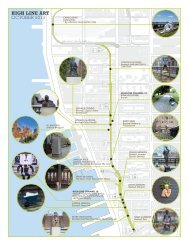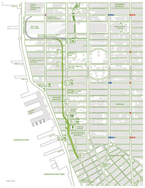
Map - The High Line
Map - The High Line
Map - The High Line

Create successful ePaper yourself
Turn your PDF publications into a flip-book with our unique Google optimized e-Paper software.
PIER 76<br />
PAGE 1 OF 4<br />
PIER 66<br />
GREENWAY & BIKE PATH<br />
PIER 64<br />
HUDSON RIVER<br />
JACOB K.<br />
JAVITS<br />
CONVENTION<br />
CENTER<br />
WEST SIDE<br />
RAIL YARDS<br />
STARRETT-LEHIGH<br />
BUILDING<br />
CHELSEA<br />
PIERS<br />
FUTURE NO. 7<br />
SUBWAY STATION<br />
HIGH LINE AT THE RAIL YARDS<br />
(DEVELOPMENT PENDING)<br />
ELEVENTH AVENUE<br />
CHELSEA<br />
WATERSIDE PARK<br />
GALLERY<br />
DISTRICT<br />
PIER 57<br />
PIER 54<br />
HUDSON RIVER PARK<br />
TENTH AVENUE<br />
CHELSEA<br />
PARK<br />
ELLIOTT-CHELSEA<br />
HOUSES<br />
CLEMENT CLARKE<br />
MOORE PARK<br />
FULTON<br />
HOUSES<br />
CHELSEA<br />
MARKET<br />
MEATPACKING<br />
DISTRICT<br />
NINTH AVENUE<br />
WASHINGTON STREET<br />
HUDSON STREET<br />
WESTBETH<br />
ARTIST HOUSING<br />
WEST 35TH STREET<br />
WEST 34TH STREET<br />
WEST 33RD STREET<br />
WEST 31ST STREET<br />
WEST 30TH STREET<br />
WEST 29TH STREET<br />
WEST 26TH STREET<br />
WEST 25TH STREET<br />
WEST 23RD STREET<br />
WEST 22ND STREET<br />
WEST 21ST STREET<br />
WEST 20TH STREET<br />
WEST 19TH STREET<br />
WEST 18TH STREET<br />
WEST 17TH STREET<br />
WEST 16TH STREET<br />
WEST 15TH STREET<br />
WEST 14TH STREET<br />
GANSEVOORT STREET<br />
HORATIO STREET<br />
JANE STREET<br />
WEST 13TH STREET<br />
W 12TH STREET<br />
BETHUNE STREET<br />
BANK STREET<br />
W 11TH STREET<br />
EIGHTH AVENUE<br />
EIGHTH AVENUE<br />
ABINGDON<br />
SQUARE<br />
GARMENT<br />
DISTRICT<br />
PENNSYLVANIA<br />
STATION<br />
CHELSEA<br />
GREENWICH AVENUE<br />
WEST VILLAGE<br />
W 4TH STREET<br />
SEVENTH AVENUE
PAGE 2 OF 4<br />
RADIAL<br />
BENCH<br />
WILDFLOWER<br />
FIELD<br />
HIGH LINE AT THE RAIL YARDS<br />
PHILIP A. AND LISA MARIA<br />
FALCONE FLYOVER<br />
23RD STREET LAWN<br />
AND SEATING STEPS<br />
TENTH AVENUE TENTH AVENUE<br />
30TH STREET<br />
CUT-OUT<br />
WEST 30TH STREET<br />
WEST 29TH STREET<br />
WEST 28TH STREET<br />
26TH STREET<br />
VIEWING SPUR<br />
WEST 26TH STREET<br />
CHELSEA<br />
THICKET<br />
WEST 25TH STREET<br />
WEST 24TH STREET<br />
WEST 23RD STREET<br />
WEST 22TH STREET<br />
WEST 21ST STREET<br />
WEST 20TH STREET<br />
WEST 19TH STREET
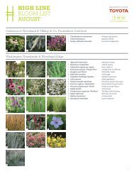
Many design features and plantings on the <strong>High</strong> <strong>Line</strong> were<br />
made possible with support of the visionary leaders:<br />
Diller – von Furstenberg Sundeck<br />
Thanks to <strong>The</strong> Diller – von Furstenberg<br />
Family Foundation<br />
Gansevoort Woodland<br />
Thanks to Donald Pels and Wendy Keys<br />
Tenth Avenue Square<br />
Thanks to Hermine and David Heller,<br />
and Michael and Sukey Novogratz<br />
14th Street Stair<br />
Thanks to Philip A. Falcone and Lisa<br />
Maria Falcone<br />
Historic Railing Restoration, 14th Street<br />
Thanks to Adam and Brittany Levinson<br />
Historic Railing Restoration, 23rd Street<br />
Thanks to John Blondel<br />
Northern Spur Preserve<br />
Thanks to Christy and John Mack<br />
Foundation<br />
Chelsea Grasslands<br />
Thanks to <strong>The</strong> Tiffany & Co. Foundation<br />
Chelsea Thicket South<br />
In memory of Janice H. Levin<br />
PAGE 3 OF 4<br />
Philip A. and Lisa Maria Falcone Flyover<br />
Thanks to Philip A. and Lisa Maria Falcone<br />
26th Street Viewing Spur<br />
Thanks to Sherry and Douglas Oliver,<br />
<strong>The</strong> Hanson Family, and Avenues:<br />
<strong>The</strong> World School<br />
Wildflower Field South<br />
In memory of Mortimer D. Sackler<br />
MD KBE 1916 – 2010<br />
30th Street Cut-Out<br />
Thanks to <strong>The</strong> Pershing Square<br />
Foundation<br />
Thanks to the supporters and members<br />
of Friends of the <strong>High</strong> <strong>Line</strong> who help us<br />
operate and maintain the park every day.<br />
10TH AVENUE<br />
SQUARE<br />
DILLER - VON FURSTENBERG<br />
SUNDECK & WATER FEATURE<br />
GANSEVOORT<br />
WOODLAND<br />
WEST STREET<br />
NORTHERN SPUR<br />
PRESERVE<br />
SOUTHERN SPUR<br />
TENTH AVENUE<br />
HIGH LINE<br />
RESTROOM<br />
WEST 22ND STREET<br />
WEST 21ST STREET<br />
WEST 20TH STREET<br />
WEST 19TH STREET<br />
CHELSEA<br />
GRASSLANDS<br />
WEST 18TH STREET<br />
WEST 17TH STREET<br />
CHELSEA MARKET<br />
PASSAGE<br />
WEST 15TH STREET<br />
WEST 14TH STREET<br />
14TH STREET<br />
PASSAGE<br />
WASHINGTON STREET<br />
FUTURE HIGH LINE<br />
HEADQUARTERS<br />
FUTURE WHITNEY MUSEUM<br />
OF AMERICAN ART<br />
WEST 13TH STREET<br />
LITTLE W 12TH ST<br />
GANSEVOORT STREET
<strong>High</strong> <strong>Line</strong> and Friends of the <strong>High</strong> <strong>Line</strong> Become a Member<br />
<strong>The</strong> <strong>High</strong> <strong>Line</strong> is a public park built on an historic freight rail line elevated<br />
above the streets on Manhattan’s West Side. It is owned by the City of<br />
New York, and maintained and operated by Friends of the <strong>High</strong> <strong>Line</strong>.<br />
Founded in 1999 by community residents, Friends of the <strong>High</strong> <strong>Line</strong> fought<br />
for the <strong>High</strong> <strong>Line</strong>’s preservation and transformation at a time when the<br />
historic structure was under the threat of demolition. It is now the nonprofit<br />
conservancy working with the New York City Department of Parks<br />
& Recreation to make sure the <strong>High</strong> <strong>Line</strong> is maintained as an extraordinary<br />
public space for all visitors to enjoy. In addition to overseeing maintenance,<br />
operations, and public programming for the park, Friends of the <strong>High</strong> <strong>Line</strong><br />
works to raise the essential private funds to support more than 90 percent<br />
of the park’s annual operating budget, and to advocate for the preservation<br />
and transformation of the final section of the <strong>High</strong> <strong>Line</strong> at the rail yards.<br />
Hours<br />
<strong>The</strong> <strong>High</strong> <strong>Line</strong> is open daily. Hours vary by season.<br />
Visit www.thehighline.org or follow @highlinenyc on Twitter for<br />
the latest park information.<br />
<strong>High</strong> <strong>Line</strong> Art<br />
Friends of the <strong>High</strong> <strong>Line</strong> commissions temporary, large-scale, site-specific<br />
works of art for the park, offering a platform for visual, performance,<br />
and sound-based art by both emerging and established artists.<br />
<strong>High</strong> <strong>Line</strong> Programs<br />
Friends of the <strong>High</strong> <strong>Line</strong> offers free and low-cost public programs, including<br />
talks, films, performances, tours, and family activities.<br />
PAGE 4 OF 4<br />
HIGH LINE<br />
MAP<br />
Support from our members provides crucial funding for the ongoing<br />
maintenance and operations of the <strong>High</strong> <strong>Line</strong>, allowing us to hire gardeners<br />
to keep the park’s flowers and trees in peak condition, and maintenance<br />
crews to ensure the <strong>High</strong> <strong>Line</strong> is clean and safe for its visitors. Members<br />
receive a <strong>High</strong> <strong>Line</strong> newsletter, discounts at local stores, and other benefits.<br />
Visit www.thehighline.org to learn more.<br />
Directions<br />
Subway<br />
L or A / C / E to West 14th Street and<br />
8th Avenue<br />
C / E to West 23rd Street and 8th Avenue<br />
1 / 2 / 3 to West 14th Street and 7th Avenue<br />
1 to 18th Street or West 23rd Street and 7th Avenue<br />
Bus<br />
M11 to Washington Street<br />
M11 to 9th Avenue<br />
M14 to 9th Avenue<br />
M23 to 10th Avenue<br />
M34 to 10th Avenue<br />
<strong>The</strong> <strong>High</strong> <strong>Line</strong> is fully wheelchair accessible.<br />
Stay Connected with the <strong>High</strong> <strong>Line</strong><br />
www.thehighline.org<br />
This map was produced by Friends of the <strong>High</strong> <strong>Line</strong>.<br />
Images by Iwan Baan, Barry Munger, and Sean Walsh. <strong>Map</strong> design by OCD.<br />
Second edition © 2011