

MapInfo Spatial Server Web Map Service - Product Documentation ...
MapInfo Spatial Server Web Map Service - Product Documentation ...
MapInfo Spatial Server Web Map Service - Product Documentation ...

Create successful ePaper yourself
Turn your PDF publications into a flip-book with our unique Google optimized e-Paper software.
Defining a WMSLayer<br />
Defining a WMSLayer<br />
14<br />
Since you can have multiple configurations, the layer list and layer tree has been separated to allow for<br />
configuration merging. The WMSLayerList has the list of all available layers that can be provided by the<br />
service.<br />
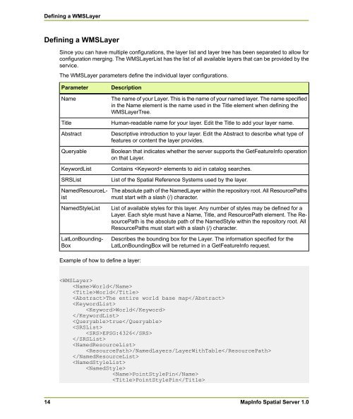
The WMSLayer parameters define the individual layer configurations.<br />
Parameter<br />
Name<br />
Title<br />
Abstract<br />
Queryable<br />
KeywordList<br />
SRSList<br />
NamedResourceList<br />
NamedStyleList<br />
LatLonBounding-<br />
Box<br />
Description<br />
Example of how to define a layer:<br />
The name of your Layer. This is the name of your named layer. The name specified<br />
in the Name element is the name used in the Title element when defining the<br />
WMSLayerTree.<br />
Human-readable name for your layer. Edit the Title to add your layer name.<br />
Descriptive introduction to your layer. Edit the Abstract to describe what type of<br />
features or content the layer provides.<br />
Boolean that indicates whether the server supports the GetFeatureInfo operation<br />
on that Layer.<br />
Contains elements to aid in catalog searches.<br />
List of the <strong>Spatial</strong> Reference Systems used by the layer.<br />
The absolute path of the NamedLayer within the repository root. All ResourcePaths<br />
must start with a slash (/) character.<br />
List of available styles for this layer. Any number of styles may be defined for a<br />
Layer. Each style must have a Name, Title, and ResourcePath element. The ResourcePath<br />
is the absolute path of the NamedStyle within the repository root. All<br />
ResourcePaths must start with a slash (/) character.<br />
Describes the bounding box for the Layer. The information specified for the<br />
LatLonBoundingBox will be returned in a GetFeatureInfo request.<br />
<br />
World<br />
World<br />
The entire world base map<br />
<br />
World<br />
<br />
true<br />
<br />
EPSG:4326<br />
<br />
<br />
/NamedLayers/LayerWithTable<br />
<br />
<br />
<br />
PointStylePin<br />
PointStylePin<br />
<strong><strong>Map</strong>Info</strong> <strong>Spatial</strong> <strong>Server</strong> 1.0


