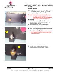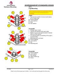
OSSIM Open Source Software Image Map - L-3 Communications
OSSIM Open Source Software Image Map - L-3 Communications
OSSIM Open Source Software Image Map - L-3 Communications

Create successful ePaper yourself
Turn your PDF publications into a flip-book with our unique Google optimized e-Paper software.
<strong>OSSIM</strong><br />
<strong>Open</strong> <strong>Source</strong> <strong>Software</strong> <strong>Image</strong> <strong>Map</strong><br />
<strong>OSSIM</strong> is an advanced, high performance, image<br />
processing library used for the creation and exploitation of<br />
multi-INT data. Linkabit is deploying advanced geospatialmapping<br />
solutions in critical national systems. <strong>OSSIM</strong> is<br />
one such software system for remote sensing, image<br />
processing photogrammetry and mapping. <strong>OSSIM</strong><br />
deployment includes ILabs, NASA, JCTD, and NRL. Based<br />
on open standards, open source software, and servicesbased<br />
architectures, Linkabit's geospatial systems are<br />
providing collaborative technology development and<br />
advanced capabilities to a wide range of users. <strong>Open</strong><br />
systems architectures are robust solutions that can be<br />
easily upgraded over time. Linkabit deploys and supports<br />
geospatial systems based on W3C and OGC specifications.<br />
Advanced Multi-INT Analysis Tools<br />
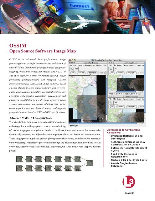
The Visual Chain Editor tool is based on <strong>OSSIM</strong> software<br />
technology that provides graphical construction and editing<br />
of custom image-processing chains. Loaders, combiners, filters, and modular functions can be<br />
dynamically connected and adjusted to combine geospatial data sets in new and innovative ways.<br />
These image processing chains provide photogrammetric accuracy, non-destructive parameter<br />
base processing, radiometric preservation through the processing chain, automatic terrain<br />
correction, and projection transformation. In addition, <strong>OSSIM</strong>'s architecture supports external<br />
plugins.<br />
Advantages to Government<br />
Customers:<br />
• Unlimited Distribution and<br />
User Rights<br />
• Technical and Cross-Agency<br />
Collaboration by Default<br />
• Extremely Rapid Development<br />
Cycles<br />
• Fund Only the Needed<br />
Requirements<br />
• Reduce O&M Life-Cycle Costs<br />
• Avoids Single-<strong>Source</strong><br />
Solutions
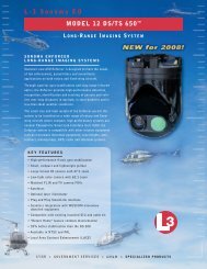
<strong>OSSIM</strong> – <strong>Open</strong> <strong>Source</strong> <strong>Software</strong> <strong>Image</strong> <strong>Map</strong><br />
High Performance Geospatial Processing<br />
<strong>OSSIM</strong> supports parallel processing of data through the use of LAM/MPI. This parallel processing support enables the creation of many<br />
custom imagery products. <strong>OSSIM</strong> has true rigorous sensor model support as well as support for all standard map projections. <strong>Source</strong> data can be<br />
stored in its native format and processed on the fly to meet user specifications. The system can be driven through OCC web services based<br />
interfaces.<br />
<strong>Image</strong> Linker Position Quality Evaluator<br />
TECHNOLOGICAL CHARACTERISTICS<br />
•OPEN-STANDARDS INTERFACES<br />
•OPEN-SOURCE C++ AND JAVA SOFTWARE<br />
•ADVANCED REMOTE SENSING AND IMAGE PROCESSING<br />
• 3D GEOSPATIAL VISUALIZATION SUPPORT<br />
• OGC-COMPLIANT WEB SERVICES<br />
•NATIONAL AND COMMERCIAL FORMATS<br />
•EVALUATED IN 2003 NGA CELTIC PATHFINDER<br />
•PLATFORM INDEPENDENCE:WINDOWS, LINUX, MAC OSX, AND SOLARIS<br />
•ENABLED FOR PARALLEL PROCESSING<br />
•SUPPORT FOR SEPARATE CLASSIFIED PLUG-INS AND FUNCTIONALITY<br />
•SUPPORTS FGDC, OGC,WMS,WFS, AND WCS INTERFACES<br />
•TECHNICAL AND CROSS-AGENCY COLLABORATION BY DEFAULT<br />
•EXTREMELY RAPID DEVELOPMENT CYCLES<br />
•FUND ONLY THE NEEDED REQUIREMENTS<br />
Note: All specifications subject to change without notice<br />
Cleared by DoD/OSR for public release under<br />
OSR Case Number 07-S-2670 on August 24, 2007.<br />
LINKABIT DIVISION<br />
1200 S. WOODY BURKE ROAD P.O. BOX 550 MELBOURNE, FL 32902-0550<br />
(321) 727-0660 FAX (321) 952-1689 WWW.L-3COM.COM<br />
P ro d u c t S e r v i c e H e l p D e s k : 1 - 8 0 0 - 3 3 1 - 9 4 0 1<br />
e - m a i l : L i n k a b i t P ro d u c t s @ L - 3 c o m . c o m<br />
1078058001