PointCloud 8.0 What's new? - download - Kubit GmbH
PointCloud 8.0 What's new? - download - Kubit GmbH
PointCloud 8.0 What's new? - download - Kubit GmbH

You also want an ePaper? Increase the reach of your titles
YUMPU automatically turns print PDFs into web optimized ePapers that Google loves.
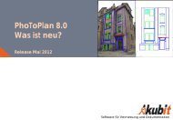
<strong>PointCloud</strong> <strong>8.0</strong><br />
What‘s <strong>new</strong>?<br />
Release May 2012<br />
Software for surveying and as-build documentation
Overview – What‘s <strong>new</strong><br />
General<br />
� Compatible with AutoCAD 2013<br />
� Support of more scan data formats<br />
� More comfortable inserting and managing of point clouds<br />
� Creation of elevation map<br />
� Deformation analysis faster and easier<br />
� Improvements when working with planar views<br />
� New help system<br />
� Patch: section colors are now used for export and ortho image creation<br />
<strong>PointCloud</strong> Pro<br />
� Draw outline plans and elevations easier by using the planar view<br />
� New commands for 3D evaluation and modeling<br />
� Improved image orientation<br />
� Extended and improved multiple image evaluation<br />
kubit <strong>GmbH</strong> Software for surveying and as-built documentation www.kubit-software.com<br />
2
<strong>PointCloud</strong> General – Compatibility<br />
Operating systems:<br />
� All 32 bit - and 64 bit - versions of Windows 7, Vista and XP<br />
Compatibility with AutoCAD:<br />
� Supports AutoCAD 2013<br />
� Supports all Autodesk products based on AutoCAD 2013,<br />
like<br />
− Plant 3D 2013<br />
− Architecture 2013<br />
− Civil 3D 2013<br />
� Supports older AutoCAD versions of 2010 and higher<br />
� For older systems a previous version of <strong>PointCloud</strong> can be<br />
provided.<br />
kubit <strong>GmbH</strong> Software for surveying and as-built documentation www.kubit-software.com<br />
3
More scan data formats<br />
So far<br />
� Import of: ASCII (including PTS), Leica (PTZ), Riegl (RSP Polydata),<br />
FARO (FLS, FWS AutoCAD 2011 and higher), LAS (AutoCAD 2011 and higher)<br />
� Creating: ASCII, PTC, PCG and AutoCAD points<br />
� For planar view: FARO (FLS, FWS), Leica (PTZ), PTX (supported by<br />
various scanner manufacturers), Export to PTC<br />
NEW:<br />
� Import of: E57 (ASTM standard), Leica (PTG), Zoller&Fröhlich (ZFS,<br />
ZFPRJ), Topcon (CL3, CLR) all AutoCAD 2011 and higher<br />
� For planar view: FARO (LSPROJ), Riegl (RSP referenced RXP scans),<br />
Export to LAS<br />
kubit <strong>GmbH</strong> Software for surveying and as-built documentation www.kubit-software.com<br />
4
<strong>PointCloud</strong> General – New Features<br />
3D distance dimension<br />
The three-dimensional distance of two points<br />
within space can be determined and<br />
dimensioned with this command. The 3D<br />
dimensioning automatically adapts to the current<br />
view, so that the distance dimension can always<br />
be read clearly.<br />
The 3D dimensioning is intended for the fast<br />
determination of distances and the presentation of<br />
spatial data.<br />
No matter from which direction you look at<br />
the 3D model – you will always be able to<br />
read the distance dimensioning.<br />
kubit <strong>GmbH</strong> Software for surveying and as-built documentation www.kubit-software.com<br />
5
<strong>PointCloud</strong> General – Improvements<br />
More comfortable inserting and<br />
managing of point clouds<br />
Data exchange is now easier since it is now<br />
possible to define how the point cloud shall be<br />
referenced in the drawing.<br />
The zoom can now be focused to the <strong>new</strong>ly<br />
inserted point cloud. This prevents longer search<br />
and navigation in large projects.<br />
No complicated calculation and entering of<br />
scale factors. The point cloud is automatically<br />
scaled according to the drawing scale.<br />
Want to zoom to the<br />
inserted point cloud?<br />
kubit <strong>GmbH</strong> Software for surveying and as-built documentation www.kubit-software.com<br />
How shall the point cloud be<br />
referenced?<br />
Allows to<br />
scale the<br />
point cloud<br />
correctly<br />
and easily.<br />
6
<strong>PointCloud</strong> General – Improvements<br />
Flexible display of the section marker<br />
For some users highlighting the point cloud sections by<br />
a marker is disturbing. Therefore they have now the<br />
option to turn the section markers off. The style of the<br />
section marker can also be changed.<br />
kubit <strong>GmbH</strong> Software for surveying and as-built documentation www.kubit-software.com<br />
7
<strong>PointCloud</strong> General – Improvements<br />
Faster and more flexible management<br />
of point cloud sections<br />
Name, color and display of sections can now<br />
also be changed and controlled via the <strong>new</strong><br />
context menu – besides the possibilities via the<br />
main interface of the section manager.<br />
Selected section can be isolated fast and easy –<br />
similar to the AutoCAD layer manager.<br />
The context menu provides <strong>new</strong> logical functions<br />
for the creation of sections from existing sections,<br />
which help to speed up the evaluation.<br />
… for one or<br />
kubit <strong>GmbH</strong> Software for surveying and as-built documentation www.kubit-software.com<br />
Right click opens<br />
context menu …<br />
… multiple sections<br />
8
<strong>PointCloud</strong> General – Improvements<br />
Remove disturbing sections but keep those behind them<br />
An example: You aim to display the façade without the disturbing tree by doing just<br />
a few clicks. This can be achieved by clipping out the tree and subsequently<br />
inverting the point cloud section.<br />
kubit <strong>GmbH</strong> Software for surveying and as-built documentation www.kubit-software.com<br />
9
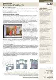
<strong>PointCloud</strong> General – Improvements<br />
Elevation map with legend<br />
Using the command for changing the<br />
color one may color the points of a<br />
section by their distance to the xy-plane<br />
of the current User Coordinate System.<br />
This way an elevation map of the point<br />
cloud can be created without needing<br />
to define any slices.<br />
In addition it is possible to create and<br />
insert the according map legend.<br />
Insert legend<br />
kubit <strong>GmbH</strong> Software for surveying and as-built documentation www.kubit-software.com<br />
Color section as<br />
elevation map<br />
10
<strong>PointCloud</strong> General – Improvements<br />
Deformation analysis of<br />
planar objects<br />
Using the same method as for<br />
the creation of an elevation map<br />
one may easily analyze the<br />
deformation of planar objects<br />
and create the according<br />
report.<br />
Define average plane and the UCS from this plane<br />
Color the section by elevation and create legend<br />
For handing on create ortho image and print the map<br />
kubit <strong>GmbH</strong> Software for surveying and as-built documentation www.kubit-software.com
<strong>PointCloud</strong> General – Improvements<br />
Improvements when working with the planar view<br />
As before scan data can be opened in a photo-like planar view for display, measurement and<br />
evaluation. This allows a more intuitive navigation than in a point cloud view. No accidentally<br />
snapping of hidden points possible.<br />
NEW:<br />
Scan Map provides<br />
overview and<br />
makes navigation<br />
to the desired scan<br />
easy.<br />
The whole scan<br />
project not only<br />
single scans loaded<br />
Customized<br />
macros can easily<br />
be transferred<br />
kubit <strong>GmbH</strong> Software for surveying and as-built documentation www.kubit-software.com<br />
More pre-defined<br />
macros for the<br />
evaluation<br />
12
<strong>PointCloud</strong> General – Improvements<br />
Improved help system<br />
In all dialogs you get help for the command you<br />
currently use.<br />
Quick access to the according manual chapter.<br />
Click on the kubit help icon<br />
opens the manual for the<br />
particular command<br />
kubit <strong>GmbH</strong> Software for surveying and as-built documentation www.kubit-software.com<br />
13
<strong>PointCloud</strong> Pro – New Features<br />
3D modeling with kubit planes<br />
The <strong>new</strong> "Intersection lines (3 planes)" command generates a spatial trihedron.<br />
Therefore intersection point and intersecting lines of the three selected planes are visible.<br />
The command makes the generation of wireframe models by means of planes easier.<br />
kubit <strong>GmbH</strong> Software for surveying and as-built documentation www.kubit-software.com<br />
14
<strong>PointCloud</strong> Pro – Improvements<br />
Draw outline plans and elevations<br />
easier by using the planar view<br />
� No need to load the bulky point cloud into<br />
AutoCAD<br />
� Avoids snapping hidden points by accident<br />
� Simply click two point on each wall.<br />
� The corners are automatically sharpend.<br />
(Command: PCDCONT , Mode: Fitting off)<br />
kubit <strong>GmbH</strong> Software for surveying and as-built documentation www.kubit-software.com<br />
15
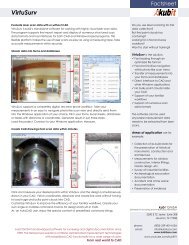
Working with images – Improved Functions<br />
Image rectification and image<br />
orientation faster and more comfortable<br />
Automatic zoom during assignment of control<br />
points and image points speeds up the process of<br />
image rectification and image orientation.<br />
Scalable dialogs provide better overview in the<br />
point lists.<br />
Lists inside dialogs can now<br />
be sorted.<br />
Automatically<br />
zoom to the<br />
image point<br />
Click on the column header for sorting<br />
No scrolling since dialog is scalable<br />
kubit <strong>GmbH</strong> Software for surveying and as-built documentation www.kubit-software.com<br />
16
Working with images – Improved Functions<br />
Multiple image evaluation<br />
The display of the Epipolar line makes the<br />
evaluation in oriented images much easier.<br />
Since corresponding points always lie on this line<br />
you may also evaluate structures for which the<br />
point assignment is not distinct.<br />
The commands for the dual image evaluation<br />
have been extended to evaluation with multiple<br />
images. Thus the evaluation can be overdetermined.<br />
This makes it possible to check the<br />
accuracy.<br />
A protocol point block is created for every point<br />
that has been determined by multiple image<br />
evaluation. For accuracy check and proof these<br />
blocks can be displayed and if needed exported<br />
to a text file.<br />
Point in first image<br />
kubit <strong>GmbH</strong> Software for surveying and as-built documentation www.kubit-software.com<br />
The same point in<br />
second image<br />
17
Contact<br />
kubit <strong>GmbH</strong><br />
Tiergartenstraße 79<br />
01219 Dresden<br />
Germany<br />
phone: +49 351 418880-0<br />
fax: +49 351 418880-0<br />
email: info@kubit-software.com<br />
web: www.kubit-software.com<br />
www.kubit-software.com<br />
kubit <strong>GmbH</strong> Software for surveying and as-built documentation www.kubit-software.com 18