Air, land and water in the Wellington region - Greater Wellington ...
Air, land and water in the Wellington region - Greater Wellington ...
Air, land and water in the Wellington region - Greater Wellington ...

Create successful ePaper yourself
Turn your PDF publications into a flip-book with our unique Google optimized e-Paper software.
Tauherenikau River<br />
on<br />
#<br />
#<br />
# #<br />
rt<strong>in</strong>borough<br />
Dry River<br />
E<br />
Waioh<strong>in</strong>e River<br />
Pukio<br />
Ruakokoputuna River<br />
Makara River<br />
ilometres<br />
Water resources – what’s be<strong>in</strong>g used<br />
<strong>and</strong> how much is left?<br />
The answers are ‘a lot’, <strong>and</strong> ‘not that much’. As at <strong>the</strong> end<br />
of 2010, 270.3 million cubic metres per year of <strong>water</strong> was<br />
allocated through resource consents <strong>in</strong> <strong>the</strong> Wairarapa – 120.2<br />
million cubic metres more than <strong>in</strong> 1990. Just over half of <strong>the</strong><br />
current <strong>water</strong> allocation is to irrigate pasture, orchards, crops<br />
<strong>and</strong> v<strong>in</strong>eyards; o<strong>the</strong>r significant uses are for town <strong>water</strong><br />
supplies <strong>and</strong> agricultural <strong>water</strong> races. Nearly 70% of <strong>the</strong><br />
Wairarapa’s allocated <strong>water</strong> comes from surface <strong>water</strong> (rivers,<br />
streams <strong>and</strong> Lake Wairarapa), with <strong>the</strong> rema<strong>in</strong>der from<br />
ground<strong>water</strong> aquifers.<br />
Most of <strong>the</strong> <strong>in</strong>crease <strong>in</strong> allocation between 1990 <strong>and</strong> 2010 was<br />
for dairy pasture irrigation. Many of <strong>the</strong> rivers <strong>and</strong> streams <strong>in</strong><br />
<strong>the</strong> Wairarapa Valley are now ‘fully allocated’, which means<br />
additional <strong>water</strong> takes would affect <strong>the</strong>ir ability to support<br />
aquatic life, <strong>and</strong> compromise o<strong>the</strong>r uses such as recreation.<br />
E<br />
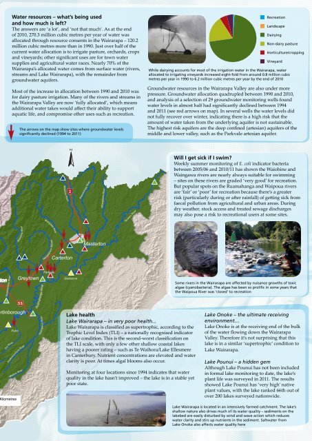
The arrows on <strong>the</strong> map show sites where ground<strong>water</strong> levels<br />
significantly decl<strong>in</strong>ed (1994 to 2011)<br />
#<br />
#<br />
#<br />
#<br />
E E Parkvale E E<br />
E<br />
Greytown<br />
Mangatarere Stream<br />
Ruamahanga River<br />
Huangarua River<br />
Wa<strong>in</strong>gawa River<br />
#<br />
Waipoua River<br />
E<br />
N<br />
E #<br />
#<br />
Carterton<br />
#<br />
#<br />
# #<br />
Gladstone<br />
Kopuaranga River<br />
#<br />
EE<br />
Whangaehu River<br />
Masterton<br />
Tauweru River<br />
Lake health<br />
Lake Wairarapa – <strong>in</strong> very poor health...<br />
Lake Wairarapa is classified as supertrophic, accord<strong>in</strong>g to <strong>the</strong><br />
Trophic Level Index (TLI) – a nationally recognised <strong>in</strong>dicator<br />
of lake condition. This is <strong>the</strong> second-worst classification on<br />
<strong>the</strong> TLI scale, with only a few o<strong>the</strong>r shallow coastal lakes<br />
hav<strong>in</strong>g a poorer rat<strong>in</strong>g – such as Te Waihora/Lake Ellesmere<br />
<strong>in</strong> Canterbury. Nutrient concentrations are elevated <strong>and</strong> <strong>water</strong><br />
clarity is poor. At times algal blooms also occur.<br />
Monitor<strong>in</strong>g at four locations s<strong>in</strong>ce 1994 <strong>in</strong>dicates that <strong>water</strong><br />
quality <strong>in</strong> <strong>the</strong> lake hasn’t improved – <strong>the</strong> lake is <strong>in</strong> a stable yet<br />
poor state.<br />
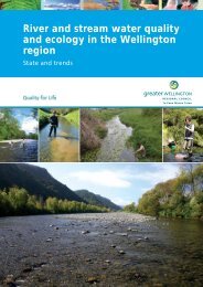
While dairy<strong>in</strong>g accounts for most of <strong>the</strong> irrigation <strong>water</strong> <strong>in</strong> <strong>the</strong> Wairarapa, <strong>water</strong><br />
allocated to irrigat<strong>in</strong>g v<strong>in</strong>eyards <strong>in</strong>creased eight-fold from around 0.8 million cubic<br />
metres per year <strong>in</strong> 1990 to 6.2 million cubic metres per year by <strong>the</strong> end of 2010<br />
Ground<strong>water</strong> resources <strong>in</strong> <strong>the</strong> Wairarapa Valley are also under more<br />
pressure. Ground<strong>water</strong> allocation quadrupled between 1990 <strong>and</strong> 2010,<br />
<strong>and</strong> analysis of a selection of 29 ground<strong>water</strong> monitor<strong>in</strong>g wells found<br />
<strong>water</strong> levels <strong>in</strong> almost half had significantly decl<strong>in</strong>ed between 1994<br />
<strong>and</strong> 2011 (see red arrows on map). In several wells <strong>the</strong> <strong>water</strong> levels did<br />
not fully recover over w<strong>in</strong>ter, <strong>in</strong>dicat<strong>in</strong>g <strong>the</strong>re is a high risk that <strong>the</strong><br />
amount of <strong>water</strong> taken from <strong>the</strong> underly<strong>in</strong>g aquifer is not susta<strong>in</strong>able.<br />
The highest risk aquifers are <strong>the</strong> deep conf<strong>in</strong>ed (artesian) aquifers of <strong>the</strong><br />
middle <strong>and</strong> lower valley, such as <strong>the</strong> Parkvale artesian aquifer.<br />
#<br />
Recreation<br />
L<strong>and</strong>scape<br />
Dairy<strong>in</strong>g<br />
Non-dairy pasture<br />
Horticulture/cropp<strong>in</strong>g<br />
V<strong>in</strong>eyard<br />
Will I get sick if I swim?<br />
Weekly summer monitor<strong>in</strong>g of E. coli <strong>in</strong>dicator bacteria<br />
between 2005/06 <strong>and</strong> 2010/11 has shown <strong>the</strong> Waioh<strong>in</strong>e <strong>and</strong><br />
Wa<strong>in</strong>gawa rivers are nearly always suitable for swimm<strong>in</strong>g<br />
– sites on <strong>the</strong>se rivers are graded ‘very good’ for recreation.<br />
But popular spots on <strong>the</strong> Ruamahanga <strong>and</strong> Waipoua rivers<br />
are ‘fair’ or ‘poor’ for recreation because <strong>the</strong>re’s a greater<br />
risk (particularly dur<strong>in</strong>g or after ra<strong>in</strong>fall) of gett<strong>in</strong>g sick from<br />
faecal pollution from agricultural <strong>and</strong> urban areas. Dur<strong>in</strong>g<br />
dry wea<strong>the</strong>r, stock access <strong>and</strong> treated sewage discharges<br />
may also pose a risk to recreational users at some sites.<br />
Some rivers <strong>in</strong> <strong>the</strong> Wairarapa are affected by nuisance growths of toxic<br />
algae (cyanobacteria). The algae has been so prolific <strong>in</strong> some years that<br />
<strong>the</strong> Waipoua River was ‘closed’ to recreation<br />
Lake Onoke – <strong>the</strong> ultimate receiv<strong>in</strong>g<br />
environment…<br />
Lake Onoke is at <strong>the</strong> receiv<strong>in</strong>g end of <strong>the</strong> bulk<br />
of <strong>the</strong> <strong>water</strong> flow<strong>in</strong>g down <strong>the</strong> Wairarapa<br />
Valley. Therefore it’s not surpris<strong>in</strong>g that this<br />
lake is <strong>in</strong> a similar ‘supertrophic’ condition to<br />
Lake Wairarapa.<br />
Lake Pounui – a hidden gem<br />
Although Lake Pounui has not been <strong>in</strong>cluded<br />
<strong>in</strong> formal lake monitor<strong>in</strong>g to date, <strong>the</strong> lake’s<br />
plant life was surveyed <strong>in</strong> 2011. The results<br />
showed Lake Pounui has ‘very high’ native<br />
plant values, with <strong>the</strong> lake ranked 66th out of<br />
over 200 lakes surveyed nationwide.<br />
Lake Wairarapa is located <strong>in</strong> an <strong>in</strong>tensively farmed catchment. The lake’s<br />
shallow nature also drives much of its <strong>water</strong> quality – sediments on <strong>the</strong><br />
lakebed are easily disturbed by w<strong>in</strong>d <strong>and</strong> wave action which reduces<br />
<strong>water</strong> clarity <strong>and</strong> stirs up nutrients <strong>in</strong> <strong>the</strong> sediment. Salt<strong>water</strong> from<br />
Lake Onoke also affects <strong>water</strong> quality here