Air, land and water in the Wellington region - Greater Wellington ...
Air, land and water in the Wellington region - Greater Wellington ...
Air, land and water in the Wellington region - Greater Wellington ...

You also want an ePaper? Increase the reach of your titles
YUMPU automatically turns print PDFs into web optimized ePapers that Google loves.
!<br />
!<br />
a<br />
Taupo Stream<br />
merton<br />
!<br />
!<br />
tream<br />
Browns Stream<br />
!<br />
!<br />
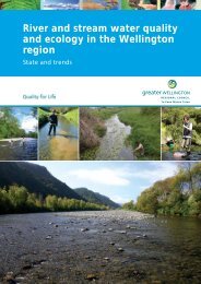
Z<strong>in</strong>c (mg/kg)<br />
Will I get sick if I swim?<br />
There is an <strong>in</strong>creased risk of illness from contact recreation at some of <strong>the</strong> 15 coastal sites monitored<br />
(particularly if you eat shellfish ga<strong>the</strong>red <strong>the</strong>re). Weekly summer monitor<strong>in</strong>g of <strong>in</strong>dicator bacteria<br />
levels has shown that Plimmerton at South Beach, Porirua Harbour at Row<strong>in</strong>g Club <strong>and</strong> <strong>the</strong> sou<strong>the</strong>rn<br />
end of Titahi Bay breach national recreational <strong>water</strong> quality guidel<strong>in</strong>es <strong>the</strong> most. These sites, along<br />
with Browns Bay, are graded ‘poor’ for recreation. This is due to<br />
faecal contam<strong>in</strong>ation from a comb<strong>in</strong>ation of <strong>water</strong>fowl (South<br />
Beach), <strong>and</strong> sewer or storm<strong>water</strong> dra<strong>in</strong>s.<br />
Girls play<strong>in</strong>g at Pukerua Bay<br />
Pukerua Bay<br />
!<br />
Kakaho Stream<br />
Duck Creek<br />
N<br />
"<br />
!<br />
"<br />
"<br />
Pauatahanui Arm<br />
Onepoto Arm<br />
" "<br />
#<br />
#<br />
" "<br />
"<br />
Pauatahanui<br />
Pauatahanui Stream<br />
Pauatahanui Arm<br />
Average (<strong>and</strong> range) z<strong>in</strong>c levels from<br />
four surveys (2004 to 2010)<br />
Horokiri<br />
Stream<br />
In contrast, Porirua Harbour at <strong>the</strong> Paremata Bridge <strong>and</strong><br />
Onehunga Bay are currently graded ‘good’ for recreation – <strong>water</strong><br />
quality at <strong>the</strong>se sites rarely fails national guidel<strong>in</strong>es. Sites graded<br />
‘fair’ breach guidel<strong>in</strong>es at times, especially after ra<strong>in</strong>fall.<br />
What is <strong>the</strong> condition of Porirua Harbour?<br />
We’ve been monitor<strong>in</strong>g ecological health <strong>in</strong> both arms of <strong>the</strong><br />
harbour s<strong>in</strong>ce 2004. The table shows <strong>the</strong> key <strong>in</strong>dicators we<br />
measure <strong>and</strong> highlights <strong>the</strong> state of <strong>the</strong> <strong>in</strong>tertidal s<strong>and</strong> flats.<br />
Here, sediment contam<strong>in</strong>ant levels are generally low <strong>and</strong> <strong>the</strong><br />
<strong>in</strong>vertebrate communities are reasonably diverse. However,<br />
across four annual surveys between 2008 <strong>and</strong> 2011, we found<br />
nuisance levels of algae on some s<strong>and</strong>flat areas, <strong>and</strong> a decl<strong>in</strong>e <strong>in</strong><br />
<strong>the</strong> depth of <strong>the</strong> oxygenated layer <strong>in</strong> <strong>the</strong> surface sediments.<br />
Between 2008 <strong>and</strong> 2011 <strong>the</strong> depth of oxygenated<br />
sediment (<strong>in</strong>dicated by <strong>the</strong> lighter-coloured<br />
surface layer) at all four <strong>in</strong>tertidal monitor<strong>in</strong>g<br />
sites <strong>in</strong> both arms of <strong>the</strong> harbour decreased from<br />
around 4–5 cm to just 1 cm. Low oxygen levels<br />
restrict what is able to live <strong>in</strong> <strong>the</strong> sediment<br />
Recreation grade<br />
Very Good<br />
Good<br />
Fair<br />
Poor<br />
Very Poor<br />
Issue Indicator Onepoto Arm Pauatahanui Arm<br />
Sedimentation<br />
Mud content (%)<br />
Sedimentation rate (mm/yr)<br />
Low but <strong>in</strong>creas<strong>in</strong>g <strong>in</strong> upper estuary areas<br />
Low – moderate (higher <strong>in</strong> subtidal areas)<br />
Organic <strong>and</strong> nutrient content Low – no obvious trends<br />
Nutrient<br />
Sediment oxygenation<br />
Poor – was ‘good’ <strong>in</strong> 2008 <strong>and</strong> has been<br />
decl<strong>in</strong><strong>in</strong>g s<strong>in</strong>ce<br />
enrichment<br />
Moderate<br />
Nuisance algae cover<br />
(over 20% of <strong>the</strong> Onepoto Arm<br />
has more than 50% cover)<br />
Toxic<br />
contam<strong>in</strong>ation<br />
Heavy metal levels<br />
Low – except <strong>in</strong> <strong>in</strong>tertidal sediments near stream<br />
mouths <strong>and</strong> storm<strong>water</strong> outfalls<br />
Habitat<br />
modification<br />
Saltmarsh <strong>and</strong> seagrass loss High Moderate<br />
�<br />
�<br />
In <strong>the</strong> deeper parts of <strong>the</strong> harbour contam<strong>in</strong>ants that are<br />
washed <strong>in</strong> from <strong>the</strong> storm<strong>water</strong> outfalls are collect<strong>in</strong>g <strong>in</strong> <strong>the</strong><br />
sediments. It’s worse <strong>in</strong> <strong>the</strong> Onepoto Arm where heavy metal<br />
concentrations are near or above early warn<strong>in</strong>g guidel<strong>in</strong>es.<br />
Across four surveys to date, z<strong>in</strong>c levels are <strong>in</strong>creas<strong>in</strong>g <strong>in</strong> <strong>the</strong><br />
sediments of this arm. It’s still too early to underst<strong>and</strong> <strong>the</strong><br />
ecological significance of this, but <strong>the</strong> diversity <strong>and</strong> abundance<br />
of small <strong>in</strong>vertebrate animals is less <strong>in</strong> <strong>the</strong> Onepoto Arm<br />
than <strong>in</strong> <strong>the</strong> Pauatahanui Arm – this difference is l<strong>in</strong>ked to <strong>the</strong><br />
higher amount of mud, organic matter <strong>and</strong> metals found <strong>in</strong> <strong>the</strong><br />
Onepoto Arm sediments.<br />
Wriggle Ltd<br />
Thick growths of algae regularly<br />
cover large areas of Porirua<br />
Harbour’s s<strong>and</strong>flats<br />
�<br />
In 2008 saltmarsh cover <strong>in</strong> <strong>the</strong><br />
Pauatahanui Arm was estimated<br />
at 50 hectares – this compares<br />
with less than a hectare <strong>in</strong> <strong>the</strong><br />
Onepoto Arm. Seagrass cover<br />
fares slightly better at 41 <strong>and</strong> 17<br />
hectares <strong>in</strong> <strong>the</strong> Pauatahanui <strong>and</strong><br />
Onepoto arms, respectively<br />
Wriggle Ltd<br />
�