present investigation, include compressive strength, tensile strength, water-absorption and specifice gravity. All these properties are compared with the American standards of testing materials, which are used as standard reference. REGIONAL GEOLOGY AND TECTONIC FRAMEWORK <strong>The</strong> Indo-Pakistan and Asian plates are directly in contact along the Indus-Tsangbo Suture Zone (ITS) in India and Nepal (Gansser, 1980), but are separated from one another by the rocks of the Kohistan arc sequence in NW Pakistan (Fig.1). <strong>The</strong> Kohistan sequence was sutured to the Asian plate along the Northern, or Shyok, suture at about 100 Ma (Coward et al., 1986; Treloar et al., 1989) well before the onset of Himalayan collision. <strong>The</strong> Himalayan collision in northern Pakistan was thus between the Kohistan sequence and the Indo-pakistan plate along the Main Mantle Thrust (MMT). It is generally believed (e.g. Treloar et al., 1989) that following its collision in the early Tertiary, the Kohistan arc was thrust southwards onto the Indo-Pakistan plate. <strong>The</strong> Swat valley, Hazara and adjoining parts of northern Pakistan, therefore, consist of three major tectonostratigraphic units. From north to south (Fig. I), these are (1) the Kohistan island arc, (2) the Main Mantle Thrust . melange group and (3) the Indo-Pakistan plate sequence. <strong>The</strong> rocks studied during the present investigation belong to the Indo- Pakistan plate sequence. In northern Pakistan, the northernmost part of the Indo-Pakistan plate has assumed fiepshape Ha -+oop,,-Rrmwn as-tk Wangz Parbat-Haramosh massif, consisting of Precambrian gneisses intruded by early Cambrian granitoids (Chamberlain et al., 1989). Rocks of the Hazara region lying southwest of the Nanga Parbat and constituting the eastern part of the northern edge of the Indo-Pakistan crust in northern Pakistan (Fig. 1) consist of Precambrian basement overlain unconformably by Phanerozoic rnetasediments . <strong>The</strong> basement rocks of the Hazara area, like their northeastern counterparts in the Nanga Parbat region, were intruded during the Cambrian by the coarse-grained <strong>Mansehra</strong> porphyritic granites (Le Fort et al., 1980; Shams, 1983) (Figs. 1, 2). APPROACH AND METHODOLOGY As mentioned above, the present research work is concerned with petrographic study and mechanical properties of granitic rocks from different localities in the <strong>Mansehra</strong> district (Figs. l,2). Block samples were collected from three localities, i.e. the areas around <strong>Mansehra</strong>, Baffa and Susilgali (Fig.2). Each of the collected block samples was 2-2.5 feet long, 1-0.5 feet wide, and '0.5 foot thick. <strong>The</strong> idea of selecting different localities was to get a wide range of representative samples differing in colour, mineralogy, texture and /or structure, thus providing a good opportunity to relate the mechanical properties of the rocks with their mineralogical and structural characteristics. <strong>The</strong> collected samples were processed for their petrographic study and determination of their geotechnical properties. Two small chips from each block sample were cut and made into thin sections for petrographic observations. Samples used for determining the different mechanical properties of the rocks were prepared by using core drill machine, &aimd+~ saw grinds 4abd~ucfacegrinder. Cylindrical cores were prepared by a thin wall bit of tungsten carbide attached to core barrel. Water was admitted through a swivel in the core barrel to clear drill cuttings and cool the bit. <strong>The</strong> cores obtained by this
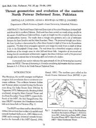
[A .Incham Group I / y lD Panjal Irnbricacr Fig. 1. Geological map of the area south of the Main Mantle Thrust between the Swat and Kaghan valleys (redrawn from Treloar & Rex, 1990) Abbreviations: AT = Alpurai Thust; BSZ = Balakot Shear Zone; BT = Batal Thrust; IR = Indus River; KF = Khannian Fault; MBT = Main Boundary Thrust; MMT = Main Mantle Thrust; PT = Panjal Thrust; TSZ = Thakot Shear Zone.