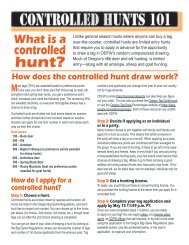
SPOrT FISHIng regulaTIOnS - Oregon Department of Fish and Wildlife
SPOrT FISHIng regulaTIOnS - Oregon Department of Fish and Wildlife
SPOrT FISHIng regulaTIOnS - Oregon Department of Fish and Wildlife

Create successful ePaper yourself
Turn your PDF publications into a flip-book with our unique Google optimized e-Paper software.
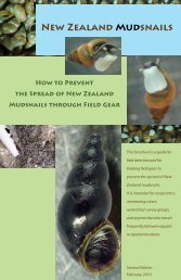
Prairie Channel<br />
Minaker Isl<strong>and</strong><br />
PACIFIC OCEAN<br />
Cape Disappointment<br />
46° 15’ 48” N/124° 05’ 20” W<br />
Buoy 7<br />
46° 15’ 09” N/<br />
124° 06’ 18” W<br />
Buoy 4<br />
46° 13’ 35” N/124° 06’ 50” W<br />
North Jetty<br />
Text highlighted in blue is new or changed from 2012<br />
Prairie ChannelGnat<br />
Karlson Isl<strong>and</strong><br />
Knappa<br />
Slough<br />
McKenzie<br />
Head<br />
Columbia Recreational<br />
Control Zone<br />
Big Creek<br />
South Jetty<br />
Blind<br />
46° 14’ 03” N/124° 04’ 05” W<br />
S<strong>and</strong> Is.<br />
Buoy 10<br />
Eastern boundary <strong>of</strong> CZ<br />
formed by n/s line bearing<br />
357 degrees true from:<br />
46° 14’ 00” N/124° 03’ 07” W<br />
0 1 2<br />
Miles<br />
Slough<br />
O r e g o n<br />
Clatsop Spit<br />
Net Pen Site<br />
Creek<br />
Aldrich Point<br />
Road Bridge<br />
Columbia<br />
Control<br />
Zone<br />
Columbia River<br />
<strong>Oregon</strong> <strong>Department</strong> <strong>of</strong> <strong>Fish</strong> <strong>and</strong> <strong>Wildlife</strong> 95<br />
COLUMBIA<br />
Pages 92 - 99